

Revealing the (un-)known in marginal landscapes. Multi-scalar LiDAR applications in the mountainous area of Monti Aurunci (Latium)
- Title
- Revealing the (un-)known in marginal landscapes. Multi-scalar LiDAR applications in the mountainous area of Monti Aurunci (Latium)
- Creator(s)
- Edoardo VanniSee all items with this value
- Giuseppe Prospero CiriglianoSee all items with this value
- Alessandra CammisolaSee all items with this value
- Simone ZoccoSee all items with this value
- Date
- 2025
- Is Part Of
-
 Archeologia e Calcolatori
- Volume
- 36
- Issue
- 1
- Pages
- 109-128
- Language
- eng
- Abstract
- The Monti Aurunci Regional Park, located in southern Lazio, Italy, is renowned for its geological and naturalistic features as well as its archaeological significance. This area hosts a wealth of archaeological sites covering from pre-Roman and Roman periods to the modern era, many of which remain largely unexplored. These sites are currently being investigated as part of the Monti Aurunci Project (MAP, https://www.archeologiadiffusa.org/2022/09/17/ map/), an initiative led by the University for Foreigners of Siena. Among the notable sites in this region is the multi-layered and abandoned hillfort known as ‘Le Mura di Campello’. How- ever, dense forest cover significantly hinders the identification, interpretation, and mapping of archaeological remains in the area. Furthermore, the lack or low quality of existing datasets limits their usability for archaeological purposes. To address these challenges, a drone-based LiDAR survey was conducted in the winter of 2023, yielding high-resolution data that have proven invaluable for archaeological analysis. With an average point density of 142 points per square meter, the LiDAR data facilitated the identification of numerous archaeological features, enriching the understanding of the Monti Aurunci’s cultural heritage. Over 100 previously undocumented features were mapped, including terracing systems, hillforts, dwellings, walls, and road system. The results obtained have refined our understanding of the historical settlement dynamics in the Monti Aurunci area and opened the door to new methodological approaches, offering promising future research directions.
- Tag
- Remote Sensing
- References
-
 Monti Aurunci Project
-
 LiDAR360
-
 DJI Terra
-
 Applanix POSPac
-
 Cloud Compare
-
 ArcGIS Pro
-
 Quantum GIS
- Cites
- Tabularium Casinense, Codex Diplomaticus Cajetanus, t. II
- Tabularium Casinense, Codex Diplomaticus Cajetanus, t. I
- Tabularium Casinense, Codex Diplomaticus Cajetanus, t. III, pars II
- LiDAR applications in archaeology: A systematic review
- Redescobrint el paisatge medieval del Laci du sud (Italia). El Monti Aurunci Project (MAP)
- Marginality on the stage: The Monti Aurunci Project (MAP)
- Interpolation of airborne LiDAR data for archaeology
- Airborne LiDAR point cloud processing for archaeology. pipeline and QGIS toolbox
- Revealing historical landscapes by using airborne laser scanning. A 3-d model of ridge and furrow in forests near Rastatt (Germany)
- Campello nei Monti Aurunci: osservazioni preliminari sui sistemi di gestione delle acque nella Piana del Campo
- Drones in Archaeology. State-of-the-art and Future Perspectives
- The structure of the Aurunci Mountains (southern Lazio): A balanced cross-section and its restoration
- Inventarium Honorati Gaietani: l'inventario dei beni di Onorato II Gaetani d'Aragona (1491-1493)
- Mining under the canopy: Unveiling the archaeo-mining record in the Colline Metallifere with LiDAR analysis and multidisciplinary studies
- An overview of airborne and terrestrial laser scanning in archaeology
- Sensing among foliage with LiDAR and machine learning: Towards transferable archaeological pipeline
- Curtis regia e beni dei duchi. Il patrimonio pubblico nel regno longobardo
- Digital airborne remote sensing: The principles of LiDAR and CASI
- Archaeological prospection of forested areas using full-waveform airborne laser scanning
- Airborne LiDAR, archaeology, and the ancient Maya landscape at Caracol, Belize
- Beni Pubblici: A provisional typology
- La signoria rurale nel secolo X: proposte tipologiche
- Monti Aurunci Project: il sito altomedievale di Sant’Andrea
- Dalla terra ai castelli. Paesaggio, agricoltura e poteri nell’Italia medievale
- Dai re ai signori. Forme di trasmissione del potere nel Medioevo
- Gaeta preducale delle aristocrazie invisibili
- Il denaro di Pavia nell’alto Medioevo (VIII-XI secolo)
- Santa Maria della Rocca: testimonianze della frequentazione del Monte Arcano dal Paleocristiano al Quattrocento
- Pergamene nell’archivio del Capitolo Cattedrale di San Pietro in Fondi (1140-1494)
- Tecniche costruttive murarie. Il Lazio Meridionale
- L’incastellamento in Campania
- Il Ducato di Gaeta dal IX al XI secolo. Istituzioni e società
- Itri. Il santuario romano in località San Cristoforo
- Le chiese di Itri e Sperlonga nel Settecento
- Sistemi insediativi del Latium Adiectum: caratteri costruttivi dell’urbanistica medievale
- Lo sviluppo urbanistico di Fondi nel Medioevo
- Castelli e territorio fra Normanni e Svevi. La Terra di Lavoro nel Lazio meridionale e in Campania settentrionale
- Sistemi insediativi nell’Italia centro-meridionale (IX-XIV secolo)
- Una convivenza difficile: castelli e città nell’Italia centro-settentrionale (sec. X-XII)
- Elementi di geologia regionale
- As far as the laser can reach … laminar analysis of LiDAR detected structures as a powerful instrument for archaeological heritage management in Baden-Württemberg, Germany
- L'incastellamento: storia e archeologia a 40 anni da Les structures di Pierre Toubert
- Castelli, incastellamento e archeologia
Linked resources
Export
- Media
-
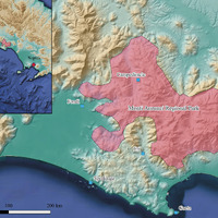 The Monti Aurunci Regional Park with some sites quoted in the text (elaboration E. Vanni) Image preview
 -
 LiDAR image of ‘Le Mura’ site available from the Italian Ministry database (elaboration E. Vanni from http://wms.pcn.minambiente. it/ogc?map=/ms_ogc/WMS_v1.3/servizi-LiDAR/LIDAR_LAZIO.map&service=wms&request=getCapabilities&version=1.3.0)
 -
 The sites investigated by Monti Aurunci Project through excavations and surveys (elaboration E. Vanni)
 -
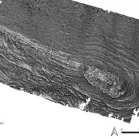 Results of the ‘Blender’ visualization analysis performed in a GIS environment using the RVT visualization plug-in (elaboration G.P. Cirigliano)
 -
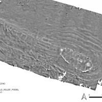 Another example of the visualization analysis results, in this case, a multi-scale relief model, performed in a GIS environment using the RVT visualization plug-in (elaboration G.P. Cirigliano)
 -
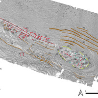 The image allows for the observation and localization of various archaeological structures identified during the analysis and study operations (elaboration G.P. Cirigliano)
 -
 Our LiDAR image processed with the Royal Air Force image taken in 1942 in transparency (in the left box below), showing the tower still standing (elaboration E. Vanni after IGM archive aerial photos from RAF flights year 1942, swipe 13)
 -
 A group of metal finds from Campello. CFM44: Roman shell; CFM152: early medieval necklace element; CFM 121: late medieval buckle; CFM71: modern votive medal (elaboration S. Zocco)
 -
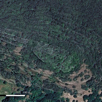 The site of Campello as seen from satellite imagery covered by dense vegetation and the LiDAR RTV Blender in transparency (elaboration E. Vanni)
 -
 A photo of the collapsed southern tower (photo A. Cammisola)
Position: 1064 (31 views)