engDigital outputs derived from non-invasive field methods, including satellite imagery, aerial surveys, LiDAR, and photogrammetry, supporting the identification and documentation of archaeological sites.
During the summers of 2016 and 2017, a series of Unoccupied Aircraft System (UAS, aka drone) missions were flown over the Vulci plateau, an archaeological relevant site near Rome, Italy. The city of Vulci played a prominent role in Italian history and remains a pivotal piece in understanding the physical and social changes that occurred for both Etruscan and Roman cultures between ~9th century BCE and the ~4th century CE. Given the temporal and financial costs of conducting traditional archaeological excavation on a city-wide scale, remote sensing provides a practical and effective method of collecting data that can give archaeologists a crucial perspective on the remains that lie beneath the surface. The UAS flights were conducted using fixed wing drones equipped with optical (RGB), red edge (RE) and near infrared (NIR) sensors. The present dataset provides raw geolocated images and processed geospatial products (orthomosaics, digital elevation models, and reflectance maps) for both survey years and all sensors. These data products are supplemented with information on individual flight dates, areal coverages, image processing workflows, and associated details on spatial accuracy and resolution. These data will expand the potential for new discoveries in this location through direct access to high quality geospatial information.
MedAfriCarbon radiocarbon database and web app are outcomes of the MedAfrica Project —Archaeological deep history and dynamics of Mediterranean Africa, ca. 9600-700 BC. The dataset presented here includes a collection of 1584 calibrated archaeological 14C dates from 1587 samples collected from 368 sites located in Mediterranean Africa (plus some additional dates whose published information is incomplete). The majority of the dates are linked to cultural and environmental variables, notably the presence/absence of different domestic/wild species and specific material culture.
The Villa Arianna is a structural complex located at the archaeological site Stabiae, Italy. The villa is renowned for its frescoes.
The Center for Advanced Spatial Technologies (CAST), University of Arkansas conducted a high density survey of the Villa Arianna in 2010. The survey focused on the garden floor and the adjoining rooms. The original scan files and registered point cloud are available here.
Original scans (unedited) in e57 format (Note: Some are not included in the final registration), transformation matrices for each scan, Registered point cloud in ASCII format. NOTE: A portion of the scans for the House of the Charioteers (those with the Charioteer_ suffix) were aqcuired from a lift boom to provide the necessary vantage points to aqcuire data for some of the structures' tall walls. However, as a result of the windy conditions during the survey and the subsequent movement of the scanner/lift boom, there is movement evidenced in several of the scans. The easiest way to spot this movement is to look for an unnatural ripple or wave pattern in the dataset. This pattern is not always constant and can appear to varying degrees within and between scans. Also, due to insufficient computing power at the time the data were processed, not all of the scans acquired for the House of the Charioteers was registered to one another. The scans that were not included in the final registered dataset have also been archived. Prior to registration 64 of the scans were edited to remove extraneous data. The edited scans were imported into Polyworks IMAlign (and gridded) and then registered. The transformation matrices from the edited scans were exported and are provided here with the original, unedited scans. The final registered point cloud has also been provided as a single ASCII file.
Original scans (unedited) in e57 format (Note: Some are not included in the final registration), transformation matrices for each scan, Registered point cloud in ASCII NOTE: All scans were aqcuired for the Case Giardino from a lift boom which provided the necessary vantage points to aqcuire data for most of the structure's tall walls. However, as a result of the windy conditions during the survey and the subsequent movement of the scanner/lift boom, there is movement evidenced in most of the scans. The easiest way to spot this movement is to look for an unnatural ripple or wave pattern in the dataset. This pattern is not always consistent and can appear to varying degrees within and between sans. Prior to registration all scans were edited to remove extraneous data. The edited scans were imported into Polyworks IMAlign (and gridded) and then registered. Only 31 of the 45 scans were used in the final registered dataset. The transformation matrices from the edited scans were exported and are provided here with the original, unedited scans. The final registered point cloud has also been provided as a single ASCII file.
Original scans (unedited, prior to registration) in e57 format, transformation matrices for each scan, Registered point cloud in ASCII. All scans were aqcuired for the Capitoline temple from a lift boom which provided the necessary vantage points to aqcuire data for most of the strcture's tall walls. However, as a result of the windy conditions during the survey and the subsequent movement of the scanner/lift boom, there is movement evidenced in most of the scans. The easiest way to spot this movement is to look for a ripple or wave pattern that extends how horizontally across the datset (a result of the scanner/left boom moving up-and-down). This pattern is not always consistent and can appear to varying degrees within and between sans. Prior to registration all scans were edited to remove extraneous data. The edited scans were imported into Polyworks IMAlign (and gridded) and then registered. The transformation matrices from the edited scans were exported and are provided here with the original, unedited scans. The final registered point cloud has also been provided as a single ASCII file.
Rilievo delle strutture del criptoportico antico della città di Segni (RM). Il dataset è stato acquisito attraverso una campagna di fotogrammetria terrestre. I dati sono stati rielaborati unendo tecniche di Structure from Motion per ottenere una soluzione fotogrammetrica. I dati sono stati elaborati prevalentemente con software open source e sono conservati in formati aperti: soluzione fotogrammmetrica in file txt utf-8, nuvole di punti in ply binario e immagini in formato jpeg. Il gruppo di lavoro è composto da Emanuel Demetrescu, Adriano Averini, Marco Martuscelli, Emilia Valletta, Augusto Palombini ed Eleonora Scopinaro.
Rilievo della Porta saracena lungo le mura poligonali della città di Segni (RM). Il dataset è stato acquisito attraverso una campagna di fotogrammetria area e terrestre. I dati sono stati rielaborati unendo tecniche di Structure from Motion per ottenere una soluzione fotogrammetrica e Computer Graphic per l’ottimizzazione di geometrie e texture. I dati sono stati elaborati prevalentemente con software open source e sono conservati in formati aperti: soluzione fotogrammmetrica in file txt utf-8, nuvole di punti in ply binario, mesh poligonali con coordinate di mappatura in formato blend, immagini in formato jpeg. Il gruppo di lavoro è composto da Emanuel Demetrescu, Adriano Averini, Marco Martuscelli, Emilia Valletta, Gabriele Ferrazza, Augusto Palombini ed Eleonora Scopinaro.
Rilievo del ninfeo di Quintus Mutius (II-I sec. a.C.) presso il comune di Segni (RM). Il dataset è stato acquisito attraverso una campagna di fotogrammetria terrestre. I dati sono stati rielaborati unendo tecniche di Structure from Motion per ottenere una soluzione fotogrammetrica e Computer Graphic per l’ottimizzazione di geometrie e texture. I dati sono stati elaborati prevalentemente con software open source e sono conservati in formati aperti: soluzione fotogrammmetrica in file txt utf-8, nuvole di punti in ply binario, mesh poligonali con coordinate di mappatura in formato blend, immagini in formato jpeg. Il gruppo di lavoro è composto da Emanuel Demetrescu, Adriano Averini, Marco Martuscelli, Emilia Valletta, Augusto Palombini ed Eleonora Scopinaro.
Rilievo del Museo comunale della città di Segni (RM). Il dataset è stato acquisito attraverso una campagna di fotogrammetria terrestre. I dati sono stati rielaborati unendo tecniche di Structure from Motion per ottenere una soluzione fotogrammetrica. I dati sono stati elaborati prevalentemente con software open source e sono conservati in formati aperti: immagini in formato jpeg. Il gruppo di lavoro è composto da Emanuel Demetrescu, Adriano Averini, Marco Martuscelli, Emilia Valletta, Augusto Palombini ed Eleonora Scopinaro.
Rilievo dell’attuale piazza Felici, area in cui doveva trovarsi il Foro romano dell’antica città di Segni (RM). Il dataset è stato acquisito attraverso una campagna di fotogrammetria terrestre. I dati sono stati rielaborati unendo tecniche di Structure from Motion per ottenere una soluzione fotogrammetrica e Computer Graphic per l’ottimizzazione di geometrie e texture. I dati sono stati elaborati prevalentemente con software open source e sono conservati in formati aperti: soluzione fotogrammmetrica in file txt utf-8, nuvole di punti in ply binario, mesh poligonali con coordinate di mappatura in formato blend, immagini in formato jpeg. Il gruppo di lavoro è composto da Emanuel Demetrescu, Adriano Averini, Marco Martuscelli, Emilia Valletta, Augusto Palombini ed Eleonora Scopinaro.
Rilievo dell’Acropoli della città di Segni (RM). Il dataset è stato acquisito attraverso una campagna di fotogrammetria area e terrestre. I dati sono stati rielaborati unendo tecniche di Structure from Motion per ottenere una soluzione fotogrammetrica e Computer Graphic per l’ottimizzazione di geometrie e texture. I dati sono stati elaborati prevalentemente con software open source e sono conservati in formati aperti: soluzione fotogrammmetrica in file txt utf-8, nuvole di punti in ply binario, mesh poligonali con coordinate di mappatura in formato blend, immagini in formato jpeg. Il gruppo di lavoro è composto da Emanuel Demetrescu, Adriano Averini, Marco Martuscelli, Emilia Valletta, Gabriele Ferrazza, Augusto Palombini ed Eleonora Scopinaro.
RiPROCESS is the RIEGL software package for kinematic LiDAR data processing. It is designed for managing, processing, analyzing, and visualizing data acquired with airborne laser scanning systems (ALS systems), unmanned laser scanning systems (ULS systems), and mobile laser scanning systems (MLS systems) based on RIEGL Laser Scanners
Rilievo digitale della piazza lastricata del suburbio di Nora (Pula, CA), area pubblica della città, risalente all'età imperiale. Il dataset, funzionale allo studio delle strutture conservate, alla loro ricostruzione virtuale, alla valorizzazione e conservazione del complesso, è stato acquisito sia con sensori passivi (fotocamera digitale).
Rilievo digitale della necropoli fenicia e punica nord-occidentale di Nora (Pula, CA), spazio funerario della città antica sfruttato sin dalla prima fase di frequentazione fenicia (VIII sec. a.C.) e per tutta l'età punica (fine VI-III sec. a.C.). Il dataset, funzionale allo studio delle strutture conservate, alla loro ricostruzione virtuale, alla valorizzazione e conservazione del complesso, è stato acquisito sia con sensori attivi (laserscanner, stazione totale) che passivi (reflex, fotocamera stereoscopica 3D 360).
Rilievo digitale dell'edificio a est del foro di Nora (Pula, CA), complesso di carattere abitativo e produttivo risalente alla media età imperiale romana. Il dataset, funzionale allo studio delle strutture conservate, alla loro ricostruzione virtuale, alla valorizzazione e conservazione del complesso, è stato acquisito sia con sensori attivi (laserscanner, stazione totale) che passivi (reflex full frame, fotocamera stereoscopica 3D 360).
Rilievo digitale del santuario di Eshmun/Esculapio di Nora (Pula, CA), complesso di culto frequentato sin dall'età fenicia e sino alla tarda età romana. Il dataset, funzionale allo studio delle strutture conservate, alla loro ricostruzione virtuale, alla valorizzazione e conservazione del complesso, è stato acquisito sia con sensori attivi (laserscanner, stazione totale) che passivi (fotocamera digitale, fotocamera stereoscopica 3D 360).
Two-dimensional (2D) electrical imaging surveys are now widely used to map areas of moderately complex geology where conventional 1D resistivity sounding and profiling techniques are inadequate. The results from such surveys are usually plotted in the form of a pseudosection (Figure 1a) which gives an approximate but distorted picture of the subsurface geology.
Reflexw is one of the world's most popular geophysical near surface processing and interpretation packages with more than 2000 sold licences. The software covers the complete range of wave data (seismic, GPR, ultrasound) and the different geometry assemblings (surface reflection and refraction, borehole crosshole and tomography and combination of borehole and surface measurements).
RECONSTRUCTOR. THE POWERFUL PROCESSING SOFTWARE FOR LIDAR DATA. A multi-sensor and multi-resolution software used worldwide to manage 3D point clouds and images coming from different lidar and imaging platforms.
- Processing of point clouds and raw data from several laser scanners (terrestrial, handheld, mobile, airborne)
- Integration of point cloud models from UAV and photogrammetric surveys
- Automatic target-less registration of 3D scans from various instruments
- Colourization of point clouds with RGB images from high-res cameras
- Creation of mesh models - Computation of volumes, areas, profiles, contour lines
- Direct export of outputs and formats to the main third-party software (e.g ReCap Pro)
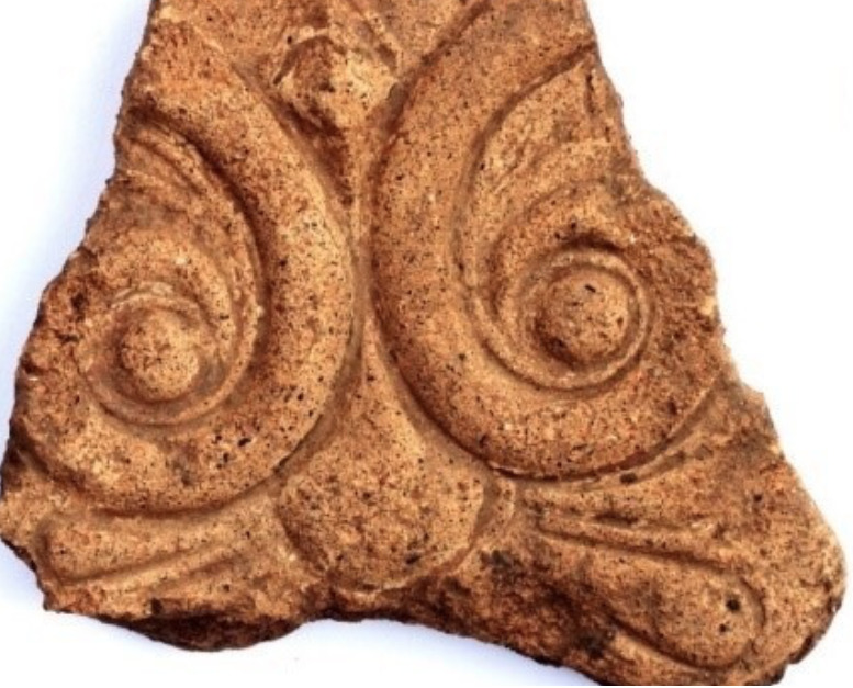
This contribute aims to provide new insight on the production and circulation of full-figure architectural terracotta images adorning temples, namely fictiles, in northern Etruria. The investigation focuses on the recent discovering of a relevant corpus of architectural terracottas in Populonia, emerged during the excavation in La Casaccia locality, on the eastern slopes of Poggio del Castello (Baratti, Livorno, Tuscany). The review of the typological study and the archaeometric analysis on a selection of representative antefixes and relief plaques disclosed a complex scenario revealing the presence of both local and imported fictiles. Future and already planned investigations of architectural terracottas from Volterra promise to enlarge the frame on the circulation of imported fictiles from the nearby Campanian areas, redrawing the dual interpretation of mobility of goods vs mobility of men for decorating public buildings in northern Etruria.
Pozzuoli Flavian Amphitheater, East-3 cistern (Pozzuoli, Naples, Italy). Preliminary confined space model. Data acquisition on Feb 28, 2023 with Apple iPhone 14 Pro, IOS V16.2, 256 GB of RAM, and the Scaniverse V2.1.4 application, with scanning in Area mode and processing in Area mode. No post-processing on other devices. Credits: Graziano W. Ferrari (scanning), Ruggero Morichi (technical consultancy), Giovanni Grasso (operations support).
Photogrammetric 3D model of the main quarry in Porto Miggiano (Le). The digital survey was performed in 2022 using an unmanned aerial vehicle (UAV) DJI Mavic 2 Pro equipped with a high-resolution (20 MP) RGB camera. The photo data set has been processed within Agisoft Metashape Professional ® Professional software that allowed to obtain 3D spatial data and ortophoto.
Campanian Augustan Aqueduct at Parco dello Sport (Bagnoli, Naples, Italy), adit R9. Preliminary confined space model. Data acquisition on Aug 24, 2023 with Apple iPhone 14 Pro, IOS V16.2, 256 GB of RAM, and the Scaniverse V2.1.4 application, with scanning in Area mode and processing in Area mode. No post-processing on other devices. Credits: Graziano W. Ferrari (scanning), Raffaella Lamagna (operations support).
Campanian Augustan Aqueduct at Parco dello Sport (Bagnoli, Naples, Italy), channel junction between R7 and R8 adits. Preliminary confined space model. Data acquisition on Aug 24, 2023 with Apple iPhone 14 Pro, IOS V16.2, 256 GB of RAM, and the Scaniverse V2.1.4 application, with scanning in Area mode and processing in Area mode. No post-processing on other devices. Credits: Graziano W. Ferrari (scanning), Raffaella Lamagna (operations support).
È stato eseguito il rilievo fotogrammetrico di un trapezoforo in marmo, proveniente dal porto fluviale di Seripola (VT), attualmente conservato nel Museo Civico Archeologico di Orte. Il trapezoforo, rinvenuto nel settore III del porto fluviale, presenta le sembianza di un grifo, con le zampe e il corpo leonini e le ali di aquila. Il reperto (dimensioni 69x34x17 cm) è mancate della zampa anteriore sinistra, mentre la destra è in parte fratturata. Il dataset è uno strumento utile allo studio, alla progettazione degli interventi di restauro e alla valorizzazione. Il dataset è stato acquisito attraverso una campagna di fotogrammetria con sensori passivi (reflex full frame) e i dati sono stati elaborati con software Structure from Motion (SfM). Le immagini acquisite sono state calibrate e salvate in formato jpg 8 bit al massimo della qualità, utilizzate per l'elaborazione con software SfM. I dati sono conservati in formati aperti: immagini in formato jpg, soluzione fotogrammetrica in xml, nuvola di punti in ply, mesh poligonale con texture in formato obj. Il gruppo di lavoro è composto da Bianca Magliocchetti, Emanuel Demetrescu, Simone Berto ed Eleonora Scopinaro.
È stato eseguito il rilievo fotogrammetrico di una testa di una figura femminile in marmo, proveniente dal porto fluviale di Seripola (VT), attualmente conservata nel Museo Civico Archeologico di Orte. La testa, di dimensioni 21x13x8,5 cm, indossa una corona di fiori e foglie tra i capelli e presenta una scriminatura centrale con alcune ciocche ondulate che ricadono lateralmente. Il dataset è uno strumento utile allo studio, alla progettazione degli interventi di restauro e alla valorizzazione. Il dataset è stato acquisito attraverso una campagna di fotogrammetria con sensori passivi (reflex full frame) e i dati sono stati elaborati con il software Structure from Motion (SfM). Le immagini acquisite sono state calibrate e salvate in formato jpg 8 bit al massimo della qualità, utilizzate per l'elaborazione con il software SfM. I dati sono conservati in formati aperti: immagini in formato jpg, soluzione fotogrammetrica in xml, nuvola di punti in ply, mesh poligonale con texture in formato obj. Il gruppo di lavoro è composto da Bianca Magliocchetti, Emanuel Demetrescu, Simone Berto ed Eleonora Scopinaro.
È stato eseguito il rilievo fotogrammetrico di una lastra marmorea, proveniente dal porto fluviale di Seripola (VT), attualmente conservata nel Museo Civico Archeologico di Orte. La lastra presenta un bassorilievo di una figura maschile su un'imbarcazione a remi di modeste dimensioni. Il reperto è diviso in due frammenti, ricongiunti, di dimensioni 49x44x9 cm, e costituisce l'angolo inferiore sinistro della lastra. Il dataset è uno strumento utile allo studio, alla progettazione degli interventi di restauro e alla valorizzazione. Il dataset è stato acquisito attraverso una campagna di fotogrammetria con sensori passivi (reflex full frame) e i dati sono stati elaborati con il software Structure from Motion (SfM). Le immagini acquisite sono state calibrate e salvate in formato jpg 8 bit al massimo della qualità, utilizzate per l'elaborazione con software SfM. I dati sono conservati in formati aperti: immagini in formato jpg, soluzione fotogrammetrica in xml, nuvola di punti in ply, mesh poligonale con texture in formato obj. Il gruppo di lavoro è composto da Bianca Magliocchetti, Emanuel Demetrescu, Simone Berto ed Eleonora Scopinaro.
È stato eseguito il rilievo fotogrammetrico di un frammento di busto in marmo di una figura maschile, proveniente dal porto fluviale di Seripola (VT), attualmente conservato nel Museo Civico Archeologico di Orte. Il frammento, rinvenuto nel settore IV del porto fluviale, rappresenta parte del busto di una scultura marmorea a tutto tondo raffigurante un personaggio maschile giovane. Privo della testa e delle braccia, si interrompe all'inizio dell'addome, le cui dimensioni sono 10,3x13x7 cm. Il dataset è uno strumento utile allo studio, alla progettazione degli interventi di restauro e alla valorizzazione. Il dataset è stato acquisito attraverso una campagna di fotogrammetria con sensori passivi (reflex full frame) e i dati sono stati elaborati con il software Structure from Motion (SfM). Le immagini acquisite sono state calibrate e salvate in formato jpg 8 bit al massimo della qualità, utilizzate per l'elaborazione con software SfM. I dati sono conservati in formati aperti: immagini in formato jpg, soluzione fotogrammetrica in xml, nuvola di punti in ply, mesh poligonale con texture in formato obj. Il gruppo di lavoro è composto da Bianca Magliocchetti, Emanuel Demetrescu, Simone Berto ed Eleonora Scopinaro.
The Visual Computing Lab of ISTI-CNR was involved in the setup of the temporary exhibition Il viaggio oltre la vita. Gli Etruschi e l'aldilà tra capolavori e realtà virtuale, focused on the depiction of the afterlife by the Etruscan civilization. The curators of the exhibition asked for a 3D model of the famous "Sarcofago Degli Sposi" (Sarcophagus of the Spouses) from the National Etruscan Museum of Villa Giulia, in Rome; the model should have been good enough for the creation of a presentation video. On-the-field work lasted around one day (plus 2-3 hours for the photos). We used a Minolta Vivid 910 triangulation laser scanner to digitize the shape of the artwork. We took 352 scans, for a total of 3.1 GB of raw data. The scans have been then aligned and merged in a single triangulated surface. The final model, generated at a resolution of 0.5mm was composed of 60 million triangles. The geometry was then color-mapped using the photos taken at the museum. As the intended use for the 3D model was a rendered video, we tested it inside Blender.
All the data processing (alignment, cleaning, merging, color mapping) was carried out using MeshLab, an open-source 3D models visualization and processing tool, developed by the Visual Computing Lab ISTI-CNR. The 3D model of the Sarcophagus has been also made available for online browsing. The viewer, accessible from the link on the left, let the user explore the complex object using a simple interface.
The viewer has been created using 3DHOP, an open-source tool for the onlione publication of high-resolution 3D models, developed by the Visual Computing Lab ISTI-CNR.
MicMac is a free open-source (Cecill-B licence) photogrammetric suite that can be used in a variety of 3D reconstruction scenarios. In aims mainly at professionnal or academic users but constant efforts are made to make it more accessible to the general public.
Il dataset contiene due rilievi fotogrammetrici di dettaglio di monumenti conservati sul sito dell'antica città etrusca di Marzabotto. Il rilievo di questi monumenti costituisce una importante risorsa per la valorizzazione degli stessi e un punto di partenza imperscindibile per la modellazione e il loro restauro virtuale.
Leica Cyclone 3DR is a seamless extension of the Cyclone product family which works hand in hand to take users from field data collection with Cyclone FIELD 360 through registration in Cyclone REGISTER 360 and deliverable creation in Cyclone 3DR.
The model represents the shipwreck Grado I in situ, both the woodel elements of the ship, both the amphoras of the cargo. The original disposition of the shipwreck model has been obtained from the documentation realized during the excavation processes from 1990 to 1999.
Global Mapper® is a cutting-edge GIS software that provides both novice and experienced geospatial professionals with a comprehensive array of spatial data processing tools, with access to an unparalleled variety of data formats. Global Mapper's intuitive user interface and logical layout help smooth the learning curve and ensure that users will be up-and-running in no time. Organizations of any size quickly see a significant return on investment brought about by efficient data processing, accurate map creation, and optimized spatial data management.
Geomagic Wrap delivers a new and improved 3D scan-to-model workflow. From expanded file format support to manipulating texture maps for bringing your printed parts to life, the 3D scan data toolbox of Geomagic Wrap provides a wealth of possibilities.
ERTLab Studio è il nostro software di modellazione e inversione più avanzato per tutte le esigenze di resistività elettrica tomografica e polarizzazione indotta (ERT) 2D, 3D o 4D.
Una versione completamente rinnovata con una nuova interfaccia grafica in grado di gestire l'intera campagna di rilievo (dalla generazione della geometria degli elettrodi alla presentazione dei dati elaborati) in un unico ambiente di lavoro 3D integrato.
Tutti i singoli moduli ERT delle versioni precedenti sono ora incorporati in un ambiente grafico 3D completo. Ciò offre all'utente il pieno controllo del flusso di lavoro del progetto in un'unica applicazione.
In particolare, possono essere generati oggetti grafici tridimensionali (cubi, sfere, blocchi) che permettono una più chiara orientazione del volume di resistività rappresentato oltre a poter importare file .dxf, immagini raster e nuvole di punti.
Survey and creation of a digital replica of the interior of the Tomb of Reliefs located in the Banditaccia Necropolis in Cerveteri (RM). It is the only Etruscan tomb (4th BC) decorated with stucco reliefs, unusual compared to the usual frescoes. The dataset, because of its high resolution and accuracy, is a useful tool for study, restoration planning and enhancement of an environment normally closed to the public for conservation reasons. The dataset was acquired with active (Faro laser scanner) and passive (full-frame SLR) sensors through a spherical photogrammetry campaign. The data were reprocessed by combining Structure from Motion techniques to obtain a photogrammetric solution and Computer Graphic for colour correction (with digital painting tools) and geometry and texture optimization. The data mainly concern the 3D domain, have been reprocessed primarily with open source software and are stored in open formats: photogrammetric solution in utf-8 txt files, point clouds in binary ply, polygon meshes with mapping coordinates in blend format, images in jpeg format. The working group consists of researchers from CNR-ISPC: Enzo d'Annibale, Emanuel Demetrescu, Daniele Ferdani.
This data set contains a number of digital models produced via 3D photogrammetric scanning as part of the SCAN4RECO project, funded by the European Horizon'2020 program. Scanning and processing of models was done with Pix4D Mapper and Autodesk ReMake software from images captured with Canon 5DS camera in 50 Megapixel image resolution. Example objects include Byzantine icons painted on wood, oil paintings on canvas and painted Venetian carnival paper masks.
Second version of the data set includes historical icons of Saint DImitrios and Saint Archangel Michael, an icon of Saint Mary painted specially for testing SCAN4RECO technologies, as well as models of an original high-relief sculpture from OPD and of its 3D printed copy (made by Fraunhofer-IGD and hand painted by RFSAT).
Digital model of the extra-urban sanctuary of the city of Tusculum (Current status, 2019). The model describes the current state of the complex from the architectural survey of Quilici L., Quilici Gigli S. (1995) and Francesco De Stefano. It has been made by Autodesk Revit 2020, and simplified in Rhinoceros 4.0. Credits: José María Guerrero Vega (modeling); Antonio Pizzo (archaeological supervision).
Nell’ambito del progetto e-Archeo, gestito dalla società ALES, si è svolta l’attività di rilievo fotogrammetrico di dettaglio della villa romana di Desenzano, con l’obiettivo di creare un’importante risorsa per la valorizzazione e al contempo di determinare un punto di partenza per l’elaborazione delle piante di fase e per la ricostruzione e modellazione 3D dell’edificio.
Per il rilievo della villa si è proceduto con l’acquisizione del dataset delle immagini tramite drone (Mavic 2 pro della DJI), ottenendo fotogrammi: nadirali, frontali e obliqui. Nel contempo è stata registrata la posizione dei punti di appoggio e di controllo, da usare nell’elaborazione fotogrammetrica per georiferire i rilievi.
Per la fase successiva di acquisizione ed elaborazione dei dati del progetto è stato utilizzato il software Agisoft Metashape (Structure-from-Motion). In seguito all’allineamento e all’ottimizzazione delle camere è stata generata la nuvola di punti densa, il meshing delle superfici e la texturizzazione del modello 3D. Dal set di dati ottenuto è stato possibile ricavare l’ortofoto dell’area della villa e di dettaglio dei settori A e B e il DTM dell’area della villa, quest’ultimo utile alla ricostruzione del paesaggio antico.
Gruppo di lavoro: F. Soriano e A. Zemignani.
La collezione è composta da sei manoscritti custoditi presso la Biblioteca Augusta di Perugia, databili ai secoli XIII e XIV. Di questi, quattro sono di ambito umbro, uno è di provenienza bolognese e uno è riconducibile ad area toscana. Nel 2011 i codici sono stati oggetto di indagini diagnostiche non invasive eseguite dal Centro di Eccellenza SMAArt dell’Università di Perugia e dall’Istituto di Scienze e Tecnologie Molecolari del CNR, che hanno restituito elementi utili a ricostruire i materiali impiegati, le tecniche esecutive, la distinzione delle mani tra i diversi miniatori impegnati nella decorazione dei volumi nonché la loro localizzazione.
Collezione di 18 modelli 3D navigabili della collezione di maquettes del Museo Egizio di Torino.
Questi artefatti, fabbricati in Egitto nell’Ottocento e arrivati al Museo nel 1823, rappresentano monumenti dell'Egitto e della Nubia: templi, portali e un obelisco.
Alcuni di questi monumenti hanno subito uno spostamento a seguito della ‘Campagna Internazionale UNESCO per il salvataggio dei templi della Nubia’ durante gli anni Sessanta.
CloudCompare is a 3D point cloud (and triangular mesh) processing software. It has been originally designed to perform comparison between two dense 3D points clouds (such as the ones acquired with a laser scanner) or between a point cloud and a triangular mesh. It relies on a specific octree structure dedicated to this task. Afterwards, it has been extended to a more generic point cloud processing software, including many advanced algorithms (registration, resampling, color/normal/scalar fields handling, statistics computation, sensor management, interactive or automatic segmentation, display enhancement, etc.).
The study was undertaken in six medieval-like model glass samples UG (unaltered glass), MAK, MAR, MTA, MTB and MTN subjected to various environmental and atmospheric conditions in order to generate alteration layers of different characteristics. A potash-lime silicate glass, with composition similar to that of medieval glasses, was melted at 1400 °C during two hours, poured in a brass mould of rectangular cross section and annealed at 650 °C. The resulting glass ingot was cut in slices of around 10×10×2 mm3 and then polished using emery paper and an aqueous suspension of cerium oxide to obtain optical quality surfaces. Alteration of the glass slices was conducted by exposure to five different laboratory corrosion tests: SO2 corrosion for MAK sample, synthetic river water degradation for MAR, and degradation due to acid, basic and neutral medium for MTA, MTB and MTN, respectively. This dataset consists of images of the samples; Laser-induced Breakdown Spectrocopy (LIBS) spectra; Laser-induced Fluorescence (LIF) spectra; Optical Microscopy (OM); FT-Raman spectroscopy and Multi-Photon Excitation Fluorescence (MPEF) signals obtained with a Nonlinear optical microscopy (NLOM). This information allows characterizing the composition of both body glass and determining the thickness of the degradation layer. Images are presented in JPG. All spectra are presented in cvs format, in a single page.
Rilievo con laser scanner del Tumulo Campana, il monumento di maggior impatto visivo della Necropoli di Monte Abatone, con il suo diametro di oltre trenta metri. Il dataset comprende le nuvole di punti dell’intero tumulo, sia dell’esterno che delle camere interne ipogee, realizzate nell’anno 2021 da parte della Cattedra di Etruscologia e Antichità Italiche (prof. Fernando Gilotta) del Dipartimento di Lettere e Beni Culturali e della Cattedra di Disegno (prof.ssa A. Cirafici) del Dipartimento di Architettura e Disegno Industriale dell’Università degli Studi della Campania “L. Vanvitelli”. L’acquisizione e l’elaborazione (prof. P. Argenziano, prof.ssa A. Avella, arch. T. Patriziano), sono suddivisi in nuvola di punti in formato .e57 e mesh poligonale in formato .ply. Il dataset, per la sua risoluzione e accuratezza, è uno strumento utile allo studio e alla valorizzazione di un monumento che sebbene sia conosciuto dalla metà del 1800, e giunto a noi con controverse fortune dei corredi delle camere sepolcrali, non aveva ancora ricevuto un approfondimento di studi sulla struttura, sia da un punto di vista materiale che architettonico, inserendolo nel contesto territoriale di appartenenza. Inoltre è un mezzo di valorizzazione poiché il monumento non è immediatamente accessibile al pubblico. Il dataset è stato acquisito con laser scanner Leica BLK360 e le nuvole sono state rielaborate con software Leica Cyclone.
Il gruppo di lavoro è composto da ricercatori e professionisti del Dipartimento di Lettere e Beni Culturali e di Architettura e Disegno industriale dell’Università degli Studi della Campania “L. Vanvitelli” coordinati dal prof. F. Gilotta e prof.ssa A. Cirafici.
Rilievo con laser scanner dell’area di scavo indagata negli anni 2018-2019 nella Necropoli di Monte Abatone nei pressi del monumentale Tumulo Campana. La campagna di scavo è condotta dalle Università della Campania “L. Vanvitelli”, della Tuscia e di Bonn e ha riportato alla luce tombe e tamburi di tumuli finora sconosciuti permettendo la ricostruzione del paesaggio funerario antico. Il dataset comprende le nuvole di punti dell’intera area di scavo, sia dell’esterno che delle camere tombe ipogee, realizzate nell’anno 2019 da parte della Cattedra di Etruscologia e Antichità Italiche (prof. Fernando Gilotta) del Dipartimento di Lettere e Beni Culturali ed elaborate con la collaborazione della Cattedra di Disegno (prof.ssa A. Cirafici) del Dipartimento di Architettura e Disegno Industriale dell’Università degli Studi della Campania “L. Vanvitelli”. L’acquisizione (dr. C. Rizzo, dr. T. D’Anna) e l’elaborazione (prof. P. Argenziano, prof.ssa A. Avella, arch. T. Patriziano), sono suddivisi in aree esterne e ambienti ipogei in nuvola di punti in formato .e57 e mesh poligonale in formato .ply. Il dataset, per la sua risoluzione e accuratezza, è uno strumento utile allo studio e alla valorizzazione di un’area sepolcrale che ogni anno è interrata per motivi di conservazione e sicurezza, permettendo di inserirla nel contesto territoriale di appartenenza.
Il dataset è stato acquisito con laser scanner Leica BLK360 e le nuvole sono state rielaborate con software Leica Cyclone.
Il gruppo di lavoro è composto da ricercatori e professionisti del Dipartimento di Lettere e Beni Culturali e di Architettura e Disegno industriale dell’Università degli Studi della Campania “L. Vanvitelli” coordinati dal prof. F. Gilotta e prof.ssa A. Cirafici.
Installazione accessibile con TUI (Tangible User Interface) dal titolo “La Tomba-Casa degli Etruschi”, realizzata secondo i principi dell’Universal Design. Destinata alla Sala Mengarelli di Cerveteri, e-Archeo Tattile ha l’obiettivo di coinvolgere il visitatore invitandolo a interagire con alcuni contesti riprodotti tridimensionalmente e materialmente, che servono come tramite per una narrazione audiovisiva su schermo sottotitolata e in lingua dei segni (LIS e IS). I temi proposti nella TUI riguardano la necropoli di Monte Abatone a Cerveteri, con la sua varia tipologia di tombe simili a case. Per la prima volta la necropoli di Monte Abatone viene presentata al pubblico sebbene in forma virtuale. Non è infatti possibile visitarla nella realtà dal momento che lo scavo archeologico, ancora in corso, viene ricoperto ogni anno per motivi di conservazione.
Viene qui pubblicato il progetto, le linee guida metodologiche e gli output multimediali. Il gruppo di lavoro è multidisciplinare ed include istituzioni di ricerca, esperti di accessibilità e industrie creative.
I dati possono essere scaricati dagli utenti, in base al loro livello di accesso al sistema in formati raster e vettoriali aperti (Json, KML, SHP, Geotiff, CSV, Geojson). L’utente ha la possibilità di stampare tavole tematiche relative ai layers di interesse che sono stati selezionati nella mappa, effettuare misurazioni e ricerche.
Autodesk ReCap Pro software helps designers and engineers capture high-quality, detailed models of real-world assets. Use ReCap Pro to:
Create 3D models from photographs or laser scans to transform real-world objects and environments into digital assets
Deliver a point cloud or mesh and collaborate across teams with existing conditions and as-built assets
Leverage cloud-based workflows to efficiently update, extract features, and manage files in the cloud
In addition to a subscription, you need Autodesk Flex tokens to process ReCap data (cloud) services such as Scan to Mesh and ReCap Photo projects. Learn more.
Application of Close-Range SfM Photogrammetry on three bases of Etruscan Bronze Candelabra from Spina Necropolises.
This dataset contains the photogrammetry made 3D models of three Etruscan Bronze Candelabra found at Spina, dated to the 4th cent. BC, kept in the Archaeological Museum of Ferrara.
The models were made through Agisoft Metashape from previously taken RAW photos, at the National Archaeological Museum of Ferrara, for master thesis purposes. Some minor issues of the meshes were solved using Blender before texturing the models.
The folders are divided according to the tombs of provenance of the candelabra (T. 545, T. 1122, T. Unknown) and every folder contain: The OBJ, The texture, An additional folder with the reports generated from Agisoft Metashape.
Applanix POSPac UAV®, now with Applanix POSPac® Trimble Post-Processed CenterPoint® RTX™ (PP-RTX®), is a next generation, industry-leading software for Direct Georeferencing of UAV/Drone mapping sensors using GNSS and inertial technology. It is tailored to the UAV/Drone market supporting Trimble APX products. This smart software solution achieves both maximum accuracy and maximum efficiency for Direct Georeferencing. Compared to Applanix POSPac MMS® it is a smaller software package focussing on UAV application.
Agisoft Metashape is a stand-alone software product that performs photogrammetric processing of digital images and generates 3D spatial data to be used in GIS applications, cultural heritage documentation, and visual effects production as well as for indirect measurements of objects of various scales.
è il software di fotogrammetria sviluppato da 3Dflow
per ricostruire modelli 3D da fotografie, per affrontare qualunque sfida di ricostruzione 3D e scansione. Automaticamente.
Non importa quale sensore fotografico, drone o laser scanner
stai utilizzando.
3D Survey Collection - shortly 3DSC, an addon for Blender
Hello there! I’m 3D Survey Collection, an open source add-on (GPL3) for Blender that simplifies the tasks involved in the management and optimization of the archaeological and architectonic 3D record
I can transform an extensive survey of an archaeological excavation into a real-time oriented asset that can be used inside a Game Engine to create Open World experiences (Unreal, Unity, Godot).
I can:
- dramatically enhance the visual quality of a photogrammetric survey through interactive tools (paint from cameras, color correction)
integrate different surveys made in different light conditions (color correction, texture patcher)
- segment big models in tiles and create automatically level of details
manage 3D scene complexity and model a virtual reconstruction hypothesis
manage georeferenced GPS and Total station data points
- import and export 3D models with customized tools
I am under constant development by Emanuel Demetrescu during his research activities at the CNR-ISPC (Italian National Council for Research, Institute of Heritage Science) (former CNR-ITABC) within the DHILab.
I need constant improvements and beta testing in real projects, so, developers out there, email my creator at emanuel.demetrescu at cnr dot it or simoneberto at cnr dot it and contribute :-)
3D reconstrutive model of the bronze male statue known as the "Hellenistic Prince" or "Lucius Aemilius Paullus, from Punta del Serrone (Brindisi, Italy); 2nd century BC; current location: Brindisi, Archaeological Museum "F. Ribezzo". Credits: graphic rendering: Fabiola Malinconico, Cultural Heritage Department, University of Salento; 3D Laser Scans: Adriana Bandiera, SIBA- University of Salento; creative modeling: Matteo Toriello, 3D Box Creative Lab; rendering: Giuliano De Felice, Università di Bari; scientific research and design: Katia Mannino, Cultural Heritage Department, University of Salento.
3D reconstructive model of the bronze statue of the little girl, from Punta del Serrone (Brindisi, Italy); 2nd century AD; current location: Brindisi, Archaeological Museum "F. Ribezzo". Credits: graphic rendering: Fabiola Malinconico, Cultural Heritage Department, University of Salento; 3D Laser Scans: Adriana Bandiera, SIBA- University of Salento; creative modeling: Matteo Toriello, 3D Box Creative Lab; rendering: Giuliano De Felice, Università di Bari; scientific research and design: Katia Mannino, Cultural Heritage Department, University of Salento.
3D photorealistic model of the centurpine vase. The vase was acquired with a structured light system (Cronos Dual by Open Technologies - Faro rebranded) and processed with Optical RevEng Pro. The vase was acquired using turntable synchronized with the acquisition software, setting with a fixed rotation angle of 32 °. 44 scans were acquired for the vase. Credits: Emanuela Faresin.
3D photorealistic model of the centurpine vase. The vase was acquired with a structured light system (Cronos Dual by Open Technologies - Faro rebranded) and processed with Optical RevEng Pro. The vase was acquired using turntable synchronized with the acquisition software, setting with a fixed rotation angle of 32 °. 33 scans were acquired for the lid. Credits: Emanuela Faresin.
3D model of Tomba di San Giusto 2, necropoli di San Giusto, Volterra (PI). The simplified Virtual Model has been conceived for a VR application and realized by photogrammetry with Agisoft Metashape 1.6.6. Credits: Emanuele Taccola
3D model of Tomba dei Marmini 1, necropoli del Portone, Volterra (PI). The simplified Virtual Model has been conceived for a VR application and realized by photogrammetry with Agisoft Metashape 1.6.6. Credits: Emanuele Taccola
3D model of the Tomb 27 of Colle Vaccaro. The lowpoly virtual model has been generated from a highpoly version realized by Agisoft Metashape. The geometry was processed in Meshlab, texture baking (diffuse and normal map) was carried out in Blender.
Part of the photogrammetric model of the portal in Corte dei Pali già Testori (Cannaregio 3837, Venice, Italy). Photos taken with Canon EOS 100D; topography Leica Disto S910; processing Agisoft Metashape. Credits: Eleonora Delpozzo.
Photogrammetric model of San Vidal bell tower base, visible side. Current location: Campiello San Vidal (Venice, Italy). Photos taken with Canon EOS 100D; topography Leica Disto S910; processing Agisoft Metashape. Credits: Eleonora Delpozzo
Ancona, Museo Archeologico Nazionale delle Marche, inv. 27416: red-figure skyphos from tomb 219 Davanzali, Courtesy of Ministero della Cultura - Direzione Regionale Musei Marche. The 3D model was authored using SfM digital photogrammetric techniques after color calibration and color profile checking for 40 pictures of the item.
3D model of Ipogeo di Torricchi, necropoli di Ulimeto, Volterra (PI). The simplified Virtual Model has been conceived for a VR application and realized by photogrammetry with Agisoft Metashape 1.6.6. Credits: Emanuele Taccola
3D model of a frontal bone of a male adult skeletal individual from the KR-N1 necropolis (Dhofar, Oman); current location: Museum of Frankincense Land of Salalah (inv. IQM18B.US124.HB1). The 3D model has been realised applying the 3D photogrammetric reconstruction, using the software Agisoft Metashape Professional 1.7. Credits: Matteo Vangeli (modeling); Gabriele Gattiglia, Filippo Sala (digital supervision); Silvia Lischi (archaeological supervision).
3D model of permanent first upper left incisor of an adult skeletal individual from the KR-N1 necropolis (Dhofar, Oman); current location: Museum of Frankincense Land of Salalah (inv. IQM18B.US124.HB3). The 3D model has been realised applying the 3D photogrammetric reconstruction, using the software Agisoft Metashape Professional 1.7. Credits: Matteo Vangeli (modeling); Gabriele Gattiglia, Filippo Sala (digital supervision); Silvia Lischi (archaeological supervision).
3D model of calcific lymph node of a skeletal individual from the KR-N1 necropolis (Dhofar, Oman); current location: Museum of Frankincense Land of Salalah (inv. IQM18B.US124.HB51). The 3D model has been realised applying the 3D photogrammetric reconstruction, using the software Agisoft Metashape Professional 1.7. Credits: Matteo Vangeli (modeling); Gabriele Gattiglia, Filippo Sala (digital supervision); Silvia Lischi (archaeological supervision).
3D model of amphora Kamares style (Middle Minoan period, 1950-1700 b.C.), from the Palace of Phaistos (Crete) (inv. F347); current location: Archaeological Museum of Herakleion (inv. HM10551). The simplified Virtual Model has been conceived for gaming and realized by Rhinoceros 7.0, starting from the rotation of a 2D profile of the amphora and adding the nautilus and double spiral decoration vectorialized from a photograph of the original. Credits: Graziana D’Agostino (modeling); Francesca Buscemi, Marianna Figuera (archaeological supervision).
3D model of a right clavicle of a sub-adult skeletal individual from the KR-N1 necropolis (Dhofar, Oman); current location: Museum of Frankincense Land of Salalah (inv. IQM18B.US124.HB51). The 3D model has been realised applying the 3D photogrammetric reconstruction, using the software Agisoft Metashape Professional 1.7. Credits: Matteo Vangeli (modeling); Gabriele Gattiglia, Filippo Sala (digital supervision); Silvia Lischi (archaeological supervision).
3D model of of a portion of the Severian architectural complex carried out through image-based-modelling photogrammetry techniques based on Structure From Motion performed on Agisof Metashape software
3D model of a pendant shaped like an oinochoe before restoration (inv. T27 C.V.71); current location Archaeological Museum of Ascoli Piceno (Marche, Italy). The lowpoly virtual model has been generated from a highpoly version realized by Agisoft Metashape. The geometry was processed in Meshlab, texture baking (diffuse and normal maps) was carried out in Blender.
3D model of a pendant shaped like an oinochoe after restoration (inv. T27 C.V.71); current location Archaeological Museum of Ascoli Piceno (Marche, Italy). The lowpoly virtual model has been generated from a highpoly version realized by Agisoft Metashape. The geometry was processed in Meshlab, texture baking (diffuse and normal maps) was carried out in Blender.