L'International Etruscan Sigla Project (IESP) è stato avviato nel 2010 dalla Florida State University e dall’Università degli Studi di Milano. E' dedicato allo studio e all'analisi dei segni iscritti non verbali (sigla) presenti su molteplici categorie di manufatti della civiltà etrusca.
IDEA is a non-profit organization born from EAGLE (Europeana network of Ancient Greek and Latin Epigraphy). The purpose of EAGLE was to gather and catalogue more than 1.500.000 images and other digital objects related to hundreds of thousands of greek and roman inscriptions accompanied by basic information, often also in english and in other modern languages. All this can be found in a single and easy-to-search database.
IDEA promotes the use of advanced methodologies in the research, study, enhancement, and publication of “written monuments,” beginning with those of antiquity, in order to increase knowledge of them at multiple levels of expertise, from that of specialists to that of the occasional tourist.
The organisation is open to individuals, institutions, public and private organisations, societies and other associations.
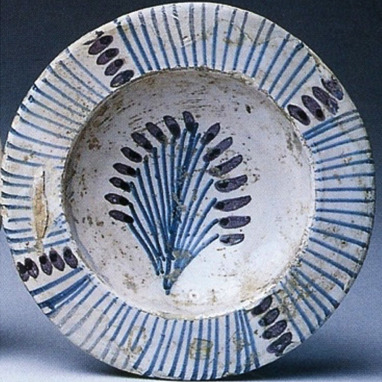
Questo progetto di ricerca nasce nell’ambito del programma di dottorato nazionale di Artificial Intelligence for Society, bandito dal Dipartimento di Informatica dell’Università di Pisa. Questa proposta di ricerca utilizza il deep learning per accentuare il valore di una già riconosciuta risorsa territoriale quali sono le ceramiche tardo e post-medievali di Montelupo Fiorentino, che si distinguono per il loro ampio apparato decorativo.
The overall aim of the project is to develop, transfer and disseminate a Common Governance Model for archaeological parks enhancing the preservation and valorisation of archaeological heritage within the Adrion area.
The InscriptiFact Collection is designed to allow access via the Internet to high-resolution images of ancient inscriptions and artifacts, primarily from the Near Eastern and Mediterranean Worlds. The targeted inscriptions constitute some of the world’s earliest written records, which are mostly housed in a number of international museums and libraries, as well as field projects where inscriptions still remain in situ. Included, for example, are, selected Dead Sea Scrolls; cuneiform tablets from Mesopotamia, Persia, Canaan and Egypt; early Jewish papyri from Egypt; lapidary inscriptions, primarily from Jordan, Lebanon and Cyprus; inscriptions on a variety of hard media (e.g., ostraca, copper, semi-precious stones, jar handles) mostly written in early Canaanite, Phoenician, Hebrew, Aramaic, Ammonite and Edomite; and much more. These ancient texts are foundational documents that serve as a point of reference for Judaism, Christianity, Islam and the cultures out of which they emerged.
The name "InscriptiFact" is intended to convey the concept of a scholarly archive based on "facts" about "inscriptions" and "artifacts." West Semitic Research Project (WSRP) under the auspices of the University of Southern California (USC) is broadly acknowledged as a leader in the application of photographic and digital technologies to capture and analyze data of ancient texts. The West Semitic Research image archive now contains approximately 1,500,000 images.
Digitisation of the Index of Masonry Quality (IQM, Indice di Qualità Muraria) process, to be applied to Autodesk Revit software. Developed with Grasshopper, integrated into Rhinoceros 7; Revit addon Rhino.Inside.Revit allows Rhino 7 to be loaded into the memory of Revit.
The process is based on three Grasshopper files, to be loaded in Revit via Rhino.Inside.Revit.
Dataset di indagini italiane ed estere svolte in regime di concessione e esposte nel portale D4GNA. D4GNA raccoglie dati destinati a confluire nell’infrastruttura digitale Geoportale Nazionale per l’Archeologia (GNA), punto unico di accesso alle indagini archeologiche condotte sul territorio nazionale sotto l’egida del Ministero della Cultura