Il complesso della cd. Agorà di Elea-Velia rappresenta un esempio significativo dell'architettura pubblica della città ellenistica, maturata in un periodo di particolare floridezza economica, i cui riflessi si colgono bene anche nei numerosi interventi di carattere urbanistico. L'edificio, esplorato intorno alla metà del Novecento, non ha conosciuto ancora un'edizione filologica, resa poco agevole anche dalla mancanza di dati di scavo e dalla decontestualizzazione dei materiali recuperati all'epoca. Ancora discussa, peraltro, è l’interpretazione della struttura che, tra le diverse possibilità, è stata di recente considerata come un ginnasio, valorizzando un’ipotesi formulata agli inizi degli anni Sessanta del Novecento.
La narrazione elaborata per il progetto E-Archeo ha inteso presentare una prima lettura dell'organizzazione del terrazzamento più basso nella fase ellenistica avanzata, affrontando numerosi problemi ancora aperti, come l'assetto del settore di ingresso, il sistema di accesso al cortile porticato interno, gli interventi di ‘anastilosi’ pregressi, etc. Nell'elaborazione dello storytelling, del backend scientifico e delle ricostruzioni, curate da Carraro Lab, si è tentato, come per gli altri edifici velini, di coinvolgere l'utente e il visitatore nelle riflessioni sulle problematiche ancora aperte e sul percorso ricostruttivo, reso difficoltoso anche dalle trasformazioni dovute al dissesto idrogeologico dell'area in cui sorge l'edificio. L’analisi del complesso e del suo rapporto con la fascia mesourbana della città è stata integrata con alcuni tematismi che contraddistinguono Velia, come la ricchezza delle sorgenti naturali, l’attestazione di peculiari magistrature (ginnasiarchia) legate alla gestione di questo tipo di edifici ancora nella prima età imperiale, insieme ad altri di carattere generale sui ginnasi, sulla loro organizzazione e sul ruolo nel tessuto sociale.
Il Quartiere meridionale di Elea-Velia conserva alcune interessanti evidenze della cultura abitativa di età ellenistica. In particolare, la casa A.I.2 è stata scelta nell'ambito del Progetto E-Archeo per la planimetria più articolata rispetto alle semplici case a cortile centrale. L'unità, infatti, è assimilabile al tipo cosiddetto "a pastas", per la presenza di un vano, a pianta rettangolare allungata, che funge da raccordo e da filtro tra il settore della casa posto intorno a cortile e quello più riservato, costituito da tre ambienti quadrangolari affiancati. L'edificio è interessato da una lunga sequenza di interventi costruttivi, a partire dall'impianto databile agli inizi del III sec. a.C., fino all'età imperiale avanzata. Le ricostruzioni, curate da Carraro Lab, propongono la casa nei suoi primi decenni di occupazione, recuperando, nel percorso narrativo, i temi essenziali dell'abitare in questo ambito cronologico. In assenza dei dati di scavo e dei contesti dei materiali rinvenuti nel corso delle ricerche della prima metà del Novecento, sono state evidenziate le diverse connotazioni planimetrico-spaziali dell'edificio. Il cortile, in posizione centrale, era destinato ad aerare e a illuminare gli ambienti che si disponevano intorno, mentre uno dei vani di questo settore, per la collocazione e gli elementi di confronto con un'altra casa dello stesso isolato (A.I.3), poteva essere stato funzionale ai momenti di aggregazione sociale, come ad esempio il banchetto. Nel grande vano, identificabile come la pastas, sono stati proposti altri elementi di carattere generale, come le aree di piccolo stoccaggio, le dispense e o gli arredi in legno utilizzati in questo periodo. Gli ambienti posti nella parte più riservata della casa sono stati considerati di soggiorno, con le attività della tessitura, o destinati al riposo notturno, mentre altri oggetti, come la ceramica a vernice nera o i bracieri fittili hanno consentito di richiamare, in senso più ampio, alcuni degli aspetti della cultura materiale della città, nell'età ellenistica avanzata.
Il complesso dell'Insula II occupa un intero isolato del Quartiere meridionale di Velia, lungo un'importante via di accesso alla città. L'edificio è al centro di un vivace dibattito incentrato soprattutto sui problemi cronologici, relativamente alle fasi edilizie, e su quelli interpretativi. La struttura è composta da un primo settore porticato, in cui era posizionato un altare, seguito da un ampio spazio scoperto, forse un giardino, delimitato da un criptoportico a tre bracci su cui si impostava, probabilmente, un altro portico. Sul piano cronologico l'impianto della struttura è datato alla prima metà del I sec. a.C. o all'età augustea, mentre le trasformazioni successive giungono fino al tardo antico. Le interpretazioni più recenti, invece, sono orientate a riconoscere, nell'edificio, la sede di un'associazione professionale, secondo alcuni legata alla medicina, per il rinvenimento di un ricco arredo scultoreo, composto da un nucleo di statue di medici eleati e di erme, tra le quali quella di Parmenide, da un ciclo di ritratti della famiglia imperiale giulio-claudia e da un gruppo di teste di filosofi, divinità, etc. Le ricostruzioni, curate da Carraro Lab, delineano una proposta di lettura dell'edificio nella primissima età imperiale, che ha affrontato molti temi ancora discussi, come, ad esempio, il rapporto funzionale tra i diversi settori del complesso o la ricomposizione dei portici prima delle variazioni dovute alle fasi più mature dell'edificio e ai restauri moderni. La mancanza di dati di scavo affidabili sul rinvenimento delle statue e sulla loro originaria collocazione, rispetto alle fasi edilizie, ha suggerito di presentare il problema dell'arredo scultoreo come tematismo di carattere più generale, legato all'articolazione tipologica degli spazi e degli organismi architettonici del complesso, coinvolgendo l'utente, anche in questo caso, nel dibattito scientifico aperto e nella complessità della lettura e del percorso ricostruttivo.
Nell'ambito del sistema difensivo di Elea-Velia, il fortilizio di Castelluccio rappresenta, in età ellenistica, la struttura più rilevante per posizione e dimensioni. La torre, a pianta rettangolare allungata, proteggeva il punto di raccordo tra due tratti delle fortificazioni che si sviluppavano lungo il versante settentrionale e meridionale della città, ma costituiva, soprattutto, una postazione strategica di controllo delle aree interne, gravitanti intorno all'abitato. Per questo motivo la torre doveva prevedere un presidio stabile e particolarmente significativo, rispetto alle altre torri a pianta quadrangolare distribuite lungo il tracciato delle mura. La ricostruzione per il progetto E-Archeo, curata da Carraro Lab, ha inteso sottolineare proprio questo aspetto dell'edificio che assumeva una posizione dominante per la collocazione alla sommità di un declivio molto ripido. Le viste privilegiano la rappresentazione dell'assetto interno del fortilizio, dotato di una scala di accesso nel corso della seconda fase edilizia databile agli inizi del III sec. a.C., e quello esterno, caratterizzato da un terrazzamento interpretato come un proteichisma, un apprestamento avanzato che proteggeva, anche con altre strutture mobili, le eventuali sortite dei difensori. La presenza di macchine da guerra allude sia alle esigenze difensive di questo settore delle fortificazioni di Elea-Velia, sia, più in generale, al tema delle tecnologie e della poliorcetica di età ellenistica.
Le pendici meridionali dell’acropoli di Elea-Velia hanno restituito un ampio nucleo dell’abitato riferibile alle prime generazioni dei Focei, che fondano la città intorno al 540-535 a.C., distribuito lungo i terrazzamenti naturali. Gli edifici, di dimensioni contenute, in media 20-30 m2, presentano, generalmente, una planimetria rettangolare, suddivisa in due ambienti, di cui uno di dimensioni minori. L’unità domestica A.XV, individuata nell'ambito del progetto E-Archeo, viene proposta nella sua ultima fase di utilizzo, quando una sola delle due originarie porte di ingresso consentiva l’accesso direttamente dall’asse stradale su cui si disponeva la struttura. La ricostruzione, curata da Carraro Lab, ripropone l'edificio nel suo rapporto con la viabilità e, in particolar modo, con l'orografia antica, sottolineando uno degli aspetti caratterizzanti dell'organizzazione dell'abitato dell'acropoli. Nelle viste della parte esterna, inoltre, sono stati sviluppati i tematismi legati alle tecniche costruttive e alle soluzioni adottate per i sistemi di copertura e impermeabilizzazione dei tetti. All'interno degli ambienti, di cui non si conoscono i contesti d’uso per l’abbandono e l’obliterazione intenzionali intorno al 480 a.C., sono state suggerite, a titolo esemplificativo, alcune delle attività domestiche ricorrenti in questo ambito cronologico, mentre altri oggetti richiamano diversi aspetti della cultura materiale di Elea-Velia, sul finire del VI sec. a.C.
L'unità domestica A.I si colloca in un settore dell'abitato tardo arcaico di Elea-Velia posto su una dorsale che si sviluppa dall'acropoli verso l'interno. Questa abitazione, nell'ambito del progetto E-Archeo, è stata individuata, considerate anche le lacune documentarie e la momentanea inaccessibilità delle strutture, per la peculiarità della planimetria, riferibile al tipo definito "ad ante" per il prolungamento, nella parte frontale, delle pareti perimetrali laterali. Questo modulo, che si richiama a repertori più antichi, a Elea-Velia viene adottato alla fine del VI sec. a.C. e non appare diffuso, allo stato attuale delle conoscenze, nell'architettura domestica magno-greca di questo periodo. L'edificio A.I, inoltre, si distingue anche per un intervento di ampliamento che, pochi anni dopo la sua costruzione, comporta l'aggiunta, al singolo ambiente originario, di altri due vani. In assenza dei contesti d'uso per l'obliterazione intenzionale della struttura, come accade per tutto l'abitato dell'acropoli, intorno al 480 a.C., il racconto dell'unità domestica e la proposta ricostruttiva, curata da Carraro Lab, si sono arricchiti di una serie di richiami all'organizzazione dello spazio domestico greco, alle attività quotidiane, come la tessitura o la cottura dei cibi su sostegni mobili in terracotta. Altri focus sono stati dedicati alla cultura materiale o ad alcuni eventi significativi di questa fase cronologica di Elea-Velia.
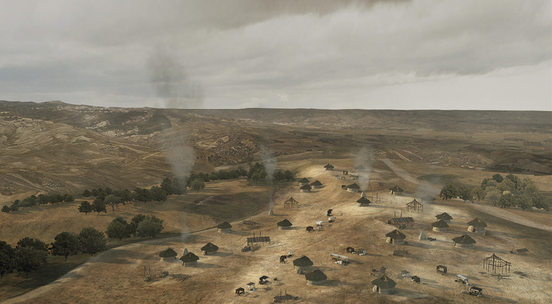
The ancient city of Elea / Velia was said to have been founded by Phocaean Greeks in the sixth century B.C. and then became an ally of Rome in the third century B.C.
An important city of South Etruria located north-northwest of Rome, Veii was eventually sacked by the Romans in 396 B.C. The ancient city covered some 180 ha.
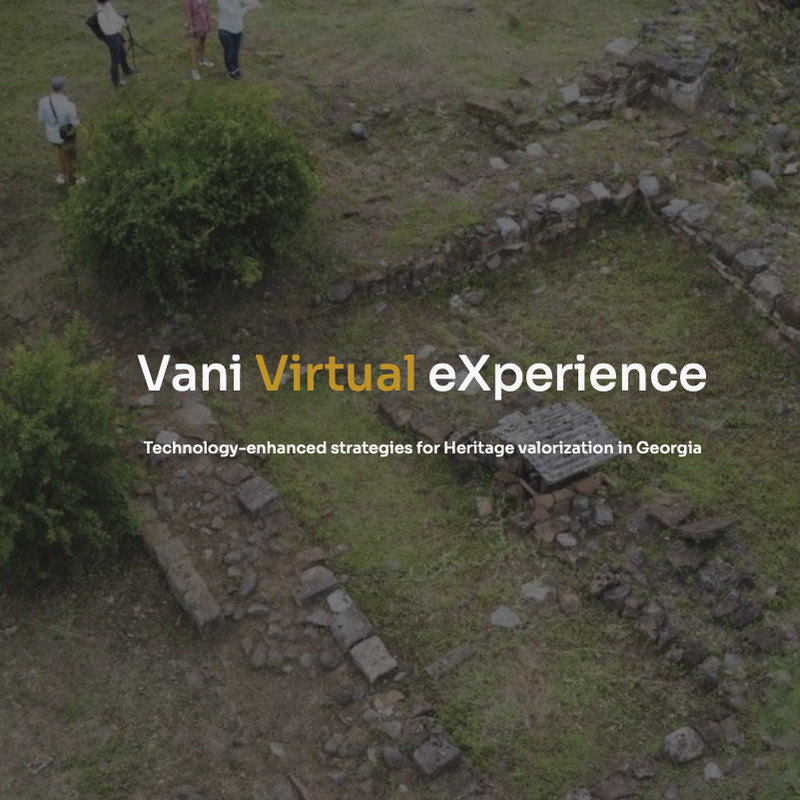
Output of the Bilateral project is the Vani Virtual eXperience, a digital exploration in the historic city of Vani, Imereti region, western Georgia, to admire the wonders of the Past, especially referring to the archaeological area of the so-called mosaic floor temple and its findings - our main case study. Located about 41 km southwest from the regional capital Kutaisi, Vani is an area with continuity of life. The richness of the documentary framework and the variety of the historical and archaeological problems offered today by the ancient city reveal an incredible potential that constitutes a truly significant heritage and a first-level attractive element by making use of new technologies applied to Cultural Heritage. In this light, we had the idea of providing citizens and tourists with a digital interactive tool capable of enhancing and promoting knowledge of the territory, its history and evolution over time. Such a tool has multiple purposes: it can be used as a website, a webapp application, a kiosk desk in the Vani Archaeological Museum and as QRcode panels along the archeological site.
The interactive exploration of Vani Virtual eXperience allows accessing a specific area of the Vani temple-city of historical-archaeological interest: the so-called mosaic floored temple, located a few meters away from the entry gate of Vani and the Archaeological Museum.
V-Ray’s award-winning 3D rendering software helps artists, architects, and designers visualize anything imaginable. Trusted by 92 of the top 100 number architecture firms, V-Ray is built to handle your toughest architectural models and biggest projects.