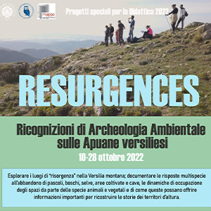
Lo scopo del progetto didattico è quello di introdurre gli studenti allo studio diacronico dei paesaggi abbandonati dell’area apuo-versiliese, esplorando i luoghi di “risorgenza”, ovvero quelle aree che sono state teatro di attività economiche e di sussistenza e che sono oggi abbandonate. Gli studenti saranno invitati ad esplorare le risposte multispecie all’abbandono di pascoli, foreste, aree coltivate e cave, documentando le dinamiche di occupazione degli spazi da parte delle specie pioniere (animali e vegetali) e di come queste possano offrire informazioni importanti per ricostruire le storie dei territori d’altura.
RESEARCH (REmote Sensing techniques for ARCHaeology) aims at testing risk assessment methodology using an integrated system of documentation and research in the fields of archaeology and environmental studies. It will introduce a strategy and select most efficient tools for risk assessment and harmonization of data, criteria, and indicators, to be used to assess and monitor the impact of environmental changes on tangible cultural heritage assets. The project addresses the design and development of a multi-task thematic platform, combining advanced remote sensing technologies with GIS application for mapping and long-term monitoring of archaeological heritage in order to identify changes due to environmental factors, climate change, and anthropic pressures.
Two-dimensional (2D) electrical imaging surveys are now widely used to map areas of moderately complex geology where conventional 1D resistivity sounding and profiling techniques are inadequate. The results from such surveys are usually plotted in the form of a pseudosection (Figure 1a) which gives an approximate but distorted picture of the subsurface geology.
Data and code used for the development of an archaeological inductive predictive model in the southern lake Maggiore (Verbano) area, between Lombardy and Piedmont, Italy. BVER is for "Basso VERbano" (Lower Verbano). The inductive predictive model was originally created as a part of a full scale archaeological research in the area, supported by the Cattedra di Archeologia Cristiana, Tardoantica e Medievale (Chair of Christian, Late Antiquity and Medieval Archaeology) of the University of Milan, department of Cultural and Environmental Heritage. The current work investigates the settlement dynamics of the lower Verbano area between the Iron Age and the Middle Ages. The known archaeological sites, obtained from the public database GNA (Geoportale Nazionale per l'Archeologia), together with a series of physical characteristics of the area, were used as predictors for the calculation of an inductive predictive model. The results show the shortcomings of this methodology in the field of predictive archaeology without an ethnoarchaeological premise. The model is primarily intended to test the reliability of inductive predictive modelling in understanding ancient settlement patterns. The results will then be further discussed and developed. (2025-04-08)
Reflexw is one of the world's most popular geophysical near surface processing and interpretation packages with more than 2000 sold licences. The software covers the complete range of wave data (seismic, GPR, ultrasound) and the different geometry assemblings (surface reflection and refraction, borehole crosshole and tomography and combination of borehole and surface measurements).
Reflectance Transformation Imaging (RTI) is a computation photography technique that captures the surface shape and color of the artefact and enables the interactive re-lighting of the subject from any light direction. Starting from a set of photographs acquired with a fixed camera under varying lighting conditions, RTI encodes the acquired data in a compact way, using view-dependent per-pixel reflectance functions, allowing the generation of new images using any light direction in the hemisphere around the camera place.
RECONSTRUCTOR. THE POWERFUL PROCESSING SOFTWARE FOR LIDAR DATA. A multi-sensor and multi-resolution software used worldwide to manage 3D point clouds and images coming from different lidar and imaging platforms.
- Processing of point clouds and raw data from several laser scanners (terrestrial, handheld, mobile, airborne)
- Integration of point cloud models from UAV and photogrammetric surveys
- Automatic target-less registration of 3D scans from various instruments
- Colourization of point clouds with RGB images from high-res cameras
- Creation of mesh models - Computation of volumes, areas, profiles, contour lines
- Direct export of outputs and formats to the main third-party software (e.g ReCap Pro)