

From Archaeological Survey to Data accessibility: a webgis for the Island of Capri
- Title
- From Archaeological Survey to Data accessibility: a webgis for the Island of Capri
- Creator(s)
- Giovanni CaratelliSee all items with this value
- Cecilia GiorgiSee all items with this value
- Nicolò ParacianiSee all items with this value
- Date
- 2025
- Is Part Of
-
 Archeologia e Calcolatori
- Volume
- 36
- Issue
- 1
- Pages
- 65-86
- Language
- eng
- Abstract
- The project ‘Masgaba. An Archaeological Map for the Island of Capri’ was launched with the aim of updating and integrating Capri’s archaeological documentation, filling the existing gaps in the knowledge of its archaeological heritage using advanced technologies. The methodological approach included new surveys and analyses of sites that required updates in the graphical documentation or had previously been misinterpreted, the analysis of archival sources to recover information on no longer visible archaeological heritage, and the documentation of museum finds that helped improve the understanding of the island’s ancient history. A central element of the project is the creation of a WebGIS, which organizes the data into an interactive digital map, providing an overall view of the island’s archaeological heritage. The web application allows users to consult detailed records, multimedia content, archival documents, and publications produced within the project. The adoption of open-source technologies has ensured the sustainability of the system, paving the way for future extensions and the possibility of integrating new data.
- Tag
- GIS and cartography
- Spatial Coverage
- Capri
- References
-
 SITAR | Sistema Informativo Territoriale Archeologico di Roma
-
 Quantum GIS
-
 PostGIS
-
 PostgreSQL
- WebGIS of the Capri Island
- Zotero References Collection
- https://www.zotero.org/groups/5293298/bidiar/collections/VMIUMHAT
- Cites
- Review of web mapping: Eras, trends and directions
- Open source web software architecture components for Geographic Information Systems in the last 5 years: A systematic mapping study
- SITAR. Sistema Informativo Territoriale Archeologico di Roma, Atti del II Convegno
- Web-based solution for mapping application using open-source software server
- Open source GIS solution: An overview of the architecture of free open source WebGIS
- Edizione archeologica della Carta d’Italia al 100.000. Foglio 196. Vico Equense (Penisola Sorrentina ed Isola di Capri)
- Ricerche topografiche e archeologiche sull’isola di Capri da servire di guida a’ viaggiatori
- Catania archeologia e città: il progetto OPENCiTy Banca Dati, GIS e WebGIS
- Capri. Storia e monumenti
- Villa Jovis. L’edificio residenziale
- Ragguagli di varii scavi, e scoverte di antichità fatte nell’isola di Capri dal sig. Hadrava, e dal medesimo comunicati per lettere ad un suo amico in Vienna
- Verso una nuova carta archeologica per l’isola di Capri. Il contributo del CNR al progetto Masgaba
- La Grotta dell’Arsenale a Capri: analisi del contesto, delle murature e degli apparati decorativi
- La ricerca archeologica a Capri in età borbonica: siti, personaggi, documenti
- Capri antica. Dalla Preistoria alla fine dell’età romana
- L’isola di Capri dal Neolitico alla prima età del Ferro
- Rapporto sullo stato attuale dei ruderi augusto-tiberiani nella isola di Capri. Manoscritto inedito del 1830, pubblicato ed annotato dal nipote Dott. Ignazio Cerio di Capri
- La Penisola Sorrentina e l’Isola di Capri
- Capri. Materials for a Description of the Island
- Il collezionismo di antichità classiche a Capri tra Ottocento e primo Novecento
- In quodam specu concha canentem Tritonem: le grotte-ninfeo di Capri tra architettura, decorazione scultorea e mito
- Capreensia disiecta membra. Augusto a Capri e la villa di Palazzo a Mare
- Le fortificazioni antiche di Capri e la difesa marittima del golfo neapolitano
- Abitare a Capri in età romana: il complesso residenziale di Gradola
- Models as web services using the Open Geospatial Consortium (OGC) Web Processing Service (WPS) standard
- A metrological approach to the study of ancient architecture. The cases of the Grotta dell’Arsenale and the villas of Gradola and Damecuta in Capri
- Le grotte tra Preistoria, età classica e Medioevo. Capri, la Campania, il Mediterraneo. Atti del Convegno Internazionale di Studi (Capri-Anacapri 2021)
- La villa romana di Gradola a Capri. Nuove indagini e prospettive di ricerca
- Storia dell’isola di Capri dall’età remotissima sino ai tempi presenti
- The Grotta di Matermania on Capri. Construction, space and atmosphere of an imperial pavilion
- Per una nuova carta della preistoria caprese. Le ricognizioni di giugno 1999
- Campanien. Geschichte und Topographie des antiken Neapel und seiner Umgebung
- Progetto SITAVR. Una carta archeologica per Verona
- Web GIS and its architecture: A review
- Punto Zero, una nuova web application per la gestione e l’informatizzazione dei dati di archivio. Il caso di Ancona
- Laser scanning e photo scanning. Tecniche di rilevamento per la documentazione 3D di beni architettonici ed archeologici
- Practices of Linked Open Data in Archaeology and Their Realisation in Wikidata
Export
- Media
-
 Archaeological map of the island of Capri with point elements differentiated by type (conserved archaeological assets with identification numbers in red, no longer visible assets in orange, findings in blue, and outcrop areas and pre-protohistoric sites in green)
 -
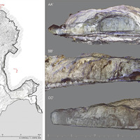 Capri, Grotta dell’Arsenale. Plan and sections from the 3D point cloud model
 -
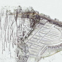 Capri, Villa di Damecuta. Northeast isometric view of the 3D point cloud model (‘clear view’ mode by FARO Scene software)
 -
 Capri, Villa di Damecuta. Photogrammetric elevation of the hemicycle, North view
 -
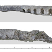
 Capri, so-called Muro greco. Photogrammetric elevation and cross sections
 -
 Web version of the archaeological map. Grotta Azzurra and related sculptures in their original locations
 -
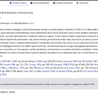 Example of summary data sheet with active bibliography and other tabs with additional information and multimedia content (Villa di Damecuta)
 -
 E.R. diagram of the WebGIS database
 -
 Interactive web version of the archaeological map
 -
 Browsing example for the web map using the interactive menu
Position: 825 (38 views)