

Items
-
Book SectionThe integrated digital approach to the survey and the geometric modeling of the archaeological buildings. The case study of the amphithe atre into Pompeii’s archeological siteThe paper summarises the integrated digital survey activities of the Pompeii Amphitheater conducted through the integration of four digital technologies: 3D laser scanning, GPS and traditional topographic surveyings, high-resolution photographic mapping and digital photogrammetry techniques. The georeferenced point cloud model has been analysed to study the geometric shape of the building and necessary 2D representations are presented, extracted from 3D model.
-
BookThe Imperialisation of Assyria: An Archaeological ApproachThe Assyrian Empire was the first state to achieve durable domination of the Ancient Near East, enduring some seven centuries and, eventually, controlling most of the region. Yet, we know little about how this empire emerged from a relatively minor polity in the Tigris region and how it managed to consolidate its power over conquered territories. Textual sources, often biased, provide a relatively limited source of information. In this study, Bleda S. Düring examines the rich archaeological data of the early Assyrian Empire that have been obtained over the past decades, together with the textual evidence. The archaeological data enable us to reconstruct the remarkably heterogeneous and dynamic impact of the Assyrian Empire on dominated territories. They also facilitate the reconstruction of the various ways in which people participated in this empire, and what might have motivated them to do so. Finally, Düring's study shows how imperial repertoires first developed in the Middle Assyrian period were central to the success of the Neo-Assyrian Empire.
-
Academic ArticleThe impact of the roman agriculture on the territory of SavariaThe first reconstruction of the centuriatio of Savaria was attempted by András Mócsy, who tried to draw itwith the utilization of mid-scale topographical maps. Since his publication there were no archaeological at-tempt in the last 40 years to prove his theory. In the last recent years we tried to continue the survey of theSavarian centuriatio’s existence with support of GIS methods. Fortunately, an interesting relationship wasnoted between the informations of some archaeological excavations and the aerial archaeological phenom-ena, thus, we were able to build a predictive model-network of the assumed centuriatio. The new grid totallydiffers from the previous reconstruction. The predictive model’s agglomeration of the assumed centuriatio-traces could be refined, and the refined model was controlled with the use of archaeological field survey andgeophysical survey as well. The new reconstruction resulted new opportunities in the interpretation of exca-vated sites or former known roman roads and aqueducts, discovered in the last decades. An other interestingrelationship could be found between the water courses that ran on the former territory of the colonia andthe roman field boundary system: the probable impact of the roman agriculture on the landscape that af-fected the “premodern” (prior to the modern stream regulations) watercourse system.
-
Academic ArticleThe Impact of Immersive Technologies on Cultural Heritage: A Bibliometric Study of VR, AR, and MR ApplicationsThis article aims to assist readers in understanding the current status of studies on the subject by providing a descriptive bibliometric analysis of publications on virtual reality (VR), augmented reality (AR), and mixed reality (MR) technologies in cultural heritage. A bibliometric analysis of 1214 publications in this discipline in the Scopus database between 2014 and the beginning of June 2024 was performed. We used VOSviewer and Bibliometrix as the analysis tools in this investigation. The outcome of this study provides a detailed overview of the descriptive bibliometric analysis based on seven categories, including the annual count of articles and citations, the most productive author, the primary affiliation, the publication source, and the subject areas. The contribution of this research lies in offering valuable insights for practitioners and researchers, helping them make informed decisions on the use of immersive technologies, for example, VR, AR, and MR, in the context of cultural heritage.
-
Academic ArticleThe ideal Benedictine Monastery: From the Saint Gall map to ontologiesWe present an OWL 2 ontology, called SaintGall, representing the Saint Gall plan, one of the most ancient documents arrived intact to us. The Saint Gall plan describes the ideal model of a Benedictine monastic complex that inspired the design of many European monasteries. The structural, functional, and architectural specification of an ideal Benedectine monastery is modeled by the SaintGall ontology, which allows one to analyse and model the Monastery architectural type. This work started with the purpose of relating Catania’s San Nicolò l’Arena Benedectine Monastery with the abstract notion of Benedectine monastery, in the ambit of an ontological model based on the renovation works carried out by the architect Giancarlo De Carlo and developed by the same authors. The SaintGall ontology opens a research path aiming at comparing different monastic architectures that can be useful in any intervention of refurbishment or design for a monastery.
-
Academic ArticleThe Iberian town of Ullastret (Catalonia). An Iron Age urban agglomeration reconstructed virtuallyThe Iberian town of Ullastret (6th-2nd centuries BC), in the NE of the Iberian Peninsula, is one of the most important Iron Age archaeological sites in the north-western Mediterranean. It consists of two residential areas, Puig de Sant Andreu and Illa d’enReixac. Separated by only 300 m, together they make up the capital of the Iberian tribe known as the Indiketes, mentioned by classical authors such as Avienus, Ptolemy and Strabo. Decades of continuous archaeological investigation, and especially the geophysics surveys undertaken in recent years, have given us an overall view of the urban structure of this dipolis and its immediate territory, which was occupied and exploited intensively starting mainly in the 4th century BC. This high degree of theoretical knowledge led us to propose the creation of a virtual reconstruction of the whole complex, as well as its contextualisation in its geomorphologic and landscape surroundings. This 3D modelling is an excellent research tool that permits the formulation-validation of hypotheses for architectural reconstruction. It is also especially useful for the creation of applications that add to our knowledge of this heritage site and aid in its presentation and dissemination.
-
BookThe Heritage-Scape: UNESCO, World Heritage, and TourismTourism today is recognized as the largest and fastest-growing industry in the world, capable of producing positive social and economic transformations especially in developing countries. Yet for UNESCO, it works in conjunction with World Heritage sites for a far more ambitious goal: to produce "peace in the minds of men" by creating a new, global identity. Anthropologist and former tour operator Michael Di Giovine draws on ethnographic fieldwork, close policy analysis of UNESCO's major documents, and professional experiences in Southeast Asia and Europe to provide a detailed examination of UNESCO's unusual effort to harness the phenomenon of globalization and the existence of cultural diversity for the purpose of creating "peace in the minds of men" through its World Heritage program. He convincingly argues that UNESCO's designations are not impotent political performances that lead to the commercialization of local monuments for a touristic superstructure, but instead the building blocks of a new world system, an imaginative re-ordering of the world that knows no geopolitical boundaries but exists in the individual "minds of men." Di Giovine terms this system the heritage-scape, a real social structure that extends unbridled across the globe, spreading its mantra of "unity in diversity." Written for social scientists, heritage and tourism professionals, and the educated traveler, The Heritage-scape is an insightful, detailed, and expansive look at the politics and processes, histories and structures, and rituals and symbolisms of the interrelated phenomena of tourism, historic preservation, and UNESCO's World Heritage Program in Viet Nam, Cambodia, and across the world.
-
Academic ArticleThe hbim analysis of the geometry to understand the constructive technique: the use of the use of trompe volume in a brick vaultThe construction of brick-vaulted systems between the 16th and 18th centuries is a typical mark among the noble buildings in large part of Northern Italy. Nowadays they are still a witness of a high level of constructive knowledge by workers, formalized in historical treatises and manuals supporting a literature of theories and practices known since ancient times. The way a vault is geometrically built, regardless of its typology, is not unique and it differs in treatises, according to its location in time and space. The consequence is the generation of “mixed” solutions, where the result of the final volume is achieved by the integration of different generative models and spatial solutions. The observation of cloister vaults, apparently similar to each other but built adopting different constructive techniques within a single building, Magio Grasselli Palace in Cremona, helped to understand this topic.
-
Academic ArticleThe Harris Matrix Data Package specification and the new init command of the Python hmdp toolThis paper presents an update to an earlier proposal for a standardized open format for archaeological stratigraphy data, the Harris Matrix Data Package, and the accompanying software tool implementation. The update is two-fold: firstly, it aims at a clear separation between data format and the software tool, particularly by defining the data format in more detail and independently from the software used to create or analyze it; secondly, it introduces a new software feature that allows the creation of a new ‘data package’ from scratch. A third issue that was identified is the lack of tools for converting existing data to and from the Harris Matrix Data Package, but this issue is not dealt with in this paper.
-
Book SectionThe harbour of the mansio ad speluncas (Brindisi, Italy): A key to sea level changes in the past 3500 years?The archaeological site of Torre Santa Sabina is to the north of Brindisi along the Adriatic coast of Apulia, not far from the ancient Karbinia, the modern Carovigno. It is well known because of the continuous human presence from the Neolithic to the Middle Ages, through Mycenaean and Roman times. It was named ad speluncas during Roman times; when little villages-mansions-were placed along the main roads playing an important role as logistical stations between the main cities. Numerous archaeological structures have been found in the coastal area of the mansio ad speluncas. They are land indicators or sea indicators since they only indicate that sea level was lower or higher than present at the time of their building. The most important sea level indicators are two wrecks of Roman ships ascribed to the Late Republic or Ist century of the Imperial Age. Beached at the mean depth of 2.5m b.p.s.l. sea level, they could indicate the position of the sea level at the time of their abandonment on the beach. The archaeological remains suggest that about 3300 years ago the sea level stood up to 3m below the present one; 2200 years it raised up to 2.5m lower than the present one as also indicated by data coming from the near harbour of Egnatia. The following rise of the sea level has been responsible for the flooding of medieval structures.
-
Academic Article
-
BookThe Great Hypostyle Hall in the Temple of Amun at KarnakFree PDF from the Oriental Institute: great-hypostyle-hall-temple-amun-karnak Standing at the heart of Karnak Temple, the Great Hypostyle Hall is a forest of 134 giant sandstone columns
-
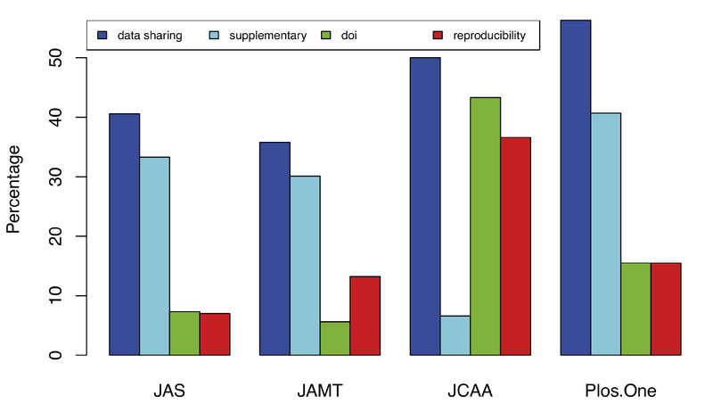 Academic ArticleThe good, the bad and the ugly: evaluating Open Science practices in archaeologyIn the past decade, archaeology has witnessed a surge in digital data and methodologies made accessible through online repositories, databases, collaborative platforms like GitHub, and library collections. While this ‘digital revolution’ has lead to notable advancements in data accessibility and dissemination, it has also presented several challenges. These include developing effective data management strategies, defining scientific publication modalities, addressing ethical concerns regarding the protection of cultural heritage, and bridging the gap between rich and poor research institutions. Taking these challenges into account, this paper aims to outline best practices for data sharing, dissemination, and reproducibility in archaeology, underscoring their benefits to researchers and the wider public. Through a range of approaches and practical examples drawn from everyday research scenarios, we will demonstrate how these practices promote transparency and foster open science.
 -
Academic ArticleThe golden years for mathematics and computers in archaeology (1965-1985)A major quantitative movement in all of the Social and Human Sciences known as Operational Research, started after the last world war with the application of mathematics developed for the optimization of war logistics. Since the 1960s, the fascinating progress of computer technology in the field of scientific research has amplified the movement which saw the first applications to Archaeology around 1966. At the time, the success of a Quantitative Archaeology was associated with the revolution in multidimensional data analysis, which occurred with computerisation and improvements in the algorithms, mainly Multidimensional scaling, Factor Analysis, Principal Component Analysis, Correspondence Analysis and various Cluster Analyses. The Conference of Mamaia (Romania) in 1970, which may be considered as the first and most spectacular scientific event of this period of foundation, found expression in the book Mathematics and Computers in Archaeology by Doran and Hodson (1975). From 1975 to 1985, the quantitative movement experienced its finest period with the transition from the research field to the application field, both for algorithms and software, and the diffusion of Correspondence Analysis, Principal Component Analysis associated with Cluster Analysis and their use by archaeologists. Numerous papers and books were published during that period. After 1985, the quantitative movement fell into disfavour, probably due to the "deconstruction" paradigm and the passing fashion of expert systems. Nevertheless, it is also possible to state that Quantitative Archaeology had now definitively entered into the standard methods of Archaeology.
-
conference paperThe Glozz platform: a corpus annotation and mining toolCorpus linguistics and Natural Language Processing make it necessary to produce and share reference annotations to which linguistic and computational models can be compared. Creating such resources requires a formal framework supporting description of heterogeneous linguistic objects and structures, appropriate representation formats, and adequate manual annotation tools, making it possible to locate, identify and describe linguistic phenomena in textual documents. The Glozz platform addresses all these needs, and provides a highly versatile corpus annotation tool with advanced visualization, querying and evaluation possibilities.
-
Academic ArticleThe Global Burden of Journal Peer Review in the Biomedical Literature: Strong Imbalance in the Collective EnterpriseThe growth in scientific production may threaten the capacity for the scientific community to handle the ever-increasing demand for peer review of scientific publications. There is little evidence regarding the sustainability of the peer-review system and how the scientific community copes with the burden it poses. We used mathematical modeling to estimate the overall quantitative annual demand for peer review and the supply in biomedical research. The modeling was informed by empirical data from various sources in the biomedical domain, including all articles indexed at MEDLINE. We found that for 2015, across a range of scenarios, the supply exceeded by 15% to 249% the demand for reviewers and reviews. However, 20% of the researchers performed 69% to 94% of the reviews. Among researchers actually contributing to peer review, 70% dedicated 1% or less of their research work-time to peer review while 5% dedicated 13% or more of it. An estimated 63.4 million hours were devoted to peer review in 2015, among which 18.9 million hours were provided by the top 5% contributing reviewers. Our results support that the system is sustainable in terms of volume but emphasizes a considerable imbalance in the distribution of the peer-review effort across the scientific community. Finally, various individual interactions between authors, editors and reviewers may reduce to some extent the number of reviewers who are available to editors at any point.
-
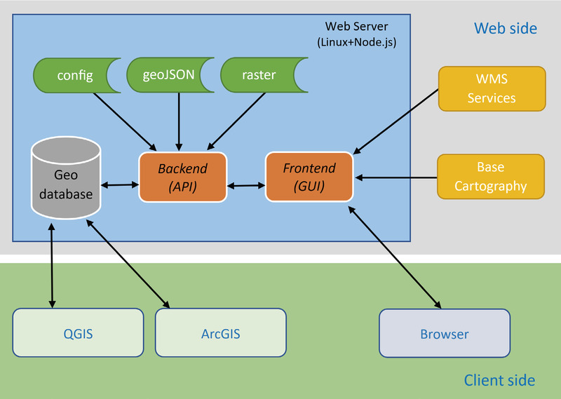 Academic ArticleThe GISTArc webGIS for the accessibility and sharing of archaeological data in CampaniaThe GISTArc project envisions the implementation of a webGIS environment for the management and visualization of geoarchaeological data from research included in the Archaeological Map of Northern Campania project, conceived and directed by Stefania Quilici Gigli. The creation of the new system began with the normalization of some completed research data. They were managed in a GIS environment and were subsequently imported into a Web geodatabase, with the preparation of layers containing all the textual, graphical/ photographical and spatial information of the catalogued archaeological evidence, together with the required bibliographical references. The GISTArc project has a threefold aim: make the results of archaeological research conducted in some sectors of northern Campania more usable; allow the researcher to consult, integrate and enter the data from future research, thanks to the connection to the system via the Internet and the possibility of recording data directly during the survey; and finally access via standard desktop applications, such as Quantum GIS and ArcGIS, rather than the internet-based GISTArc geodatabase, in order to use advanced data analysis and representation functions that may not be available online. This paper describes the technical and scientific approach to the creation of our webGIS. It focuses on the system architecture, operative environment, and development tools.
 -
BookThe Geography of Trade: Landscapes of Competition and Long-distance Contacts in Mesopotamia and Anatolia in the Old Assyrian Colony PeriodFrom the mid-20th century onwards, consolidated study of the merchant archives from the Old Assyrian trading colony at Kaneš (Kültepe) has not only transformed our understanding of the social, economic and political dynamics of the Bronze Age Near East, but also overturned many preconceived notions of what constitutes pre-modern trade. Despite this disciplinary impact and archaeological investigations at Kültepe and elsewhere, our understanding of this phenomenon has remained largely text-based and therefore of limited analytical scope, both spatially and contextually. This book re-assesses the Old-Assyrian trade network in Upper Mesopotamia and Central Anatolia during the Middle Bronze Age (c. 1970 – 1700 BC) by combining in some analytical detail the archaeology (e.g. material culture, settlement data, etc.) of the region both on its own terms and via a range of spatial approaches. The author offers a comparative and spatial perspective on exchange networks and economic strategies, continuity and discontinuity of specific trade circuits and routes, and the evolution of political landscapes throughout the Near East in the Middle Bronze Age.
-
Academic Article
-
Academic Article
-
Academic Article
-
Academic ArticleThe future (?) of effective protectionThis paper aims at a comparative reading of some archaeological remains in the island of Sardinia, starting from a reflection on the UNESCO discipline, which introduces a hierarchy of cultural heritage based on the level of worthiness of protection and provides enhanced protection for the goods that are on its list. The main goal of the study is to investigate in parallel the application of this ‘selective appreciation’ on the actual context of the protection of the so-called ‘real cultural heritage’ (article 9 of the Italian Constitution). The study proceeds by comparing some important sites on the island having similar contextualization, but different strategies for protection: the Archaeological Park of Porto Torres, Su Nuraxi in Barumini, registered since 1997 in the World Heritage List of UNESCO, and the archaeological area of Neapolis (Oristano). From comparisons and analysis carried out in selected areas it was possible to focus attention on some critical aspects of the UNESCO rules and on contradictions between the operational guidelines and the objectives that the organization provides for the protection of property. In the wake of new reforms for the reorganization of the Ministry of Heritage, Culture and Tourism, the critical issues discussed in this paper appear even more evident in Sardinia. The idea of a ‘protection of the exceptional’ appears to reduce the opportunities of intervention, by isolating the evidence from its context and making the action of protection inadequate for the territory and for the same items contained therein.
-
Academic ArticleThe funerary landscape of late antique and early medieval Lucca through Point Pattern AnalysisLocated in northern Tuscany, the city of Lucca represents a perfect case study to understand the development of the late antique funerary landscape. Although numerous burials are known for the 5th-7th century timespan, few studies have explored the factors that led to the formation of several cemetery areas within urban and suburban spaces. This study thus aims to investigate spatial interactions among burials and assess the role of urban and suburban elements in creating funerary landscapes through Point Pattern Analysis.
-
BookThe Fourth Paradigm: Data-intensive Scientific DiscoveryThis book presents the first broad look at the rapidly emerging field of data-intensive science, with the goal of influencing the worldwide scientific and computing research communities and inspiring the next generation of scientists. Increasingly, scientific breakthroughs will be powered by advanced computing capabilities that help researchers manipulate and explore massive datasets. The speed at which any given scientific discipline advances will depend on how well its researchers collaborate with one another, and with technologists, in areas of eScience such as databases, workflow management, visualization, and cloud-computing technologies. This collection of essays expands on the vision of pioneering computer scientist Jim Gray for a new, fourth paradigm of discovery based on data-intensive science and offers insights into how it can be fully realized.
-
Academic ArticleThe flower woman figurines from the Foce Sele Hera Sanctuary. Ancient coroplastic digital data management, analysis, and sharingThe paper focuses on the digital strategies developed in the study of the corpus of flower woman terracotta figurines found in the excavations carried out by Paola Zancani Montuoro and Umberto Zanotti Bianco at the Foce Sele Hera Sanctuary and stored in the National Archaeological Museum of Paestum. The flower woman definition identifies the best known structure of the statuettes composed of a female bust supporting a flower orthogonal to the base. Actually, the scientific literature about these peculiar artifacts reveals a diffused vagueness and ambiguity in the definition, formalization, and functional exegesis, encouraging a new comprehensive study. The main results come from: digital management of the information; seriation analysis supported by a quantitative approach; visualization of occurrences in the Mediterranean Basin based on Fusion Tables; testing of multidisciplinary approaches to cooperative content building in archaeology. The study developed a whole technology-enhanced workflow, including multimedia data digital management and sharing; statistical techniques for the analysis of terracotta shrinkage in moulded coroplastic figurines seriation; webGIS visualization of occurrences in the ancient Mediterranean Basin and their relations.
-
Book SectionThe Fate of Bells Under Ottoman Rule: Between destruction and negotiation 1Alex Rodriguez Suarez explores the significance of bell ringing as a vital element within the Christian soundscape – both Orthodox and Catholic. This is partly
-
Book Section
-
Academic ArticleThe falerii novi projectThe Falerii Novi Project represents a newly formed archaeological initiative to explore the Roman city of Falerii Novi. The project forms a collaboration of the British School at Rome with a multinational team of partner institutions. Thanks to a rich legacy of geophysical work on both the site and its territory, Falerii Novi presents an exceptional opportunity to advance understanding of urbanism in ancient and medieval Italy. The Falerii Novi Project employs a range of methodologies, integrating continued site-scale survey with new campaigns of stratigraphic excavation, archival research and environmental archaeology. The project aims to present a more expansive and holistic urban history of this key Tiber Valley settlement by focusing on long-run socio-economic processes both within Falerii Novi and as they linked the city to its wider landscape., Il Falerii Novi Project rappresenta un'iniziativa archeologica di recente formazione per indagare la città romana di Falerii Novi. Il progetto nasce dalla collaborazione della British School at Rome con un team internazionale di istituzioni partner. Grazie a una ricca ‘eredità’ di lavori geofisici sia sul sito che sul suo territorio, Falerii Novi rappresenta un'opportunità eccezionale per favorire l'avanzamento della comprensione del fenomeno urbano nell'Italia antica e medievale. Il Falerii Novi Project impiega un'ampia gamma di metodologie, integrando la prosecuzione dei rilievi ad una scala di sito con nuove campagne di scavo stratigrafico, ricerca d'archivio e archeologia ambientale. Il progetto mira a presentare una storia urbana più ampia e olistica di questo insediamento chiave della Valle del Tevere, concentrandosi sui processi socioeconomici di lungo periodo sia all'interno di Falerii Novi sia tra la città e il suo più ampio ambito territoriale.
-
Academic ArticleThe FAIR Guiding Principles for scientific data management and stewardshipThere is an urgent need to improve the infrastructure supporting the reuse of scholarly data. A diverse set of stakeholders—representing academia, industry, funding agencies, and scholarly publishers—have come together to design and jointly endorse a concise and measureable set of principles that we refer to as the FAIR Data Principles. The intent is that these may act as a guideline for those wishing to enhance the reusability of their data holdings. Distinct from peer initiatives that focus on the human scholar, the FAIR Principles put specific emphasis on enhancing the ability of machines to automatically find and use the data, in addition to supporting its reuse by individuals. This Comment is the first formal publication of the FAIR Principles, and includes the rationale behind them, and some exemplar implementations in the community.
-
Academic Article
-
Academic Article
-
Academic ArticleThe evolution of architectural features at the protohistoric settlement of Acinipo (Ronda, Andalusia). From rounded houses to rectilinear structures and rounded againArchitectural design constitutes an important source of information for the study of prehistoric societies. In the protohistoric period, an architectural evolution took place in western Andalusia (Spain): the change from rounded to rectangular huts, and a new evolution to more complex houses formed by rectilinear thick walls and others less thick to shape small rooms. This paper analyses the metric and geometric features of the Acinipo protohistoric settlement (Ronda, Málaga, Andalusia) to determine the main architectural pattern in each construction phase. These analyses emphasize the evolution in the design from rounded huts to rectangular ones, but this type of construction returns to its origins with the more recent circular and elliptical huts. The comparison between these features reflects the similarities and differences arising over time in the settlement. Geometrically, regular shapes such as circles, ellipses and rectangles, as well as the orthogonality and parallelism concepts, were applied to the design and building of dwellings. Therefore, the individual huts were aligned to form a regular structure of the town, maintaining the surface area through time. The results provide evidence that geometry constitutes one of the most important multicultural symbols in the world of the architecture and its evolution shows the evolution of society.
-
Academic ArticleThe Euesperides project: design and evaluation of a hypermedia program for an archaeological exhibitionThis paper focuses on the Euesperides program, a hypermedia application for the public presentation and interpretation of archaeology and the main issues related to its design and evaluation. The project was set up in Oxford in order to explore some of the questions concerning the effectiveness of multimedia for exhibition interpretation. The computer program presents the history and archaeology of the classical Greek colony Euesperides in North Libya. The application was designed for a temporary exhibition organized by the Ashmolean Museum, Oxford in autumn 1995. It aimed to offer contextual and interpretive information about the objects on display, and also to demonstrate aspects of archaeological theory and practice. The paper discusses the structure of the program and the ways user input affected design choices. At several stages through the design process, formative evaluation was carried out with different groups of the targeted audience (schoolchildren, adults, students). This offered valuable feedback about the content, language, screen design, navigation, and user interface of the program. Summative evaluation was also conducted to explore the use of the hypermedia program by the visitors in the gallery. The paper refers to the methodology used, outlines the questions that the survey addressed, and presents the first results.
-
Academic ArticleThe ethnographer and the algorithm: beyond the black boxA common theme in social science studies of algorithms is that they are profoundly opaque and function as “black boxes.” Scholars have developed several methodological approaches in order to address algorithmic opacity. Here I argue that we can explicitly enroll algorithms in ethnographic research, which can shed light on unexpected aspects of algorithmic systems—including their opacity. I delineate three meso-level strategies for algorithmic ethnography. The first, algorithmic refraction, examines the reconfigurations that take place when computational software, people, and institutions interact. The second strategy, algorithmic comparison, relies on a similarity-and-difference approach to identify the instruments’ unique features. The third strategy, algorithmic triangulation, enrolls algorithms to help gather rich qualitative data. I conclude by discussing the implications of this toolkit for the study of algorithms and future of ethnographic fieldwork.
-
Academic ArticleThe Erbil Plain Archaeological Survey: Preliminary Results, 2012-2020The Erbil Plain Archaeological Survey (EPAS) investigates settlement and land use from the Neolithic to the present in the Erbil Governorate of the Kurdistan Region of Iraq, which includes a large portion of the core of the Assyrian Empire. In seven field seasons, it has documented a broad settlement landscape in a region of great social and political importance, especially in the Bronze and Iron Ages, including 728 archaeological sites. Its field methodology combines traditional surface collection with the use of historical aerial and satellite photographs, mobile GIS, and UAV (drone) photogrammetry. Preliminary results show some unexpected patterns: a high density of culturally Uruk settlements in the fourth millennium B.C., variable urban morphologies in the Early Bronze Age; and large but low-density settlements at the end of the Sasanian period or the early Islamic period. The project is explicitly testing several hypotheses about centralized Neo-Assyrian landscape planning in the imperial core. These hypotheses appear to be confirmed, although the situation was more complex than in surrounding provinces, probably due to the longer history of continuous settlement. Click here to download the PDF of this article.
-
Academic ArticleThe epigraphic project of the Laboratory of Epigraphy (EpiLab), Department of Humanities (Trieste University).Paper presented at the Italic inscriptions and databases workshop.
-
Academic ArticleThe entasis of greek doric columns and curve fitting. A case study on the peristyle column of the temple of the Athena Alea at TegeaIn this paper it is suggested that least squares approximation can be used to analyse and to produce computer images of the entasis of Greek Doric columns. The curve fitting method is then applied in a case study on the peristyle column of the temple of Athena Alea at Tegea. By analysing the shaft profile of the different drum combinations it is possible to give the most likely range for the column height.
-
Book
-
Academic Article
-
Academic ArticleThe Emergence of Concentrated Settlements in Medieval Western Europe: Explanatory Frameworks in the HistoriographyThere is now a general scholarly consensus that the concentration of rural people into settlements in Western Europe (as opposed to dispersed or scattered habitations across the countryside) occurred in various stages between the eighth and twelfth centuries, though with regional divergences in precise timing, speed, formation, and intensity. What is clear from the literature is that a “one-size fits all” model for settlement development across Western Europe is not possible. Concentrated settlements appeared in certain parts of Europe for different reasons. This article discusses the strengths and limitations of four of the most influential frameworks for explaining patterns of medieval settlement concentration and their relation to social and economic change. The frameworks under analysis emphasize, respectively, power, coercion and lordship; communalism and territorial formalization; field systems and resource management; and urbanization and market-integration.
-
Academic ArticleThe ecological niche and distribution of Neanderthals during the Last InterglacialAim In this paper, we investigate the role of climate and topography in shaping the distribution of Neanderthals (Homo neanderthalensis) at different spatial scales. To this end, we compiled the most comprehensive data set on the distribution of this species during the Last Interglacial optimum (MIS 5e) available to date. This was used to calibrate a palaeo-species distribution model, and analyse variable importance at continental and local scales. Location Europe and Irano-Turanian region (20° N to 70° N, 10° W to 70° E). Methods We used archaeological records and palaeoclimatic and topographic predictors to calibrate a model based on an ensemble of generalized linear models fitted with different combinations of predictors and weighted background data. Area under the curve scores computed by leave-one-out were used to assess variable importance at the continental scale, while local regression combined with recursive partition trees was used to assess variable importance at the local scale. Results Annual rainfall and winter temperatures were the most important predictors at the continental scale, while topography and summer rainfall defined habitat suitability at the local scale. The highest habitat suitability scores were observed along the Mediterranean coastlines. Mountain ranges and continental plains showed low habitat suitability values. Main conclusions The model results confirmed that abiotic drivers played an important role in shaping Neanderthals distribution during the Last Interglacial. The high suitability of the Mediterranean coastlines and the low suitability values of most sites at the northern and eastern distribution limits (Germany, Hungary, Ukraine) challenge the notion of Neanderthals as a species with preference for colder environments.
-
Academic ArticleThe East Mediterranean Pottery Project. Exchange of specialized data on the information superhighwayThe information superhighway, technology has made it possible to create world wide multiple server databases for scientific and humanistic research. These allow a deeper level of exchange of data in archaeology than news services and information about excavation projects. The archaeological information passed along Internet channels is bringing scholars to think together in a way never before seen in the history of the research. The Israel Antiquities authority East Mediterranean Pottery Project is an attempt to enable searches on multiple database servers containing information about ceramic objects in museum and private collections. The search engine is based on HTML forms that provides a platform and operating system independent environment required by a widely distributed database search. The two main obstacles in the expanding of the system are terminological problems arising from language and usage differences and the Jack of a common system for type identification. The suggested solutions include the creating or adopting on local level of a pottery Thesaurus that allows extensive conceptual aliasing between distributed databases and the adopting of the DELTA syntax for passing typological identification keys between different databases. The future will show how the launching of the EMP project will be received by the international community and what is the growth potential of this and other similar scientific projects appearing on the information superhighway.
-
BookThe Early Roman Expansion into ItalyThis book presents a radical new interpretation of Roman expansion in Italy during the fourth and third centuries BCE. Nicola Terrenato argues that the process was accomplished by means of a grand bargain that was negotiated between the landed elites of central and southern Italy, while military conquest played a much smaller role than is usually envisaged. Deploying archaeological, epigraphic, and historical evidence, he paints a picture of the family interactions that tied together both Roman and non-Roman aristocrats and that resulted in their pooling power and resources for the creation of a new political entity. The book is written in accessible language, without technical terms or quotations in Latin, and is heavily illustrated.
-
conference paperThe Early Bronze Age in North Eastern Italy: the Making of a Monumental LandscapeThe most recent field researches in Friuli have demonstrated that at the beginning of the Early Bronze Age the landscape of the Upper Plain was largely shaped by kin groups settled in short-lasting hamlets. In order to assert their possession of the surrounding land, and to celebrate their ancestors, these small communities built a large number of round barrows of pebbles and earth, some of which have survived until the present day. About 1900 B.C. this landscape, dotted with tumuli, began to be developed with more substantial, longer-lasting settlements provided with defences of clayey earth. In the most ancient of these villages discovered so far, some burials were found inside the core of the rampart. This feature, as well as other – structural or ritual – details, indicates both the transition to a new way of living and the strong connection with the tradition of burial tumuli.
-
Academic ArticleThe earliest balance weights in the West: Towards an independent metrology for Bronze age EuropeWeighing devices are the earliest material correlates of the rational quantification of economic value, and they yield great potential in the study of trade in pre-literate societies. However, the knowledge of European Bronze Age metrology is still underdeveloped in comparison to Eastern Mediterranean regions, mostly due to the lack of a proper scientific debate. This paper introduces a theoretical and methodological framework for the study of standard weight-systems in pre-literate societies, and tests it on a large sample of potential balance weights distributed between Southern Italy and Central Europe during the Bronze Age (second–early first millennium bc). A set of experimental expectations is defined on the basis of comparisons with ancient texts, archaeological cases and modern behaviour. Concurrent typological, use-wear, statistical and contextual analyses allow to cross-check the evidence against the expectations, and to validate the balance-weight hypothesis for the sample under analysis. The paper urges a reappraisal of an independent weight metrology for Bronze Age Europe, based on adequate methodologies and a critical perspective.
-
Academic ArticleThe EAGLE networkPaper presented at the Italic inscriptions and databases workshop.
-
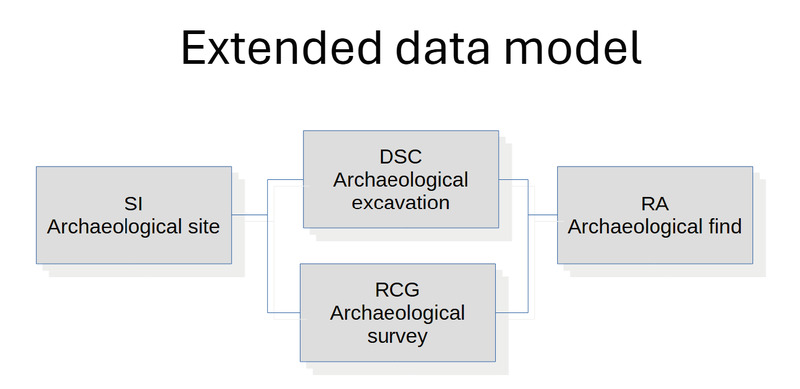 Academic ArticleThe DSC authority file: a link between fieldwork and findsStarting in 2017, the Soprintendenza Archeologia, Belle Arti e Paesaggio per la città metropolitana di Genova e le province di Imperia, La Spezia e Savona (SABAP-LIG) began activities to inventory archaeological assets through the ‘in batches’ inventory system based on the new MINP standard module. The activity was carried out with funds allocated by the General Directorate and has continued annually until 2023, leading to the compilation of about 13,000 modules. Since the first experiment, the DSC (Archaeological Excavation) authority file, which has been developed among the ICCD authority file standards for a while, but used sparingly. It has been identified as a crucial element of the activity because it can be used as a link between catalogue of records describing finds (MINP, MINV) and records describing archaeological sites. Despite the relative simplicity of the data model compared to state-of-the-art initiatives in archaeology data modelling, still it allows an improvement in finds management and knowledge about archaeological heritage.
 -
Academic ArticleThe drawing of Hadrian’s Villa in Tivoli. Extensive survey for heritage documentationThe documentation project for the digital representation of Hadrian’s Villa represents a multi-year survey program promoted by Joint Laboratory University and Enterprise “Landscape Survey & Design” with the aim of providing to the Superintendence a three-dimensional database of Villa’s rooms, capable to describe the state of places. Hadrian’s Villa represents the highest expression of imperial architecture, combining spaces linked both to political needs and to recreational and leisure activities in a complex with urban articulation immersed in the harmony of a landscape where nature permeates the structures with pools, water games and visual cones that open up to Rome. The documentation and survey activities of the ruins, have produced today a partial database of the Villa made up of high density point clouds from which 3D models are processed to study morphological systems, construction details and walls.
-
Academic ArticleThe Domus of the Calendar: a qualitative comparison analysis of digital data obtained from 3D laser scanners, SfM methodologies and portable devicesData acquisition digital methodologies have become a reliable tool for surveying buildings with heritage values. Laser scanning has become the preferred method for performing 3D digital surveys because of its high accurate results; even though, the cost associated with it is usually high. Emerging technologies have been able to produce low-cost data acquisition methods, and they are currently being incorporated as part of digital survey projects. Using the ‘Domus of the Calendar’ as a case study – an exceptionally unique archaeological and architectural site that was incorporated to the structural foundation system of the basilica of Santa Maria Maggiore – the present investigation aims to evaluate the data quality of two low-cost emerging technologies, namely SfM (Structure from Motion) and the iPad LiDAR system. This evaluation was developed by comparing low-cost technologies data acquisition capabilities with those of the laser scanner. The data for this test was obtained during an integrated survey campaign aimed at executing a critical analysis of the many historical layers of the Santa Maria Maggiore basilica. The results obtained from this investigation highlights the reliability of the different techniques implemented and suggest a useful solution for different and recurrent multi-scalar contexts.
-
Academic ArticleThe documentation and reintegration of a lost pastThe paper describes how new digital methodologies can be used within the field of Cultural Heritage, not only with the aim of documenting the actual state of an architecture but to review the past transformations it has undergone, conserving and representing these histories as well. Over the last few years, the methodologies of acquisition and integrated representation for 3D patrimony documentation have developed and consolidated considerably: the possibilities of the digital realm can augment the understanding and the valorisation of a monument. The specific case offered in the present paper, the Scuola Vecchia della Misericordia in Venice, is a significant example. It suggests not only the theme of the "no longer existing" regarding its façade, which has undergone evident modifications, but also the recontextualization of a number of decorative elements, such as the bas-reliefs which once marked the entrance and are today conserved in the Victoria and Albert Museum, London. The described experience shows how integrated methodology, from high resolution laser scanning and photogrammetric survey to 3d modelling, can develop a reliably virtual diachronical reconstruction from different sources of an historical building. Geomatic tools combined with computer graphics provide a better understanding of building history through the use historical documents, playing a paramount role in preserving and valorizing the cultural and environmental heritage.
-
Academic ArticleThe Digital Revolution to Come: Photogrammetry in Archaeological PracticeThe three-dimensional (3D) revolution promised to transform archaeological practice. Of the technologies that contribute to the proliferation of 3D data, photogrammetry facilitates the rapid and inexpensive digitization of complex subjects in both field and lab settings. It finds additional use as a tool for public outreach, where it engages audiences ranging from source communities to artifact collectors. But what has photogrammetry's function been in advancing archaeological analysis? Drawing on our previous work, we review recent applications to understand the role of photogrammetry for contemporary archaeologists. Although photogrammetry is widely used as a visual aid, its analytical potential remains underdeveloped. Considering various scales of inquiry—graduating from objects to landscapes—we address how the technology fits within and expands existing documentation and data visualization routines, while evaluating the opportunity it presents for addressing archaeological questions and problems in innovative ways. We advance an agenda advocating that archaeologists move from proof-of-concept papers toward greater integration of photogrammetry with research., La revolución tridimensional (3D) prometió transformar la práctica arqueológica. De las tecnologías que han contribuido a la proliferación de datos en 3D, la fotogrametría facilita la digitalización rápida y económica de sujetos complejos tanto en el laboratorio como en el campo. Además, hay utilidad en aplicar la fotogrametría como una técnica de alcance comunitario, donde involucra a audiencias diversas desde comunidades de origen hasta coleccionistas de artefactos. Pero ¿para qué ha servido la fotogrametría en avanzar el análisis arqueológico? Aprovechando estudios anteriores publicados por los autores, revisamos aplicaciones recientes para entender el papel de la fotogrametría para arqueólogos contemporáneos. Aunque ampliamente empleado como ayuda visual, su potencial analítico permanece poco desarollado. Considerando varias escalas de investigación—pasando desde objetos hasta paisajes—examinamos cómo la tecnología encaja dentro y expande métodos existentes de documentación y visualización de datos, mientras evaluamos la oportunidad que presenta en abordar preguntas y problemas arqueológicos en formas innovadoras. Avanzamos una agenda que apoya a que arqueólogos avancen de trabajos de prueba de concepto a una mayor integración con la investigación.
-
Academic ArticleThe digital Gazetteer of Ancient Arabia: An example of reuse and exploitation of annotated textual corporaAnnotated corpora, provided that they adopt international standards and expose data in open format, have many more chances to be easily exploited and reused for different objectives than traditional, analogue corpora. This paper aims at presenting the results of the early adhesion to best practices and principles afterward codified as Open Science and FAIR principles in the frame of projects concerned with digital textual corpora, in a niche area of research such as the pre-Islamic Arabian epigraphy. The case study analysed in this paper is the Digital Archive for the Study of pre-Islamic Arabian inscriptions – DASI, an online annotated corpus of the textual sources from Ancient Arabia, which also exposes its records in standard formats (oai_dc, EpiDoc, EDM) in an OAI-PMH repository. The initiatives of reuse of DASI open data in the frame of the recently ANR-funded project Maparabia (CNRS-CNR) are discussed in the paper, focusing on the exploitation of DASI’s onomastic and geographic data in a new reference tool, the Gazetteer of Ancient Arabia. After introducing DASI and Maparabia projects and highlighting the objectives of the Gazetteer, the paper describes the conceptual model of its database and the module importing data from DASI. The population of the Gazetteer, implying also a data entry and manipulation phase, is exemplified by the case-study of the Ancient South Arabian place ‘Barāqish/Yathill’. Based on the above experience, limitations and opportunities of data reuse and synchronisation issues between systems are discussed.</p>
-
conference paperThe Digital 3D Survey as Standard Documentation of the Archaeological StratigraphyIn this contribution we describe tools and methods used to perform three-dimensional photogrammetric survey of different archaeological contexts. In particular, we studied in depth some aspects: swiftness (of the proceeding), accuracy (of the measurement), informative contents (of the registration) and cost (of the instruments). Considering these factors we propose some solutions for the integration of photomodelling and stereophotogrammetry within the current standards of archaeological documentation. The first part will show three-dimensional photomodelling examples of walls stratigraphy and structural elements. Then follows the comparative analysis of two different technique of survey for the documentation of the same archaeological context: the direct detection and the stereophotogrammetric one of a burial. The second part discusses the first results of an experiment still in progress: the documentation of all the contexts identified during an archaeological excavation by stereo-detection. The contribution closes with an experience of photogrammetric survey of petroglyphs.
-
Academic ArticleThe development and architectural significance of early Etrusco-Italic podiaThe incorporation of podia into Etruscan and Latial religious buildings during the 6th century BC marks the emergence of temples as a distinct architectural form in both the urban landscape and the archaeological record. Consideration of the significance of this change in elevation, however, has largely been overlooked to date in preference for the presentation of podia as a Roman form derived from Etruscan sacred aesthetics. This review of the evidence for the chronological and geographical development of podia in central Italy will suggest a means of differentiating podia from other substructures, demonstrate that they can be recognised in Latium before Etruria, and argue that their introduction may represent an architectural response to particular local conditions.
-
Academic ArticleThe Development And Application Of A Simple Methodology For Recording Rock Art Using Consumer-Grade Digital CamerasA simple methodology for recording rock art has been recently developed in Australia and tested on Aboriginal rock art, including both petroglyphs and pictographs (engraved and painted images, respectively). The approach was based on commercial photogrammetric software and consumer-grade digital cameras, because it was believed that archaeologists, conservators and site managers need simple and cost-effective methods to record and document rock art. This methodology has been adopted subsequently by the Northumberland and Durham Rock Art Project working in conjunction with English Heritage, to assist in recording 1500 prehistoric engraved panels located across the north-east of England. Significantly, the fieldwork was carried out by enthusiastic volunteers, willing to sacrifice their weekends to capture imagery suitable for digital photogrammetry. This paper explains briefly how the recording technique was developed in Australia before indicating how expertise and equipment were integrated to allow UK-based volunteers to carry out data acquisition and, perhaps surprisingly, also the photogrammetry. This will demonstrate the value of mobilising the voluntary sector for heritage recording, which is feasible only if recording methodologies are based on cheap and simple instrumentation.
-
Academic ArticleThe Democratization of Processes and the Use of Remotely Guided Acquisition Tools for Survey 2.0The technology that ‘amplifies’ the real world as well as the technological means of data capturing, are continuing to have a development difficult to control or predict. Projects of a certain interest are born, develop and die sometimes without producing significant results nevertheless becoming phases of a fluid and dynamic process, on which new software applications and hardware systema are built. At the same time, the role of the academy seems to be often overtaken by what is developed by the citizen science. Researchers no longer seem to exclusively explore the ‘discovery’ domain, but rather work at the setup of scientifically reliable protocols for technologies often used by different communities of citizens in a way that does not conform to the specifications for which they were originally designed. This paper focuses on these issues taking as its starting point two experiments with high innovative content that cover various stages of the process defined by the term Survey. They pertain on the one hand to a hw/sw system of data capturing, processing and communication developed for mobile devices (Tango Project) and on the other to a mixed ROV/UAV multisensor platform equipped with a LIDAR system and digital camera for data acquisition in inaccessible places (Heritagebot Project).
-
Academic ArticleThe Davanzali necropolis of Numana (AN): from the archaeological context to the virtual environmentThe paper focuses on the issues of archaeological interpretation of the Quagliotti-Davanzali necropolis of Numana (AN) in relation to the virtual reconstruction of the context. The first step of this process is the reconstruction of the necropolis at the time of the excavation. This reconstruction is realized through the analysis and elaboration of the wide archival documentation produced during the archaeological campaigns. The study then focuses on the archaeological analysis of some specific sectors of the necropolis and on how digital models can effectively support this investigation. The limits and the potentialities of the experimented methods for the creation of the models are subsequently highlighted. Finally, a reflection is proposed on the future perspectives of the project in relation to the overall study of the necropolis, with a preliminary application of 3D modelling on the entire funerary area, in particular in its last phase of attendance. Indeed, for this last stage an optimal interpolation between the excavation data and the new research carried out in the field can be achieved, with a view to an integrated reading and a consequent virtual representation of the ancient funerary landscape.
-
Academic ArticleThe data delugeArchaeology has wandered into exciting but daunting territory. It faces floods of new evidence about the human past that are largely digital, frequently spatial, increasingly open and often remotely sensed. The resulting terrain is littered, both with data that are wholly new and data that were long known about but previously considered junk. This paper offers an overview of this diluvian information landscape and aims to foster debate about its wider disciplinary impact. In particular, I would argue that its consequences: a) go well beyond the raw challenges of digital data archiving or manipulation and should reconfigure our analytical agendas; b) can legitimately be read for both utopian and dystopian disciplinary futures; and c) re-expose some enduring tensions between archaeological empiricism, comparison and theory-building.
-
Academic ArticleThe Danube in Prehistory in the digital age: towards a common information environment for European archaeologyEurope is a very old and very small continent. The accession of ten new states to the EU in spring 2004 reminds us that the political boundaries we police and survey would have made little sense to the ancient populations who moved freely across our frontiers. Our disparate national and local heritage services represent different traditions and experiences of researching, recording, presenting and managing what should be among our principal assets. This diversity risks undermines research and conservation, it inhibits international strategies for heritage management and institutionalises anachronism. Can information technologies support the EU's stated aim of creating a single European research area for archaeology? This paper investigates the long-standing question of how different archaeological data sets in different parts of Europe may be aligned more closely to support research learning and teaching. It identifies emerging technologies to for resource discovery, integration and delivery, placing these in the context of organisational evolution. It asks how these organisations and technologies might work together to support archaeological information at a continental scale.
-
BookThe Dancing Lares and the Serpent in the Garden: Religion at the Roman Street CornerThe most pervasive gods in ancient Rome had no traditional mythology attached to them, nor was their worship organized by elites. Throughout the Roman world, neighborhood street corners, farm boundaries, and household hearths featured small shrines to the beloved lares, a pair of cheerful little dancing gods. These shrines were maintained primarily by ordinary Romans, and often by slaves and freedmen, for whom the lares cult provided a unique public leadership role. In this comprehensive and richly illustrated book, the first to focus on the lares, Harriet Flower offers a strikingly original account of these gods and a new way of understanding the lived experience of everyday Roman religion.Weaving together a wide range of evidence, Flower sets forth a new interpretation of the much-disputed nature of the lares. She makes the case that they are not spirits of the dead, as many have argued, but rather benevolent protectors—gods of place, especially the household and the neighborhood, and of travel. She examines the rituals honoring the lares, their cult sites, and their iconography, as well as the meaning of the snakes often depicted alongside lares in paintings of gardens. She also looks at Compitalia, a popular midwinter neighborhood festival in honor of the lares, and describes how its politics played a key role in Rome’s increasing violence in the 60s and 50s BC, as well as in the efforts of Augustus to reach out to ordinary people living in the city’s local neighborhoods.A reconsideration of seemingly humble gods that were central to the religious world of the Romans, this is also the first major account of the full range of lares worship in the homes, neighborhoods, and temples of ancient Rome.
-
Academic ArticleThe cylinder seal as a challenge for quantitative investigation, electronic cataloguing and digital visualizationIn ancient Western Asiatic studies glyptic has been historically the preferred subject for quantitative experiments and investigations. In most cases this led to stimulating and complex challenges which deserve to be critically discussed and analysed in order to find a proper use in the field of recently developed technologies and models. Cylinder seals in particular compel the scholars to face the close connection between the development of an optimal representation of the artefacts in primary publications and the building of strategies for their quantitative investigation. A synthesis of past experiences and present issues is presented here.
-
Academic ArticleThe Cultural Heritage Map of Apulia ProjectThe Cultural Heritage Map of Apulia, started in September 2007, is a mapping project carried out by the Regional Department of Land Management (Apulia, Italy) in collaboration with the Regional Department for Cultural Heritage, the four Regional Universities of Apulia and the Regional Central Department for Cultural and Environmental Heritage. The project aim is to create a thematic cartography in order to archive, map and describe in detail the Cultural Heritage of the territory of Apulia, superseding the traditional method of cataloguing based on a concept of Cultural Heritage as spots on a map. The other main purpose of the project is to analyze and describe the stratified historical landscapes of the regional countryside, from prehistory up to now, as long-term evidence of the identity of people and places. These aims have been achieved combining different disciplines and methodologies and a geo-database which is part of the Apulia Region GIS organized in different themes and informative layers. This is intended to be an innovative and dynamic instrument for Cultural Heritage preservation and it is expected that conformity with the Cultural Heritage Map of Apulia will be the necessary requirement for the approval of every land-planning activity in order to preserve the local Cultural Heritage.
-
conference paperThe CrossCult Knowledge Base: A Co-inhabitant of Cultural Heritage Ontology and Vocabulary ClassificationCrossCult is an EU-funded research project aiming to spur a change in the way European citizens appraise History, fostering the re-interpretation of what they may have learnt in the light of cross-border interconnections among pieces of cultural heritage, other citizens’ viewpoints and physical venues. Exploiting the expressive power, reasoning and interoperability capabilities of semantic technologies, the CrossCult Knowledge Base models and semantically links desperate pieces of Cultural Heritage information, contributing significantly to the aims of the project. This paper presents the structure, design rationale and development of the CrossCult Knowledge Base, aiming to inform researchers in Digital Heritage about the challenges and opportunities of semantically modelling Cultural Heritage data.
-
Academic ArticleThe craft settings in Kainua-Marzabotto: places and archaeological issuesExcavations in the Etruscan city of Marzabotto, the ancient Kainua, have brought to light a well-developed production structure over time which, especially for the Etruscan world, makes Marzabotto an especially favourable, paradigmatic context for the study of this particular aspect. Thanks to the contributions from the most recent investigations, together with the revision of older excavation data, this theme has in recent years benefitted from a series of updated considerations. The quality and variety of the data collected permits analyses from multiple points of view, not only on an architectural and urban planning level, but also on social, economic and political-institutional levels.
-
BookThe Corrupting Sea: A Study of Mediterranean HistoryThe Corrupting Sea is a history of the relationship between people and their environments in the Mediterranean region over some 3,000 years. It offers a novel analysis of this relationship in terms of microecologies and the often extensive networks to which they belong.
-
conference paperThe Contribution of The 3D Study For New Reconstructive Proposals of Lecce in Roman AgeThis contribution concerns, in particular, the study of the two most important monuments of ancient Roman Lupiae: the amphitheater and the theater, whose remains, now incorporated in the modern urban fabric, can still be seen and visited only partially. Despite the evidence of the monumental ruins still visible, there is the impossibility for the visitor to perceive their actual size, both in plan and elevation. At the moment there are no information boards and didactic aids to understand the complete aspect of the two monuments how they could appear in ancient. The realization of accurate reconstructive proposals starting from the laser surveys, as well as the application of technologies that utilize Image-Based algorithms SfM (Structure from Motion), have been aimed at the realization of different outputs to facilitate the visit in situ of the two monuments, with different ways of reading. Applications of semi-AR in addition with stereoscopic narratives allow to understand the characteristics of architectural-construction not clearly understood, but rather to make readable reconstructions both within their original context, both superimposed over modern city. An approach useful to provide a sense of the scale of buildings. In this process of study, the contribution of 3D modeling software it is not confined to the pure generation and manipulation of polygons in the space, but it is crucial to facilitate the processes of interpretation.
-
Academic ArticleThe contribution of artificial intelligence to aerial photointerpretation of archaeological sites: a comparison between traditional and Machine Learning methodsOn the basis of the research activity carried out as part of the Archeo 3.0 project ‘Integration of key enabling technologies for the efficiency of preventive archaeological excavations’, the authors explore the feasibility and limits of the automated approach for the recognition of archaeological marks. This approach is mainly motivated by the relevance that aerial photographs play in the reconstruction of ancient topography of human settlements. For this aim, a collection of historical aerial photographs of both the city and the necropolis of Vulci has been considered. These photographs, in colour and B/W, have been previously used in a PhD thesis in Ancient Topography in which the traditional methodology (photointerpretation and cartographic restitution) has been fully exploited. In this work, a systematic study is presented in order to compare the results obtained with Machine Learning techniques vs traditional ones. This comparison allows us to discuss the strengths and limits of both methodologies.
-
Book SectionThe concept of weighing during the Bronze Age in the Aegean, the Near East and EuropeThe concepts applied in prehistoric societies and early civilisations to quantify the number of things and their length (including speed and distance), volume and weight offer an important and direct understanding of the minds of the ancient people, the organisation of their societies and their contacts with the neighbouring cultures. However, analysing early quantification has never played a major role in archaeology. This is partly a result of the difficult evidence one is facing: the detection of ancient measurement in the archaeological record is surely one of the greatest difficulties to be overcome in the study of early quantification. This also holds true for early weight metrology. Nevertheless, the importance of this topic and its relevance for early societies have been acknowledged by more and more scholars in recent years. More detailed empirical work is needed before the establishment of broad theories and reconstructions becomes possible. For example, there are still many questions about the spread and adoption of the various weighing systems used in the eastern Mediterranean, in the Near and Middle East and in Europe during the Bronze and Iron Ages. It is still a matter of debate as to the earliest date from which weights were known and used in some parts of the world.
-
conference paperThe collection of antiquarian information for the early Ordnance Survey maps of ScotlandThis paper pays tribute to a little recognized body of amateur archaeologists who in the 19th century compiled a nation-wide Record of archaeological and historical sites in the British Isles. Scotland is fortunate that this ecord still exists, as the English and Welsh Name Books were destroyed during an air raid on Ordnance Survey headquarters at Southampton in 1940. The appearance of antiquities on the first-edition Ordnance Survey maps has been taken for granted by researchers for decades, but the background account of why and how antiquities were recorded is probably little appreciated. This paper explains the role of the Ordnance Survey in Scotland during the last century in forming this Record, the involvement of this Society, the reasons why antiquities were published on the maps and described in the Name Books, the controversies some descriptions inadvertently raised, and the format of the Books themselves.
-
Academic ArticleThe collecting of groundwater by the qanats: a millennium technique decayingOn the Iranian origin, technical qanats are an ancestral hydraulic system is to capture and drain the water from groundwater to the gardens. 3000 years old, this technique has allowed man to move from a system of water collection based on animal or human effort a low performance a system of underground galleries that drains the groundwater to the surface of soil without effort and with high efficiency. The present study shows that the technique of qanats under different appellations (foggaras, Qanat Khettara, Falaj ...) was performed in 52 arid and semi-arid. Unfortunately, this technique was originally development of several oases, is currently in a degraded state. There are approximately 33000 galleries service a total of 85000 in twelve countries, operational estimated percentage to 38%. The reasons for this decline are environmental and socio-economic type.
-
Academic ArticleThe CLARIN infrastructure as an interoperable language technology platform for SSH and beyondCLARIN is a European Research Infrastructure Consortium developing and providing a federated and interoperable platform to support scientists in the field of the Social Sciences and Humanities in carrying-out language-related research. This contribution provides an overview of the entire infrastructure with a particular focus on tool interoperability, ease of access to research data, tools and services, the importance of sharing knowledge within and across (national) communities, and community building. By taking into account FAIR principles from the very beginning, CLARIN succeeded in becoming a successful example of a research infrastructure that is actively used by its members. The benefits CLARIN members reap from their infrastructure secure a future for their common good that is both sustainable and attractive to partners beyond the original target groups.
-
BookThe City Shaped: Urban Patterns and Meanings Through HistorySpanning the ages and the globe, Spiro Kostof explores the city as a "repository of cultural meaning" and an embodiment of the community it shelters. Widely used by both architects and students of architecture, The City Shaped won the AIA's prestigious book award in Architecture and Urbanism. With hundreds of photographs and drawings that illustrate Professor Kostof's innovative ideas, this has become one of the most important works on urbanization.
-
WebpageThe CIERA program and activities: Focus on the roads and wayside caravanserais in Medieval SyriaArchAtlas is an archaeological journal and atlas with visual essays, maps and text describing the ancient world using visual, spatial and chronological frameworks.
-
Academic ArticleThe CIDOC Conceptual Reference Module: An Ontological Approach to Semantic Interoperability of MetadataThis article presents the methodology that has been successfully used over the past seven years by an interdisciplinary team to create the International Committee for Documentation of the International Council of Museums (CIDOC) CONCEPTUAL REFERENCE MODEL (CRM), a high-level ontology to enable information integration for cultural heritage data and their correlation with library and archive information. The CIDOC CRM is now in the process to become an International Organization for Standardization (ISO) standard. This article justifies in detail the methodology and design by functional requirements and gives examples of its contents. The CIDOC CRM analyzes the common conceptualizations behind data and metadata structures to support data transformation, mediation, and merging. It is argued that such ontologies are propertycentric, in contrast to terminological systems, and should be built with different methodologies. It is demonstrated that ontological and epistemological arguments are equally important for an effective design, in particular when dealing with knowledge from the past in any domain. It is assumed that the presented methodology and the upper level of the ontology are applicable in a far wider domain.
-
Book Section
-
Book SectionThe changing face of the eastern Caelian in the 1st–4th centuries AD: work by the Rome Transformed ProjectIn addition to arguing that advances in digital technologies can facilitate step changes in how to visualise and debate the dynamics of Roman urbanism, the paper suggests that the experience of the Rome Transformed project offers some other general lessons. At a generalised level, the ebb and flow of development in the eastern Caelian accords with the well-attested phenomenon of the ‘fringe belt’, a dynamic area as integral to the story of large cites as any of other aspect of the panoply of urban infrastructure. More specifically, though, we can see in this area the playing out of what are clearly key themes in evolution of the Roman empire’s cities, notably in the nuanced adaptation of sophisticated engineering strategies, here deployed on monumental scale, to landscape transformation. Without its hydraulic engineers, without its terraces, without its concrete substructures, the city could never have undergone the pattern of transformation it did. This has multiple implications of course, and opens areas for new experimentation such as, for example, the palatial complex of the Sessorian, the design of which arguably pioneers its own model of urbanistic enclave. By the late 3rd century AD, the eastern Caelian has acquired – within wider Rome – what has become an essential urban characteristic, an enclosing wall, and, in the course of time, this is adapted to situate the pomp and procession of Late Antique ceremonial. The capacity of ecclesiastical centres to generate new forms of growth is also a dominant theme emulated across much of the empire, fostering a new kind of urban life, as the pulse of Classical cities weakened. There are also features that are more particular to Rome. As has been argued, the Severan transformation plays a key role in the longer-term evolution of the area, and while the fundamental role of the military in this may seem at a variance with general trends in Italian urbanism under the empire, it connected with currents elsewhere, notably urban development on the Danubian frontiers, and with the particularities of Rome itself. At one level, seen especially from the perspective of changes in land ownership, it can be seen as a successor to a process specific to the power play of the City of Rome’s peripheries from the Principate onwards. The uniquely dynamic nature of Rome’s horti is intimately linked to Roman power politics, as places where wealth might be displayed and influence pedalled. In such an environment, it is scarcely surprising that sometimes through inheritance, and sometimes through outright brutality, successive imperial proprietors and agents acquired steadily more land requiring, and facilitating, a new environment open to new forms of development.
-
conference paperThe challenges of digging data: a study of context in archaeological data reuseField archaeology only recently developed centralized systems for data curation, management, and reuse. Data documentation guidelines, standards, and ontologies have yet to see wide adoption in this discipline. Moreover, repository practices have focused on supporting data collection, deposit, discovery, and access more than data reuse. In this paper we examine the needs of archaeological data reusers, particularly the context they need to understand, verify, and trust data others collect during field studies. We then apply our findings to the existing work on standards development. We find that archaeologists place the most importance on data collection procedures, but the reputation and scholarly affiliation of the archaeologists who conducted the original field studies, the wording and structure of the documentation created during field work, and the repository where the data are housed also inform reuse. While guidelines, standards, and ontologies address some aspects of the context data reusers need, they provide less guidance on others, especially those related to research design. We argue repositories need to address these missing dimensions of context to better support data reuse in archaeology.