

Items
-
Book3D Recording and Modelling in Archaeology and Cultural HeritageThe book derives from the experiences of the authors as lecturers and tutors at different international summer schools on reality-based surveying and 3D modelling in the field of archaeology and cultural heritage. The book is organized in three main sections. The first part aims to introduce and discuss the contribution of geomatic techniques in archaeology and more generally in cultural heritage with particular attentions to the 3D domain. The second part is focused on the main areas involved in the implementation of 3D surveys (aerial and terrestrial LiDAR, photogrammetry, remote sensing), 3D documentations, GIS and 3D interpretations (virtual and cyber archaeology). The last section collects some relevant case studies showing the extraordinary contribution that geomatic techniques can give to archaeological research and cultural heritage at different scales of detail: object, site, landscape.
-
Academic Article3D reconstruction and validation of historical background for immersive VR applications and games: The case study of the Forum of Augustus in RomeIn the last decades, thanks to the success of the video games industry, the sector of technologies applied to cultural heritage has begun to envisage, in this domain, new possibilities for the dissemination of heritage and the study of the past through edutainment models. More recently, experimentation in the field of virtual archaeology has led to the development of virtual museums and interactive applications. Among these, the “serious game” segment – the application of interactive technologies to the cultural heritage domain – is rapidly growing, also including immersive VR technologies. Applied VR games and applications are characterized by a thorough historical background and a validated 3D reconstruction. Indeed, producing such products requires a tailored workflow and large effort in terms of time and professionals involved to guarantee such faithfulness. Drawing on our previous work in the field of virtual archaeology and referring to recent experiences related to the deployment of applied VR games on PlayStation VR ©, we describe and assess a workflow for the production of historically accurate 3D assets, targeting interactive, immersive VR products. The workflow is supported by the case study of the Forum of Augustus and different output applications, highlighting peculiarities and issues emerging from a multi and interdisciplinary approach.
-
Academic Article3d printing for dissemination of maya architectural heritage: the acropolis of la blanca (guatemala)This paper focuses on the use of 3D printing as a tool for the dissemination of Maya architectural heritage. The case study is the Acropolis of La Blanca, the main complex of this archaeological site located in the Peten department, Guatemala. One of the objectives of La Blanca Project was to create a model of the Acropolis as part of the strategy for dissemination and as a didactical resource for the Visitor Center. The documentation of this architectural complex with digital survey techniques allowed to obtain a high-fidelity model of the Acropolis’ buildings. In order to achieve this goal, it was necessary to develop a methodology for the reverse modelling of the Acropolis, starting from the data obtained by laser scanning. We developed a workflow to create a virtual replica of the Acropolis optimized for 3D printing. This model was first printed in 17 parts by using the FDM technology. Then, it was transported to Guatemala and, finally, it was reassembled and placed at the Visitor Center. Today, this physical replica of the Acropolis is an important resource that allows the visitors to have a complete view of the main complex of the site, which is not easy in the Guatemalan jungle. It also provides an exclusive view of some parts of the Acropolis, already studied by researchers and now protected with a soil layer to ensure their preservation. Moreover, it is a useful resource for supporting dissemination and also serves as a teaching resource for student visitors.
-
Academic Article3D models of lithic artefacts: A test on their efficacyDigital recording methods for analytical purposes in archaeology have since a few years entered a more mature phase, which includes the definition and standardisation of work processes and protocols, thus allowing the re-use of a given work routine by other research teams and colleagues. In this paper, we shortly describe the work done within the DISAPALE project and more specifically we focus on the usability of 3D models of lithic artefacts for basic typo-technological assessments. To do that, we asked two testers to independently perform a series of analysis, only based on the 3D models of selected artefacts and relying on open-source software, in conditions generally harder than the usual (where contextual information on the provenience of the artefacts or the chronological attribution are usually available). The obtained results – with the two testers able to remotely identify, measure and analyse most of the lithic artefacts – have shown the potential of a larger diffusion and circulation of 3D models, as well as their limits, especially when interacting with models alone.
-
Academic Article3D modelling of trompe l'oeil decorated vaults using dense matching techniquesDense matching techniques, implemented in many commercial and open source software, are useful instruments for carrying out a rapid and detailed analysis of complex objects, including various types of details and surfaces. For this reason these tools were tested in the metric survey of a frescoed ceiling in the hall of honour of a baroque building. The surfaces are covered with trompe-l’oeil paintings which theoretically can give a very good texture to automatic matching algorithms but in this case problems arise when attempting to reconstruct the correct geometry: in fact, in correspondence with the main architectonic painted details, the models present some irregularities, unexpectedly coherent with the painted drawing. The photogrammetric models have been compared with data deriving from a LIDAR survey of the same object, to evaluate the entity of this blunder: some profiles of selected sections have been extracted, verifying the different behaviours of the software tools.
-
Academic Article3D modelling in the agora of Segesta: Techniques and data interpretationThe aim of this paper is to illustrate the techniques used for data collection, elaboration and interpretation during the archaeological investigation in the agora of Segesta, conducted by the Laboratorio di Scienze dell’Antichità (LSA) of the Scuola Normale Superiore and the Laboratorio di Disegno e Restauro (LADIRE) of the Dipartimento di Civiltà e Forme del Sapere of Pisa University. The use of close-range photogrammetry, both terrestrial and aerial, combined with traditional drawing techniques, allowed us to improve the quality and amount of data collected for scientific purposes. As a result, the analysis of the archaeological stratigraphy, and especially the examination of structures and architectural elements, benefitted from a wider and more detailed collection of graphic data and information concerning the ancient site of Segesta. On the one hand, the use of terrestrial photogrammetric techniques, such as the so-called Structure from Motion (SfM), allowed us to obtain 3D models of the excavated area. At the same time, by using RPAS (Remotely Piloted Aircraft Systems) we started an up-to-date survey of the whole site. Using these new techniques, we were able to develop and improve the digital acquisition of data and create 3D models of the elements discovered and of the whole agora. Moreover,, thanks to the fundamental collaboration of the DreamsLab of the Scuola Normale Superiore, it was possible to achieve a virtual simulation of the public square of Segesta and of the most important buildings surrounding the agora. This virtual simulation of the agora in augmented reality, and the opportunity to visualize and utilize it within the Cave Automatic Virtual Environment (CAVE), will certainly make it possible to improve archaeological research and data dissemination, presentation and communication.
-
Academic Article3D modelling from archive and legacy data: preliminary data processing on the Roman shipwreck Grado ICa’ Foscari University is addressing different archaeological issues to enhance knowledge about shipwrecks through digital technologies. In the last few years, the team has applied virtual modelling and digital techniques on archive and legacy data, starting with an innovative museum installation regarding the wreck of the Napoleonic brig Mercurio and cargos of amphoras of the Byzantine shipwreck of Cape Stoba. The potential of digital technologies has allowed us to analyse and elaborate different kinds of documentation, including archives, to obtain 3D models that could be studied and visualized with innovative technological solutions. The paper presents an original proposal to create a 3D virtual model of an ancient shipwreck based on archival and heterogeneous data. Regarding the Grado I Roman shipwreck, we processed perspective drawings of the hull and the amphoras, measurements during the excavations, digitalization of analogical images and of a survey of the cardboard scale model to obtain a complete virtual 3D model of the shipwreck. Legacy data represent a precious source for bringing to life obsolete representations of cultural heritage.
-
conference paper
-
Academic Article3D Modelling and Visualization in Field Archaeology. From Survey To Interpretation Of The Past Using Digital TechnologiesOver the last few decades, there has been a growing interest in the fusion of the humanities and the hard sciences. The continuous experimentation and contamination between these two disciplines has led to the emergence of new horizons of research and open to perspectives and issues previously unthinkable. Finally, it has started the development of specific technologies for the cultural domain. Among these technologies, virtual archaeology, which we could define as the set of processes of acquisition, analysis and interpretation aimed at visualizing and simulating the past using 3D digital technologies and a theoretical and multidisciplinary scientific approach, has now reached its maturity. In this contribution the potentials in using 3D modelling as a tool of investigation and visualization for a deeper understanding of archaeological sites is presented. The discussion is supported by the case study of the roman villa of Aiano, built at the beginning of the 4th century A.D. and characterized by monumental architecture and decorations.
-
Academic Article3d modelling and mapping for virtual exploration of underwater archaeology assetsThis paper investigates immersive technologies to increase exploration time in an underwater archaeological site, both for the public, as well as, for researchers and scholars. Focus is on the Mazotos shipwreck site in Cyprus, which is located 44 meters underwater. The aim of this work is two-fold: (a) realistic modelling and mapping of the site and (b) an immersive virtual reality visit. For 3D modelling and mapping optical data were used. The underwater exploration is composed of a variety of sea elements including: plants, fish, stones, and artefacts, which are randomly positioned. Users can experience an immersive virtual underwater visit in Mazotos shipwreck site and get some information about the shipwreck and its contents for raising their archaeological knowledge and cultural awareness.
-
Academic Article3D Modeling of the Cultural Heritage: Between Opportunity and NecessityAbstractRomania, due to its historical background, has many vestigial belongings to the cultural heritage, out of which the most noticeable (by number, age, architecture, symbolism and representation) are the wooden churches. Under these circumstances the role of the current study is to emphasize certain practical aspects (focused on the need to assess, preserve, restore and valorize) regarding the use of modern technology based on photogrammetry and 3D scanning. The case study was represented by the “Saint Martyrs Constantin Brȃncoveanu and His Sons” wooden church from Oradea Municipality, Bihor County, Romania; the edifice being included on the list of historical monuments ever since 2010. The final goal being to create 3D models for both the exterior and interior of the monument for research, restoration in case of need, sharing for education, entertainment, tourism purposes etc.
-
conference paper3D modeling of large and complex site using multi-sensor integration and multi-resolution dataThe article describes a multi-resolution approach developed for the 3D modeling of the entire Roman Forum in Pompeii, Italy. The archaeological area, approximately 150 x 80 m, contains more than 350 finds spread all over the Forum as well as larger mural structures of previous buildings and temples. The interdisciplinary 3D modeling work consists of a multi-scale image- and range-based digital documentation method developed to fulfil all the surveying and archaeological needs and exploit all the potentialities of the actual 3D modeling techniques. Data's resolution spans from few decimetres down to few millimetres, both in geometry and texture. The employed surveying methodologies have pros and cons which will be addressed and discussed. The first results of the integration of the different 3D data in a unique and seamless textured 3D model will be presented.
-
 Academic Article3D LiDAR modeling with iPhone Pro in an archaeo-spelaeologic context. Results and prospectsFor some years now, both in the archaeological and speleological fields, experiments have been carried out with portable MLS (Mobile Laser Scanner) or HMLS (Hand-held Mobile Laser Scanner) scanners that use LiDAR (Light Detection and Ranging) technology. This choice is due to their basic characteristics such as ease of use, reliability, efficiency and (a fact not to be underestimated) low costs compared to traditional indirect survey systems. These characteristics have made these tools extremely popular, especially since this technology can be used by owners of Apple devices, which has made it available for its tablets and smartphones, thanks to the ever-increasing sensor miniaturization. On the basis of some encouraging data presented in an archaeometry paper (Fiorini 2022) and from direct experiences in various underground sites proposed by several Italian caving groups, the authors have decided to test the device performance in the context of exploration and research on artificial cavities in the archaeological field which, very often, due to size and constraints, do not allow the use of other devices. Through the presentation of some case studies, it was possible to show the advantages and the limitations in the use of this technique in the archaeo-spelaeological field.
 -
Academic Article3D imaging as a public engagement tool: Investigating an ox cranium used in target practice at VindolandaMuseums have an ethical code of research and education, and 3D imaging has great potential in helping to achieve some of these objectives by providing accurate replications without barriers to access. Digital and printed models may remove object authenticity, but they do provide direct encounters with heritage and archaeological science whilst preserving the archaeological record. To demonstrate the potential for 3D imaging in archaeology and public engagement, this paper investigated an Ox cranium used for target practice at Vindolanda, Northumberland, UK. Vindolanda is a World Heritage Site on the Frontiers of the Roman Empire, known for its exceptional preservation of artefacts. The trauma type, shaping, impact direction and mortem period were identified, followed by comparisons and physical fits with weaponry used by the military at Vindolanda. The digital and printed models provide effective tools for displaying this evidence within the context of Roman archery to the public. The cranium had evidence of repeated target practice from arrows and potentially lances. The fragmentation of the trauma was angled internally, showing that the arrows were aimed from the front and toward the facial area of the Ox. The high-precision of the archers had separated the lower right portion of the facial area from the rest of the cranium. Several arrowhead sites and two lance head sites overlapped with little additional destruction, showing that some weapons were removed and retargeted. These features provide supporting evidence of individuals in the Roman military at Vindolanda actively participating in high-level archery target practice. The success of this pilot study will be developed to produce 3D models of the crania recovered from Vindolanda for the public to directly interact with this complex, contextual information for deep and effective learning.
-
Academic Article3d image-based surveying of the safe of the obellio firmo domus in PompeiiThis paper shows an application of image-based 3D modelling concerning an interesting case study in the field of Cultural Heritage, a safe located in the Obellio Firmo domus in Pompeii (Italy), one of the largest and most complex houses in the ancient city. The object was strongly deformed by the eruption of Vesuvius in 79 A.D. and is currently protected by a permanent glass that helps to preserve it over time. The surveying activities and processing methodology is explained, based on Multi-View Structure from Motion technique, as well as the unconventional solution adopted during the images acquisition. Finally, an attempt will be presented to reconstruct the hypothetical original three-dimensional appearance and shape of the safe.
-
Academic Article3D GIS for cultural heritage restoration: A ‘white box’ workflowStructures of architectural heritage are constantly exposed to natural and human-made threats that can compromise their cultural and artistic values. This is the case of the Roman city of Pompeii, whose preserving conditions nowadays are so critical to let a group of Unesco-appointed experts consider the possible inscription of the property on the list of “World Heritage in Danger”. In this respect, improving the effectiveness of preservation strategies becomes a crucial task. A great contribution in this direction is given by the combination of digital technologies such as laser scanning, photogrammetry and computer vision-based techniques and 3D geographic information systems (3D GIS), whose integrated use could exponentially increase the effectiveness of conservation strategies of ancient buildings. This paper presents the results of a research developed as part of the Swedish Pompeii Project, a fieldwork initiated from the Swedish Institute in Rome in 2000. Main objectives of this research were (i) to develop a set of integrated digital methods to be extensively adopted by conservation specialists in the practice of preservation management; (ii) to deal with several aspects connected to the preservation of an ancient structure in a ‘fully-3D’ environment; (iii) to take advantage of GIS analytic tools for investigating architectural structures in three-dimensions.
-
Academic Article3D Gaussian Splatting for Real-Time Radiance Field RenderingRadiance Field methods have recently revolutionized novel-view synthesis of scenes captured with multiple photos or videos. However, achieving high visual quality still requires neural networks that are costly to train and render, while recent faster methods inevitably trade off speed for quality. For unbounded and complete scenes (rather than isolated objects) and 1080p resolution rendering, no current method can achieve real-time display rates. We introduce three key elements that allow us to achieve state-of-the-art visual quality while maintaining competitive training times and importantly allow high-quality real-time (>= 30 fps) novel-view synthesis at 1080p resolution. First, starting from sparse points produced during camera calibration, we represent the scene with 3D Gaussians that preserve desirable properties of continuous volumetric radiance fields for scene optimization while avoiding unnecessary computation in empty space; Second, we perform interleaved optimization/density control of the 3D Gaussians, notably optimizing anisotropic covariance to achieve an accurate representation of the scene; Third, we develop a fast visibility-aware rendering algorithm that supports anisotropic splatting and both accelerates training and allows realtime rendering. We demonstrate state-of-the-art visual quality and real-time rendering on several established datasets.
-
conference paper3D documentation pipeline of Cultural Heritage artifacts: A cross-disciplinary implementationThis paper focuses on the development of a procedure for 3D documentation of Cultural Heritage assets and describes all the steps from the 3D data acquisition of the real object, the post processing the raw data and finally the digital recording, documentation and virtual preservation of the 3D data. It will also describe the experiences, carried out during the digital process, of some virtual restoration cases.
-
Academic Article3D digital technologies for architectural analysis. The case of the ‘Pagan Shrine’ in the Catacombs of Santa Lucia (Siracusa, Sicily)The Catacombs of Santa Lucia are one of the oldest and most important monuments in the Christian communities of Siracusa and Sicily in the late Roman period. The name of the complex derives from a tradition, according to which Saint Lucy was buried here, after her martyrdom in the early 4th century AD, under the reign of Diocletian. A large underground cemetery extends beneath the homonymous square. The cemetery gradually expanded from the 3rd to the 5th century AD, as it incorporated pre-existing constructions once used for funerary, religious and industrial purposes, by transforming them into monumental burial chambers. One of the most significant structures is the so-called ‘Pagan Shrine’: a chamber that is dated between the 3rd century BC and 1st century AD, prior to the foundation of the cemetery and frescoed with worldly themes and pagan deities. The Shrine is located in the South-western corner of Regio C, an area that is hard and rather dangerous to reach, never opened to the public and visited only by few scholars over the past decades. The excavation project undertaken in the years 2011-2015 by the Pontifical Commission of Sacred Archaeology, in association with the Arcadia University and the University of Catania, led to the development of the first virtual replica of the Shrine, using Digital Photogrammetry. This new approach facilitated an accurate examination of both its structure and its decoration, allowing us to propose a new theory about the original purpose of the room, traditionally regarded by scholars as a place for worshipping Zeus Peloros.
-
Academic Article3D Digital Heritage Models as Sustainable Scholarly ResourcesIf virtual heritage is the application of virtual reality to cultural heritage, then one might assume that virtual heritage (and 3D digital heritage in general) successfully communicates the need to preserve the cultural significance of physical artefacts and intangible heritage. However, digital heritage models are seldom seen outside of conference presentations, one-off museum exhibitions, or digital reconstructions used in films and television programs. To understand why, we surveyed 1483 digital heritage papers published in 14 recent proceedings. Only 264 explicitly mentioned 3D models and related assets; 19 contained links, but none of these links worked. This is clearly not sustainable, neither for scholarly activity nor as a way to engage the public in heritage preservation. To encourage more sustainable research practices, 3D models must be actively promoted as scholarly resources. In this paper, we also recommend ways researchers could better sustain these 3D models and assets both as digital cultural artefacts and as tools to help the public explore the vital but often overlooked relationship between built heritage and the natural world.
-
Academic Article3D cultural heritage documentation: a comparison between different photogrammetric software and their productsThe conservation of Cultural Heritage depends on the availability of means and resources and, consequently, on the possibility to make effective operations of data acquisition. In facts, on the one hand the creation of data repositories allows the description of the present state-of-art, in order to preserve the testimonial value and to permit the fruition. On the other hand, data acquisition grants a metrical knowledge, which is particularly useful for a direct restoration of the surveyed objects, through the analysis of their 3D digital models. In the last decades, the continuous increase and improvement of 3D survey techniques and of tools for the geometric and digital data management have represented a great support to the development of documentary activities. In particular, Photogrammetry is a survey technique highly appropriate in the creation of data repositories in the field of Cultural Heritage, thanks to its advantages of cheapness, flexibility, speed, and the opportunity to ensure the operators’ safety in hazardous areas too. In order to obtain a complete documentation, the high precision of the on-site operations must be coupled with an effective post-processing phase. Hence, a comparison among some of the photogrammetric software currently available was performed by the authors, with a particular attention to the workflow completeness and the final products quality.
-
Academic Article3D archaeology at CatalhöyükThe project "3D-Digging at Çatalhöyük" began in 2010 thanks to collaboration between Stanford University (Archaeological Center) and the University of California Merced with the scope to record, document (with different digital technologies) and visualize in virtual reality all the phases of archaeological excavation. Phase I (2010 excavation season) of the project was mainly oriented to test different technologies during the excavation (time of flight and optical laser scanners). In phase II (2011 excavation season) the UC Merced team initiated the excavation of a Neolithic house (building 89), recording all the layers by time phase-shift scanners and computer vision techniques. The recording of the excavation process through the use of digital technologies gave the team the ability to generate 3D models of layers and micro-stratigraphies in stereovision during the excavation (using stereo projectors), so as to stimulate a new digital hermeneutics in archaeology. At the end of the fieldwork all the 3D models are accessible through a Teleimmersive system created by UC Merced and UC Berkeley.
-
Academic Article
-
Academic Article
-
Academic Article3-D reconstruction of an abandoned montane reservoir using UAV photogrammetry, aerial LiDAR and field surveyThe small reservoirs in the European montane landscape, which were built in past centuries for various purposes, represent specific cultural and technical heritage but also feature retention potential for mitigating the emerging impacts of climate change, namely, the course of flooding or droughts. However, the frequent lack of technical data on these historical structures, including their storage volume and flooded areas, prevents their consideration in water management planning. In this study, we used unmanned aerial vehicles (UAVs) to produce a detailed 3-D reconstruction of an abandoned montane reservoir that was built for timber flowing in the beginning of 19th century and that has not recently been used for any purpose. The UAV imaging and photogrammetric processing provided an ultra-high-resolution 3-D model of the reservoir basin (5 cm per pixel). Bathymetric analyses were performed based on this basin model to calculate the reservoir volume and flooded area for different water levels. The reliability of the UAV-based model was tested by comparing the results with those of elevation models derived from geodetic field survey using a total station and from conventional data sources based on available aerial LiDAR data. The data were compared to the historical estimates of the reservoir parameters found in the literature. Bathymetric reconstruction of the reservoir properties based on high-resolution UAV data revealed significant retention potential of the structure and historical underestimation of its capacity. The highly detailed UAV-based model helped to eliminate inaccuracies, resulting from the use of the generalized conventional elevation data, that affect the volumetric estimates in the flat topography of the reservoir basin. The study demonstrated the potential applicability of UAV technology for rapid and reliable reconstruction of landscape structures, which is significant for water management.
-
conference paper
-
Academic Article1984-2009. Da Te.m.p.l.a. al Centro di Ricerca per le Tecnologie Multimediali Applicate all’Archeologia. Un caso di studio nella storia delle applicazioni multimediali in archeologiaBy means of the NADIR network, designed by the Research Centre for Multimedia Technologies Applied to Archaeology (Te.m.p.l.a.), the Department of Archaeology of the University of Bologna organises, controls and develops the use of multimedia technologies in archaeological activities. The reach of NADIR covers a broad spectrum of activities that ranges from the management of the net and the working seats, to the organisation of the equipment logistics, to the realisation of special operational workspace and services (e.g., Unibook.it) and the experimental projects for the remote-control of workspaces and multimedia exhibition halls (e.g., the Multimedia and Multifunctional Museum of Onferno).
-
conference paper(Tracking Upper Pleistocene human dispersals into the Iranian Plateau: a geoarchaeological model Saman Heydari-Guran Universität Tübingen – GermanyWestern Asia lies at the crossroad of human migrations out of Africa during the Pleistocene. Here, Neanderthals and their African counterparts - Anatomically Modern Humans (AMHS) met for the first time about 100 Ka (for instance, see the Akazawa et al., 1998 and references therein). Therefore, it is in this region that we can expect the earliest evidence for the successful expansion of our species into new regions and environments. Based on skeletal remains from the Levant at Skhul, Tabun and Qafzeh Caves (Lieberman, 1993: 602), AMHS appear to have first left Africa between 80-120 Ka, although these initial dispersals were not necessarily successful. Despite some early evidence for modern human presence in the Arabian Peninsula by 100 Ka (Armitage et al., 2011), most researchers suggest that it was only between 60-40 Ka that a wave of AMHS from Africa successfully moved into Eurasia (Dennell, 2010, Mellars, 2006, Shea and Bar-Yosef, 2005) thereby replacing and admixing with endemic populations of archaic humans (Green et al., 2010). Recent discoveries of AMHS skeletons in east Asia older than 40 Ka years (for instance, see Liu et al., 2010 and Demeter et al., 2012) and the discovery of genetic evidence for a previously unknown species of archaic hominine in southern Siberia (Krause et al., 2010) suggest that the demographic history of Eurasia was much more complicated than previously assumed.
-
Academic Article«Da niuna cura accompagnato fuori che quella di scoprire antiche cose». Nuovi dati sugli scavi Campanari a Vulci (rapporti di scavo inediti, 09.11.1835-28.05.1836)Hitherto unpublished reports of the excavations by the Società Vincenzo Campanari – Governo Pontificio at Vulci found at the German Archaeological Institute in Rome provide an important contribution to the better understanding of the early excavations at Vulci, their temporal and spatial progress, the dissemination of the finds, and the mechanisms of the art market in the late 1830s. The reports – signed by Domenico Campanari and addressed to Karl Josias von Bunsen – span the entire second excavation season between November 9th 1835 and May 28th 1836 both on the plateau of the Etrusco-Roman city and in the necropolis. We have been able to identify a group of 37 objects in various European and non-European museums and collections and connect them with the excavations of the Campanaris in Vulci. It was thus possible outline the lively network of antiquarians, scholars and collectors within which the Campanaris operated and for whom scientific and commercial interests appeared complementary.
-
Academic Article
-
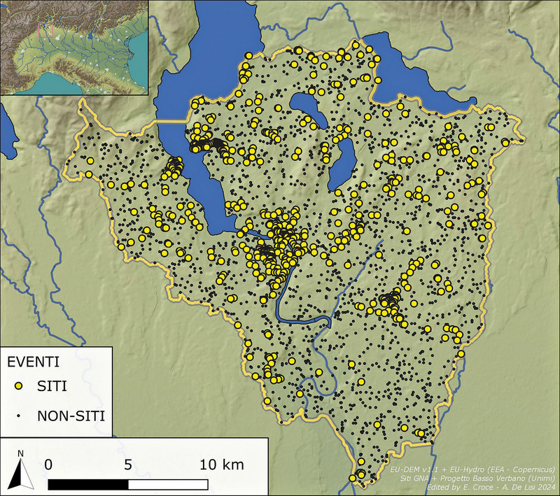 Academic Article“Looking for BVER into the GRASS”. Database pubblici e modelli predittivi in archeologia: il progetto BVER in dialogo con GNAThe work presented in this paper investigates the settlement dynamics of the Lower Verbano area between the Iron Age and the Middle Ages. The known archaeological sites, obtained from the public GNA database, were used along with a series of physical characteristics of the territory as variables for the calculation of an inductive predictive model. The results demonstrate the analytical potential of this methodology in the field of archaeological landscape analysis, highlighting also its shortcomings in strictly predictive terms. The model created for the general record of archaeological sites in the GNA proves to be underperforming from a predictive standpoint, whereas heterogeneous results were obtained when the sample of sites was selected chronologically. The model calculated for the Iron Age shows a high discriminatory power and, when compared to the models for the subsequent periods, under scores the importance of the selection of variables for this methodological approach. The use of data from a public database revealed several deficiencies in the management of complex territorial information inherent in its structure, but also highlighted the intrinsic potential of such a tool, which we hope to fully develop in the future.
 -
Academic Article“Let’s do it together!” Indagare, progettare, sviluppare la web archaeology con l’aiuto di un questionarioIn this paper the Author presents the results of a survey, which was created as a preliminary study that was part of the ARCA Project, a Ph.D. research project which started in November 2015. The purpose of the interview was to gather information about web sites related to archaeological projects and research, directly collecting feedback from users in order to analyze real world experiences and expectations. The questionnaire was prepared in collaboration with experts from other disciplines (psychologists, UX and UI experts, etc.), in order to promote an objective and scientifically valid approach, and obtain meaningful results. It is structured in 7 sections, for a total amount of 50 questions and practical experiences. One hundred and twenty people were invited to take part in this evaluation process; in a preliminary phase the interview was submitted to users coming exclusively from the Cultural Heritage Department of Padua University. Subsequently, it was opened to a wider audience from other universities and in other countries, to gather as much anonymous evidence as possible about functional feedback and user needs, also trying to map perception changes depending on origin, age, occupation and education. The collection and analysis of data allowed us to proceed further in the study and to develop software suitable for the presentation of different types of data from archaeological research. The final prototype will be evaluated through two case studies: the excavation of Nora and the Ca’Tron Project.
-
Academic Article“Field data collection app” e ricognizioni archeologiche: GeopaparazziThis paper aims to demonstrate how field data collection applications can represent a good resource in archaeological surveys. As an alternative to the classic paper documentation, using a smartphone application saves time both during the survey (automatic geolocation, GPS tracking) and in the post-processing (easier data import in a computer software, reduction of typo-errors and prevention of transcription errors). The focus of this paper is Geopaparazzi, an open source application for Android that allows customized and easy collection of field data by using a smartphone; collected data are ready to be processed by computer software like GIS. Geopaparazzi 6.1.0 was tested in four archaeological survey campaigns, three in Versilia (Italy, Tuscany) and one in Lampedusa (Italy, Sicily). The two environments are profoundly different: Versilia is a mountain landscape, and Lampedusa is a small island. Moreover, the data collected are different but these differences helped to understand how adaptable the application can be.
-
Academic Article“ArchaeoloGIS” a QGIS plugin for archaeological spatial analysisThe purpose of the paper is to introduce a QGIS plugin named ArcheoloGIS. It is developed in PYQGIS and tested by the community of Una Quantum Inc. (Italy). It consists of a decorator algorithm named Tabula Peutingeriana, that outputs points at a regular distance, every one Roman mile, along a given path. The article shows its use, the construction of a possible dataset and its evolution, as well as a case study of its application.
-
conference paper"Why Should I Trust You?": Explaining the Predictions of Any ClassifierDespite widespread adoption, machine learning models remain mostly black boxes. Understanding the reasons behind predictions is, however, quite important in assessing trust, which is fundamental if one plans to take action based on a prediction, or when choosing whether to deploy a new model. Such understanding also provides insights into the model, which can be used to transform an untrustworthy model or prediction into a trustworthy one. In this work, we propose LIME, a novel explanation technique that explains the predictions of any classifier in an interpretable and faithful manner, by learning an interpretable model locally varound the prediction. We also propose a method to explain models by presenting representative individual predictions and their explanations in a non-redundant way, framing the task as a submodular optimization problem. We demonstrate the flexibility of these methods by explaining different models for text (e.g. random forests) and image classification (e.g. neural networks). We show the utility of explanations via novel experiments, both simulated and with human subjects, on various scenarios that require trust: deciding if one should trust a prediction, choosing between models, improving an untrustworthy classifier, and identifying why a classifier should not be trusted.
-
Academic Article"Vox Domini": el órgano medieval del Museo del "Studium Biblicum Franciscanum" de Jerusalén y la perdida Sibila de la iglesia de la Natividad de BelénIn the Museum of the Studium Biblicum Franciscanum is preserved the Treasure of Bethlehem. It consists of a series of objects that belonged to the Church of Nativity in the medieval period. Among them it must be highlighted 251 organ pipes of various dimensions and a carillon consisting of 13 bells. This contribution proposes that the background of these pieces is related to the liturgical performance in the basilica during the Crusader’s times, in particular, the Chant of Sibyl on Christmas Eve. For that reason, it is very likely that this peculiar musical and dramatic context must be connected with the ornamentation of the church with mosaics, between 1167-1169, depicting both the Liber Generationis —in the main aisle— and the Tree of Jesse with the Sibyl, in the counterfaçade.
-
Academic Article"Progetto Calvatone": dallo scavo all’edizione multimedialeThe paper presents the project for the publication of archaeological excavations conducted from 2001 to 2006 by the University of Milan in collaboration with the University of Pavia at Calvatone-Bedriacum (CR), in the area of the Domus del Labirinto. The project proposes to test a new form of communication, which permits to offer complete information on the research carried out over the years. In particular, the project aims at a more effective and immediate form of communication, mediated by the use of a multimedia support such as the DVD, with the purpose of developing a functional model for the edition of any archaeological excavation. The innovative and experimental publication on DVD, made possible by the contribution of the Regione Lombardia (Assessorato alle Culture, Identità e Autonomie della Lombardia), has allowed us not only to present the analysis and interpretation of the excavations, through a large number of images, but also to provide the full documentation of the archive - inventories, recording sheets, photographs, drawings, plans - which is usually excluded from publication, for obvious problems of space and costs.
-
Academic Article"Mura Bastia". Dati archeologici, informatizzazione e rilievi 3D laser scanning del Castello degli Onigo (Pederobba, Treviso)This paper concerns computer applications for the management of archaeological data through GIS software, as related to the 2008 excavation campaign at “Mura Bastia”, Onigo (Treviso), Italy. The approach allows for the correlation of data previously acquired with those collected more recently using newer technologies. The shift from the traditional way of drawing archaeological records to the new digital technique began during the excavation of 2007. All of the walls and the layers were documented using a total station and a digital camera (photo-mosaic method). The elaboration of raw data was obtained using Free and Open Source Software only (GRASS, E-FOTO, GIMP, OPENJUMP, gvSIG). All of the new information levels (bi-dimensional raster and vector layers) were connected with the digitized plan of the old excavation into a GIS project that became the final product of the whole work. 3D terrestrial laser scanning surveys, integrated with classical topography and digital photogrammetric methodologies, allowed us to extract an accurate and photorealistic digital model of the Onigo castle. Moreover, a partial 3D virtual anastylosis of the tower was completed thanks to the reallocation of two missing elements in their correct position.
-
Book Section"Ludi circenses" en "Hispania": tipologías monumentales y testimonios iconográficosSemantic Scholar extracted view of ""Ludi circenses" en "Hispania": tipologías monumentales y testimonios iconográficos" by Trinidad Nogales Basarrate
-
Academic Article"L’intervisibilité": application à la région de la Tolfa-AllumiereThis article focuses on the organization of settlements in the Tolfa-Allumiere region (Lazio, Italy) in the Final Bronze Age and the beginning of the Iron Age. Our research follows a study on the occupation of La Castellina del Marangone, located about five km South of Civitavecchia, and its immediate environment. Many authors have already worked on this topic in Italy, but the originality of the present work is represented by the use of GIS tools to describe the spatial organization of this central Italy region. Each site is located on a Digital Elevation Model (DEM), providing a 2D or 3D view of the landscape. From this DEM, a set of dynamic maps was created detailing the conditions of landscape. In particular, the analysis of the topography makes it possible to evaluate the exposure in a given direction and to analyse notions of distance and costs of travel in order to define the possible existence of networks. The rivers certainly played a key role in the establishment of major trade routes and communication channels between the coastline and the most rugged Tolfa area. By using ArcGIS we can not only determine the overall field of vision but also the line of sight, in order to establish if the landscape obstructed the view between one site and another. Following this analysis and the creation of mapping funds, it was possible to answer the question concerning the reasons that led people to change their lifestyle and occupy the space throughout the Bronze Age.
-
Academic Article"Archeologia e Calcolatori": nuove strategie per la diffusione di contenuti in rete sulla base dell'OAI-PMHA project for digitalization and web diffusion of the journal «Archeologia e Calcolatori» contents has been recently started. While PDF seems to be the most satisfactory data format to deliver the electronic version of documents, international standards developed within the Open Archives paradigm can surely offer fascinating solutions to disseminate metadata describing their content. The most relevant protocol for Open Archives implementation is OAI-PMH. Several software applications to support OAI-PMH have been proposed by different institutions and some obtained a brilliant success. However, in certain situations the deployment of an OAI-PMH conformant repository is still problematic. The reason ranges from lack of technical expertise, cost of implementation and intrinsic complexity of web server administration. For small research institutions and university departments the most part of the existing OAI applications seems in effect not simple to implement. In this paper a simplified approach to OAI implementation for small and medium size archives is discussed. This project is based on an OAI Static Repository file (OAI-SR, i.e. an XML file based on a schema whose guidelines have been recently issued by OAI), Visual Basic, ASP, XML/XSL and Java technologies. It has been applied to the collection of abstracts coming from the articles published in «Archeologia e Calcolatori», but it can easily be adapted to other cultural subjects with small efforts.
-
Academic Article"Archeologia e Calcolatori": le ragioni di una sceltaAs Editor of the international Journal "Archeologia e Calcolatori", the author retraces the history of this editorial enterprise, which was established in 1989 by Mauro Cristofani and Riccardo Francovich. The Journal, which celebrates its 20th anniversary this year, is devoted to archaeological computing, a research sector characterised by the combining of information technologies with traditional archaeological methods. The path followed in the formulation of the editorial plan and its scientific coordination is reconstructed through various main stages: the reasons for the choice of the Journal’s title, its field of application and chronological range; the description of the contemporary international panorama, still characterised by isolated initiatives; the members of the international Scientific Committee, all representatives of the major Italian and foreign institutions; the scientific contents, with particular emphasis on the publication of special thematic issues and international conference proceedings; the archaeological computing bibliography, an information tool as well as a practical approach to systematising this young discipline. The present-day editorial policy of "Archeologia e Calcolatori" is dedicated to increasing the visibility and on-line diffusion of the Journal, and in this way furthering its original purpose: acquiring sources of information, as well as providing them.
-
Academic Article"Archeologia e Calcolatori": dieci anni di contributi all'informatica archeologicaThis article describes the research work which is now being carried out in order to classify bibliographic information, related to the field of computer applications in archaeology, that is published yearly at the end of «Archeologia e Calcolatori». During the examination, information was recorded in a database using Access software. For classification purposes, particular attention was devoted to the research topic dealt with in the publication, which was divided into two separate sections: “subject field classification” and “computer typology classification”. One example of the way in which it is possible to consult the database on-line is now available on the Internet site of this Journal. In conclusion, the author describes the results obtained from a statistical analysis of data from the 266 articles which have been published over the last ten years in «Archeologia e Calcolatori».
-
 Academic Article‘Ritorno a Vulci’. New tools for the study of the south-eastern necropolisesThe project ‘Ritorno a Vulci’ focuses on specific sectors of the south-eastern necropolis of Vulci, where excavations have been conducted since the 1800s. One of the primary objectives of this project is to create a dedicated WebGIS that will generate and manage new topographical documentation of the area. This will serve as a collaborative digital research platform, making document consultation more accessible and contributing to their preservation. Another significant digital project is ‘Vulci nel Mondo’ (VNM), which is conceived as a Virtual Museum. The Authors illustrate this highly versatile tool as an online space to bring together a permanent collection on Vulci. The standard virtual tour model is built on two key aspects: navigation, providing access to the collections and other information on the museum’s website, and interaction, simulating a physical space with which visitors can engage.
 -
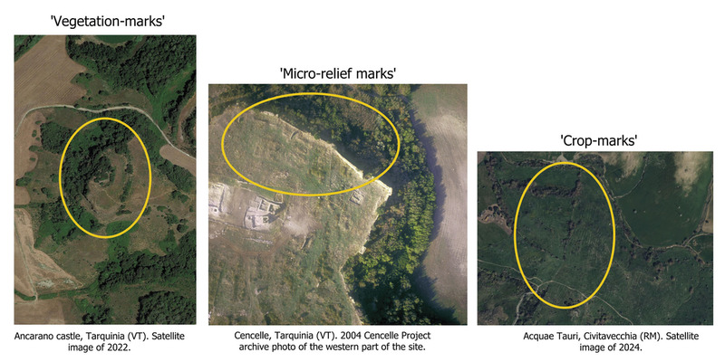 Academic Article‘Open’ architecture of UAVIMALS prototype and its archaeological useThe UAVIMALS system is a small airborne laser scanner prototype resulting from interdisciplinary research conducted by the Sapienza University of Rome and the Institute of BioRobotics of the Scuola Superiore S. Anna in Pisa. The project was financed by the National Geographic Society (Early Career Grant No. EC-50761T-18). Its aim was to develop an inexpensive and open source remote sensing system, test an engineered LiDAR sensor for autonomous vehicles, and create a specific aerial system for ‘micro-relief’ archaeological trace detection. The experiment conducted in the archaeological context of Leopolis-Cencelle (VT) demonstrated the effectiveness of a self-built open source hardware and software system that can be adapted to different types of archaeological visibility.
 -
Academic Article‘Buried Landscapes’ in Southern ItalyIt is widely known that war-time air photography has led to the discovery of many new archaeological sites of importance in Mediterranean lands. Many hundreds of tumuli have been added to the list, at such famous Etruscan cemeteries as Cerveteri and Tarquinia and complete systems of Roman land-partition by Centuriation have been identified round the coloniae of Iader and Salonae, on the shores of Dalmatia. But by far the most notable discoveries of all are those on the Foggia Plain, in the Province of Apulia, in Southeast Italy. Great numbers of Prehistoric, Roman, and Medieval sites are being identified, and some preliminary results have already been published in ANTIQUITY(' Siticulosa Apulia ', December 1946). Select examples were exhibited at the Classical Conference at Oxford and at the British Association Meeting, in 1948, and again for several months this year, in the Ashmolean Museum. These were chosen from a number which it was fortunately possible to acquire for the University of Oxford, now housed at the Pitt Rivers Museum, where they are being studied in detail. This collection was based on vertical photographs taken by the Royal Air Force, and oblique photographs taken by Major Williams-Hunt and myself (which were the first to reveal this dense concentration of sites, spread more thickly on the ground than almost anywhere else in Europe). This heavy concentration is of much more than local importance. During the last few years I have examined many thousands of air photographs of Southern and Central Europe taken at various seasons, in the course of my research. While these provide much interesting data and give us, as it were, an illustrated ' Domesday ' survey of Europe in the middle of the 20th century (of capital value to Anthropology), in no other area has there as yet been anything approaching the quantity of crop-marks, grass-marks, soil-marks and earthworks which have come to light in Apulia. There are various reasons for this and a detailed account must await a later report. For our present purposes, it will be enough to single out one or two areas, for comparison.
-
Academic Article'The Spade Might Soon Determine It': The Representation of Deserted Medieval Villages on Ordnance Survey Plans, 1849–1910From its earliest days the Ordnance Survey had an interest in recording the earthworks of antiquity. For the large-scale plans the information gathered from the surveyors in the field was supplemented by correspondence with knowledgable local scholars. The earthworks from medieval villages although numerous were generally ignored except for the East Riding of Yorkshire where, largely through the interest of Capt. John Bayly, RE, FSA (1821–1905), the first edition of the six-inch map detailed twentyfive sites. At the revisions of 1890–1909 the interpretation of these earthworks came into question: the replies of local correspondents, surviving in the OS archive, show considerable scepticism but the better-informed invoked documentary sources, while one –in a phrase embodied in the title of this article – urged abitration by excavation, a course which medieval archaeology has eventually followed.
-
Academic Article'Segeda Project': the I.T. management of the territory of a Celtiberian city-stateThis article defends the use of Geographic Information Systems (GIS) for the management, analysis, examination and modelling of the archaeological data concerning the territory. Within this context, we outline some types of analyses that are being carried out with the use of GIS applied to the case of Segeda. Drawing on these and other experiments, we conclude that GIS technologies and their well-established capacity for the integration, analysis and examination of information from different sources constitute a particularly effective tool for the modelling of complex realities such as the one we are concerned with in our project.
-
Book...presso l'Adige ridente"... Recenti rinvenimenti archeologici da Este a MontagnanaIl volume raccogliegli esiti di un decennio di ricerche nelle necropoli di Este, Casa di Ricovero tra VIII e III sec. a.C. e nelle necropoli e nell'abitato di Montagnana tra età del bronzo finale e primissima età del ferro
-
Book---Comunicazione e fruizione dei beni archeologiciLa scelta è stata di inserirci nel dibattito tanto intenso nel nostro tempo sulle politiche per i beni archeologici con alcune esperienze di azioni concrete che presentiamo senza la pretesa di proporre un metodo o un esempio da seguire. L’intenzione è stata di coniugare ricerca, didattica e lavoro sul campo, mettendo insieme idee e forze per individuare strade diverse da quelle che hanno visto nel settore dei beni archeologici concentrare risorse su alcuni siti, grandi attrattori, e lasciare altri, pure riguardevoli, nell’abbandono. Le esperienze che illustriamo sono maturate nell’ambito della Seconda Università di Napoli, nel corso di Conservazione dei Beni Culturali. Sono state volte a rispondere a responsabili richieste degli studenti, da noi condivise, di superare i limiti di una preparazione universitaria che le briglie delle riforme degli ordinamenti precipitosamente susseguitesi hanno teso a comprimere in numeri e crediti formativi. Ci ha mosso il convincimento che non si possono formare giovani incentrando la loro preparazione solo sulla conoscenza e conservazione, separandole dalla valorizzazione, fruizione e comunicazione dei beni: operazioni tutte che riguardano la cultura prima che la commercializzazione.