

Items
-
Academic ArticleThe road (not) taken. Reconstructing pre-modern roads in Viabundus. Methods and opportunitiesThe Viabundus pre-modern street map attempts to show medieval and early modern traffic connections. However, mapping medieval and pre-modern land routes comes with methodological challenges which are reflected upon in this paper. The reconstruction is based on written and archaeological sources, historical maps, and establishments of traffic infrastructure. Correlating the data with the origin places and finding places of pilgrim badges shows the research potential of the endeavor, as the simple co-visualization of the data already provides interesting connecting points.
-
BookThe River Qoueiq, Northern Syria, and its Catchment, Part ii: Studies arising from the Tell Rifa'at Survey 1977-79This volume is part of a two volume set: ISBN 9781407389530 (Volume I); ISBN 9781407389547 (Volume II); ISBN 9780860541172 (Volume set).
-
Academic ArticleThe Rise of Platinum Open Access Journals with Both Impact Factors and Zero Article Processing ChargesIt appears that open access (OA) academic publishing is better for science because it provides frictionless access to make significant advancements in knowledge. OA also benefits individual researchers by providing the widest possible audience and concomitant increased citation rates. OA publishing rates are growing fast as increasing numbers of funders demand it and is currently dominated by gold OA (authors pay article processing charges (APCs)). Academics with limited financial resources perceive they must choose between publishing behind pay walls or using research funds for OA publishing. Worse, many new OA journals with low APCs did not have impact factors, which reduces OA selection for tenure track professors. Such unpleasant choices may be dissolving. This article provides analysis with a free and open source python script to collate all journals with impact factors with the now more than 12,000 OA journals that are truly platinum OA (neither the author nor the readers pay for the peer-reviewed work). The results found platinum OA is growing faster than both academic publishing and OA publishing. There are now over 350 platinum OA journals with impact factors over a wide variety of academic disciplines, giving most academics options for OA with no APCs.
-
Academic ArticleThe rights of reproducing Cultural Heritage in the digital Era. An Italian PerspectiveThe spread of digital technology has led to a renewed phase within the debate on property rights in Cultural Heritage reproduction. This topic is addressed in different ways, but it is currently under discussion both in Europe and USA. Italy holds a particular position in this debate, due to its large concentration of ancient remains and the peculiar structure of its laws. The interesting experiments of total open access to Cultural Heritage reproduction on the one hand, and claims of the State Administration for control of Cultural Heritage exploitation and a consequent income (in any sense) on the other, are equally valid arguments. At the same time the blurred distinction between the concepts of 'reconstruction' and 'reproduction', of 'personal' and 'commercial' use, and the philosophical and mathematical difficulties in defining what is exactly a 'copy' in the digital context, make the matter harder. The paper aims to analyse this debate, and to make a contribution to a new method of considering the economic dimension of Cultural Heritage, taking into account international discussion, while focusing on the situation in Italy, and trying to sum up the needs of the different subjects involved while expressing a proposal to resolve the problem.
-
BookThe Republican Aventine and Rome's Social OrderThe Aventine—one of Rome’s canonical seven hills—has long been identified as the city’s plebeian district, which housed the lower orders of society and served as the political headquarters, religious citadel, and social bastion of those seeking radical reform of the Republican constitution. Lisa Marie Mignone challenges the plebeian-Aventine paradigm through a multidisciplinary review of the ancient evidence, demonstrating that this construct proves to be a modern creation. Mignone uses ancient literary accounts, material evidence, and legal and semantic developments to reconstruct and reexamine the history of the Aventine Hill. Through comparative studies of premodern urban planning and development, combined with an assessment of gang violence and ancient neighborhood practices in the latter half of the first century BCE, she argues that there was no concentration of the disadvantaged in a “plebeian ghetto.” Thus residency patterns everywhere in the caput mundi, including the Aventine Hill, likely incorporated the full spectrum of Roman society. The myth of the “plebeian Aventine” became embedded not only in classical scholarship, but also in modern political and cultural consciousness; it has even been used by modern figures to support their political agenda. Yet The Republican Aventine and Rome’s Social Order makes bold new claims regarding the urban design and social history of ancient Rome and raises a significant question about ancient urbanism and social stability more generally: Did social integration reduce violence in premodern cities and promote urban concord?
-
Academic ArticleThe Reliability and Validity of a Lithic Debitage Typology: Implications for Archaeological InterpretationSullivan and Rozen's (1985) debitage typology has been proposed as a method for measuring the effects of variation in lithic reduction by describing “distinctive assemblages.” This is in contrast to many traditional analytical methods oriented toward identifying the effects of lithic reduction techniques on individual flakes. Debate over the use of the typology has focused primarily on the ability of the typology to accurately measure variation in lithic reduction behavior, and secondarily on the role of experimental studies in archaeology. In this paper I present an analysis designed to estimate the reliability and validity of the typology. An experimental design is developed to permit data collection with minimal analyst induced random or systematic error. Principal components analysis and the coefficient theta demonstrate that the typology provides reliable or replicable results when applied to debitage assemblages of similar technological origin. Further principal components analysis suggests that the instrument is of limited utility in recognizing effects of variation in reduction activities associated with highly vitreous lithic raw materials. A means of expanding the typology and increasing its accuracy in archaeological pattern recognition is presented., RésuméLa tipología de los restos líticos de Sullivan y Rozen (1985) ha sido propuesta como un método por medir el efecto de la variabilidad en “reducción distintiva” de cada conjunto. Este mótodo contrasta con otros mátodos analitícos tradicionales, que están orientados a la identificción de los efectos de las técnicas de reducción lítica en las lascas individuates. El debate sobre los usos de la tipología se har enfocado primeramente en la abilidad de la tipología para de tectar exactamente la variación en el proceso de reducción lítica, y segundamente en elpapel de los estudios arqueológicos experimentales. En este artículo, presento un análisis diseñado para estimar la confiabilidad y validez de la tipología. Un diseho experimental estd desarollado para permitir lafue colleción de datos con un mmímo de errores inducidos casual y sistematicamente. La análisis de los componentes principales y el coeficiente theta demuestra que la tipología produce resultados confiables y reproducible cuando se aplica a conjuntos de restos de origen tecnico similar. El andlisis adicional de los componentes principales sugiere que la tipología es de utilidad limitada para reconocer los efectos de variación en actividades de reducción. Este papel amplía la tipologia y aumenta la precisión para reconocer patrones arqueológicos.
-
Academic ArticleThe rediscovery of colors at Kainua-MarzabottoThe study of the Attic-figured pottery is closely connected with the ‘Beazley method’, which consists in the possibility of recognizing a painting ‘hand’ exclusively based on the style of the work; the Beazley method, despite having suffered some criticism, is still considered substantially valid. The need to have images which can be analyzed from a stylistic point of view, has suggested to combine the use of some open-source programs of 3D photogrammetry (such as VisualSFM and Meshlab) and 3D modeling (such as Blender), in order to shift the figured frieze from the pot to paper, avoiding the limitations associated with traditional direct drawing.
-
BookThe Red and the Black. Social and Cultural Interaction between the Upper Euphrates and the Southern Caucasus Communities in the fourth and third Millennium BC.The Red and the Black. Social and Cultural Interaction between the Upper Euphrates and the Southern Caucasus
-
Academic Article
-
Academic ArticleThe quantification of spatio-temporal distributions of archaeological data: from counts to frequenciesTraces of past social actions, detectable in the archaeological record, are the material evidence through which we can infer social and economic patterns of ancient societies. These categories can be investigated in both time and space using a probabilistic statistical approach. In an attempt to quantify the results of archaeological processes we distinguish the terms of count and frequency, which is not common in archaeology, focusing particularly on the latter. In this framework we are able to calculate the number of times a certain event took place in relation to the length of the time interval during which the event is repeated. In addition, the statistical tools allow us to understand if the observable material evidence is the result of a particular archaeological phenomenon (accumulation) that can fit a statistical distribution or process (Poisson process and multivariate normal distribution).
-
Academic Article
-
Academic ArticleThe Qanāt: a multidisciplinary and diachronic approach to the study of groundwater catchment systems in archaeologyThe qanāt, as a traditional, low-cost, sustainable, water distribution system, was fundamental for the settlement of arid environments. This brief introduction to the special issue “The Qanāt: Archaeology and Environment” presents an overview of a workshop of the same name, held at Durham University in October 2014, and introduces the key themes that are explored through the papers in this volume. It also lays out the basis of an interdisciplinary research agenda for qanāt studies in archaeology.
-
Academic Article
-
BookThe Promise and Peril of Big DataEver-rising floods of data are being generated by mobile networking, cloud computing and other new technologies. At the same time, continued innovations use advanced correlation techniques to analyze them, and the process and payoff can be both encouraging and alarming. The Promise and Peril of Big Data explores the ways these inferential technologies can positively affect medicine, business and government, and also examines the social perils they pose. Written by conference rapporteur David Bollier, the report summarizes the insights of the Eighteenth Annual Roundtable on Information Technology, which sought to understand the implications of the emergence of "Big Data" and new techniques of inferential analysis.
-
Academic ArticleThe Promise and Challenge of Archaeological Data IntegrationThis forum reports the results of a National Science Foundation—funded workshop that focused on the integration and preservation of digital databases and other structured data derived from archaeological contexts. The workshop concluded that for archaeology to achieve its potential to advance long-term, scientific understandings of human history, there is a pressing need for an archaeological information infrastructure that will allow us to archive, access, integrate, and mine disparate data sets. This report provides an assessment of the informatics needs of archaeology, articulates an ambitious vision for a distributed disciplinary information infrastructure (cyberinfrastructure), discusses the challenges posed by its development, and outlines initial steps toward its realization. Finally, it argues that such a cyberinfrastructure has enormous potential to contribute to anthropology and science more generally. Concept-oriented archaeological data integration will enable the use of existing data to answer compelling new questions and permit syntheses of archaeological data that rely not on other investigators' conclusions but on analyses of meaningfully integrated new and legacy data sets., RésuméEste foro reporta los resultados de un taller auspiciado por la Fundación Nacional para las Ciencias (National Science Foundation), el cual se enfocó en la integración y conservación de las bases de datos digitales y de otros datos estructurados derivados de los contextos arqueológicos. Este taller llegó a la conclusión de que para que la arqueología alcance su potencial de avanzar en el entendimiento científico de la historia humana a largo plazo, hay una apremiante necesidad de que exista una infraestructura de información arqueológica que nos permita alcanzar, acceder, integrar, y extraer bases de datos diferentes. Este informe proporciona una evaluación de las necesidades informáticas de la arqueología, articula una visión ambiciosa para establecer una infraestructura de información disciplinaria distribuida (ciberinfraestructura), discute los retos presentados, y esboza los pasos iniciales hacia su realización. Finalmente, argumenta que dicha ciberinfraestructura tiene un enorme potencial de contribuir a la antropología y más generalmente a la ciencia. La integración de los datos arqueológicos orientados a los conceptos permitirá el uso de los datos existentes para resolver nuevas preguntas obligadas y conformar síntesis de los datos arqueológicos que se basan no en las conclusiones de otros investigadores sino en los análisis de bases de datos nuevas y heredadas integradas significativamente.
-
conference paperThe principles of the seville charterNowadays the worldwide application of computer-based visualisation in the field of archaeological heritage may be described as full of "lights and shadows". The spectacular growth of cultural tourism and the amazing technological advances in recent years have led to the development and implementation of a myriad of projects to investigate, preserve, interpret and present various elements of archaeological heritage using computer-based visualisation.
-
Book SectionThe princely cart from EretumThe authors present a detailed description of the project of the virtual reunification and recontextualisation of the grave goods found in a tomb of the Sabine necropolis of Colle del Forno, which held a princely burial: archaeological research, technical analyses, restoration, 3D reconstruction of the cart found inside the tomb and of its bronze decoration, and virtual reconstitution of the grave goods – constituted both by local products and objects imported from the Orient, as well as by two wheeled vehicles: a cart and a chariot) – in the framework of their original archaeological and cultural context. Besides a DVD, which shows a video at the Ny Carlsberg Glyptotek in the room containing the exhibition of the cart and other objects from the tomb, a web site has been created (http://www.principisabini.it/): the web visitors can reconstruct the history of the discovery, walk through this 7th-6th century BC tomb, see the structural and functional mechanisms of the cart in action, and enjoy this Italic masterpiece.
-
Academic ArticleThe pricing of open access journals: Diverse niches and sources of value in academic publishingOpen access (OA) publishing has created new academic and economic niches in contemporary science. OA journals offer numerous publication outlets with varying editorial philosophies and business models. This article analyzes the Directory of Open Access Journals (DOAJ) (n = 12,127) to identify characteristics of OA academic journals related to the adoption of article processing charge (APC)-based business models, as well as the price points of journals that charge APCs. Journal impact factor (JIF), language, publisher mission, DOAJ Seal, economic and geographic regions of publishers, peer review duration, and journal discipline are all significantly related to the adoption and pricing of journal APCs. Even after accounting for other journal characteristics (prestige, discipline, publisher country), journals published by for-profit publishers charge the highest APCs. Journals with status endowments (JIF, DOAJ Seal) and articles written in English, published in wealthier regions, and in medical or science-based disciplines are also relatively costlier. The OA publishing market reveals insights into forces that create economic and academic value in contemporary science. Political and institutional inequalities manifest in the varying niches occupied by different OA journals and publishers.
-
Academic ArticleThe preregistration revolutionProgress in science relies in part on generating hypotheses with existing observations and testing hypotheses with new observations. This distinction between postdiction and prediction is appreciated conceptually but is not respected in practice. Mistaking generation of postdictions with testing of predictions reduces the credibility of research findings. However, ordinary biases in human reasoning, such as hindsight bias, make it hard to avoid this mistake. An effective solution is to define the research questions and analysis plan before observing the research outcomes—a process called preregistration. Preregistration distinguishes analyses and outcomes that result from predictions from those that result from postdictions. A variety of practical strategies are available to make the best possible use of preregistration in circumstances that fall short of the ideal application, such as when the data are preexisting. Services are now available for preregistration across all disciplines, facilitating a rapid increase in the practice. Widespread adoption of preregistration will increase distinctiveness between hypothesis generation and hypothesis testing and will improve the credibility of research findings.
-
Academic Article
-
Academic ArticleThe Potential of Unmanned Aerial Vehicle for Large Scale Mapping of Coastal AreaMany countries in the tropical region are covered with cloud for most of the time, hence, it is difficult to get clear images especially from high resolution satellite imagery. Aerial photogrammetry can be used but most of the time the cloud problem still exists. Today, this problem could be solved using a system known as unmanned aerial vehicle (UAV) where the aerial images can be acquired at low altitude and the system can fly under the cloud. The UAV system could be used in various applications including mapping coastal area. The UAV system is equipped with an autopilot system and automatic method known as autonomous flying that can be utilized for data acquisition. To achieve high resolution imagery, a compact digital camera of high resolution was used to acquire the aerial images at an altitude. In this study, the UAV system was employed to acquire aerial images of a coastal simulation model at low altitude. From the aerial images, photogrammetric image processing was executed to produce photogrammetric outputs such a digital elevation model (DEM), contour line and orthophoto. In this study, ground control point (GCP) and check point (CP) were established using conventional ground surveying method (i.e total station). The GCP is used for exterior orientation in photogrammetric processes and CP for accuracy assessment based on Root Mean Square Error (RMSE). From this study, it was found that the UAV system can be used for large scale mapping of coastal simulation model with accuracy at millimeter level. It is anticipated that the same system could be used for large scale mapping of real coastal area and produces good accuracy. Finally, the UAV system has great potential to be used for various applications that require accurate results or products at limited time and less man power.
-
Academic ArticleThe potential of new LiDAR datasets for archaeology in SwitzerlandLiDAR and its derived elevation models have revolutionized archaeological research in forested areas around the globe. Almost a third of Switzerland is covered in forests. The number of archaeological sites recorded in forests in Switzerland is, however, limited. Given these circumstances, it is surprising how underutilized LiDAR data are in archaeological research in the country. As the Federal Office of Topography swisstopo is finalizing the acquisition of new LiDAR datasets, increasing the covered area and allowing for limited time series analyses, these data should be used to the fullest extent. This article describes the open access datasets and elaborates on their potential for archaeological research and cultural heritage management. By employing LiDAR data on a large scale, Swiss archaeological research would likely substantially increase the number of recorded heritage sites. Additionally, this will have the effect of complementing the palimpsests of past anthropogenic activity throughout the landscape while reducing survey biases in the archaeological record.
-
Academic ArticleThe potential of airborne LiDAR for detection of archaeological features under woodland canopiesThe development of lidar opens a new era in archaeological survey. Working with Forest Research, staff of the Unit for Landscape Modelling here explain the technique, and demonstrate its application to woodland, showing how it can be used to see through the trees. The article by Bewley et al. (pages 636-647 of this volume) shows the technique applied to the Stonehenge landscape.
-
Academic ArticleThe potential and problems of volumetric 3D modeling in archaeological stratigraphic analysis: A case study from Chlorakas-Palloures, Cyprus3D digital recording technologies have become increasingly popular for rapid, cost-effective, and accurate archaeological documentation in the field. Despite improvements in 3D GIS software, three-dimensional reconstruction of archaeological stratigraphy has been slow to develop and is rarely utilized as a basis for spatial analysis post-excavation. This is partially owing to the technical and methodological challenges of creating accurate reconstructions of excavated stratigraphy, which restricts the analytical potential of 3D datasets. Volumetric 3D modeling could vastly improve how we understand and analyze archaeological deposits and stratigraphies by enabling a quantitative comparative analysis of per-volume density of artifact types between stratigraphic units. The presented case study examines the spatial articulation of the recorded stratigraphic units from three adjacent trenches excavated during the 2015–2017 field season at the Chalcolithic settlement site of Chlorakas-Palloures in Cyprus. Three vector-based 3D modeling methods using the existing 3D Analyst toolkit within the proprietary software ESRI ArcScene are evaluated for their effectiveness in volumetric representation of stratigraphy using total station (TS) data and photogrammetry models of archaeological features. The results of this study indicate that volumetric modeling can enhance the analytical potential of spatial data by visualizing and identifying patterns in excavated deposits and organizing and disseminating information about the excavation process in an intuitive, user-friendly interface. However, accurate volumetric modeling of all types of archaeological features requires a re-evaluation of conventional documentation procedures to capture the volume of excavated deposits rather than just the interfaces between them. Furthermore, efficient workflows using cost-effective and open source software must be developed to make this approach more accessible and effective for a wider archaeological community.
-
Book SectionThe Potential and Limits of Optimal Path AnalysisIn the last two decades an increasing number of archaeological least-cost path (LCP) studies have been published. LCP analysis recently has become part of the predictive modelling toolkit in American archaeology. Most archaeologists applying push-button LCP software are not aware of the limitations of Geographical Information Systems (GIS) functions. The chapter shows that standard GIS software lacks some features that are important in archaeological optimal path calculations. The developments of LCP analysis and cost-surface analysis in archaeology are closely connected, because, as mentioned, most LCP methods calculate an accumulated cost surface (ACS) as a first step. Dijkstra's algorithm selects one optimal path in the presence of several alternatives. Batten advocates starting with the simplest model, which, in nigged terrain, is based mainly on slope, and to refine this model if necessary after comparing the paths based on the simple model with the known or expected paths.
-
Book SectionThe Portraits of Herodes Atticus and His CircleThis chapter deals mainly with the portraits of Herodes Atticus and those of his foster sons, Polydeukion, Memnon and Achilles, set up by the sophist after their deaths. These portraits were made by Attic workshops and partially reflect the imperial portraiture of their time.
-
Academic ArticleThe Po di Adria, Frattesina and the Po Delta between the Middle-Recent Bronze Age and the Early Iron AgeThe Southern Verona Lowlands /High-Polesine territories, in the second part of the Sub-Boreal period were subject together with a large part of the Po Plain to continental climatic conditions, interrupted by damp oscillations (Löbben oscillation), finally marked by sub-arid terminal peaks. At the same time, the anthropic impact derived from a widespread dissemination of settlements in the lower Po Valley became increasingly consistent. The interaction of these factors is debited from the first significant changes in the fluvial regime of the Po River, a principal padanian artery already present in the area from the first half of the III millennium B.C., travelled by a northern branch that I have called Po di Adria 1. The evidences of these first hydrographic changes are the formation of new flood-channels, of crevasse-splays and the diversions of various stretches of river courses, now less stable than in the preceding phases (post-Canar I and Pre-Canova phase: EBA-MBA: XVII-XVI century B.C.). These first changes were followed by a phase of relative stability, which coincides with a stage (MBA-RBA) of maximum settlement expansion of the Terramare sites in the central-eastern Po Plain, during which we assist, especially in the range between the South Verona plain and the Upper-Middle Polesine deltaic region, a flowering of a network of sites connected to the main chiefdom site of Fondo Paviani. To the end of this phase, the first evidences of a deterioration of the densely settled Po Plain territories, accentuated by the overexploitation of the soils and by the subsequent collapse of the Terramare settlement system, are seized. Between the end of the Terramare cycle and the beginning of the successive settlement cycle of the Frattesina site (between RBA2 and FBA1) some further paleohydrographic and paleoenvironmental transformations are documented, the effects of which from the hinterland Low Verona/High Polesine plains extended to affect the most eastern belts of the deltaic-coastal system. It now captures (between RBA2 and FBA1) the transition from an environment with very sinuous canals, anastomized, surrounded by basins dominated by peats-marsh sedimentation, to sub-rectilinear canals with wide sandy meanders, to which is associated the construction of first and most evident stripes of natural banks: these new morpho-fluvial patterns mark the transition from the Po of Adria 1 to the Po of Adria 1/2. These evident paleohydrographic transformations are caused in large part by the confluence of a new Po branch – The Po di Poggio Rusco-Dragoncello-Sermide, a result of a great diversion of the Po river flow from the hydraulic node of Brescello-Guastalla, in the Po of Adria 1. This new asset give a more efficient configuration to the Po course , named Po of Adria 1/2. At the same time, an increase is observed in the progradations of the coastal bodies (dunes and beach ridges) favoured by the confluence of the discharge contributions of Adige River in the Po di Adria River. These new dynamics, due to the cutting and obliteration of a series of very sinuous meanders inherited from the previous period (Ceneselli and Campestrin meanders), influenced the disorganization and participated in a rapid obliteration of pre-existing anthropic canals network having delivery in the F. Tartaro, at the same time placing serious difficulties to the previous connections between the central site of Fondo Paviani and the Po delta, now connected through the Po di Adria branch alone. After a phase of strong reduction and generalized abandonment of the Terramare sites (advanced RBA2), followed, starting from the FBA1, a phase of rapid recovery and resettlement in the regime of the "new" Po branch, the Po of Adria 1/2, favoured by the establishment of new average climatic conditions, more dry than the previous ones. This more stable situation determined the optimal conditions for the Frattesina site foundation, located at the apex of the delta system originated from the contributions of the main Po branch of the time, now disjointed from the connection with the Adige river, in following the clogging for overflood of the Saline-Cona branch. These new conditions, for the recovery of a stable river structure "in almost-balanced equilibrium" for the Po of Adria, determined by the confluence of the Po di Poggio Rusco-Dragoncello-Sermide in the ancient Po of Adria 1, favoured the rapid rise of the transformation and exchange pole of Frattesina, a role that lasted almost continuously for the three centuries of FBA. At the beginning of the Iron Age (EIA1: IX-VIII century B.C.) there were even more traumatic and extensive paleoenvironmental changes of the previous ones, determined by the establishment of a climatic phase of oceanic-cold type, with dryness peaks (Göschenen I fluctuation). This climate change reflected in the increase in the aggradation level of river courses, which now show accentuated phenomena of superelevation of the riverbeds, followed by repeated successions of floodings and river breaches. To these disastrous paleohydrographical processes, there are associated evident alterations in the coastal lines morphology, caused by deep erosions associated with disturbances of marine-weather origin. All these processes will quickly lead to the overflood of the entire river tract of Po di Adria 2, which is shortly to undergo a complete avulsion of its flow near Castelmassa, culminated in the Sermide breach-flood, the formative episode of new branch of the Po di Ferrara (Po di Spina).
-
Academic ArticleThe Place of ComplexityThis article is an attempt to understand the increasing profile of complexity theory as a geography of dissemination. In the first part I suggest that complexity theory, itself a rhetorical hybrid, takes on new meanings as it circulates in and through a number of actor-networks and, specifically, global science, global business and global New Age. As complexity theory circulates in these networks, so it encounters new conditions, which generate new hybrid theoretical forms. In the second part of the article, I consider how complexity theory might be interpreted as the emergence of a new structure of feeling in Euro-American societies, which frames the future as open and full of productivity. The conclusion offers some words of warning.
-
Academic ArticleThe Perspective of the Instruments: Mediating CollectivityNumerous studies in the fields of Science and Technology Studies (STS) and philosophy of technology have repeatedly stressed that scientific practices are collective practices that crucially depend on the presence of scientific technologies. Postphenomenology is one of the movements that aims to draw philosophical conclusions from these observations through an analysis of human–technology interactions in scientific practice. Two other attempts that try to integrate these insights into philosophy of science are Ronald Giere’s Scientific Perspectivism (2006) and Davis Baird’s Thing Knowledge (2004). In this paper, these two approaches will be critically discussed from the perspective of postphenomenology. We will argue that Giere and Baird problematically assume that scientific instruments (a) have a determined function, and (b) that all human members of a scientific collective have immediate access to this function. However, these assumptions also allow them to offer a clear answer to the question how scientists can collectively relate to scientific phenomena. Such an answer is not yet (explicitly) formulated within the postphenomenological perspective. By adding a postphenomenological touch to the semiotic approach in Actor-Network Theory, we offer an account of how different individual human–technology relations are integrated into larger scientific collectives. We do so by showing that scientific instruments not only help constitute scientific phenomena, but also the intersubjectivity within such collectives.
-
Academic ArticleThe Patrimony Atlas of Seine-Saint-DenisThe Patrimony Atlas of Seine-Saint-Denis (north of Paris) is an information tool related to the archaeological, architectural and landscape patrimony of Seine-Saint-Denis, accessible on the Internet address http://www.atlas-patrimoine93.fr/. It is distributed by the Cultural Patrimony Service of the Department of Seine-Saint-Denis, and is registered in the National Patrimony Atlas project of the Ministry of Culture. It is organized into three categories. The documentation platforms gather: a geographical catalogue which includes 50 levels of information geographically referenced, which are free of copyrights and can circulate online; a bibliography with 3700 references classified according to borough, subject and time period; an iconographic catalogue with 2800 images, the issues of archaeological maps and patrimony inventory that collect and collate past data. The “territorial views” offer a rapid access to a selection of ancient maps that represent a selected point on the territory on a contemporary basis, like the Napoleonic cadastral tables. The “Documents” file gathers the documents in a PDF format: university projects, thematic studies, articles and monographs, methodologies, summary charts, as well as hypertext documents, a presentation of the evolution of the road network in the latter part of the 18th century, a “Mathériauthèque numérique” dedicated to construction materials, and an “Atlas des colleges” of Seine-Saint-Denis. In its present version (2.5.3, put online in March 2008), the Seine-Saint-Denis Patrimony Atlas receives between 12,000 and 14,000 hits per month.
-
Academic ArticleThe past, present and future of Registered ReportsRegistered Reports are a form of empirical publication in which study proposals are peer reviewed and pre-accepted before research is undertaken. By deciding which articles are published based on the question, theory and methods, Registered Reports offer a remedy for a range of reporting and publication biases. Here, we reflect on the history, progress and future prospects of the Registered Reports initiative and offer practical guidance for authors, reviewers and editors. We review early evidence that Registered Reports are working as intended, while at the same time acknowledging that they are not a universal solution for irreproducibility. We also consider how the policies and practices surrounding Registered Reports are changing, or must change in the future, to address limitations and adapt to new challenges. We conclude that Registered Reports are promoting reproducibility, transparency and self-correction across disciplines and may help reshape how society evaluates research and researchers.
-
Academic ArticleThe Paleolithic of the Iranian Plateau: Hominin occupation history and implications for human dispersals across southern AsiaThe biological and cultural evolution of hominins in Asia is a central topic of paleoanthropology. Yet, the Paleolithic archaeology of key regions of Asia, including the Iranian plateau, have not been integrated into human evolutionary studies. Here, we examine the prehistory of the Iranian plateau with a focus on Iran, one of the largest and archaeologically best-known countries in the region. After approximately eight decades of professional fieldwork on the Paleolithic in Iran, a broad outline of the occupation history of the region has been achieved, though significant gaps remain in understanding the evolution and behavior of hominins in the region. Here we examine the history of Paleolithic investigations, synthesizing key archaeological information from the Lower Paleolithic to the EpiPaleolithic, placing emphasis on archaeological sites with stratified deposits and dated finds. We collect and summarize information on site locations, chronologies, rare hominin fossils, the more common lithic assemblages, and scarce worked items and symbolic objects. Our study documents considerable chronological and archaeological gaps in the Lower Paleolithic record, although Acheulean sites with characteristic lithics are present signaling the early colonization of the region by early hominin ancestors. The early Middle Paleolithic is poorly known owing to dating lacunae, although more abundant evidence is available from younger sites after 50,000 years ago (ka), spanning the late Middle Paleolithic, the Upper Paleolithic and the EpiPaleolithic. The fossil and archaeological evidence indicates the presence of Neanderthals in the Iranian plateau and later, Homo sapiens. The distribution of Lower to EpiPaleolithic sites are examined here, indicating both overlaps and divergences in the use of geographic areas, while pointing to large-scale research gaps in archaeological coverage. Key dispersal models are summarized, illustrating alternative views on the routes of human expansions in the Late Pleistocene, and how the Iranian plateau situates relative to the Levant, Arabia and Central Asia.
-
Book SectionThe Paleolithic of IranAfter reviewing the history of research on the Paleolithic of Iran, this chapter examines the Lower (Acheulean), Middle (Levallois-Mousterian), Upper Paleolithic (Baradostian) and Epipaleolithic industries attested throughout Iran. The typology and chronology of the major lithic industries represented in Iran are discussed. Particular emphasis is placed upon evidence discovered by Iranian researchers since 2000.
-
BookThe Oxford Handbook of the Archaeology of Death and BurialThe Oxford Handbook of the Archaeology of Death and Burial reviews the current state of mortuary archaeology and its practice, highlighting its often contentious place in the modern socio-politics of archaeology. It contains forty-four chapters which focus on the history of the discipline and its current scientific techniques and methods. Written by leading, international scholars in the field, it derives its examples and case studies from a wide range of time periods, such as the middle palaeolithic to the twentieth century, and geographical areas which include Europe, North and South America, Africa, and Asia. Combining up-to-date knowledge of relevant archaeological research with critical assessments of the theme and an evaluation of future research trajectories, it draws attention to the social, symbolic, and theoretical aspects of interpreting mortuary archaeology.The volume is well-illustrated with maps, plans, photographs, and illustrations and is ideally suited for students and researchers.
-
Academic ArticleThe origins of the city. From social theory to archaeological descriptionThis paper will focus on the origins of the city. This subject has been studied in sociology, anthropology, history and geography, but there is not a unified approach. Our paper deals with the specific way social theory can be used in archaeology. We consider that a 'city' is a specific form of social space 'produced' by a series of social actions. However, this 'production process' cannot be described easily in archaeological terms. As a result, there is a deep gap between social theory concepts and archaeologically observable evidence. Today it is fashionable to speak about the unscientific nature of Archaeology and Social Science. This paper deals with this discussion, trying to create an observational theory to understand the process of city formation. We reject traditional positivist approaches of concept and reference, because of its simplicity. However, this fact does not mean that the analysis is impossible in scientific terms. We show how to use spatial statistics, probabilistic modelling and visualization technology in order to obtain a simulation of the spatial process, and then use the resulting model to build a representation of social theory in archaeological terms. In the paper we use the Italian city of Tarquinia as a case study. It is suggested that the origin of the city can be represented as a spatial process beginning with preliminary scattered villages, which join together forming bigger spatial units, which become attractive for the better geographical and geomorphologic conditions. The gradual consolidation of the main settlement in the best location is determined by the population growth, and the development of a new productive system and new social relationships.
-
BookThe Origins of Biblical Monotheism: Israel's Polytheistic Background and the Ugaritic TextsAccording to the Bible, ancient Israel's neighbors worshipped a wide variety of gods. In recent years, scholars have sought a better understanding of this early polytheistic milieu and its relation to Yahweh, the God of Israel. Drawing on ancient Ugaritic texts and looking closely at Ugaritic deities, Mark Smith examines the meaning of "divinity" in the ancient near East and considers how this concept applies to Yahweh.
-
Academic Article
-
Academic ArticleThe Origin and Diffusion of Qanats in Arabia: New Evidence from the Northern and Southern PeninsulaIn scattered areas of the Arabian Peninsula, beginning several centuries before the first Christian millennium and for several centuries after, public works efforts were mounted to convey water from mountain aquifers, via subsurface aqueducts, onto drier valleys and plains. These subterranean, gravity-driven filtration galleries, known generically as qanats, were transplanted across the Peninsula first by Persians, and later by others who borrowed their technology. Much scholarly work has been produced to account for their constructions in Iran, Oman, and many other countries throughout the world where qanats were eventually built. But this story of technological diffusion has been left with notable gaps. This paper offers a synthesis of the history of qanats from earlier studies, together with fresh evidence collected from 1993–1998 fieldwork in some of these ‘gaps’in the northern and southern Peninsula. This collation offers evidence of three distinct pathways of diffusion of qanat technology from Persia across Arabia, and discusses the current use and future of qanats throughout the region.
-
Academic ArticleThe organization of funerary space and arrangement of burials within the corridor-shaped Tomb LCG-2 at Dibbā al-Bayah, Musandam, Sultanate of OmanThe paper aims to provide a comprehensive overview of the primary burial patterns identified at the bottom of the collective tomb LCG-2 at Dibbā, showing homogeneous features and common customs. The burials are often accompanied by conspicuous grave goods dating to the final stages of the Early Iron Age.
-
Academic ArticleThe Ordnance SurveyThe connexion between Maps and Archaeology is of a very obvious and straightforward nature. All distributional problems must, for instance, be studied on maps. If we want to find out about the distribution of the beaker folk, we must plot on a map the finds of the beakers; or if we desire to learn the area covered by examples of the ‘lanternes des morts’, a map of France is essential; the same applies to the study of long barrows and to a very great variety of archaeological studies. Moreover, in a more restricted sense, maps of sites are of the essence of the study of antiquity; we cannot understand the strength of the defences of the ancient Jebusite city unless we pore over the map of the excavations on the spur of Ophel. The excavations of every site are unintelligible without an accompanying map. In a still more restricted sense, each ‘find’ requires to have its position stated by the three co-ordinates of map-making: namely, its distance north or south, east or west, from—and above or below—some datum point in the excavations. Further, the maps themselves may furnish the only record left of some relicof antiquity. And,lastly ,ancient maps—and our present-day maps will one day be ancient—are valuable records of the past, of the culture of the age they represent, of population, human distribution and settlement, and, to some extent, of the science and art of the times. It is much to be regretted that so little mapmaking was done in ancient days. We should give a good deal for accurate contemporary plans of Rome of the time of Nero or of the battle of Hastings. And how much more for a contemporary map of Jerusalem and its surrounding country, before the destruction of the Holy City by Titus !
-
Book SectionThe Order of the Nomes of Lower Egypt in Geographical ListsFrom the earliest example currently known in the beginning of the fourth dynasty, to the Roman period, the ancient Egyptians produced geographical lists to order the world around them. They listed and classified the different parts of the territory
-
Academic ArticleThe Oligopoly of Academic Publishers in the Digital EraThe consolidation of the scientific publishing industry has been the topic of much debate within and outside the scientific community, especially in relation to major publishers’ high profit margins. However, the share of scientific output published in the journals of these major publishers, as well as its evolution over time and across various disciplines, has not yet been analyzed. This paper provides such analysis, based on 45 million documents indexed in the Web of Science over the period 1973-2013. It shows that in both natural and medical sciences (NMS) and social sciences and humanities (SSH), Reed-Elsevier, Wiley-Blackwell, Springer, and Taylor & Francis increased their share of the published output, especially since the advent of the digital era (mid-1990s). Combined, the top five most prolific publishers account for more than 50% of all papers published in 2013. Disciplines of the social sciences have the highest level of concentration (70% of papers from the top five publishers), while the humanities have remained relatively independent (20% from top five publishers). NMS disciplines are in between, mainly because of the strength of their scientific societies, such as the ACS in chemistry or APS in physics. The paper also examines the migration of journals between small and big publishing houses and explores the effect of publisher change on citation impact. It concludes with a discussion on the economics of scholarly publishing.
-
Academic ArticleThe obsidian sources of eastern Turkey and the Caucasus: Geochemistry, geology, and geochronologyIt has been 25 years since the publication of the monograph L'obsidienne au Proche et Moyen Orient: Du volcan à l'outil (Cauvin et al., 1998) and, within it, Poidevin’s (1998) chapter that summarized all available geochemical and geochronological data for obsidian sources in Turkey and the Caucasus. It was a highly valuable resource to those of us working on Near Eastern obsidian sourcing in the early 2000s; however, an update is long overdue. Poidevin (1998) compiled 229 analyses for obsidian sources in eastern Turkey and the Caucasus, and while he recognized the importance of independent analytical data, he was also frustrated that the few available data obscured real differences in obsidian composition versus variation among the different analytical facilities. Today we are closer to Poidevin’s (1998) goal. Here I summarize more than 7300 elemental analyses for 58 geochemically distinct obsidian sources. For example, Poidevin (1998) had just two analyses for Meydan Dağ, a highly important obsidian source, whereas here I report consensus values for 22 elements in Meydan Dağ obsidian based on 423 analyses from 25 independent techniques and laboratories. Not all 58 of the known obsidian sources within this region, however, have been so well characterized, and it is clear that there remains work to be done.
-
Academic ArticleThe Nora Virtual Tour: an immersive visit in the ancient cityThe ancient city of Nora was a Phoenician, Punic and Roman settlement rising on a peninsula in the south-western coast of Sardinia. Since 1990, the University of Padova has been carrying on an interdisciplinary research project of excavation, architectural analysis, historical reconstruction and cultural promotion of tourism in this site. The excavations allow us to increase our knowledge of Middle Imperial Roman urban planning and to get a better understanding of the whole city and its history; the restoration of excavated monuments using gravels with different colours helps more than 60,000 tourists every year to recognize the function of different areas. In spite of this, visitors experience difficulty in understanding a landscape of ruins with barely visible evidence. Thus, a complete virtual reconstruction of the ancient city has become essential. 3D models of the Phoenician and Roman settlement have been developed, reshaping archaeological plans produced in 25 years by Universities that work in the site. The main monuments of the Roman city and the major crossroads have been rendered in greater detail, using sample-based textures that give a photorealistic effect and implementing the models with furniture and decorations selected through reliable sources of information. 3D reconstructions are now available for tourist groups led by a guide in the Nora Virtual Tour: stereoscopic images have been rendered and uploaded in an app for mobile headsets that provides immersive virtual reality for the users. The guide controls the devices with a tablet using a Bluetooth connection: at the beginning of the visit, the tourists can view equirectangular panoramas of the ruins taken from a helicopter, then they are accompanied to hot-spots where the ancient monuments are shown in an evocative Roman reconstruction.
-
conference paperThe new trend of 3D archaeology is … going 2D!This volume brings together all the successful peer-reviewed papers submitted for the proceedings of the 43rd conference on Computer Applications and Quantitative Methods in Archaeology that took place in Siena (Italy) from March 31st to April 2nd 2015. Altogether, within the four days of the conference 280 papers were presented in 48 sections divided into ten macro topics, 113 posters, 7 roundtables and 12 workshops. That number, in itself, has prompted a thought or two. Above all it says that CAA is very much alive and kicking, that it is in robust good health, and that it remains a wholly relevant force in the scientific community, fully engaged with the questions of the day, and a continuing focal point for the profession. All of that speaks well for the motto of CAA 2015: KEEP THE REVOLUTION GOING. Although the significance of the motto is obvious, it is worth some thoughts. Few would deny that in the past 30 years or so, digital technologies have profoundly revolutionised archaeology – in the office and laboratory, in the field and in the classroom. The progressive introduction of digital techniques in the archaeological process has of course led to a general increase in efficiency. But perhaps more importantly it has provided a spur to the discussion of methodology and through that has strongly influenced not only the way we go about things but also the outcomes that we have been able to achieve. The pioneering phase in the application of digital techniques in archaeological research has clearly been fruitful and today computer applications such as GIS, databases, remote sensing and spatial analysis as well as virtual and cyber archaeology are deeply embedded within our universities. This is all good, of course, but we must not assume that the task has been completed. An intrinsic revolutionary instinct towards technological development has been awakened. But it will only survive by virtue of the results that it brings about. Or using the words of our Chairman Prof Gary Lock: ‘Computers not only change the way we do things, but more importantly they change the way we think about what we do and why we do it’. The general thrust of this statement can be summed up and reinforced by recalling a quote from the philosopher Don Ihde, who has argued we should never forget that all technologies should be regarded as ‘cultural instruments’, which as well as strategies and methodologies implemented in our researches are also ‘non-neutral’. So KEEP THE REVOLUTION GOING! is a motto that lays stress on the need to maintain innovation in archaeology through technological advances. But innovation must have at its root the fostering of critical thought and the framing of new archaeological questions. So there is much work still to be done, and fresh challenges to be faced in the months, years and decades ahead. -from the introduction by Stefano Campana and Roberto Scopigno
-
BookThe nEU-Med project: Vetricella, an Early Medieval royal property on Tuscany’s MediterraneanThe nEU-Med project is part of the Horizon 2020 programme, in the ERC Advanced project category. It began in October 2015 and the University of Siena is the host institution of the project. The project is focussed upon two Tuscan riverine corridors leading from the Gulf of Follonica in the Tyrrhenian Sea to the Colline Metallifere. It aims to document and analyze the form and timeframe of economic growth in this part of the Mediterranean, which took place between the 7th and the 12thc. Central to this is an understanding of the processes of change in human settlements, in the natural and farming landscapes in relation to the exploitation of resources, and in the implementation of differing political strategies. This volume presents the multi-disciplinary research focussed upon the key site of the project, Vetricella, and its territory. Vetricella is thought to be the site of Valli, a royal property in the Tuscan march. It is the only Early Medieval property to be extensively studied in Italy. Located on Italy’s Tyrrhenian coast, the archaeology and history of this site provide new insights on estate management, metal production and wider Mediterranean relations in the later first millennium. Apart from reports on the archaeology, the finds from excavations and environmental studies, three essays consider the wider European historical and archaeological context of Vetricella. Future monographs will feature studies by members of the project team on aspects of Vetricella, its finds and territory.
-
BookThe Neo-Assyrian Empire in the Southwest: Imperial Domination and its ConsequencesThe Neo-Assyrian empire — the first large empire of the ancient world — has attracted a great deal of public attention ever since the spectacular discoveries of its impressive remains in the 19th century. The southwestern part of this empire, located in the lands of the Bible, is archaeologically speaking the best known region in the world, and its history is described in a plethora of texts, including the Hebrew Bible. Using a bottom-up approach, Avraham Faust utilises this unparalleled information to reconstruct the outcomes of the Assyrian conquest of the region and how it impacted the diverse political units and ecological zones that comprised it. In doing so, he draws close attention to the transformations the imperial take-over brought in its wake. His analysis reveals the marginality of the annexed territories in the southwest as the empire focused its activities in small border areas facing its prospering clients. A comparison of this surprising picture to the information available from other parts of the empire suggests that the distance of these provinces from the imperial core is responsible for their fate. This sheds new light on factors influencing imperial expansion, the considerations leading to annexation, and the imperial methods of control, challenging old conventions about the development of the Assyrian empire and its rule.Faust also examines the Assyrian empire within the broader context of ancient Near Eastern imperialism to answer larger questions on the nature of Assyrian domination, the reasons for its harsh treatment of the distant provinces, and the factors influencing the limits of its reach. His findings highlight the historical development of imperial control in antiquity and the ways in which later empires were able to overcome similar limitations, paving the way to much larger and longer-lasting polities. , The Neo-Assyrian empire — the first large empire of the ancient world — has attracted a great deal of public attention ever since the spectacular discoveries of its impressive remains in the 19th century. The southwestern part of this empire, located in the lands of the Bible, is archaeologically speaking the best known region in the world, and its history is described in a plethora of texts, including the Hebrew Bible. Using a bottom-up approach, Avraham Faust utilises this unparalleled information to reconstruct the outcomes of the Assyrian conquest of the region and how it impacted the diverse political units and ecological zones that comprised it. In doing so, he draws close attention to the transformations the imperial take-over brought in its wake. His analysis reveals the marginality of the annexed territories in the southwest as the empire focused its activities in small border areas facing its prospering clients. A comparison of this surprising picture to the information available from other parts of the empire suggests that the distance of these provinces from the imperial core is responsible for their fate. This sheds new light on factors influencing imperial expansion, the considerations leading to annexation, and the imperial methods of control, challenging old conventions about the development of the Assyrian empire and its rule.Faust also examines the Assyrian empire within the broader context of ancient Near Eastern imperialism to answer larger questions on the nature of Assyrian domination, the reasons for its harsh treatment of the distant provinces, and the factors influencing the limits of its reach. His findings highlight the historical development of imperial control in antiquity and the ways in which later empires were able to overcome similar limitations, paving the way to much larger and longer-lasting polities.
-
BookThe Neighborhoods of Augustan RomeThis volume investigates the neighborhoods of ancient Rome during the reign of the first Roman Emperor, Caesar Augustus (27 BCE-14 CE). Focusing on a group of neighborhood-based voluntary associations that were important political and social communities for the city's diverse population of slaves and ex-slaves, it locates the Augustan neighborhoods within the broader context of the history of Rome. John Bert Lott stresses their importance as physical and cultural divisions of the city and investigates the distinctive relationship between local neighborhoods and Augustus himself.
-
Book Section
-
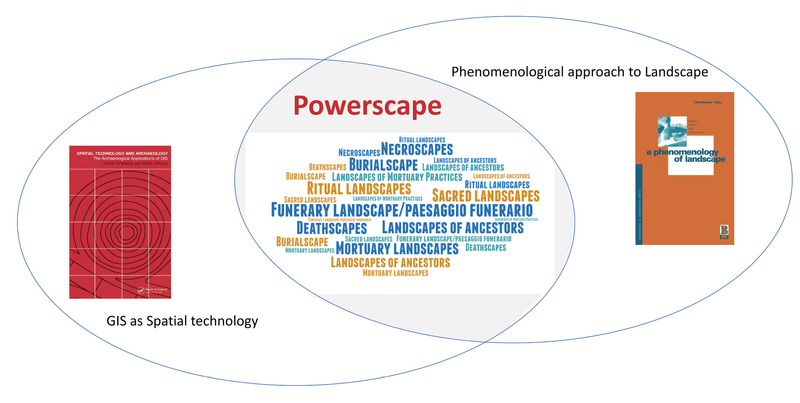 Academic ArticleThe necropolis as a landscape of power: some reflectionsThis paper focuses on some methodological approaches specific to digital archaeology in the analysis of a particular type of landscape, namely Etruscan-Italic necropolises. First, it highlights the interpretation of a necropolis as a landscape of ancestors and the importance of material and immaterial practices in the formation of such a space. Then it addresses the theoretical framework of phenomenological landscape analysis, developed in recent decades by C. Tilley, as a privileged way to address both aspects. In order to reconcile the phenomenological approach to landscape with the use of digital spatial technologies, which according to Tilley are insufficient because they are at best ‘representations’ of landscape, A. De Guio’s reading of the Powerscape concept is introduced. De Guio presents various spatial analysis algorithms, as fundamental ‘hammers’ to shape our knowledge of multifaceted landscapes such as powerscapes (an example of which is funerary landscapes). The reconciliation between the phenomenological approach to landscape and GIS-based spatial analyses of perceptual fields (especially vision and hearing) allows us to confidently rely on new perspectives, such as J. Ortoleva’s recent research on auditory perception in Etruscan necropolises or the latest approaches to viewshed analysis.
 -
Book SectionThe necropoleis: Tomb structuresThis volume brings together leading scholars of Etruria to provide up-to-date findings from the key archaeological site of Kainua. Located in what is now the Italian town of Marzabotto, Kainua is the only Etruscan site whose complete urban layout has been preserved, making it possible to trace houses, roads, drainage systems, cemeteries, craft workshops, and an acropolis.Under excavation since the 1850s, Kainua offers a trove of insights into Etruscan culture and society. The volume’s editor, Elisabetta Govi, and her fellow experts examine the material evidence underlying our understanding of the history, economy, religion, and social structures of Kainua, including trade routes that linked the city with the wider Mediterranean. Particularly exciting are recent discoveries of sanctuaries dedicated to Tinia and Uni, analogous to the Greek Zeus and Hera, which provide new information about Etruscan cults. Kainua (Marzabotto) also draws on the latest research to reconstruct the city’s foundation rites, a sacred charter, and urban plan. Finally, the authors explore the site’s archaeological history, discussing new knowledge made possible since the introduction of modern techniques of remote sensing and 3D modeling.
-
Academic Article
-
ThesisThe Monasteries of Jorgucat and Vanishtë in Dropull and of Spelaio in Lunxhëri as Monuments and Institutions During the Ottoman Period in Albania (16th-19th Centuries), Doctoral thesis submitted at the Centre for Byzantine, Ottoman and Modern Greek Studies,The present doctoral thesis is the outcome of a ten-year-long research project on churches and monasteries in the dioceses of the Orthodox Church of Albania. I first visited the district of Dropull in Southern Albania in 1992 and at once I was aston-ished to discover a large number of monasteries. Their presence in so tiny a district has prompted scholars to characterise Dropull as ‘Little Mount Athos’. In due course, I learned that other districts in Epiros and parts of Thessaly were also hosts to numerous monastic dwellings. The variety of roles played by the monasteries in Dropull was one of the incen-tives for my research. Until today, churches or monasteries of the post-Byzantine pe-riod have been the focus of specialists who have examined them either as monuments, from an architectural or an art historical point of view, or from a purely historical per-spective, as institutions. Attempts at cross-disciplinary approaches, however, have not hitherto been made. Neither were historians able to analyse or use architectural and art historical data, nor could architects or art historians interpret the primary historical sources in order to set in critical fashion the subject of their research in its historical context. Other studies that were confined to local phenomena but devoid of contextu-alization within general developments of Ottoman history, proved to be of limited im-portance to specialists dealing with other provinces of the empire. There remained a distinct vacuum in scholarship concerned with Church institutions. This work aspires to fill a part of the vacuum and three major issues are ad-dressed. First, the possibility of challenging the commonly-held view that the Ottoman state of the 15th and 16th century, with its centralised structures, constituted the ancestor of modern centralised democracies is investigated. In the light of the unique as I demonstrate findings in remote Albania, full centralisation was clearly neither desirable nor implemented. Secondly, a reconsideration of the various ‘catastrophe’ theories which classify the Ottoman period as ‘dark’ is undertaken. Thirdly, a macroscopic approach to the social, intellectual, religious and political roles of post-Byzantine monasteries is pursued. To respond to these issues I had to select carefully a sample region for research. Epiros and Albania were remote provinces of marginal though strategic importance for the Ottoman Empire; their histories are also an unexploited field for scholarly in-vestigation. Far from the Empire’s major centres of administration, they offered op-portunities for evaluating the power of the central government over them and for de-termining the degree of control exercised by the Ottoman state. Within these territo-ries, three monasteries, of the Prophet Elias in Jorgucat, the Annunciation in Vanishtë and the Nativity of the Virgin or Spelaio, Lunxhëri, provide quite representative yet preliminary points for research. For a start, all of them are located in the district of Gjirokastër and, comparatively speaking, relatively easy of access. Secondly, each monastery represents a different category of religious house. Jorgucat and Vanishtë were diocesan monasteries and of them the former became very wealthy in landed as-sets, while the latter remained relatively poor. Meanwhile, the Monastery of Spelaio was granted patriarchal and stavropegic status soon after its founding, a privilege that played an important part in the monastery’s life. Most of the post-Byzantine monaster-ies situated in remote districts of the empire could be classified into similar groupings. The gathering of my research material proved not to be an easy task. As peasant societies, such as Jorgucat, Vanishtë and Saraqinishtë, are bearers of a mostly oral cul-ture, they did not feel the urge to leave written records of their daily lives or activities. Furthermore, owing to the turbulent history of the regions of Southern Albania, the few related records were scattered in various places. Accordingly, in order to imple-ment the targets of this thesis, I was compelled to spread my research over a number of themes. In its initial stages I undertook lengthy field work, making prolonged visits to relevant sites. These research trips were carried out between July 1991 and October 2001 during which time I gathered data from churches and monasteries in Albania and Epiros and compared them at a later stage with the results of other field work undertaken by me in Aetolia, Thessaly and Southern Italy. To interpret my discoveries, I consulted primary sources and secondary literature in various museums, archives, libraries and research centres (for details, see the Acknowledgements). Initially, I made use of the resources in the Archives and Library of the Ecumen-ical Patriarchate, Istanbul; the General Archives of State in both Athens and Ioannina; the Byzantine Museums of Athens, Ioannina, Thessaloniki and Kastoria; the Demotik-on Museum, Ioannina; The State Hermitage Museum, Saint Petersburg; the Central Archives of State, Tiranë; the British School of Archaeology, Athens; the Archives of the Metropolis of Ioannina; the Archives of the Ministry of Foreign Affairs and those of the ÉóôïñéêÞ êáé ÅèíïëoãéêÞ Åôaéñåßá ÅëëÜäáò; the Archives of the Institutes of History and of Monuments, Tiranë; the National Libraries of Athens and Tiranë; the Library of the University of Birmingham; the Bodleian Library, Oxford; the British Library, London; the Archives of the Archdiocese of the Orthodox Church of Albania. Furthermore, I extended my research into private archives, such the archives and library of the late + Alexandros Mammopoulos, Athens; the archives of Philippos Giovannis, Ioannina; the archives of Thomas Pappas, Athens and the archives of G. Baras, Athens. Other bibliographical research was completed in the following specialised li-braries: the library of the Department of Byzantine and post-Byzantine art and archi-tecture, University of Ioannina; the libraries of the Εταιρεία Ηπειρωτικών Μελετών and the Ίδρυμα Βορειοηπειρωτικών Ερευνών and the library of the Ηπειρωτική Εταιρεία, Athens. The material of this thesis is divided into three major sections. The first, Chapter 1, sets out the historical context in which the monasteries under discussion were founded. Emphasis is laid on how the monasteries related to the adjacent villages and their societies and how they were affected by the major developments that occurred in the Ottoman Empire from the 16th to the 19th century. I attempt to demonstrate how the founding of these monasteries coincided with a period of demographic and eco-nomic growth for the various districts of Epiros and Albania. Furthermore, I indicate how church building and decorating activity were made possible only periods of rela-tive peace and stability and reflected the financial potential of the local communities. In the second section (Chapters 2 and 3) I deal with the monasteries as monu-ments, both from the architectural and art historical perspectives. In Chapter 2, the ca-tholica of the monasteries are classified according to architectural typologies. Special attention is paid to the catholicon of the Monastery of Vanishtë, one of the most im-portant post-Byzantine monuments in Epiros. Emphasis is also given to the several companies of masons, whose works can be identified in some of the monastic edifices as well as in other church buildings. I make the suggestion that henceforth scholarship needs to concentrate on the building activity of family groups of masons in a similar way to well-known workshops of painters. Attempt has been made to investigate the legal status of church building in the Ottoman period, as well as to investigate how so many new monasteries were built in spite of the related prohibitions of the Islamic Law and interpret this phenomenon. Chapter 3 surveys the wall paintings of the mon-asteries of Jorgucat, Vanishtë and Spelaio, especially in their early-17th-century phas-es, which were painted by the artist Michael from Linotopi. The artistic activity of the Linotopi artists in several districts of Albania is also explored in this chapter. Moreo-ver, indications of ideological trends in church painting from the region of Gjirokastër during the first half of the 17th century are also provided. Finally, the third section approaches these monasteries as institutions. Stress is laid on their social functions and contribution to education (Chapter 4), fiscal life and economic relations with the local community, state authorities and the local and cen-tral ecclesiastical authorities (Chapter 5). Chapter 4 indicates that the monasteries in Epiros and Albania were closer to the more ‘social’ type of monasticism as introduced by St Basil the Great and reinforced by monasteries in Constantinople. Albeit, the var-ious social and educational roles that the monasteries played, apart from these that they played by their very being (fulfilling the people’s religious needs, offering chanc-es for social events) appeared not to be voluntary or conscious efforts. The few excep-tions pointed out in this chapter indicate either personal initiatives of individual cler-gymen, or conscious but unsystematic efforts of the Ecumenical Patriarchate to exploit monastic wealth for educational activities. Indeed, in spite of the numerous monastic schools that are said to have functioned until the 18th century and, in some instances, up to the 19th century, the monasteries in Epiros and Albania appeared to be more of-ten concerned for financial, than spiritual, social or pedagogical matters. The few, bright exceptions or the indications of paedagogical activity as revealed by indirect in-formation do not suffice to reverse the impression of them being the initiative of indi-vidual, enlightened clergymen. Finally, Chapter 5 explores the financial potential of the peasant Epirote societies in connection with the erection, painting, repairing or ex-panding projects of their monasteries, including their tax obligations to the Ottoman state and the Church. Furthermore, it surveys the background of the monasteries’ pa-trons and correlates it with estimations of the costs of the projects in which they were involved. Moreover, it values the sources of monastic income and expenses, to con-clude that the monasteries were rather rich entireties with vast tracts of lands, but, generally, with properties so dispersed that they were difficult to manage by anyone, not to mention monks, whose vocation is irrelevant to managing properties. The relat-ed research, however, showed that the monasteries were quite keen on exploiting some of their properties. In spite of monastic claims of poverty in the 19th century, there are clear indications that the monasteries retained good parts of their estates until they were confiscated by the Greek and Albanian state. However, more often than not, the increase of the monastic property had a beneficial effect to the local societies in that monastic property was of communal usufruct. The present thesis resolves a number of problems and poses new ones. First, it demonstrates that the monasteries in Epiros and Albania were, above all, integral parts of their peasant communities’ mode of existence. Secondly, it shows that the local, peasant communities in these regions enjoyed a considerable degree of autonomy, a fact which challenges earlier suppositions about the strict centralised operation of the Ottoman administrative machine in the 15th and 16th centuries. Thirdly, judging from the number of church monuments that were built and painted, the 16th and early 17th centuries can no longer be considered a ‘dark’ period. Finally, this thesis demonstrates what was hitherto common, but unsubstantiated, wisdom about monasteries: that the roles they played and the functions they performed were considerable and varied. Taken in isolation, this thesis cannot give answers to general problems; it suffices, however, to point out that there is a need for more specialised studies in this fascinat-ing area of research. Finally, it underscores the need for a global approach to the mon-asteries, both as monuments and as institutions. As a contribution to post-Byzantine monasteriology, this thesis attempts to open horizons in Church history during the Ot-toman period. For the purposes of linguistic transliteration and geographic identity I was guid-ed by practicality and convenience. With place-names, I used ‘Greek’ versions for lo-calities situated in today’s Greece and Albanian for those in modern Albania (as seen in official maps). On occasion, however, when a particular Albanian name has no long-standing tradition, as in the case of ecclesiastical districts, I use historical toponyms. Thus, Gjirokastër becomes Argyrokastron when reference is made to the title of the ecclesiastical authority (e.g. Metropolis of Argyrokastron). Furthermore, with respect to the transliteration of Greek words into English I follow the established rules cited in Konstantopoulos G. P., New English Greek and Greek English Dictionary, Athens, p. 434i-ii. When it comes to people’s names, however, I follow the contemporary, official rules of transliteration appropriate to the language in question. Thus, the letter ‘ç’, which in the case of most common nouns is given as ‘e’, becomes an ‘i’ for names and surnames (e.g. Varsamidis). Owing to technical difficulties with my Word processor (Word 6.0 for Windows 3.1) it was not possible for me to type the differently accented ‘c’ in Serbian words.
-
Academic ArticleThe Minoan peak sanctuary landscape through a GIS approachThe research project, 'Building a cultural landscape model of Minoan peak sanctuaries through a GIS approach', based on a collaboration between the Institute of Mediterranean Studies (F.O.R.T.H.) and the Université Catholique de Louvain, aims to redefine the peak sanctuary, to clarify its function, and examine the relationship between the cultural and natural variables, which characterize the distribution of these sites in the Cretan landscape. To accomplish these goals we used advanced mapping techniques, satellite remote sensing, statistical analysis and Geographical Information Systems (GIS). Intervisibility was investigated with viewshed analysis. A chronological evolution of the peak sanctuary landscape is proposed, explaining the location of the sanctuaries, in relationship to each other and other site types.
-
conference paperThe methodology of documenting cultural heritage sites using photogrammetry, UAV, and 3D printing techniques: the case study of Asinou Church in CyprusAs the affordability, reliability and ease-of-use of Unmanned Aerial Vehicles (UAV) advances, the use of aerial surveying for cultural heritage purposes becomes a popular choice, yielding an unprecedented volume of high-resolution, geo-tagged image-sets of historical sites from above. As well, recent developments in photogrammetry technology provide a simple and cost-effective method of generating relatively accurate 3D models from 2D images. These techniques provide a set of new tools for archaeologists and cultural heritage experts to capture, store, process, share, visualise and annotate 3D models in the field. This paper focuses on the methodology used to document the cultural heritage site of Asinou Church in Cyprus using various state of the art techniques, such as UAV, photogrammetry and 3D printing. Hundreds of images of the Asinou Church were taken by a UAV with an attached high resolution, low cost camera. These photographic images were then used to create a digital 3D model and a 3D printer was used to create a physical model of the church. Such a methodology provides archaeologists and cultural heritage experts a simple and cost-effective method of generating relatively accurate 3D models from 2D images of cultural heritage sites.
-
Academic ArticleThe MedAfriCarbon Radiocarbon Database and Web Application. Archaeological Dynamics in Mediterranean Africa, ca. 9600–700 BCThe MedAfriCarbon radiocarbon database and its accompanying web application are outcomes of the MedAfrica project — Archaeological deep history and dynamics of Mediterranean Africa, ca. 9600–700 BC. The dataset presented here in Version 1.0 of the database includes 1587 archaeological 14C dates from 368 sites in Mediterranean Africa. The database is unusual because the majority of the dates within it have been annotated with further cultural and environmental variables, notably the presence/absence of different domestic/wild species and particular material culture traits. MedAfriCarbon also includes an publicly-accessible web application that facilitates data exploration and informal analysis. Funding statement: The Leverhulme Trust provided the core funding for the Archaeological deep history and dynamics of Mediterranean Africa, ca. 9600–700 BC (MedAfrica) Research Project (RPG-2016-261). Additional financial support for the project came from the McDonald Institute for Archaeological Research, Italian Ministry of Foreign Affairs and International Cooperation, and IPOCAN, MIUR project, via ISMEO (the International Association for Mediterranean and Oriental Studies). ISMEO financially covered the publication costs of this open-access paper.
-
BookThe Materiality of Stone: Explorations in Landscape PhenomenologyWith Wayne Bennett From the silky wax qualities of the surfaces of some quartz menhirs to the wood-grain textures of others, to the golden honeycombed limestones of Malta, to the icy frozen waves of the Cambrian sandstone of south-east Sweden, this book investigates the sensuous material qualities of stone. Tactile sensations, sonorous qualities, colour, and visual impressions are all shown to play a vital part in our understanding of the power and significance of prehistoric monuments in relation to their landscapes. In The Materiality of Stone, Christopher Tilley presents a radically new way of analyzing the significance of both 'cultural' and 'natural' stone in prehistoric European landscapes. Tilley's groundbreaking approach is to interpret human experience in a multidimensional and sensuous human way, rather than through an abstract analytical gaze. The studies range widely from the menhirs of prehistoric Brittany to Maltese Neolithic temples to Bronze Age rock carvings and cairns in southern Sweden. Tilley leaves no stone unturned as he also considers how the internal spaces and landscape settings are interpreted in relation to artifacts, substances, and related places that were deeply meaningful to the people who inhabited them and remain no less evocative today. In its innovative approach to understanding human experience through the tangible rocks and stone of our past, The Materiality of Stone is both a major theoretical and substantive contribution to the field of material culture studies and the study of European prehistory.
-
conference paperThe mapKurator System: A Complete Pipeline for Extracting and Linking Text from Historical MapsScanned historical maps in libraries and archives are valuable repositories of geographic data that often do not exist elsewhere. Despite the potential of machine learning tools like the Google Vision APIs for automatically transcribing text from these maps into machine-readable formats, they do not work well with large-sized images (e.g., high-resolution scanned documents), cannot infer the relation between the recognized text and other datasets, and are challenging to integrate with post-processing tools. This paper introduces the mapKurator system, an end-to-end system integrating machine learning models with a comprehensive data processing pipeline. mapKurator empowers automated extraction, post-processing, and linkage of text labels from large numbers of large-dimension historical map scans. The output data, comprising bounding polygons and recognized text, is in the standard GeoJSON format, making it easily modifiable within Geographic Information Systems (GIS). The proposed system allows users to quickly generate valuable data from large numbers of historical maps for in-depth analysis of the map content and, in turn, encourages map findability, accessibility, interoperability, and reusability (FAIR principles). We deployed the mapKurator system and enabled the processing of over 60,000 maps and over 100 million text/place names in the David Rumsey Historical Map collection. We also demonstrated a seamless integration of mapKurator with a collaborative web platform to enable accessing automated approaches for extracting and linking text labels from historical map scans and collective work to improve the results.
-
Book SectionThe map as assemblage: Landscape archaeology and mapworkThis chapter explores the idea of maps as assemblages. We pose three questions: What is it that maps represent? What is that maps do? How do maps produce
-
BookThe Making of the Middle Sea: A History of the Mediterranean from the Beginning to the Emergence of the Classical WorldThe Mediterranean has been for millennia one of the global cockpits of human endeavour. World-class interpretations exist of its Classical and subsequent history, but there has been remarkably little holistic exploration of how its societies, culture and economies first came into being, despite the fact that almost all the fundamental developments originated well before 500 bc. This book is the first full, interpretive synthesis for a generation on the rise of the Mediterranean world from its beginning, before the emergence of our own species, up to the threshold of Classical times. Extensively illustrated and ranging across disciplines, subject matter and chronology from early humans and the origins of farming and metallurgy to the rise of civilizations Egyptian, Levantine, Hispanic, Minoan, Mycenaean, Phoenician, Etruscan, early Greek the book is a masterpiece of archaeological and historical writing.
-
Academic ArticleThe LCG2 complex at Dibbā (Musandam, Oman, II—I millennium BC): structural, material, and osteological elementsThe Dibbā burial complex, represented by two 'long collective graves' (LCG1 and LCG2), a later Parthian grave, and several pits with ritual offerings, is located on the eastern coast of the Musandam peninsula, Sultanate of Oman. The paper mainly deals with LCG2. When all the external features are taken into account, LCG2 is a 23 m-long and 4.5 m-wide structure, which was built using different techniques and employing both local stones and mud brick. The whole area seems to have been continuously occupied from the Late Bronze Age (1600-1350 BC) until the Iron Age II/III period (c.600 At present, twenty-eight individuals from primary burials and a minimum number of 202 individuals from secondary depositions were found, accompanied by thousands of valuable objects (stone vessels, pottery vessels, and a wide variety of ornaments). Many phases of use have been identified, as well as different phases of restoration and rearrangement. An analysis of faunal remains retrieved in association with bone clusters was also carried out. Excavation of LCG2 has yet to be completed. Preliminary results, however, suggest that the area could have been a monumental tribute to tribal alliance dating to the end of the second millennium BC.
-
Academic ArticleThe last ten years of research at TarquiniaThe Centro di Ricerca Coordinata ‘Progetto Tarquinia’ of the Università degli Studi di Milano is a LERU (League of European Research Universities) exemplary interdisciplinary research project that involves groups from the Università Statale di Milano (Archaeology, Information and Communication Technologies, Geoarchaeology, Palaeoanthropology), the Politecnico di Milano (Architecture and Topography) and bridges the gap between soft and hard sciences. This project stems from the ‘Progetto Tarquinia’ conceived by Maria Bonghi Jovino in 1982. During the last ten years, our integrated system of tools and services, supported by ICTs (ArchMatrix), through which multidisciplinary domain experts can examine all the typologies of data of a given culture, has made it possible to concentrate on the links between data-sources focusing on the recurrence of association rates within different aspects of material evidence and phenomena. The fields of application of our methodology in the domain of archaeology and epigraphy are multifaceted as regards the inside and outside connections of the Tarquinian heritage, whose necropolis with the famous painted tombs is a UNESCO World Heritage Site. Research includes areas of the Civita plateau: the ‘monumental complex’, the Ara della Regina sanctuary, fortifications, and archaeological sites previously explored. In the past ten years, research in the necropolis (roughly 6,000 tombs, of which 400 are painted) and in the surrounding territory has also been implemented and has produced the complete corpus of the painted tombs of Tarquinia. Our holistic approach encompasses archaeological analysis of small (mobile finds), medium (archaeological contexts) and large scale (territory and landscape) architectural analysis and applications for integrated solutions for the cultural heritage, including the first bilingual Virtual Museum dedicated to an Etruscan city.
-
Academic ArticleThe landscapes of power: visibility, time and (dis)continuity in central ItalyInterpreting the results of computerised methods in archaeology cannot be done without a reference to theoretical archaeology. The main aim of this paper is to discuss the theoretical assumptions behind the use of GIS and visibility analysis in modelling controlled territories. An underlying assumption is that changing locations of settlements are related to changing needs of communities in their environment. The relationship between visible areas and those needed for subsistence is reviewed in a specific context. The case studies presented are those of Nepi and Gabii. The different position these sites had in central Italian settlement hierarchies is discussed in relation with the interwoven relationship between assumptions on and interpretations of the results of visibility analyses.
-
Academic ArticleThe knowledge of territory in ancient civilizations temples and sacred sites as prehistorical geodetic networks?A hypothesis is proposed dealing with the way by which ancient societies could get knowledge and control of their territory, by means of some kind of a former “geodetic” network, conceived as some basic frame reference for orientation of travellers. Mythology was a practical and effective tool for training people. Zodiacal signs appear to be almost some kind of “universal” former “alphabet”, suitable either for characterizing every given town, or for measuring angles of any kind, or for assisting a traveller in his orientation. In the Aegean Sea the natural reference points were the islands themselves. In western Anatolia and Greece, they set up a system of temples and sacred sites. In Egypt, possibly, there was a network of obelisks and pyramids and in other areas there was something equivalent. Some observational evidence is already available, and proposed interpretation can already be found in literature, dealing either with the Anatolian-Aegean-Greek world, or with ancient Egypt. In any case, ancient Greeks were apparently capable of estimating the latitude of a site with high precision (+- 0.05° latitude, equivalent to -+5 km on Earth’s surface; standard deviation). These topics are briefly reviewed here. Then, it is shown how a suitable file containing the latitude, longitude, and dedication of all temples and sacred sites of a given area (or the location of obelisks and pyramids that existed in Egypt) can allow for the creation of a formal analysis capable of assessing whether such a hypothesis is only a simple although fascinating speculation, or whether it is supported by objective observational evidence.
-
Academic ArticleThe Kingdom of Sicily Image DatabaseThe Kingdom of Sicily Image Database uses new media technologies to reframe our understanding of medieval Europe by focusing on the role of the built environment for the formation of state identity in the medieval Kingdom of Sicily ruled by Norman, Swabian, Angevin and Aragonese dynasties (950-1420). The theme is important for two reasons: the significance of South Italy as a prototype of multicultural state formation and the highly fragmentary (war bombardment, earthquakes, urban transformation) state of the sites that played a central role in the power structures of this new state. A comprehensive database of historical images of monuments and cities (prints, drawings, maps, photographs, etc.) made by scholars, artists and travellers from the 15th to the 20th centuries, can enable scholars and the public to recover the appearance of the landscape, of cities, and of individual monuments prior to radical renovations or destructions. An interdisciplinary research team is conducting a systematic survey and critical cataloguing of images dispersed in the archives, museums and libraries of Italy, Europe and US.
-
Book SectionThe King and the Cup: Iconography of the Royal Presentation Scene on Ur III Seals. Insight through Images: Studies in Honor of Edith Porada.In the Autumn of 195 9, I was permitted as an und ergraduate to participat e in a graduate seminar on Royal Ico nography taught by Edit h Porada at Columbia University. Th e topic I was given for this, my first class presentati on, was an
-
BookThe Iveragh Peninsula: An Archaeological Survey of South KerryFor the first time, this comprehensive study documents the archaeological richness of the Iveragh Peninsula from the Stone Age to the end of the medieval period. The survey covers a broad range of archaeological field monuments, over 1,500 sites in all. The vast majority are previously unpublished and are described and categorised in separate chapters. Each chapter features a general introduction to the type of monument and each is accompanied by drawings, plans, profiles, black-and-white photographs and colour plates. This study is the result of an important initiative by FAS and the South West Kerry Development Organisation in which over one hundred local young people participated during its eight-year duration. It provides new and exciting information for the specialist and will prove invaluable to anyone wishing to explore the human legacy of the wild and rugged landscape of south Kerry.
-
Academic Article
-
BookThe Iron Age Settlement at 'Ain Dara, Syria: Survey and Soundings: 786'Squared limestone and basalt blocks of enormous size pave the approach to it, reliefs of lions and sphinxes surround its exterior, rows of lions in protome standing more than two metres high once formed the facades..' - the great Iron Age temple of 'Ain Dara is one of the most striking monuments of northern Syria. This volume presents the results of the survey project that investigated the area surrounding this monument in an attempt to provide a context for its existence and development. More than just a religious centre, excavations in the 1980s had hinted at a much larger surrounding settlement, something confirmed by the 'Ain Dara Expedition. Includes chapters on the methodology of the surface survey, the Hellenistic and Roman pottery, the excavated areas, ceramic finds, small finds, botanical and mammal remains.
-
conference paperThe Iron Age of the Middle Euphrates in Syria and TurkeyThe Iron Age of the Middle Euphrates in Syria and Turkey
-
Academic Article
-
Book Section
-
BookThe Irish Ordnance Survey: History, Culture and MemoryThis is a cultural and intellectual history of the Ordnance Survey, which mapped Ireland from 1824 to 1846. Captain Thomas Larcom of the Survey intended to produce and encyclopaedia-like series of county memoirs to accompany the maps, a great survey that would explain Ireland literally, as the maps would represent it graphically. Only one memoir (for Templemore, County Derry), was published before the project was suspended by not before and immense amount of research had been undertaken for the whole country. These memoir reports by Ordnance engineers, scholars and local civic assistants constitute a remarkable archive on culture, folklore, religious practices, oral histories and social structures, before much was swept away by the Famine, modernization and anglicization.
-
Academic ArticleThe iPad pro built-in lidar sensor: 3d rapid mapping tests and quality assessmentThe main goal of this ongoing research is the evaluation of the iPad Pro built-in LiDAR sensor for large scale 3D rapid mapping. Different aspects have been considered from the architectural surveying perspective and several analyses were carried out focusing on the acquisition phase and the definition of best practices for data collection, the quantitative analysis on the acquired data and their 3D positional accuracy assessment, and the qualitative analysis of the achievable metric products. Despite this paper is a preliminary analysis and deeper studies in various application environment are necessary, the availability of a LiDAR sensor embedded in a tablet or mobile phone, appears promising for rapid surveying purposes. According to test outcomes, the sensor is able to rapidly acquire reliable 3D point clouds suitable for 1:200 architectural rapid mapping; the iPad Pro could represent an interesting novelty also thanks to its price (compared to standard surveying instruments), portability and limited time required both for data acquisition and processing.
-
Book Section
-
Academic ArticleThe interplay between adjacent Adige and Po alluvial systems and deltas in the late Holocene (Northern Italy)The alluvial plain behind the southern Venice Lagoon, in northern Italy, is characterised by the presence of a complex network of alluvial ridges formed by the aggradation of channel deposits and natural levees. They are the geomorphological products of the interaction between the Adige and Po during the late Holocene. New geomorphological and stratigraphic data provided a detailed reconstruction of the evolution of the Po-Adige alluvial plain and allowed for defining the relation with the migration of delta lobes in the southern Venice Lagoon and near the Adriatic coast. Three cross sections (total of 28 manual boreholes) were obtained using a hand auger through two alluvial ridges built by the Adige River: the first two on the Conselve ridge (in the locations of Conselve and Santa Margherita, respectively) and the third across the modern Adige alluvial ridge. Radiocarbon dating was carried out on 9 peat samples. These data, coupled with a DTM, allowed the identification of a confluence between the Adige and Po during the Bronze Age. They also enabled the identification of the timing of major Adige and Po avulsions and the correlation with the 5.0-1.5 ka cal. BP development of a delta-mouth sedimentary system recognised in the southern Venice Lagoon. The results show that major avulsive events in the upstream tracts of the Po and Adige Rivers forced the migration of delta lobes. The delta system in the southern Venice Lagoon was fed by the Saline-Cona Po branch from about 4-3 ka cal. BP. This implies that the Po delta extended as far as 30 km north of the present-day river position. In this time frame, the Adige did not directly reach the sea, as it was a tributary of the Po at Agna. The northernmost lobe of the Po delta was thus fed by the sedimentary input of both the Po and Adige. The subsequent deactivation of the Saline-Cona Po branch through avulsion just upstream of Rovigo, around 3 ka cal. BP, led to a southwards shift of the Po delta system. The Adige still flowed through the Conselve ridge and kept its mouth in the same area. From 3 ka cal. BP to Roman times, the river constructed its own delta in the southern Venice Lagoon, prograding on the previous northern Po delta lobe. The Adige avulsion at Bonavigo during the early Middle Ages led to the abandonment of the Montagnana-Este-Conselve course long the southern foot of the Euganean Hills. As a consequence, the delta in the southern Venice Lagoon was also definitely abandoned and the Adige River started to construct another delta in its present-day position, about 15 km further to the south.
-
Academic ArticleThe international cooperation between the Egyptian Ministry of Antiquities and the University of Milan for the excavation and preservation of an endangered site in AswanThe Egyptian Ministry of Antiquities and the University of Milan collaborate in the protection, preservation and valorisation of the large necropolis surrounding the Mausoleum of the Aga Khan in West Aswan. The first mission has been completed, the second is underway. Director Patrizia Piacentini describes the work and finds from the first mission and the experts from different fields (anthropology, palaeopathology, chemistry, botany, restauration, the computer sciences) that will be deployed during the second phase. Particular emphasis has been given to the historical meaning of the necropolis, in general, and, in particular, of tomb AGH026, which was excavated in 2019. They promise to yield information on the history and international contacts of the population of Aswan during the Late Pharaonic and Ptolemaic-Roman Period. Vicedirector Massimiliana Pozzi Battaglia enumerates some of the particular issues that were encountered from the point of view of conservation and transport. Inside Tomb AGH 026 different conditions were encountered, depending mostly on whether sand had covered a specific spot or not, which conditioned the preservation of the human bodies, cartonnage-making and wooden items and influenced their transportation and storage. Said Mahmoud Abd El-Moneim, General Director of Aswan and Nubia Antiquities Zone and Co-director of the mission at Aga Khan necropolis, widens the scope of the article to address other endangered sites that at present concerns of the Egyptian Ministry of Antiquities. He describes the challenge posed by raising water levels and increased quarrying activity at Kom Ombo, Philae and Bigga, the rock art and palaeolake sites in the Aswan area.