Neolithic Spaces, volumes 1 and 2, detail a large-scale synthetic survey of the Neolithic sites (villaggi trincerati – ditched villages) of the Tavoliere Plain, southeast Italy. Volume 1 details research at regional, inter-site and intra-site scales, and explores the social use of landscape and ‘taskscapes’ at both 'domestic' and 'ritual' sites. The work combines innovative and traditional survey methods, surface survey and mapping, and approaches for understanding the human experiential aspects of ‘dwelling’ (phenomenology/sensory archaeology). The techniques developed and associated data are relevant to all archaeological and landscape studies. Chapter 4 describes the Project's methodologies, and includes appendices detailing the results of various on-site visibility, sound and olfactory experiments. The present upload comprises an uncorrected proof of the published version. There are no differences in page, figure, table and appendix numbering between it and the final published version. It may however include mispellings and other uncorrected typos.
This authoritative resource presents the underpinnings and applications in the emerging discipline of activity-based intelligence (ABI). This book defines, clarifies, and demystifies the tradecraft of ABI by providing concise definitions, clear examples, and thoughtful discussion.This book offers a comprehensive overview of ABI's principles and methods - developed by the U.S. Intelligence Community - and how they apply to intelligence analysis. Readers find insight into the evolution of intelligence in an era of dynamic change and diverse threats. Practicing professionals will gain an in-depth understanding of ABI and how it can be applied to real-world problems.
This paper proposes a predictive theoretical model of ancient human movement in the Alpone Valley (VR). The aim of this study is to calculate, using GIS tools, the optimal pathways to move from an archaeological site to another considering a series of frictions, like topography or land use, that can affect movement. The reliability of these virtual ancient paths is tested using a mathematical function of metabolic energy created in Visual Basic editor: it facilitates the choice of the best frictions for the model to simulate the archaeological landscape and its possible human perception. The results are compared to verify if there is any correlation between present and past pathways using topographic maps. This GIS methodology is useful for an archaeological survey because it gives a preliminary presence probability of ancient paths in a landscape.
Con l'evoluzione della tecnologia il costo di un apparato per il rilievo tridimensionale è divenuto abbordabile anche per piccole imprese e singoli professionisti: per questo le tecniche di digitalizzazione 3D divengono via via più richieste sia in ambito didattico sia applicativo. Il testo si propone di illustrare il principio di funzionamento dei diversi sensori 3D ormai disponibili sul mercato, li inquadra in un contesto generale specificandone i principi di funzionamento, motivandone le prestazioni e fornendo dei criteri per permettere anche all'utente finale una caratterizzazione dei sistemi consentendone un uso consapevole. Descrive le modalità con cui questi sensori devono essere utilizzati per trasformare le superfici di un oggetto in un insieme di dati manipolabili con gli strumenti della rappresentazione digitale, come deve essere pianificato un progetto di acquisizione e quali sono gli errori da evitare. Vengono inoltre analizzate le procedure per il post-processing dei dati grezzi prodotti da un sensore 3D che consentono di arrivare ad un modello tridimensionale completo di texture e ci si sofferma sulle modalità di applicazione delle tecniche di acquisizione 3D a due campi applicativi in particolare: l'Industrial Design e la conservazione dei Beni Culturali. Infine, vengono esposti una serie di casi di studio, presi da differenti ambiti disciplinari.
The Terramare civilization spread in the middle of the Po plain during the middle and recent Bronze Ages (1550-1150 BC). It resulted in a complex and articulate culture that promoted a innovative territorial exploitation strategy, introducing for the first time in the Po plain the intensive agriculture based on irrigation. The area of Terramare was radically deforested to respond to the need for ample space of cultivated land and to provide timbers for the construction of the villages. Water management played a prominent role: a dense net of ditches and canals provided to irrigate the land surrounding the settlements. The civilization of Terramare collapsed at the end of the recent Bronze age The reasons for this crisis are still questioned, they probably have their roots in exploiting resources beyond the limits of sustainability. However a short but dramatic arid spell acted as decisive cause to unleash the collapse.
In the last couple of years, as part of the archaeological project ‘Uomini e Cose a Vignale’ several tests were conducted, focused on fast and effective methods for the graphic and photographic documentation of the archaeological excavation. This paper presents three case studies, which have produced promising results. All of these were conceived and carried on in order to be based on cost-effective and straightforward procedures, which can be further experimented by other research groups. The final outputs are both sufficiently precise and adequate for the online sharing. The first case study focuses on developing an effective pipeline, based on UAV and 3D modeling, and easy enough to allow every member of the excavation team to carry on autonomously the documentation of its excavation area. The second case study has been aimed at 3D modeling of archival data in order to increase their informational potential. The third case study consisted in the elaboration of a high-definition photoplan of a wide (9x3 m) late antique mosaic. The proposed case studies show that the use of sustainable and low-cost procedures and tools leads to the production of graphic and photographic documentation maintaining good quality standards and suitable for communication purposes.
In a museum context, people have specific needs in terms of physical, cognitive, and social accessibility that cannot be ignored. Therefore, we need to find a way to make art and culture accessible to them through the aid of Universal Design principles, advanced technologies, and suitable interfaces and contents. Integration of such factors is a priority of the Museums General Direction of the Italian Ministry of Cultural Heritage, within the wider strategy of museum exploitation. In accordance with this issue, the IntARSI project, publicly funded, consists of a pre-evaluation and a report of technical specifications for a new concept of museology applied to the new Museum of Civilization in Rome (MuCIV). It relates to planning of multimedia, virtual, and mixed reality applications based on the concept of “augmented” and multisensory experience, innovative tangible user interfaces, and storytelling techniques. An inclusive approach is applied, taking into account the needs and attitudes of a wide audience with different ages, cultural interests, skills, and expectations, as well as cognitive and physical abilities.
The article describes research carried out by the Istituto di Studi sul MediterraneoAntico (ISMA). The CNR-ISMA is involved in many excavations for which permits are granted by the Archaeological Superintendency and in several open access publishing projects. In relation to these research projects, the article discusses the position of the researcher of a public institution regarding access and dissemination of data.
The original aim of SITAR was to create an instrument available to the community: the idea of ‘mapping’ a complex city like Rome was conceived with the intention of offering a participatory, open and shared data environment. For this reason, the system created in 2007 quickly converted into a webGIS platform capable of showing the topographic positioning of archaeological finds together with descriptive data sheets. Instead, the original documentation of the excavations, pending a decision by MiBAC, is only visible on request, also considering the instances submitted by data producers who have claimed copyright. However, a more in-depth examination of the legislation and in particular of the latest laws leads to the conclusion that the State is the only competent body in this area. Moreover, these rules clearly define the maximum accessibility, usability and reuse of data, guaranteeing full access to documents and administrative procedures, providing the legal basis for a knowledge democracy.
Scientific publications enable results and ideas to be transmitted throughout the scientific community. The number and type of journal publications also have become the primary criteria used in evaluating career advancement. Our analysis suggests that publication practices have changed considerably in the life sciences over the past 30 years. More experimental data are now required for publication, and the average time required for graduate students to publish their first paper has increased and is approaching the desirable duration of PhD training. Because publication is generally a requirement for career progression, schemes to reduce the time of graduate student and postdoctoral training may be difficult to implement without also considering new mechanisms for accelerating communication of their work. The increasing time to publication also delays potential catalytic effects that ensue when many scientists have access to new information. The time has come for life scientists, funding agencies, and publishers to discuss how to communicate new findings in a way that best serves the interests of the public and the scientific community.
In this article, we introduce a methodological proposal for modelling vagueness in graphs. In addition to the modelling, we also deal with the automatic generation of implicitly stored knowledge when considering vagueness. We use the ideas of algorithms designed for description logics and apply them on graph data. We also present our software development that implements the proposed methodology. We will demonstrate the use of our applications based on three use cases in humanities and cultural studies.
Within the archeology of living in Etruria, an important role has been played by the research on territorial organization of the inhabitants, that has generated increasingly detailed models: micro-districts, cantonal states or confederate systems (by Gennaro 1986, Pacciarelli 1991, Barbaro 2010, Cardarelli 2011). The present paper follows in the wake of these works in Southern Etruria during the Final Bronze Age. In fact, through the use of techniques of landscape archeology and land evaluation, we intend to reconstruct the agricultural dimension (and consequently the demographic one) of important settlements such as Luni sul Mignone, San Giovenale and Monte Rovello, as well as the whole territory of the Tolfa Mountains. On the other hand, as argued, among others, by Earle (2015), the study of the subsistence economy at the base of the pre-modern economy of ancient communities is the necessary starting point to understand them. Marxist theories, however, have shown that it is not simply a matter of identifying (and studying) a "particular economic configuration but also a composite set of life forms, a social, anthropological and ethical constellation" (Virno 2014). Through information from the excavations, from paleobotanical and archaeozoological analyses it is therefore intended to present an economic and social model of occupation of the territory of Tolfa Mountains during the Final Bronze Age. In other words, to test the economic and demographic sustainability of the organization, development and development systems in which, at the end of time, the so-called "protourban turn" will take place.
The recent excavation campaigns in the Colombaie area, located in the south-western side of Volterra, allowed to identify a Late Orientalizing/Early Archaic necropolis. Thus far, two chamber tombs, both covered by mounds, had been found, while the excavation of a third similar tumulus is still to be completed. Furthermore, researches highlighted evidences of an earlier frequentation with part of a domestic structure, dating back to Late Villanovan – Early Orientalizing period, according to the related pottery. These findings are to be added now in an overview of the oldest Volterra’s Etruscan settlement and it demonstrates that in the Late Orientalizing period the Colombaie area, as well as other outskirts, previously occupied by residential structures, were abandoned or converted into funerary spaces. From this time onwards, the settlement of Volterra continued getting organized especially on the highest zones of the hill.
Abstract This paper presents the results of a change‐detection study of the historical agricultural terraced landscape in “Costa Viola” (Calabria, South Italy). During the last century, because of the loss of economic competitiveness, it has undergone progressive abandonment, followed by landscape degradation. Taking into consideration the very steep slopes of Costa Viola and the need to analyse with high precision the historical evolution of the terraced landscape, research methods were implemented coupling advanced geomatic techniques with in situ detailed surveys. Based on historical aerial photographs, orthophotos, and numeric cartography, we analysed the land use/land cover change in the period 1955–2014 using photogrammetric and geoprocessing techniques, focusing particularly on trajectories in agricultural terraces. Area covered by active terraces decreased dramatically between 1955 and 2014, from 813.25 to 118.79 ha (−85.4%). The implemented spatial database was built in a free open‐source software taking into consideration spatial accuracies and completeness. Spatial comparison among land use/land cover maps was carried out using a postclassification comparison technique that can provide complete cross‐tabulation matrices. These data were compared with socio‐economic statistics concerning demography and trends of farms with vineyards. The evolutionary dynamics of the active agricultural terraces were also analysed trough the definition of 6 types of spatio‐temporal patterns recognised in the analysed period. These methods allowed to highlight the ongoing dynamics of abandonment of agricultural terraces in relation to their main causes and effects. Although tailored for the specific case study, they can be applied to many other terraced agricultural landscapes presenting similar characteristics and problems.
The goal of this paper is to present original methods and visual tools able to formally document the scientific processes behind an archaeological virtual reconstruction, namely a new version of the Extended Matrix (EM 1.1) and the Extended Matrix Framework (EMF 1.1). The proposed approach aims to improve the EM as well as methods and tools for 3D query, visualization, and inspection of extended matrices in order to solve current bottlenecks and issues with the integration of 3D virtual environments and rich semantic descriptions (EMF). A real case scenario is provided to present the steps involved in a reconstruction project using EM/EMF: the Great Temple of the ancient Roman town Colonia Dacica Sarmizegetusa.
This work focuses on petro-chemical characterisation of the volcanic inclusions often found within the fabric of many ceramic remains from various archaeological sites in eastern Sicily. Petrographic observations and EMP analyses revealed that volcanic glass is strongly influenced by chemical modifications during the firing process, whereas clinopyroxenes keep their original composition unaltered thus constituting an effective tool for provenance attributions. Multivariate statistical analysis of the latter can in fact unambiguously discriminate between different productive areas by comparisons with pyroxenes from volcanics belonging to distinct magmatic provinces. The method proposed here was tested on ceramic remains of different ages and typologies found in southern Italy.
Some archaeological sites are not easily accessible by visitors due to mobility or geographical restrictions. Digital technology can make such sites virtually accessible and provide educational information at the same time. Toward this goal, we created a digital reconstruction of the archaeological site of Choirokoitia. Given that a 3D digital reconstruction can be used along with different technologies, we designed and developed an interactive application, where users can navigate and get information about the site, for two different systems: Virtual Reality (VR) systems and desktop computers. A feasibility study was conducted where we compared aspects of the two systems so as to allow the suggestion of the proper technology to utilize according to a user's aims. The results showed higher levels of presence and more positive experience by the participants who used the VR system compared to those who used the desktop version. On the other hand, greater learning gains were demonstrated in participants who used the desktop version compared to those who used the VR version. No differences were shown between the two groups regarding the participants' change of attitudes toward the archaeology of Cyprus.
NASA and The Getty Conservation Institute are conducting an experiment in the application of remotely sensed multispectral and radar data for monitoring change at World Heritage Sites. The project is concerned both with the principles of this approach and with current limitations. The latter have clearly demonstrated that automatic monitoring cannot be easily achieved, due to problems of low resolution, lack of repeatability, and cost, but the integration of this remotely sensed data with other data types into a geographic data management system may provide a monitoring management tool that can be used to test the potential of a fully integrated approach to site definition, monitoring, and management. The test case being adopted covers the area of Chaco Culture National Historic Park, in New Mexico, USA, a major Anasazi complex which is registered in the UNESCO’s World Heritage List. Data assembled included a variety of remotely-sensed information, GPS surveys, and the preparation of a baseline GIS, but also historic aerial photographs and excavation data. The resulting data management system, which also includes basic classification conducted on some of the multispectral data available, is an example of a relatively simple system of archaeological data management which could serve the needs of site managers and archaeologists.
Understanding why a model makes a certain prediction can be as crucial as the prediction's accuracy in many applications. However, the highest accuracy for large modern datasets is often achieved by complex models that even experts struggle to interpret, such as ensemble or deep learning models, creating a tension between accuracy and interpretability. In response, various methods have recently been proposed to help users interpret the predictions of complex models, but it is often unclear how these methods are related and when one method is preferable over another. To address this problem, we present a unified framework for interpreting predictions, SHAP (SHapley Additive exPlanations). SHAP assigns each feature an importance value for a particular prediction. Its novel components include: (1) the identification of a new class of additive feature importance measures, and (2) theoretical results showing there is a unique solution in this class with a set of desirable properties. The new class unifies six existing methods, notable because several recent methods in the class lack the proposed desirable properties. Based on insights from this unification, we present new methods that show improved computational performance and/or better consistency with human intuition than previous approaches.
Principal component analysis (PCA) is a mainstay of modern data analysis - a black box that is widely used but (sometimes) poorly understood. The goal of this paper is to dispel the magic behind this black box. This manuscript focuses on building a solid intuition for how and why principal component analysis works. This manuscript crystallizes this knowledge by deriving from simple intuitions, the mathematics behind PCA. This tutorial does not shy away from explaining the ideas informally, nor does it shy away from the mathematics. The hope is that by addressing both aspects, readers of all levels will be able to gain a better understanding of PCA as well as the when, the how and the why of applying this technique.
By recent preliminary results obtained from the university group of Pablo Olavide, Seville (resp. R. Hidalgo), in the Palace of Hadrian’s Villa you get confirmation that the existing villa was organized according to an articulated spatial complexity. This makes it necessary to investigate the reasons that led Hadrian to choose that specific site for the building up of his monumental Villa. Consequently it is necessary to think more carefully about the identity of the Republican villa owner, given that, as is apparent with increasing reliability, the intervention of Hadrian in a area already affected by a residential construction seems to have been accomplished by developing its design choices, but, fundamentally, supporting a kind of “respect” of the site memory.
This study uses bulk stable isotope analysis of carbon (δ13C) and nitrogen (δ15N) of bone collagen to investigate the diets of two deserted medieval villages, Apigliano and Quattro Macine, in Apulia, Southern Italy. The sampled cemeteries represent Latin Catholic and Greek Orthodox religious culture. The aim was to investigate potential inter- and intra-site variation (age, sex, faith, ethnicity, burial location) between these culturally diverse populations and place them in a wider medieval Italian context. Bone collagen was analysed from 103 humans and 33 animals. Sixty-eight humans were sampled from Apigliano (c.13th–15th centuries AD) and 35 individuals from Quattro Macine (c.11th–15th centuries AD). Non-adults, and adults of male, female and unknown sex and contemporaneous animals were sampled from both sites. The isotopic data indicates that both sites subsisted on a terrestrial C3-based diet with a limited intake of high trophic level protein from meat and fish, as indicated by low δ15N values. Diet of non-adults matched that of adults from five years of age at Apigliano, but Quattro Macine non-adults exhibit significantly depleted δ15N values. Variability in diet differed between the two settlements, with Apigliano demonstrating a greater range and higher δ15N values overall than Quattro Macine. We interpret the differential dietary patterning between sites as a result of socio-cultural and socio-economic factors. Comparison with isotopic data from other Medieval populations indicates trends in subsistence differences across the Italian Peninsula, particularly associated with the rural/urban nature of settlement and the local economy. This research adds new medieval dietary evidence from a geographical area previously unexplored using isotopic techniques.
This survey presents multidimensional scaling (MDS) methods and their applications in real world. MDS is an exploratory and multivariate data analysis technique becoming more and more popular. MDS is one of the multivariate data analysis techniques, which tries to represent the higher dimensional data into lower space. The input data for MDS analysis is measured by the dissimilarity or similarity of the objects under observation. Once the MDS technique is applied to the measured dissimilarity or similarity, MDS results in a spatial map. In the spatial map, the dissimilar objects are far apart while objects which are similar are placed close to each other. In this survey article, MDS is described in comprehensive fashion by explaining the basic notions of classical MDS and how MDS can be helpful to analyze the multidimensional data. Later on, various special models based on MDS are described in a more mathematical way followed by comparisons of various MDS techniques.
The use of technology in cultural heritage sites for end-users, like virtual audio-visual reconstructions, has become a common solution to improve the communication and perception between these spaces and their visitors. Since humans perceive the world with different senses and in real-time, to evoke more than one or two senses at a time can bring benefits for the user perception. Accordingly, some very different implementations unleashing multisensory experiences have been made. Aiming to understand how different stimuli are being evoked in multisensory experiences to enhance cultural heritage experiences, and how these implementations are being evaluated, this paper presents a systematic review of technological multisensory applications in cultural heritage. Thus, the collected and analyzed data, focused on technologies used, purpose of the experience, stimuli explored, evaluation process, main findings obtained, and limitations found, will provide valuable information for further implementations. The overall results unleash the wide diversity available for multisensory implementations, from technological solutions to available content for users. Covering the pros and cons of such diversity, this study sustains the use of multisensory applications in cultural heritage as a powerful tool to enrich users’ visits.
Archaeological scatters on the landscape present us with spatially patterned materials and features. Linking these spatial patterns to proximate aspects of scatter structure formation, and, ultimately, to understand the effect of land use systems in which landscape taphonomy occurred is one goal for landscape degradation analysis. While in the literature there has been a growing awareness of the pattern recognition problems posed by surface artifact distributions, due to the destruction or alteration of accompanying contextual information by landscape taphonomy processes, no substantive results have appeared in Iran. Analytical techniques for the description, classification and quantitative analysis of surface data remain poorly developed here and have often been incorrectly used and interpreted. The main concern of this paper is to investigate and interpret the effects of land use patterns on the distribution of surface artifacts. The discussion focuses on providing a quantitative model which constitutes an analytical framework integrating methods and theory. This project uses an example provided by the archaeological survey project undertaken at Garrangu River Basin from 1992 onwards in Northwestern Iran. As a case study, land use dynamics of an archaeological landscape were measured through the study period, and Markov Chain models were used to project observed changes of artifact distributional structures over a 50 year period.
In 2005-2006 the excavations in the Sanctuary of Apollo conducted by the Italian Archaeological Mission in Hierapolis in Phrygia (MAIER) brought to light about sixty fragments of a larger-than-life marble statue of Athena. This paper presents the discovery, highlighting the role played in the research by digital technologies, especially 3D modelling and reconstruction techniques, the application of which mitigated the highly fragmentary nature of the evidence. The first section of the paper highlights the importance of the context of discovery of the fragments, which were found, together with other sculptural and architectural elements, in front of Temple B, in a deposit of discarded material related to the destruction in situ of part of the sanctuary’s decorations in the Byzantine period. The second section describes the plan drawn up by the MAIER to publish a comprehensive scientific description of the sculptures of the Sanctuary of Apollo. The project aims to reconstruct the sculptural decoration of the sacred area in the Imperial period, combining information on the types of statuary and the iconographic subjects and themes with excavation data and the epigraphical documentation from the sacred area. The project includes the study of the statue of Athena, for which this paper provides the description and the results of the historic and artistic analyses. The final section is centered on the process that led from the creation of the digital model to the virtual reconstruction of the statue of Athena and, lastly, to the 3D printing of the reconstructive hypothesis. Digital models were created for many of the sculpture fragments of the Sanctuary of Apollo. Saved in a database designed to store data on the sculptures, these models facilitate the study of the documentation and have proved to be extremely useful for the dissemination of the finds to the public, especially in problematic situations that limit or impede access to the evidence, as was the case during the Covid-19 pandemic.
Common ceramics constitute a very abundant material in the archaeological record. This study focuses on analyzing and statistically interpreting, from the perspective of archaeological material culture, the features of Roman coarse-ware ceramics from the Isturgi deposits (Andújar, Andalusia). The main goal of this research was to study ceramics from an archaeological perspective with reference to quantitative and qualitative aspects. The fragments of pottery belong to three essential types - kitchenware, tableware, and pottery for storage and transportation - and have different characteristics. The data set consists of 3,626 fragments of ceramics of Roman origin, divided in three clearly differentiated groups: 1) common calcareous ceramics, b) oxidized kitchen ceramics, and 3) reduced kitchen ceramics, having a very different quantity of fragments (1,635; 1,714; and 277, respectively) distributed in 16 excavation zones. The analysis of the information has been carried out on the basis of univariate methods, analysis of correlation and regression, analysis of the variance (ANOVA) and multivariate factorial analysis (Factorial Analysis with Varimax Rotation mainly). In this form it is possible to characterize ceramics on the basis of whether they were fired in an oxidizing or a reducing atmosphere.
Shape reconstruction using coded structured light is considered one of the most reliable techniques to recover object surfaces. Having a calibrated projector–camera pair, a light pattern is projected onto the scene and imaged by the camera. Correspondences between projected and recovered patterns are found and used to extract 3D surface information. This paper presents an up-to-date review and a new classification of the existing techniques. Some of these techniques have been implemented and compared, obtaining both qualitative and quantitative results. The advantages and drawbacks of the different patterns and their potentials are discussed.
How do archaeologists share their research data, if at all? We review what data are, according to current influential definitions, and previous work on the benefits, costs, and norms of data sharing in the sciences broadly. To understand data sharing in archaeology, we present the results of three pilot studies: requests for data by e-mail, review of data availability in published articles, and analysis of archaeological datasets deposited in repositories. We find that archaeologists are often willing to share but that discipline-wide sharing is patchy and ad hoc. Legislation and mandates are effective at increasing data sharing, but editorial policies at journals lack adequate enforcement. Although most of the data available at repositories are licensed to enable flexible reuse, only a small proportion of the data are stored in structured formats for easy reuse. We present some suggestions for improving the state of date sharing in archaeology; among these is a standard for citing datasets to ensure that researchers making their data publicly available receive appropriate credit., ¿Cómo comparten los arqueólogos sus datos de investigación, si lo hacen? Revisamos qué datos son, de acuerdo con las actuales definiciones influyentes, y el trabajo previo sobre los beneficios, costos y estándares de intercambio de datos en las ciencias en general. Para comprender el intercambio de datos en arqueología, presentamos los resultados de tres estudios piloto: solicitudes de datos por correo electrónico; revisión de la disponibilidad de datos en artículos publicados y análisis de conjuntos de datos arqueológicos depositados en repositorios. Encontramos que los arqueólogos están a menudo dispuestos a compartir, pero el intercambio de toda la disciplina es desigual y ad hoc. La legislación y los mandatos son eficaces para aumentar el intercambio de datos, pero las políticas editoriales de las revistas carecen de aplicación adecuada. Aunque la mayoría de los datos disponibles en repositorios están autorizados para permitir la reutilización flexible, sólo una pequeña proporción de los datos se almacena en formatos estructurados para su fácil reutilización. Presentamos algunas sugerencias para mejorar el estado de la fecha de intercambio en arqueología, incluyendo un estándar para citar conjuntos de datos para asegurar que los investigadores que hacen sus datos disponibles públicamente reciben crédito apropiado.
During the last two decades we have witnessed great improvements in ICT hardware and software technologies. Three-dimensional content is starting to become commonplace now in many applications. Although for many years 3D technologies have been used in the generation of assets by researchers and experts, nowadays these tools are starting to become commercially available to every citizen. This is especially the case for smartphones, that are powerful enough and sufficiently widespread to perform a huge variety of activities (e.g. paying, calling, communication, photography, navigation, localization, etc.), including just very recently the possibility of running 3D reconstruction pipelines. The REPLICATE project is tackling this particular issue, and it has an ambitious vision to enable ubiquitous 3D creativity via the development of tools for mobile 3D-assets generation on smartphones/tablets. This article presents the REPLICATE project’s concept and some of the ongoing activities, with particular attention being paid to advances made in the first year of work. Thus the article focuses on the system architecture definition, selection of optimal frames for 3D cloud reconstruction, automated generation of sparse and dense point clouds, mesh modelling techniques and post-processing actions. Experiments so far were concentrated on indoor objects and some simple heritage artefacts, however, in the long term we will be targeting a larger variety of scenarios and communities.
In the Bronze Age (c. 2300–800 BC), European communities gave up their economic independence and became entangled in a continental trade network. In this paper, we will test the hypothesis that the adoption of a ‘Pan-European’ currency has favoured the development of such a network. We define a methodology to test the money-hypothesis in pre-literate economies, based on analogies with the material characters of metallic money in the Ancient Near East. The statistical properties of metals from European hoards are compared with those of balance weights, in order to test the following expectation: if they were used as money, complete objects and fragments are expected to comply with standard weight systems. The results meet the expectation, and indicate that bronze fragments possess the same statistical properties as hack-silver money in the Ancient Near East. The sample includes approximately 3000 metal objects, collected from two test-areas: Italy and Central Europe. The sample of balance weights includes all the items known to date for pre-literate Bronze Age Europe, collected within the framework of the ERC Project ‘Weight and Value.’
Three-dimensional (3D) artifact modeling is becoming an increasingly utilized tool in archaeology. In comparison with other methods of 3D scanning, photogrammetry has the benefits of being relatively inexpensive, mobile, and more adaptable for use in field conditions. As part of a larger project to document variability in lithic production systems across the Middle to Upper Paleolithic Transition in Western Europe, we developed a photography rig for the express purpose of systematically capturing images for the creation of 3D photogrammetric models. This low-cost rig greatly streamlines both the photo-taking and post-processing stages of model creation. Additional tips relating to the coating of difficult-to-capture objects with a mineral spray are also provided. Three-dimensional models of lithic cores from the Châtelperronian, Protoaurignacian, and Early Aurignacian levels of the site of Les Cottés (France) are presented as examples of the quality of model that can be produced using this system., Modelar artefactos en 3D se está convirtiendo en una de las herramientas más utilizadas en arqueología. En comparación con otros métodos de modelado en 3D, el registro de la fotogrametría tiene las ventajas de ser relativamente barato, móvil, y más adaptable para usar en condiciones de campo. Como parte de un proyecto para documentar la variabilidad en los sistemas de producción lítica a través de la transición del Paleolítico Medio al Paleolítico Superior en la Europa del Oeste, una plataforma de fotografía fue desarrollada con el propósito expreso de tomar fotografías para la creación de modelos fotogramétricos 3D. Esta plataforma de bajo coste agiliza en gran medida tanto la toma de fotografías como las etapas de post-procesamiento de la creación del modelo. También, se proporcionan consejos adicionales relativos al recubrimiento los objetos difíciles de capturar en un aerosol mineral. Los modelos 3D de los núcleos líticos de la Chatelperroniense, Protoauriñaciense, y los niveles del Auriñaciense antiguo del sítio de Les Cottés (Francia) se proporcionan como ejemplos de la calidad del modelo que se puede producir usando este sistema.
Triangulated irregular networks (TIN) in landscape evolution models have the advantage of representing geologic processes that involve a horizontal component, such as faulting and river meandering, due to their adaptive remeshing capability of moving, adding and deleting nodes. However, the moving node feature is difficult to integrate with the accumulation of a three-dimensional (3D) subsurface stratigraphy, because it requires 3D subsurface interpolation, which results in stratigraphic data loss due to heterogeneity of the subsurface and averaging effects. We present a simple algorithm that maps any changes in the configuration of TIN landscape nodes onto a static grid, facilitating the creation of a fixed stratigraphic record of TIN surface change. The algorithm provides a practical solution not only for the stratigraphic problem, but also for other problems that involve linking of models that use TIN and raster discretization schemes. An example application is presented using the river meandering module incorporated in the CHILD landscape evolution model. Examples are shown of cross-sections, and voxel distributions and geo-archaeological depth–age maps. These illustrate the type of insights that can be obtained from process-based modeling of subsurface fluvial architecture, and highlight potential applications of stratigraphic simulation.
A major quantitative movement in all the Social and Human Sciences, known as Applied Mathematics and including Operational Research, started after the last world war with the development of mathematics for the optimization of war logistics. Since
This article presents an affective-based sensemaking system for grouping and suggesting stories created by the users about the cultural artefacts in a museum. By relying on the TCL commonsense reasoning framework, the system exploits the spatial structure of the Plutchik’s “wheel of emotions” to organize the stories according to their extracted emotions. The process of emotion extraction, reasoning, and suggestion is triggered by an app, called GAMGame, and integrated with the sensemaking engine. Following the framework of Citizen Curation, the system allows classifying and suggesting stories encompassing cultural items able to evoke not only the very same emotions of already experienced or preferred museum objects but also novel items sharing different emotional stances and, therefore, able to break the filter bubble effect and open the users’ view toward more inclusive and empathy-based interpretations of cultural content. The system has been designed tested, in the context of the H2020EU SPICE project (Social cohesion, Participation, and Inclusion through Cultural Engagement), in cooperation with the community of the d/Deaf and on the collection of the Gallery of Modern Art (GAM) in Turin. We describe the user-centered design process of the web app and of its components and we report the results concerning the effectiveness of the diversity-seeking, affective-driven, recommendations of stories.
In a built heritage process, meant as a structured system of activities aimed at the investigation, preservation, and management of architectural heritage, any task accomplished by the several actors involved in it is deeply influenced by the way the knowledge is represented and shared. In the current heritage practice, knowledge representation and management have shown several limitations due to the difficulty of dealing with large amount of extremely heterogeneous data. On this basis, this research aims at extending semantic web approaches and technologies to architectural heritage knowledge management in order to provide an integrated and multidisciplinary representation of the artifact and of the knowledge necessary to support any decision or any intervention and management activity. To this purpose, an ontology-based system, representing the knowledge related to the artifact and its contexts, has been developed through the formalization of domain-specific entities and relationships between them.
In this paper we address the issue of using least cost path (LCP) modelling for a practical case study: the prediction of a 7 km stretch of Roman road (the Via Belgica) in the Dutch province of Limburg. Despite extensive archaeological research, the nature of the evidence is such that it does not allow us to project the route with sufficient confidence. LCP modelling can then be helpful to develop possible scenarios, departing from the available evidence and general assumptions about Roman road building. Using these scenarios, we managed to come up with a few plausible routes that we hope to test in the near future. Developing the scenarios made us think harder about the nature of Roman road building strategies and the interpretation of the available evidence. However, we also had to conclude that the available tools and theories are not very well suited for the kind of models that we would like to produce.
The Unified Foundational Ontology (UFO) was developed over the last two decades by consistently putting together theories from areas such as formal ontology in philosophy, cognitive science, linguistics, and philosophical logics. It comprises a number of micro-theories addressing fundamental conceptual modeling notions, including entity types and relationship types. The aim of this paper is to summarize the current state of UFO, presenting a formalization of the ontology, along with the analysis of a number of cases to illustrate the application of UFO and facilitate its comparison with other foundational ontologies in this special issue. (The cases originate from the First FOUST Workshop – the Foundational Stance, an international forum dedicated to Foundational Ontology research.)
Predicting the distribution of endangered species from habitat data is frequently perceived to be a useful technique. Models that predict the presence or absence of a species are normally judged by the number of prediction errors. These may be of two types: false positives and false negatives. Many of the prediction errors can be traced to ecological processes such as unsaturated habitat and species interactions. Consequently, if prediction errors are not placed in an ecological context the results of the model may be misleading. The simplest, and most widely used, measure of prediction accuracy is the number of correctly classified cases. There are other measures of prediction success that may be more appropriate. Strategies for assessing the causes and costs of these errors are discussed. A range of techniques for measuring error in presence/absence models, including some that are seldom used by ecologists (e.g. ROC plots and cost matrices), are described. A new approach to estimating prediction error, which is based on the spatial characteristics of the errors, is proposed. Thirteen recommendations are made to enable the objective selection of an error assessment technique for ecological presence/absence models.
Many projects concerning the protection, conservation, restoration, and dissemination of cultural heritage are being carried out around the world due to its growing interest as a driving force of socio-economic development. The existence of reliable, digital three-dimensional (3D) models that allow for the planning and management of these projects in a remote and decentralized way is currently a growing necessity. There are many software tools to perform the modeling and complete three-dimensional documentation of the intervened monuments. However, the Architecture, Engineering and Construction (AEC) sector has adopted the Building Information Modeling (BIM) standard over the last few decades due to the progress that has been made in its qualities and capabilities. The complex modeling of cultural heritage through commercial BIM software leads to the consideration of the concept of Heritage BIM (H-BIM), which pursues the modeling of architectural elements, according to artistic, historical, and constructive typologies. In addition, H-BIM is considered to be an emerging technology that enables us to understand, document, advertize, and virtually reconstruct the built heritage. This article is a review of the existing literature on H-BIM and its effective implementation in the cultural heritage sector, exploring the effectiveness and the usefulness of the different methodologies that were developed to model families of elements of interest.
The application of least-cost analysis (LCA) in archaeology has considerably increased in recent years. Modern Geographical Information Systems provide the tools for generating least-cost site catchments, least-cost paths and route networks as well as accessibility maps. Recently, published case studies present LCA results for very different time periods and parts of the world. Consequently, it seems that the technology for generating these results is readily available and reliable. However, the quality of the LCA outcome depends on the accuracy and the resolution of the geographical data used, and on the cost model itself. Varying the parameters of the cost model allows assessing the stability of the modelled catchments, routes or accessibility maps. Without validation, the LCA results remain exploratory and should not be used as a basis for building an even more complex model. The technical aspects of the case studies considered will be discussed with respect to these issues.
This article explores the contributions of the Milan branch of CNR-ISPC to the Humanities and Cultural Heritage Italian Open Science Cloud (H2IOSC) Project, focusing on facilitating data integration within Heritage Science. Its primary objective is to ensure seamless interoperability between resources from multiple institutions by establishing a shared semantic framework. The multidisciplinary nature of Heritage Science underscores the necessity for shared data repositories and effective management tools. Recent literature highlights the importance of semantic technologies in improving data integration and interoperability. To this end, the H-SeTIS database is currently under development. H-SeTIS will function as a hub for the systematic surveying and description of various semantic tools relevant to the Heritage domain. Interestingly, a preliminary analysis of data within H-SeTIS reveals that many semantic resources specifically designed to address the unique requirements of the Heritage domain do not meet the minimum quality requirements of accessibility and reusability. This finding underscores a potential area for future development: the creation of H-SeTIS aims to support the ongoing development of a comprehensive ontology for Cultural Heritage, enhancing data FAIRness and the discipline’s overall impact.
The 5G is the fifth generation of networks. It will officially arrive from 2020 to connect millions of devices all over the world with high speed and low latency, to enable advanced projects based on smart technologies, Internet of Things, smart cities and a new generation of smart houses. The use of this new high-speed connection will positively involve, in the near future, the virtual enjoyment of cultural heritage, allowing to offer new and more powerful solutions, especially in the field of immersive VR/AR visualization. On these premises we have carried out a project that aims to virtualize some spaces within the Diocletian Baths through innovative, immersive, emotional and persuasive solutions. The results are based on simple panoramas and 360° VR videos. However, they are enhanced with the stereoscopic vision and, above all, the animation of the scene, thus increasing the “sense of presence” of the user. The immersive visit within ancient spaces is populated with life, human figures and elements that increase the spatiality of reconstruction (sense of scale, presence, verisimilitude).
The statistical technique known as Textual Correspondence Analysis has been used here to study the late third millennium Mesopotamian figurative languages which were used to produce the so-called presentation scenes in Ur III glyptic. For this investigation the authors prepared a data set that collected the codings of a corpus of Ur III presentation scenes known from cylinder seals or ancient seal impressions on administrative documents. In this paper we first offer a summary and the discussion of the aims, strategies and first results of this investigation, then the iconography of presentation scenes is interpreted through the classification of the scenes on the basis of the analysis of the forms and of their external features. The paper concludes with a general summing-up of the results and their meaning.
What is Virtual Archaeology (from now on abbreviated as VA) really? And what is virtual? In a period of great technological-digital evolution in all scientific fields, it is even more important to try to decipher, monitor and critically describe the state of the art, with particular attention to those interdisciplinary areas which will represent the avant-garde of future research. The great communicative impact that archaeology offers in itself is greatly enhanced by the possible digital interfaces and by the comprehensibility that these provide for much more than the scientific community. Therefore, considering what has been noted in this overview and what will be discussed below, VA can be defined as digital reconstructive archaeology, computational epistemology applied to the reconstruction of three dimensional archaeological ecosystems, therefore, cognitive ecology. The epistemological aspect is essential in the assessment of computational processes and therefore, in archaeological activity. To the out-going elaboration one must increase the cognitive significance of the in-going data (“augmented” reality). The context is cognitively greater than the sum of its components and we must identify the “environment” of the VA in a structuralist sense. In the assessment of the application of VA therefore, an epistemological measurement is essential; if, in fact, we try to “measure” the cognitive quality of models there is a risk of completely destructuring the information in respect to the context. Moreover it is evident that virtual space, in the archaeological dimension, must be contextualised and hierarchically restructured in order to allow for the identification of the logical units of information in the geometry of the models; theoretically one should “undo” and “redo” the context to completely verify the geometric and functional system. Key words might be 3D, interaction, virtual models, and other variables described in the text.
In this article we analyse 3D models of cultural heritage with the aim of answering three main questions: what processes can be put in place to create a FAIR-by-design digital twin of a temporary exhibition? What are the main challenges in applying FAIR principles to 3D data in cultural heritage studies and how are they different from other types of data (e.g. images) from a data management perspective? We begin with a comprehensive literature review touching on: FAIR principles applied to cultural heritage data; representation models; both Object Provenance Information (OPI) and Metadata Record Provenance Information (MRPI), respectively meant as, on the one hand, the detailed history and origin of an object, and - on the other hand - the detailed history and origin of the metadata itself, which describes the primary object (whether physical or digital); 3D models as cultural heritage research data and their creation, selection, publication, archival and preservation. We then describe the process of creating the Aldrovandi Digital Twin, by collecting, storing and modelling data about cultural heritage objects and processes. We detail the many steps from the acquisition of the Digital Cultural Heritage Objects (DCHO), through to the upload of the optimised DCHO onto a web-based framework (ATON), with a focus on open technologies and standards for interoperability and preservation. Using the FAIR Principles for Heritage Library, Archive and Museum Collections [1] as a framework, we look in detail at how the Digital Twin implements FAIR principles at the object and metadata level. We then describe the main challenges we encountered and we summarise what seem to be the peculiarities of 3D cultural heritage data and the possible directions for further research in this field.
At Corinaldo, near the Adriatic coast in northern Marche, the discovery and excavation of a high-status tomb dating to the seventh century BC has illuminated wide-ranging aspects of Piceni Culture in this part of central Italy, while also highlighting the growing symbiosis between academic research and development-led archaeology in heritage conservation and planning processes throughout Italy.
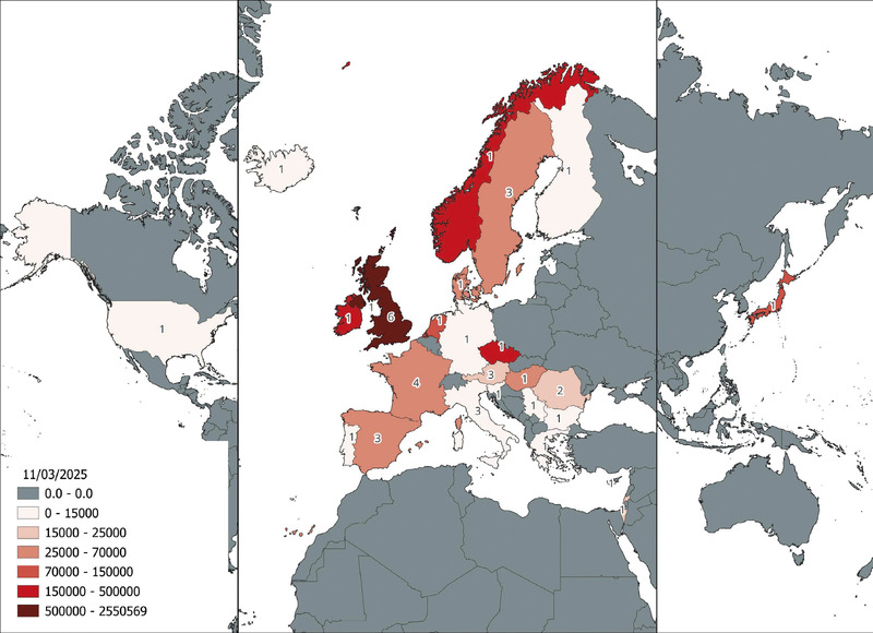
This article provides a preliminary analysis of the administrative metadata of the ARIADNE resources. ARIADNE, an acronym for Advanced Research Infrastructure for Archaeological Dataset Networking in Europe, is a European archaeological infrastructure that supports research. The presented analyses were performed accessing the ARIADNE Knowledge Base via its SPARQL Endpoint. The distribution of available resources per publishers’ country, of archival resources, of combinations of ARIADNE subjects and of combinations of agents (publishers, creators, contributors, owners, scientific responsibles) were estimated and commented, tracing an up-to-date profile of the infrastructure.
Thanks to the reconstruction of agro-pastoral land use of a territory, it is possible to obtain much information, both of an ecological nature, and about the populations. By the reconstruction of these dimensions of a community it is possible to understand not only the aspects linked to the exploitation of a territory, the subsistence and demography of a given group, but also more generally the group’s social organization itself. With a series of GIS tools, capable of applying the FAO’s land evaluation techniques, it has been possible to generate a predictive raster model of the landscape with the degree of agro-pastoral suitability inside each cell. Thanks to this model, the agro-pastoral exploitation of a territory can be simulated, calculating the food production of each settlement, as well as the consequent demography maximum sustainability. Thanks to the identification of specialized productions sites and of settlements capable of producing a ‘surplus’, or vice versa ‘not-self-sufficient’, it will be possible to articulate socio-political models, hypothesizing exchange networks or relationships between the different sites. The text illustrates in detail the structure and functioning of the developed model, as well as its applications in the archaeological context of the ‘Ager Tarquiniorum’ during the Final Bronze Age.
The Prairie Peninsula was a mosaic of tall-grass prairie and deciduous forest that existed historically in the midwestern United States (Transeau 1935). In
Archaeological site predictive modeling is widely adopted in archaeological research and cultural resource management. It is conducive to archaeological excavation and reveals the progress of human social civilization. Xiangyang City is the focus of this paper. We selected eight geographical variables as the influencing variables, which are elevation, slope, aspect, micro-landform, slope position, plan curvature, profile curvature, and distance from water. With them, we randomly obtained 260 non-site points at the ratio of 1:1 between site points and non-site points based on the 260 excavated archaeological sites and constructed a sample set of geospatial data and the archaeological based on logistic regression (LR). Using 10-fold cross-validation, we trained and tested the model to select the best samples. Thus, the quantitative relationship between the archaeological sites and geographical variables was established. As a result, the Area Under the Curve (AUC) of the LR model is 0.797 and its accuracy is 0.897 in the study. A geographical detector unveils that the three influencing variables of Distance from water, elevation and Plan Curvature top the chart. The archaeological under LR is highly stable and accurate. The geographical variables constitute crucial variables in the archaeological.
The Dutch consortium of university libraries and the National library of the Netherlands (UKB) together with the Association of Universities in the Netherlands (VSNU) and the Dutch Research Council (NWO), has published a practical guide on preprints. Preprints Preprints are [academic] manuscripts that have not been peer-reviewed or published in a traditional publishing venue. In Open Science and academic publishing, the preprint increasingly appears on the radar as an important element in academic communication. By posting preprints, academics can rapidly share their findings and build upon each other’s work. But, to what extent do they differ from articles published in an academic journal? How to post a preprint yourself and by, which preprint archive? How to interpret the research results published through preprints? About the guide The guide aims to support both researchers and members of the general public (journalists, patients, healthcare workers, etc.) from, but not limited to, the Netherlands answering these and other questions through sharply defined chapters and frequently asked questions.
Digital technologies are not neutral tools; rather, they mediate our knowledge of material evidence. This contribution stems from the reflections on the sidelines of the ArchAIDE project, which developed AI tools to recognise ceramics and attempts to answer questions, among others, on how technological intervention takes place in archaeology, particularly through AI, and if such effects are disruptive concerning epistemology and hermeneutics. Postphenomenology and material hermeneutics have been considered to describe the relationship between archaeology and digital technology. In the AI age, Archaeology’s challenge is to recognise technology as an actor (or maybe as an agent) on whom we depend on extracting meaning and, at the same time, as something that partially reflects our hermeneutic. The algorithms have digital technological intentionality that creates information, performs hermeneutics in our place, and finally directs archaeologists what to read. This act of knowledge is performed instead of ours. If, in Heidegger’s ontological inversion, science becomes dependent on technology and, in a sense, a tool of technology, in the same way, archaeology has become dependent on technology and entrapped by it.
Nowadays digital replicas of artefacts belonging to the Cultural Heritage (CH) are one of the most promising innovations for museums exhibitions, since they foster new forms of interaction with collections, at different scales. However, practical digitization is still a complex task dedicated to specialized operators. Due to these premises, this paper introduces a novel approach to support non-experts working in museums with robust, easy-to-use workflows based on low-cost widespread devices, aimed at the study, classification, preservation, communication and restoration of CH artefacts. The proposed methodology introduces an automated combination of acquisition, based on mobile equipment and visualization, based on Real-Time Rendering. After the description of devices used along the workflow, the paper focuses on image pre-processing and geometry processing techniques adopted to generate accurate 3D models from photographs. Assessment criteria for the developed process evaluation are illustrated. Tests of the methodology on some effective museum case studies are presented and discussed.
Offers a new approach to landscape perception.This book is an extended photographic essay about topographic features of the landscape. It integrates philosophical approaches to landscape perception with anthropological studies of the significance of the landscape in small-scale societies. This perspective is used to examine the relationship between prehistoric sites and their topographic settings. The author argues that the architecture of Neolithic stone tombs acts as a kind of camera lens focussing attention on landscape features such as rock outcrops, river valleys, mountain spurs in their immediate surroundings. These monuments played an active role in socializing the landscape and creating meaning in it.A Phenomenology of Landscape is unusual in that it links two types of publishing which have remained distinct in archaeology: books with atmospheric photographs of monuments with a minimum of text and no interpretation; and the academic text in which words provide a substitute for visual imagery. Attractively illustrated with many photographs and diagrams, it will appeal to anyone interested in prehistoric monuments and landscape as well as students and specialists in archaeology, anthropology and human geography.
The paper focuses on the work carried out in the insula 4-6 of Paestum (Italy), in the framework of a collaboration between the Archaeological Park of Paestum and the University of Naples “L’Orientale”; the contribution shows the “drone to BIM” solution applied for the study of the insula and the related methodological approach. The combination of the digital survey with the parametric reconstruction of the structures, which characterizes the so-called ABIM (Archaeological Building Information Modelling), provides a complete information system useful for different purposes, from documentation to interpretation and management. To systematize the incomplete archive documentation of the insula and to integrate the dwg file supplied by the Park, an aerial digital survey has been carried out to provide a detailed map of all the structures still visible on the area. The threedimensional information, derived from the UAV, constitutes the basis for the construction of the BIM model.
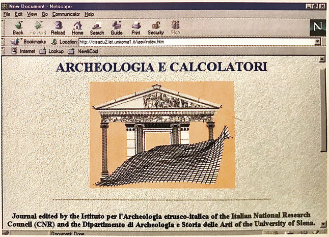
Over the course of 35 years since its foundation, the open access journal «Archeologia e Calcolatori» has been providing its publications online via the website, as well as open access metadata since 2005 through the OAI-PMH repository. In 2024, the website underwent a major update and restyling, including the addition of modern interoperability features, most notably the newly implemented JSON REST API. This paper is concerned with the technical description of the design and development of the new website and additional functionalities for «Archeologia e Calcolatori», while also giving a short overview of how the journal’s online presence has evolved over time. The exchange of data between the journal’s REST API and the Open Archaeology Hub (ArchaeoHub) currently being developed in the context of the H2IOSC project is described as well. Finally, some future perspectives for further improvement are presented.