Ancient South Arabian (ASA) is a conventional term to designate the languages which were spoken and written in South Arabia, the territory of present-day Yemen, between the early first millennium BCE and the late sixth century CE. Four languages are commonly subsumed under ASA: Sabaic, Minaic, Qatabanic and Hadramitic. These are named by modern scholarship after the political entities that are behind them. The four languages are quite different from a linguistic point of view. The four languages are unevenly distributed within the chronological framework of South Arabian history. First attestations of ASA textual evidence, written in Sabaic and Minaic and commonly dated to the ninth century BCE, occur in the Wadi al-Jawf in the north of Yemen. Linguistic affiliation of ASA has long been under dispute, oscillating between a classification as South Semitic (together with Ethiopic and Modern South Arabian) and as Central Semitic (with Canaanite, Aramaic and Arabic).
A stratified and complex investigation of the figurative language of a corpus of Mesopotamian glyptic artefacts will be described here. The methodologies adopted and the formal description of the products under investigation are the result of a
Lidar (a type of airborne laser scanning) provides a powerful technique for three-dimensional mapping of topographic features. It is proving to be a valuable tool in archaeology, particularly where the remains of structures may be hidden beneath forest canopies. Canuto et al. present lidar data covering more than 2000 square kilometers of lowland Guatemala, which encompasses ancient settlements of the Classic Maya civilization (see the Perspective by Ford and Horn). The data yielded population estimates, measures of agricultural intensification, and evidence of investment in landscape-transforming infrastructure. The findings indicate that this Lowland Maya society was a regionally interconnected network of densely populated and defended cities, which were sustained by an array of agricultural practices that optimized land productivity and the interactions between rural and urban communities.
The paper presents an integrated and multidisciplinary study of the territory through the combination of geomorphological, historical and topographical data, with the aim to underline the most relevant changes occurred in the landscape of the northern Marche (Italy) during the Late Holocene (between the Roman and Middle Ages). In particular, the attention is focused on the transformations occurred in the Cesano River valley, through the analysis of the reciprocal influences between human presence and physical geography. A specific attention is reserved to the watercourses and bed configu-ration changes in relation to the territorial organization, also considering the climatic fluctuations attested after the Roman period.
This is the first collection of pictures of almost all the ancient theatres, odeons, bouleuterions, stadiums, and amphitheatres in existence. Sure to give enjoyment to the armchair traveler, this clothbound volume is also an essential reference for all those interested in ancient architecture.The purpose of this book is to tempt similar-minded others with a passionate bent toward Hellenistic and Roman theatres and amphitheatres (and temples, aqueducts, bridges, and triumphal arches) to drive the borders of the Mediterranean and revel in and marvel at these ancient glories. It was the pleasure of the drive through these beautiful and generally hospitable countries almost as much as the "discovery" of ruins that beguiled the author and his wife to compile the collection.
The thesis aims to investigate pottery production in the rural taskscapes of the Classical and Hellenistic Greek world, focusing on how the environmental and socio-economic settings influenced the locational choices of the kiln sites in the landscape. It also aims to explore the spatial and seasonal connections of pottery making with other economic activities and how these connections create a taskscape for humans living and working in the Greek countryside. The analysis focuses on three regions of the ancient Greek world: the chora of Metaponto in Basilicata, southern Italy; the Berbati Valley in Argolid, Peloponnese; the island of Thasos, northern Aegean. They have different geomorphological and topographical settings to explore the location and affordability of resources for pottery production in different natural settings and the influence on the decision-making of the people involved in pottery production and other tasks. For each regional case study, the geomorphology and palaeoenvironment are studied to assess the availability of resources and reconstruct the vegetation landscape and the agrarian economic activities. In addition, pottery production sites are examined to determine kiln technology, the scale of production and the type of ceramic products. The application of a GIS-based approach with spatial analysis methods enables us to understand the social dimension of landscape. The Cost Distance and Least-Cost Path analysis is integrated with the calculations of labour costs for the transportation of raw materials and provides further information on the effort of movement in the land; it also assesses the temporality of the pottery manufacturing-related tasks and its combination with the seasonality of the agricultural works. The Least-Cost Path also reveals the links between pottery production sites and rural sites in the territory, and the importance of the communication networks for the movement of people, resources and ceramic products. The thesis demonstrates that the rural Greek world was not only centred on the agrarian economy but it was a more holistic world, where people were engaged in different activities tightly entangled with each other. Pottery production in the rural countryside was usually a small-scale activity focused on local distribution for everyday life. Indeed, utilitarian wares, roof tiles, and votive terracottas for rural sanctuaries were produced. The organisation of the workshop space and the energetics of the logistics of pottery production suggest that labour in the small rural workshops was part-time and not specialised, and workshop facilities could be shared by multiple part-time potters. However, there were also some large-scale production sites, such as Pantanello, where the large kilns, the organisation of the workshop, and the energy calculations suggest the employment of full-time labour, with an additional part-time workforce for the busiest firing months. Nevertheless, the ceramic products are still aimed for local distribution. The exception is the workshops of Thasos that produced amphorae part of which were stamped and aimed for overseas export. Finally, the spatial analysis approach demonstrated that the location of pottery production sites was entangled with the accessibility to raw materials, such as clay and fuel, and the presence of roads and pathways.
Ancient Greece was permeated by music, and the literature teems with musical allusions. Here at last is a clear, comprehensive, and authoritative account that presupposes no special knowledge of music. Topics covered include the place of music in Greek life, instruments, rhythm, tempo, modes and scales, melodic construction, form, ancient theory and notation, and historical development. Thirty surviving examples of Greek music are presented in modern transcription with analysis, and the book is fully illustrated. Besides being considered on its own terms, Greek music is here further illuminated by being considered in ethnological perspective, and a brief Epilogue sets it in its place in a border zone between Afro-Asiatic and European culture. The book will be of value both to classicists and historians of music.
From late fourth century BC Seleucid enclave to capital of the Roman east, Antioch on the Orontes was one of the greatest cities of antiquity and served as a hinge between east and west. This book draws on a century of archaeological fieldwork to offer a new narrative of Antioch's origins and growth, as well as its resilience, civic pride, and economic opportunism. Situating the urban nucleus in the context of the rural landscape, this book integrates hitherto divorced cultural basins, including the Amuq Valley and the Massif Calcaire. It also brings into focus the archaeological data, thus proposing a concrete interpretative framework that, grounded in the monuments of Antioch, enables the reader to move beyond text-based reconstructions of the city's history. Finally, it considers the interaction between the environment and the people of the city who shaped this region and forged a distinct identity within the broader Greco-Roman world.
The article emphasizes the importance of anatomical-morphological analysis of a volume 3D model reconstructed from microcomputer tomographic 2D images for archaeological documentation and treatment, non-invasive archaeological analysis, and a more optimal selection of conservation methods and techniques. The object of μCT reconstruction is a 40,000-year-old Palaeolithic hunting weapon found in 2008 in the Ljubljanica River near Sinja Gorica (Vrhnika, lat.: Nauportus, Slovenia). This wooden point (yew; lat.: Taxus baccata) is so far just one of only eight known Palaeolithic wooden artifacts found in Europe. Between 2013 and 2017, the point was conserved using a traditional waterlogged wood processing technique with melamine resin. Using computer volumetric analysis of five surface 3D models, taken before, during and after the conservation, it was found out that volumetric changes and deviations of the point have occurred (bending, weight, volume, surface cracks and changes). Surface changes of the 3D models did not answer the question: what are the causes for the resulting changes after the conservation process? Only anatomical-morphological analysis of the internal structure of the point could answer this question. To this end, we developed an iterative segmentation algorithm adapted to archaeological analysis for the reconstruction of a volume 3D model from microtomographic 2D images. In this way, we successfully supplemented the data of the surface 3D model and confirmed volumetrically and graphically the current and critical state of the internal anatomical structure of the artifact (cracks, fractures, etc.). The case study confirmed the exceptional importance of the use of microcomputed tomography as a non-invasive technique in archaeological analysis and in the planning and selection of procedures for conservation, restoration and storage of sensitive archaeological heritage remains in situ or ex situ.
This article examines Anatolian–Transcaucasian interactions spanning the Chalcolithic through the Bronze Age. The five millennia surveyed here have highlighted some broad patterns of cultural interaction. At present, evidence suggests that farming was introduced to the Transcaucasus. It appears fully fledged in the late seventh millennium BCE, together with compounds of round houses built for the most part with plano-convex bricks. The degree of interplay with surrounding regions cannot be ascertained, but it does appear that in these formative centuries Transcaucasian communities remained isolated and developed their own distinctive cultural identity. Attitudes changed in the Late Neolithic when Halaf networks made inroads into the mountains of southern Transcaucasia, probably to exploit the rich sources of obsidian. The tempo of communication accelerated during the Late Chalcolithic period.
Two perspectives on cartography are drawn together by examining virtual map use in spatial-analytical systems: the "map as a presentation image" and the "map as a computational tool." Map use is characterized in terms of three levels of tasks and two types of information products commonly generated. Level-one tasks include distinguishing individual symbol differences, the most basic information on a map. Level-two tasks include identifying clusters of symbols. Individual symbols and clusters of symbols constitute surface-structure information on a map. Level three, the primary focus of this article, includes decision-making and content-knowledge-building activity for geographical problem solving. Such tasks emphasize the use of deep-structure information on maps. Deep-structure information, also called conceptual information, primarily consists of geographical relationships as part of spatial context and meaning. Both surface and deep structure compose an information structure. An information structure is important in providing a context for query-mode and product-mode information products primarily at level three. Spatial data models capable of storing and/or deriving information structures are discussed using a spatial-analysis perspective. More flexible data models are required to store and manipulate geographic data semantics if level-three tasks are to be addressed. Such data models can form the basis of social-science geographic information systems (GIS).
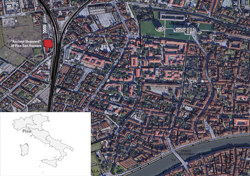
This paper aims to present analytical approaches and digital methods for the analysis of ceramic assemblages resulting from catastrophic alluvial flood flows. The study has been developed based on the principles of ‘alluvial archaeology’, a recently-developed field of archaeology. In this research program, ceramic records have been treated on a par with clasts in the geomorphological analyses of alluvial sediments. To test the different analytical procedures the ‘Ancient Shipyard’ of Pisa-San Rossore has been selected as a case study. This archaeological site represents a river channel, affected by several alluvial flood events. The analysis achieved several objectives, including the definition of the formation processes of the deposition (in synergy with the results of geomorphological data), the chronological framework of alluvial floods, the dynamics of flows, and locating the original deposition of the ceramic assemblage. In this regard, the combination of different approaches has proven particularly useful, ranging from computational analyses for chrono-typological determination of ceramic assemblages to intra-site spatial analyses, which have been useful in defining alluvial flood flows and the subsequent movement of ceramic assemblages.
This chapter presents the potential of interoperability and standardised data publication for cultural heritage resources, with a focus on community-driven approaches and web standards for usability. The Linked Open Usable Data (LOUD) design principles, which rely on JSON-LD as lingua franca, serve as the foundation. We begin by exploring the significant advances made by the International Image Interoperability Framework (IIIF) in promoting interoperability for image-based resources. The principles and practices of IIIF have paved the way for Linked Art, which expands the use of linked data by demonstrating how it can easily facilitate the integration and sharing of semantic cultural heritage data across portals and institutions. To provide a practical demonstration of the concepts discussed, the chapter highlights the implementation of LUX, the Yale Collections Discovery platform. LUX serves as a compelling case study for the use of linked data at scale, demonstrating the real-world application of automated enrichment in the cultural heritage domain. Rooted in empirical study, the analysis presented in this chapter delves into the broader context of community practices and semantic interoperability. By examining the collaborative efforts and integration of diverse cultural heritage resources, the research sheds light on the potential benefits and challenges associated with LOUD.
'Which test should I apply?' During the many years of working with ecologists, biologists and other environmental scientists, this is probably the question that the authors of this book hear the most often. The answer is always the same and along the lines of 'What are your underlying questions?', 'What do you want to show?'. The answers to these questions provide the starting point for a detailed discussion on the ecological background and purpose of the study. This then gives the basis for deciding on the most appropriate analytical approach. Therefore, a better start
This paper outlines research towards strengthening our understanding of the representation of cultural artifacts in video games. The approach described outlines steps towards utilising a framework using dimensions of cultural heritage as reference points for games analysis. This framework is then used as a mechanism to analyse two games: Assassin’s Creed I and Unearthed: Trail of Ibn Battuta. The case study analysis presents concerns regarding cultural representation in the selected games. This is followed by a discussion of the main concerns coming out of the analysis. These concerns are effectively grouped under five sections: ‘cultural appropriation’; ‘hollywoodisation and beautification’; ‘selectivity’; ‘game dynamics rule design decision’; and ‘ideological constraints’. The research raises issues about how video game designers approach the inclusion of items with cultural meaning in their products. Next stages in the work involve interviewing of games designers to better understand how the design decisions presented in this paper occur.
A methodology for the statistical estimation of the tumular dimension of simple megalithic monuments is developed through Simple Regression Analysis. Such a perspective may contribute to the global comprehension of badly preserved megalithic monuments and to establishing their role in the landscape; at the same time, and under certain circumstances, the statistical estimation can help in the planning of archaeological activities involving the monuments.
A new approach to the topic of Late Bronze-First Iron Age settlement patterns in the south-eastern countryside around Seville (Andalusia, Spain) is presented by the application of a new landscape analysis technique: visibility analysis. Some aspects of visibility analysis are discussed, as well as the resulting methodological proposals. Finally, this methodology is applied to the study area, generating historical interpretations about related questions (settlement patterns, means of communication).
Building Information Models (BIM) are presented as a tool with interesting possibilities in the fields of knowledge, management and dissemination of architectural and archaeological Cultural Heritage. This study describes the work process and the results of the development of such a digital model for the extra-urban sanctuary of the city of Tusculum, one of the best-preserved buildings of the site, yet less known and studied. Within the framework of a new phase of research on the archaeological site, the stratigraphic and constructive analysis of the wall that delimited the original terrace of the complex has been carried out. This has allowed to determine a chronological sequence and to establish the bases for the modelling of both the current state and some of its evolution phases, thus enabling a proposal for restitution of some of the previous states of the complex. The aim was to build a model that synthesizes the current knowledge and that has open and flexible characteristics, so that future research can enhance, complement or correct it.
The territory of Sarcidano is very important for the study of the settlements of the Nuragic population in the central-southern Sardinia (Italy), as the archaeological evidence of the late phases of Bronze Age and Early Iron Age shows. In particular, the great sanctuary of Santa Vittoria at Serri stands out on the homonymous plateau and exercises a control of the surrounding territory, corresponding in whole or part to the territories of the Serri, Escolca, Gergei, Isili, and Nurri municipalities. In this work, we experimented with an analytical procedure not yet widely used in the study of settlement processes in the Bronze and Iron Ages: that of Spatial Autocorrelation Techniques. The advantage of this approach lies in the fact that it not only shows spatial relationships, but does so on the basis of different values connected to the spatial data. Results showed that the Nuragic monuments were built near routes of passage so as to control the valleys below the basalt plains. This demonstrates the existence of a specific and organized approach for exploiting and monitoring the landscape, in which settlement choices depend on functionality criteria, with both nuraghi and villages having a key role on the strategic control of the territory.
The analysis of the spatial distribution of archaeological records combined with geo- statistical techniques plays a primary role in the field of prehistoric archaeology because this methodological approach can be used to understand if a real or
This project was established through a collaboration between the Missione Archeologica Italiana in Turchia (Università di Roma “La Sapienza”) and the Istituto per le Tecnologie applicate ai Beni Culturali of the CNR. For this project we selected over 700 ceramic samples found at Arslantepe, coming from structures and layers of IV and III millennium BC The samples were chosen in order to obtain a complete picture of the typological classes coming from the different chronological phases. The use of the ceramic classes and their related structures were also investigated, using traditional archaeometric analyses. Taking into consideration such a large time scale, the aim was to study the socio-cultural and economic development and transformations showed by the technology of ceramic production. The management of such a large amount of data, and the high number of interrelationships, required the use of a computer-based system. Statistical analyses were conducted using the software SPSS, specialised for Social Sciences applications.
This article presents the first results of a statistical analysis applied to the ceramic artifacts from the Late Bronze Age settlement of Sorgenti della Nova (Farnese, Viterbo). After organising the data in a logical structure of relationships, with the setting up of a classification code and automatic processing, various methods of descriptive and multivaried analysis were applied (Frequency Analysis, Crosstabulation, Cluster Analysis). The main objective was the reconstruction of as great a number of shapes from fragments as possible, consequently observing the distribution dynamics of these within the site. The analysis enabled us to increase the possibility of recognising the ceramic forms by roughly 25%. It allowed us also to observe how, even within a situation of substantial uniformity in the site, a distinct separation emerges in certain structures, including, among other factors, the material culture, such as for example, the oval huts with foundations on channels, the grotto-sanctuary 7 and the monumental structure in sector Vb.
This paper considers certain geometrical aspects of three Late Roman oil lamps. Comparison is performed by choosing amongst the geometric indexes in order to single out and estimate similarities and peculiarities of their shape. The preferred indexes chosen were symmetry and a particular size ratio. A difficulty arose from the fact that, since one does not know the numerical variability of the indexes depending on even small deformations, poor information can be obtained. Therefore, using bootstrap resampling the sample distribution is estimated for the two indexes. Through its application, one can build new methods of comparison in order to evaluate similarities and differences otherwise impossible to evidence using conventional methods.
Knowledge is an essential operating procedure in any project involving direct intervention in historic buildings. Reading the stratification of natural and anthropic events on the architecture, providing the careful evaluation of its historical-constructive complexity, is a crucial step towards a full knowledge of the formal and physical characteristics of the building under analysis. The contribution, starting from the revision of the sheets used for documenting historical buildings in areas at seismic risk within the Ministry project of the ‘Atlante dei Tipi Costruttivi Murari d’Italia’, aims to illustrate, by means of a distinctive case study, that of the Pieve di Sant’Agata, how the contribution of modern surveying technology has significantly improved the recording of archaeo-seismological data both qualitatively and quantitatively. This information, once interpreted, provides a full historical, constructive and seismic understanding of the architectures, helping the process of historical knowledge of the context under study and, at the same time, the documentation, evaluation and planning of the restoration work.
Negli ultimi 160 anni il paesaggio alpino legato allo sfruttamento stagionale delle alte quote ha subito profondi cambiamenti. Questo articolo presenta le ricerche condotte nel territorio di Brentonico (TN) che hanno documentato un periodo di
This paper analyses a new form of environmental visibility of ancient highland sites in Abruzzo (Central Italy) during arcaic period. This investigation offers unique opportunities for understanding the management of economic and political spaces of pre-Roman populations (i.e., Peligni). Through spatial analyses, the sites of valle Peligna are classified into different types. Then, they are contextualised within the historical and archaeological landscape. The results offer new clues for identifying a nonurban state system, which is well known in ancient literature but has yet to be traced in archaeological reconstructive models.
Relationships between communities who inhabited the Fiora river basin during the Bronze Age and surrounding landscape have been examined to give more insight into the choice of settlement location, on the basis of landscape analysis methods adopted in environmental studies. By processing Landsat TM and elevation (raster) data and water related (vector) data (all georeferenced to a UTM grid), respectively spectral (the six TM band values), morphometric (elevation, aspect and slope etc.) and hydrological (distance to water from a site etc.) parameters have been derived for about 50 settlements detected in the study area. These parameters have been statistically analysed by separately processing the spectral, morphometric and morpho-hydrological values using a hierarchical cluster analysis method. The spectral data classification has yielded, with two exceptions, two main groups, one characterised by intermediate reflectivity, medium-low vegetation percentage and variable moisture; the other, more defined, with mostly dark and very humid soils, includes also 32% of the Final Bronze settlements. The classification of the morphometric parameters has highlighted elevation as the discriminating variable, obtaining two main clusters: the first includes sites located above 400 m; the second splits into two subclusters, one with sites between 50 and 200 m, the other between 200 and 400 m. Among the subclasses, three exhibit sites belonging to the Final Bronze Age, one includes sites of the Early Bronze Age. Therefore, the classification of the morpho-hydrological parameters shows that both elevation and water distance appear discriminating. The highest values of these two variables characterise a single site, clearly separated after cluster analysis application, which again yielded three subgroups belonging to the Final Bronze Age.
Fabric analysis in archaeology is the study of the spatial arrangement of a deposit through measurement of bearing and plunge angles of its singular components (natural and/or artificial) and through analysis of their mutual spatial relations and with the external environment. In recent years some archeologists (Lenoble, Bertran, McPherron, etc.) have developed a standard procedure for angular data collection and for statistical treatment of this information. The author proposes some conceptual and methodological innovations to improve this method: the application of fabric analysis to any historical and depositional context (in particular, anthropic contexts); the use of "ab plane" (instead of "a axis") for measurement of bearing and plunge of clasts; the development of spatial analyses associated with traditional statistical treatments; the management of data through geodatabase and GIS directly connected to the statistical software. In the future, this method will need other improvements in order to provide more information about origins, causes, and dynamics that produced a specific deposit from fabric analyses.
The huge amount of available records belonging to the Italian Bronze Age and the necessity to find a methodological support in data treatment prompted the research group of the University of Bologna to build and test IT solutions. In particular, material culture data were processed within a database system, in order to develop a typological classification, linked to the table containing provenance data (site and context) and to a GIS. Therefore, through the geostatistical analysis it is possible to visualize and easily evaluate the distribution of each type or of any other result. The system includes a visualization module of cumulative graphic documentation resulting from queries to the database for a better reconnaissance and validation of the typological classification. Final aim of the project is the possibility to share with other scholars and institutions any record or any result of distributional analysis through a webGIS, now available in a preliminary testing form.
The area of Northern Israel has been a region of interest for archaeologists. Textual materials are various and useful to reconstruct the history of the region, as well as a lot of data coming from the material culture. This way, archaeologists may shed light on the complex framework of cultures that developed in this territory. In the period between the 1st century BCE and the 2nd century CE, the growing influence of the Romans generated a substantial integration of Galilee into a global context. Through the application of new types of analysis, it is possible to reconstruct cultural and commercial trades of the area. The application of network analysis to archaeological questions is a pivotal subject of scientific debate. In this work, we aim to reconstruct the dynamic connections between Jewish settlements in Galilee on the basis of consistent evidence, speculating on the presence of links whenever proof lacks. Data referring to many types of artefacts were derived from the analysis of scientific papers and archaeological excavation catalogues. This way we obtained a multiplex network in which the nodes are the sites and the links are given by the presence of the different artefacts. Here we present the first findings from an exploratory analysis. Visualization methods are exploited, such as multi-force embedding and multi-task network embedding algorithm. More specifically, the latter, which is based on link prediction, seems to be particularly suited for the data we are dealing with, in which the absence of a link could be due to missing data. Moreover, in order to consider how connections have changed over the reference period, a temporal approach is used. Multiplex network analysis can also be used to model dynamic networks where each layer corresponds to the network state at a given moment.
In this paper a comparison between data on African Red Slip from several Italian and African sites is attempted. The aim of this preliminary survey is the detection of variations in the distribution and use of this ceramic production in the 5th century AD. At the same time the patterns of trade, and the differences between the diffusion in African sites, the overseas distribution and the local markets, are examined. Those differences can be detected by means of comparative analysis between contexts coming from different kinds of settlements: major centres, ports or more or less isolated sites. The presence of the various productions and forms of ARS have been compared with multivariate statistical analyses.
The aim of this paper is to provide an update to the debate concerning the production technology of bucchero pottery, as well as presenting new data on the use of raw material for its manufacture and the temperatures of firing. This interdisciplinary research focused on a period of technological changes in bucchero production during the sixth century BC, by applying a quantitative analytical approach using X-Ray powder Diffraction (XRD), X-Ray Fluorescence (XRF), Thermogravimetric Analysis and Differential Thermal Analysis (TG-DTG), and multivariate statistical analyses. A series of samples from northern Etruria (mainly the area of Volsinii) were compared with products from Veii, Ardea, Segni and Pompeii. XRF and XRD analyses provided quantitative results, statistically analysed, concerning the use of raw material, both calcareous and non-calcareous, and the technology of firing where temperatures reached 950°C or above. TG analysis proved that the black surface of bucchero was due to reduced iron oxides and the presence of carbonaceous material on the surface. However, XRD results demonstrated that firing occurred at a high temperature and the ratio between aluminium and iron in the samples led to the formation of hercynite, an iron-aluminate spinel. The results of the study show that during the sixth century BC the changes in technology to obtain a quality bucchero production were related to a sufficiently long soaking period at a high temperature in a reduced atmosphere, regardless of the presence of calcite in the source material.
The data gathered during the excavation of the cemeteries of the Etruscan-campanian settlement of Pontecagnano (Salerno, Italy) has been stored in a GIS implemented using Mapinfo. In the paper we are going to present an interface developed in Mapbasic language (Mapinfo environment) for the analysis of the funerary contests. Through this solution, it is possible to manage some thematic maps (diachronic, typological, anthropological, etc.), to make interactive queries of the graves and of their grave-goods. Using a simple forms it is possible to visualize the spatial distribution of the tombs starting from topologic criteria. The results obtained with our utility can be viewed immediately on the map, also crossing data with different criteria. This permits to analyze not only the archaeological evidence digitized on the map, but also to explore and visualize multiple information stored in the graphic and alphanumeric archives.
Although there have been numerous studies of individual cities or groups of cities, there has never been a study of the urbanism of the Roman world as a whole, meaning that we have been poorly informed not only about the number of cities and how they were distributed and changed over time, but also about their sizes and populations, monumentality, and civic status. This book provides a new account of the urbanism of the Roman world between 100 BC and AD 300. To do so, it draws on a combination of textual sources and archaeological material to provide a new catalogue of cities, calculates new estimates of their areas and uses a range of population densities to estimate their populations, and brings together available information about their monumentality and civic status for the first time. This evidence demonstrates that, although there were relatively few cities, many had considerable sizes and populations, substantial amounts of monumentality, and held various kinds of civic status. This indicates that there was significant economic growth in this period, including both extensive and intensive economic growth, which resulted from an influx of wealth through conquest and the intrinsic changes that came with Roman rule (including the expansion of urbanism). This evidence also suggests that there was a system that was characterized by areas of intense urban demand, which was met through an efficient system for the extraction of necessity and luxury goods from immediate hinterlands and an effective system for bringing these items from further afield. The disruption of these links seems to have put this system under considerable strain towards the end of this period and may have been sufficient to cause its ultimate collapse. This appears to have been in marked contrast to the medieval and early modern periods, when urbanism was more able to respond to changes in supply and demand.
Since 2017, a new research project has been undertaken by the University of Bologna on Urban Archeology in Rimini, as part of an agreement with the Soprintendenza Archeologia, Belle Arti e Paesaggio per le Province di Ravenna, Forlì-Cesena e Rimini. This project is an integrated study with academic aims that hopes to produce a map of the archeological evidence of the city. In the first phase of work, which is still ongoing, the researchers have been focused on the architectonic study of some important monuments of the Roman city which are still part of the current urban landscape, such as the Theater, the Amphitheater, Tiberius’s Bridge and the so-called Arch of Augustus.
Over the years Correspondence Analysis has become a valuable tool for archaeologists because it enables them to explore patterns of associations in large contingency tables. While commercial statistical programs provide the facility to perform Correspondence Analysis, a number of packages are available for the free R statistical environment. Nonetheless, its command-line structure may be intimidating for users and prevent them from considering the technique. This article describes an R script, written by the author, which aims to free the R user from manually entering long pieces of code. By discussing two worked examples, it shows how the script can provide the user with a body of graphical and textual outputs relevant to the interpretation of data structure. It is hoped that the script will allow the user to concentrate more on the analysis results rather than the syntax of the R environment.
Moudgil, AditiSingh, SaravjeetGautam, VinayOCR systems capable of recognizing characters have gained maximum concentration of researchers these days, especially when it comes to recognizing ancient documents. Digitization of these documents to make them readable and also searching from paper-based data becomes a great challenge. Literature shows that there are a lot of OCR systems that use different feature extraction and segmentation techniques to calculate the recognition accuracy. This paper focuses on a variety of classifiers and feature extraction techniques used to segment characters individually to make them readable by machines. The purpose of recognition of these documents is to preserve the heritage and valuable information contained in ancient manuscripts written in different languages.
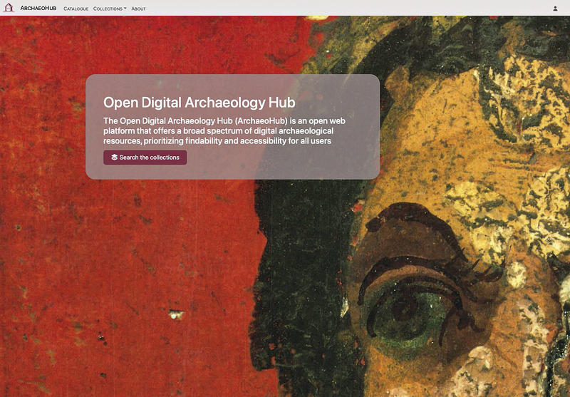
The Open Digital Archaeology Hub (ArchaeoHub) is a modular and extensible platform developed within the H2IOSC project to support the aggregation and dissemination of digital archaeological resources. Conceived as a metadata aggregator rather than a repository, it integrates textual, visual, and bibliographic data from diverse sources, including the journal «Archeologia e Calcolatori» the BiDiAr bibliographic platform, and the DHeLO web app. Its structure is based on a hub-and-spoke model, designed to enable thematic collections organised around geographic entities, using Pleiades identifiers and WebGIS technologies to enhance discovery and contextualization. ArchaeoHub promotes interoperability through standards such as RDF, Dublin Core, and JSON-LD, and supports linked data connections with external resources. It offers scholars and institutions a lightweight, FAIR-compliant environment to access and cross-reference data. A key feature is its integration with BiDiAr, a curated bibliography of digital archaeology structured through Zotero, enabling citation tracking and semantic classification. The platform exemplifies a shift from static repositories to dynamic, research-oriented infrastructures aligned with national and international best practices. Positioned within the broader landscape of digital heritage infrastructures, ArchaeoHub serves as both a scholarly resource and a methodological prototype for managing complex00 archaeological information in a collaborative, open-access framework.
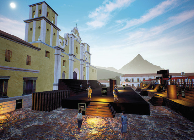
Virtual Reality is one of the tools that has become widely used in recent years, in the field of cultural heritage. This tool has proven to be particularly valuable, especially for approaching intangible cultural heritage. Using free and open source software for 3D modeling and animation, such as Blender and Unreal Engine, the international research group, Praeteritas Urbes, focused on the reconstruction of historical events such as the inquisitions many Autos de Fe, which had a significant impact on the colonial history of Central America. In this paper, we will present the results of two different projects: ‘The Great Auto de Fe of Guatemala’, which took place in Santiago de Guatemala in 1554, and ‘The Auto de Fe of Maní’ (Yucatán, Mexico), which occurred in 1562. In both cases, our objective was to make simulations of these two events known and accessible to the public, using a precise methodology, following the scale of evidence, and adhering to the standards established in the Principles of Seville codified in 2017.
Digital representation and organization of legacy data plays a crucial role in the diffusion, use, and understanding of data stored in old publications, archives, and museums. An interesting case study comes from data of potteries discovered in ancient rural territories of Eastern Sicily, as the majority of legacy data for this research area exists in the form of old maps and paper catalogues: to make these datasets available at a global level, innovative digital technologies are needed.