Our paper intends to provide an overview of archaeological open access journals, with particular reference to Italy, starting from the experience of «Archeologia e Calcolatori». Alongside published journals, on-line open access journals are
Recent changes to the availability and accessibility of LiDAR data in Italy have greatly expanded the potential for their exploration by members of the general public. Further promotion of this fact and how to engage with such data could prove to be of significant value to both archaeologists and other interested parties.
The Torre Spaccata valley, situated in the southeastern suburbs of Rome, was investigated between 1997 and 1998 and again in 2006. It lies about 15 km from the Colli Albani volcanic complex, the recent evolution of which incorporates deposition of the volcanic-sedimentary sequence of the Tavolato Formation (including the Albano lahar deposits). During the excavations, a limited strip of lahar was uncovered and dated archaeologically to the fourth century BCE. Other main features include several intercrossing channels with a sandy-pebbly fill, evidence of intermittent hydrological activity. In this area there is evidence of a prolonged interaction through time between human activity and the valley’s varying environments. The prehistoric evidence (third to second millennium BCE) is well documented in a concentration of sites on the eastern outskirts of Rome. The prehistoric evidence (third to second millennium BCE) has a good context in the concentration of sites in the eastern outskirts of Rome. Other reliable traces date to the fourth to third century BCE, soon after local lahar deposition. During the Late Republican and Imperial period, the hilltops were occupied by a dense system of villae. Later remains provide evidence for agricultural use of the valley floor during the Middle Ages.
This paper begins with four propositions: there are four basic types of information: data (or more precisely numbers), text (i.e. single words, sentences and longer compositions), images (still and moving), and sound; that computer technology has now advanced sufficiently in power to capture, store, manipulate and retrieve all the types of data listed in the first proposition; that archaeological information is composed of all five types of information outlined in the first proposition; and that since archaeology also has vast quantities of this information it needs computer technology in order to handle it successfully. Given these propositions, this paper describes the purpose of the Ashmolean Museum of Art and Archaeology and defines three separate roles that result. The historical development of IT applications since the late 1970s is traced, highlighting the mistakes made and the lessons learnt. This culminates in a description of the Ashmolean’s Collections Information System, in particular outlining the structure of the Collections Information Database that underpins the system. The plans for implementing this system are also described. The paper ends by looking at the problems of fully realising this system, and concludes that the plans are really a means of deliberately staying several steps behind the full potential of the technology while still moving forward, so that the Museum can wait for the eventual arrival of software that can provide a seamless transition between various tasks, with a minimum of effort.
A museum on paperA recent colloquium on French archaeology in the second half of the 19th century drew attention to the work of a talented illustrator, Victor Caucheiné, several of whose watercolours may be seen at the niuseuni in Compiègne. Additional research, intended to place this painterarchaeologist in historical context, showed that his situation was not unique and that, during the same period, in France well as elsewhere in Europe, there was a surge of interest in reproductions of objects and of archaeological sites. This is not to be confused with the fashion for romantic landscapes, of which Baron Taylor's Voyuges dons l'ancienne France serves as a good example (Adhémar 1997), nor with the passion for monuments, as shown by the imposing collection of Laborde (Laborde 1816-1836). Rather, this activity was the doing of an archaeological school which, for three-quarters of a century, set out to explore the meaning of archaeological excavation and their associated finds.
Out now in the August issue of the Journal of Archaeological Science is: Archaeological GIS Today: Persistent Challenges, Pushing Old Boundaries, and Exploring New Horizons Edited by Meghan C.L. Howey and Marieka Brouwer Burg
The paper discusses new trends in the archaeological documentation practice, heavily conditioned by the capillary diffusion of web-based technologies and cloud-based services. In this context, a close examination of BraDypUS, a libre and open source project both available for download, self-hosting and as a cloud service, is presented. The online availability of archaeological data sets and the possibility of building new original research on them, by adapting original schemas and formats to new requirements, is considered a very promising initial step towards a more collaborative research. Reducing IT barriers and setting the stage for web-based data management and publication to small-scale (single-researcher and/or highly specialized) projects, will lead to a new era for archaeological data analysis and dissemination.
This dissertation critically examines the sociotechnical structures that archaeologists rely on to coordinate their research and manage their data. I frame data as discursive media that communicate archaeological encounters, which enable archaeologists to form productive collaboration relationships. All archaeological activities involve data work, as archaeologists simultaneously account for the decisions and circumstances that framed the information they rely on to perform their own practices, while anticipating how their information outputs will be used by others in the future. All archaeological activities are therefore loci of practical epistemic convergence, where meanings are negotiated in relation to communally-held objectives. Through observations of and interviews with archaeologists at work, and analysis of the documents they produce, I articulate how data sharing relates distributed work experiences as part of a continuum of practice. I highlight the assumptions and value regimes that underlie the social and technical structures that support productive archaeological work, and draw attention to the inseparable relationship between the management of labour and data. I also relate this discursive view of data sharing to the open data movement, and suggest that it is necessary to develop new collaborative commitments pertaining to data publication and reuse that are more in line with disciplinary norms, expectations, and value regimes.
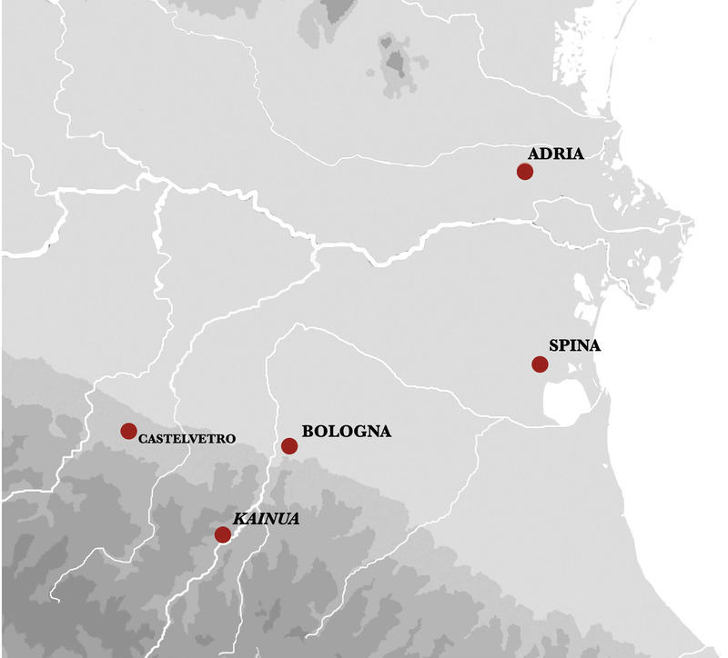
This contribution deals with the use of relational databases (RDB) and GIS for the spatial analysis of Iron Age funerary contexts in the Italian peninsula through two projects by the Chair of Etruscology at the University of Bologna. The two selected case studies of Bologna’s western necropolis and Spina’s Valle Trebba necropolis represent distinct phases of research and discuss the challenges in updating historic systems and creating dialogue between systems adopted at different times. The Bologna case provides the opportunity to discuss the quality of data from old excavations in reconstructing funerary landscapes using GIS. The case of Valle Trebba exemplifies the difficulties in planning and managing information on 1215 tombs and over twelve thousand objects through an articulated relational archiving system. The iconography of Attic pottery allows us to understand the management of qualitative data. As far as spatial analysis in a GIS environment is concerned, we reassessed the solutions adopted for the Valle Trebba project, which are currently unsatisfactory, as they do not meet the principles of accessibility of such tools, nor Open Data Standards.
This paper is a brief and personal historical overview of the development of archaeological computing and its relationship with changing archaeological theory. I outline the changes in theoretical approaches through the 1960s to 1980s and how these relate to archaeological data, methodologies, the use of models and interpretation. Two sub-themes within the paper are the importance of scale and the representation of qualitative, as well as quantitative, data and interpretations. Through the use of Geographic Information Systems (GIS) applications in archaeology, I discuss various aspects of recent theoretical approaches and how they have been represented through archaeological computing. Because this is not an easy relationship, I suggest that the intentions of an analysis will inevitably produce tensions between practice and theory. It is by confronting these tensions that the discipline of archaeological computing will move forward beyond technologically determined push-button solutions.
Visual information is not only a source for multimedia applications. Every mapped but also represents a location in 3D space. So any bit-mapped visualisation of a surface also represents the 3D hull of an object. Therefore visual information is a source to rescore the shape of physical solids from their "envelopping" closed surfaces, and serves as the information needed to reconstruct buildings and their related artefacts. In respect of 3D surface measurement, a "virtual reality" is understood as a virtual solid in its original size to be measured and analysed. These measurable world object simulations represent the information of form to shape three-dimensional things. These are not brought to physical existence, but represent measurable solids to analyse statistically controlled properties with their related and following functions. From the photograph of a broken amphora the body is completed to calculate its weight and volume and even the fitting shape of the boat to transport a load. Of course the same model of extrapolation applied to buildings will not focus the statics of buildings but the environmental building physics and its following functions.
The widespread use of technologies and processes aimed at information management is one of the main trends in today’s building industry. Collaboration, coordination and validation of design results are fostered by software and workflows that involve many disciplines. Taking into account these premises, this paper deals with the application of such a paradigm to the archaeological and architectural fields. The application to the particular case study of the Etruscan town of Kainua aspires to be exemplary, since it is referred to different metric scales, from the building to the urban settlement. The digital reconstruction of the whole town, which can be explored and studied by means of Virtual Reality, was validated from a philological point of view using an original interdisciplinary approach called ArchaeoBIM, i.e. a methodology that encompasses the information flow among different disciplines with the same interest in understanding, and virtually reconstructing, lost realities. Using this method, architectural proportions brought by existing literature, physical behaviours of materials and components, layouts of rooms and spaces regulated by rituals or historic traditions are collected in a model that is able to represent morphologies, analysis and functions. This model, basically a geometric database linking heterogeneous documents, can be used in many different ways, from analytic abstractions to static simulations, from solar analysis to visual renderings. It becomes a common language for information exchange among scholars and users interested in the dissemination and study of the cultural heritage.
Polynomial Texture Mapping is an image capture and processing technique that was developed by HP Labs in 2000. It enables the recording and representation of subtle surface details using a standard digital camera and lighting, and software that is free for non-commercial use. Cultural heritage applications have been associated with the technology from its earliest stages, including examples in areas such as cuneiform, numismatics, rock art, lithics and Byzantine art. The paper begins by outlining the technical principles involved. It then brings together the extant work in the field. Through examples developed by the University of Southampton in partnership with a range of UK and international bodies it demonstrates the benefits of the technology in the areas of archaeological analysis, conservation and representation. Finally it considers the future possibilities of this technology and ongoing developments.
Archaeological 3D GIS provides archaeologists with a guide to explore and understand the unprecedented opportunities for collecting, visualising, and analysing
This handbook introduces a method, named ArchaeoBIM, which has its theoretical premises in archaeology, but it is equally rooted in the Building Information Modeling (BIM), a process intertwining very distant scientific disciplines and a powerful tool to manage and arrange heterogeneous data. In the first chapter (P. Moscati), the reader will be introduced into the world of digital archeology, which establishes the disciplinary boundaries, within which the development for new digital methodologies is set. After this overview, the following chapters address to the topics of Information Systems (M. Gaiani) and virtual archaeology (A. Gaucci), which cover the basics to understand the potentialities of BIM process in the field of ‘lost heritage’, particularly architectural artefacts that are completely or almost lost. Compared to a contemporary BIM workflow, the ArchaeoBIM follows an ‘opposite timeline’: hypotheses on reconstructions, validated by a robust approach in managing and gathering archaeological information, lead to a specific point in time where buildings and sites are virtually re-built, without any possible subjective interference. The last chapter (S. Garagnani) deals with this practical approach, illustrating typical uses for digital models and how they can be authored in order to produce scientific, accurate reconstructions of lost buildings and sites.
The model of the Tuscanic Temple of Uni in Marzabotto, recently discovered, has been a common ground for engineering and archaeological studies, thanks to the processing of a Building Information Modeling (BIM). Beside the historic and archaeological analysis, the innovation of this study concerns the examination of the Etruscan temple as a three-dimensional building, with the use of technologies which impact on the architectural reliability of the model, and the design of a new method of Experimental Archaeology based on a virtual approach. The uniqueness of this approach lies in the study of original elements at the starting point of the building process, that consist in foundations or spoliated structures (i.e. negative evidences), over the clues from the historical and scientific literature. To better define this distinctive working process, the expression ArchaeoBIM has been proposed. With this expression we underline the common BIM matrix in the data management through integrated analytical models, applied to a particular aspect of the archaeological research.
The digital reconstruction of the recently discovered Tuscanic temple of Uni in Marzabotto gave the chance to test the application of the Building Information Modeling (BIM) process to the combined fields of Archaeology and Engineering. In addition to the traditional historic and archaeological analysis, a new methodology in Experimental Archaeology is proposed; it proved to be original and innovative in the examination of the buried building, taking advantage of technologies focused on the architectural reliability validated by inferred digital models.
The article systematically explores two processes of virtual reconstruction of archaeological contexts: ArchaeoBIM and Extended Matrix. The focus is on the theoretical frameworks behind their development, the proposed operational processes, and the products derived from both methodologies. The informative potential of the virtual models resulting from these reconstruction processes will be discussed, as well as the application-related issues. A substantial part of the article will be dedicated to the development of an integrative protocol aimed at incorporating the informational structure of the Extended Matrix within an ArchaeoBIM model. The process has been applied to the case study of House 1 in Regio IV, Insula 2 of the Etruscan city of Marzabotto, which was excavated in recent years (1988-1998) and thoroughly documented. Final considerations are then directed towards future development prospects and the integration of this virtual product within a Geographic Information System.
This is a pre-1923 historical reproduction that was curated for quality. Quality assurance was conducted on each of these books in an attempt to remove books with imperfections introduced by the digitization process. Though we have made best efforts - the books may have occasional errors that do not impede the reading experience. We believe this work is culturally important and have elected to bring the book back into print as part of our continuing commitment to the preservation of printed works worldwide. This text refers to the Bibliobazaar edition.
Atti delle Giornate di Studio promosse dall'Agustissima Arciconfraternita ed Ospedali della SS Trinità dei Pellegrini e Convalescenti di Napoli con l'Associazione Ravenna Capitale d'Occidente, 17 e 18 maggio 2018, sul tema transdisciplinare del diritto delle acque, con particolare attenzione all'area napoletana e all'epoca tardoantica.
Riassunto L'Aqua Augusta Campaniae, o Acquedotto Augusteo di Serino, è un'importante opera idraulica antica situata in Campania, realizzata per alimentare le installazioni civili e militari dei Campi Flegrei. Essa captava le acque di sorgenti
The location of the ancient district of Bauli has always had a central role within the archaeological research in the so-called Campi Flegrei, in the Gulf of Naples. Ancient literary sources mentioned this place in relation to the well-known phenomenon of ‘villa society’ that characterized the Gulf of Naples, especially the Baiae-Misenum peninsula. Cicero, Pliny the Elder and Varro mentioned Bauli as the place of the orator Q. Hortensius Hortalus’ maritime villa, which was particularly famous for its many fishponds. Other literary sources have contributed to reinforce the thesis, strongly defended by Amedeo Maiuri, that ancient Bauli was located at the place of modern Bacoli, where many remains of fishponds and other ancient buildings are considered to have been part of Hortensius’ villa in Bauli. Few eminent scholars - such as Karl J. Beloch - contrasted this theory, proposing a different interpretation of the ancient texts that has led to locate Bauli near the Lucrino Lake, E of Baiae. The goal of this paper is to present new data from GIS spatial analysis that can contribute to evaluate both theories and to answer the question about the location of Bauli. The viewshed analysis tested Cicero’s passage stating that from Hortensius’ villa in Bauli it would have been possible to see his villa in Pompeii if the distance was shorter. The viewshed rasters calculated for three observation points corresponding to Maiuri’s and Beloch’s location of Bauli provide new important data for the solution of this topographical question. By relating spatial analysis to the information reported by the ancient sources, together with the archaeological traces, it is possible to confirm the hypothesis that Bauli was located between Baiae and Misenum, in the modern town of Bacoli.
Il volume è il sesto della serie pubblicata nell’ambito del progetto APSAT (Ambiente e Paesaggi dei Siti d’Altura Trentini) che ha visto coinvolte le Università di Trento, Padova e Venezia, il Castello del Buonconsiglio, il Museo degli Usi e Costumi delle Genti Trentine di S. Michele all’Adige e la Fondazione Bruno Kessler di Trento. APSAT 6 contiene alcuni saggi di inquadramento e approfondimento sul tema degli insediamenti fortificati in Trentino tra alto e basso medioevo. Nei volumi APSAT 4 e APSAT 5 sono invece raccolte le schede, organizzate per Comunità di Valle, di 234 siti fortificati trentini datati nel loro complesso tra V e XV secolo e censiti nell’ambito del progetto.
APSAT 5 raccoglie in modo esaustivo i dati relativi a 104 castelli e fortificazioni datati tra V e XV secolo presenti nelle Comunità della Vallagarina, Comun general de Fascia (Val di Fassa), Magnifica Comunià degli Altipiani Cimbri, Comunità Rotaliana-Königsberg, della Paganella, della Val d’Adige e della Valle dei Laghi.
I volumi decimo e undicesimo del progetto APSAT (Ambiente e Paesaggi dei Siti d’Altura Trentini) censiscono le chiese e le architetture cristiane che, in un arco di circa 800 anni, compreso tra il V-VI e la metà del XIII secolo, si sono inserite nel paesaggio del Trentino, divenendone un rilevante punto di riferimento. Il corpus contiene oltre 200 schede che, in forma sistematica, raccolgono i dati di altrettanti edifici ripartiti in 59 pievi e in 6 macroraggruppamenti secondo una rappresentazione geografica che deriva da elenchi del tardo XIII secolo, con necessari aggiustamenti. I confini dell’attuale provincia ecclesiastica di Trento non sono infatti quelli di allora, ma frutto di progressive sistemazioni e adeguamenti (il più recente del 1964) che hanno scorporato e riunito ambiti in precedenza pertinenti alle diocesi di Bressanone, Feltre, Verona e Brescia. Per ogni pieve un cappello introduttivo fornisce un inquadramento storico entro cui le singole chiese – per quanto possibile – si posizionano in riferimento ad una rete di cura d’anima, di assetti demografici e di devozione. Precedono il corpus quattro saggi che considerano il paesaggio dei luoghi di culto da vari profili (storico, architettonico, degli apparati di arredo e artistici).
The paper deals with the very extensive and complex topic of the conservation and adaptation of the medieval defensive castle of Rocca Janula in Cassino for the headquarters of the non-governmental organization Corvi di Giano. The castle is a very important building due to its location and its history. Its location makes it one of the two landmarks of the city’s landscape. Due to its connections with the Montecassino Monastery, it has a great cultural significance for Poland and Italy. The research described in this paper is an attempt to re-integrate the fortress into social life. The project is an example of the application of digital recording methods such as photogrammetry, HBIM technology and 3D printing. The integration of these methods allowed creating a database by which valorization practices were implemented and conservation guidelines were formulated.
Within archaeological prospection, Deep Learning algorithms are developed to detect objects within large remotely sensed datasets. These approaches are generally tested in an (ideal) experimental setting but have not been applied in different contexts or ‘in the wild’, that is, incorporated in archaeological prospection. This research explores the applicability, knowledge discovery—on both a quantitative and qualitative level—and efficiency gain resulting from employing an automated detection tool called WODAN within (Dutch) archaeological practice. WODAN has been used to detect barrows and Celtic fields in LiDAR data from the Dutch Midden-Limburg area, which differs in archaeology, geo-(morpho)logy and land-use from the Veluwe in which it was developed. The results show that WODAN was able to detect potential barrows and Celtic fields, including previously unknown examples, and provided information about the structuring of the landscape in the past. Based on the results, combined human-computer strategies are argued, in which automated detection has a complementary, rather than a substitute role, to manual analysis. This can offset the inherent biases in manual analysis and deal with the problem that current automated detection methods only detect objects similar to the pre-defined target class(es). The incorporation of automated detection into archaeological prospection, in which the results of automated detection are used to highlight areas of interest and to enhance and add detail to existing archaeological predictive maps, seems logical and feasible.
Grazie all’accortezza con cui sono affrontati i diversi argomenti e alla ponderata sequenza con cui gli stessi sono presentati, il volume rappresenta un riferimento ideale sia per chi muove i primi passi verso l’uso di tali strumenti, fondamentali nella formazione del geografo moderno, sia per chi intende approfondire le proprie conoscenze e competenze, acquisendo abilità operative da sviluppare in ipotesi progettuali. Nel volume, inoltre, si scoprono spunti di grande interesse sotto prospettive plurime: dal dibattito sulla definizione alla questione ontologica, dalla strutturazione dei database all’articolazione di piattaforme performanti e di progetti rigorosi, dalle principali funzionalità ai possibili campi di applicazione, all’interoperabilità e alle recenti innovazioni. Quest’apertura a grande raggio evidenzia come i GIS, nelle mani di esperti che ne sappiano valorizzare le potenzialità, a livello tecnico così come in termini di idee e di supporto alla ricerca, possano divenire strumenti altamente qualificanti che esaltano le basi conoscitive e la preparazione metodologico-contenutistica del geografo.
This paper presents some results obtained by the application of remote sensing methodologies in the study and monitoring of the Roman city of Falerii Novi and its surrounding area. This landscape changes quickly and for this reason is suitable for non-invasive investigation, which ensure the regular tilling of the land and allow the monitoring of the conservation of the ancient buried structures. Specifically, the research concerns the experimental application of the recent image processing methodologies on five high-resolution satellite images (one QuickBird-2, two GeoEye-1 and two WorldView-2 acquired between 2003 and 2014). The aim of this processing phase is to enhance spectral, spatial and radiometric properties of the images and so, to facilitate the identification of the archaeological marks related to buried structures. The photointerpretation was necessarily supported by the examination of the bibliographic sources, and was validated, where was possible, by field checks. In general, no significant archaeological marks have emerged in the urban area, but the strategic use of the spectral properties of the images, has allowed the identification of the areas with the greatest erosion of the surface soil and those of greatest deposition of the colluvial soil. In the extra-urban area, on the other hand, vegetation marks relating to a probable suburban villa in the immediate territory to the South of the city and to the route of the Via Amerina to the North have been identified.
Over the past few decades Geographical Information Systems in archaeological practice and above all in urban archaeology have become a standard tool for understanding the development of late antique towns. This paper analyses the city of Ravenna as a case-study, illustrating some standard and innovative GIS applications in a city characterised by non-systematic archaeological research. GIS helped us to systematize archaeological investigations and to guide city planning. New important excavations, in Piazza Kennedy, with the discovery of the 5th c. church of S. Agnese, and other smaller trenches in the city centre, add a fundamental collection of archaeological data. The creation of new chronological evaluation maps highlighted empty research zones in the old city, where urban archaeology should focus new excavations and archaeological evaluation projects.
The authors deal with the problem of a standardised but clear and easily understood framework for the strategic decisions involved in the selection among the diverse projects for the conservation and cultural and economic enhancement of archaeological sites. The aim of the paper is to explore the possibility of the use of fuzzy logic to create a hierarchy among the different projects. We propose the use of fuzzy numbers mathematics for the joint treatment of technical, landscape impact, economic and humanistic aspects in selecting the best conservation projects. The basic elements for the definition and the arithmetic of fuzzy numbers are given and a procedure based on the ordering is implemented. Finally, an application relating to an archaeological site on the Mediterranean Sea (Nora, Sardinia) is presented.
Archaeology contains a strange contradiction in itself. It is compelled to destroy all that emerges from the past in order to know and keep memory of it. It removes from its original position findings brought to light during digging. Ruins, graves, everyday objects are documented, photographed, catalogued and carried away. Then, they are no longer replaced in their former position save exceptional cases. This procedure emphasises the importance of graphic and photographic documentation of archaeological sciences. From this perspective, the Apulian Archaeological office has recently carried out experiments in the application of informatics to survey and graphical documentation in some excavations made in the province of Bari. This experience has helped to define a set of methodologies to allow CAD programmes to be used even by inexperienced operators. Thanks to these methodologies complex situations like graves, ruins and sections have been easily documented with great precision and in a short time.
Applicazione di un GIS intra-site al giacimento paleolitico di Garba IV – Melka Kunture (Etiopia). Spatial analysis has been widely utilised by Italian archaeologists to obtain territorial information at an inter-site level, but only a few attempts have been made to study the organisation of Early Palaeolithic paleosurfaces. The application presented here concerns the spatial analysis of the Early Palaeolithic site of Garba IV (Melka Kunture, Ethiopia). The excavation of two levels (C and D) over an area of more than 100 square metres has produced several thousand stone tools and faunal remains, which make it possible to attribute the site to the Developed Oldowan period, dated to 1.5/1.4 m.y. The entire set of data, concerning both the taphonomy and the techno-typological study of the lithic and faunal remains from level D, have been inserted in a database system (Microsoft Access and Excel). The plans of the excavation were drawn using Autocad and subsequently imported into the software Maplnfo and associated to the database. The management of the spatial data has been organised in order to meet the following goals: 1) Visualisation of the position and concentration of all the remains of the paleosurface D; 2) possibility of selecting the different classes of lithic materials and faunal remains in order to elaborate plans according to different themes; 3) application of statistical and quantitative methods together with spatial analysis to the study of each square metre of paleosurface D. The statistical and quantitative approach to the study of the frequency and density of particular tool types and faunal remains permit the identification of numerous hidden structures, which are probably related to several functionally differentiated areas of this Oldowan paleosurface.
This work arises from the collaboration between the Laboratory of Archaeological Research Methodologies and the Laboratory of Geomatics of the University of Genoa, based on a multidisciplinary approach, combining archaeological and engineering skills. Since 2016, the team of archaeologists from the University of Genoa has been working inside the Pompeii Archaeological Park in the shops of insula 14 of Regio VII, an important area within the urban context as it overlooks Via dell’Abbondanza, the most important road, and it is located in a central position, in proximity to the main public areas, such as the Forum. From the beginning of the project to the present day, the archaeology team has analysed the tabernae from a stratigraphic point of view. So, simultaneously with the excavation activity, a stratigraphic analysis of the walls and coatings was carried out, involving both the commercial establishments being excavated and the three large houses of the insula, mainly focusing on the most western one, named ‘Casa della Regina d’Inghilterra’. In September 2020, a survey campaign was carried out by geomatics engineers aiming to applying innovative survey methodologies to the architectural complex of the entire insula and, specifically, to the ‘Casa della Regina d’Inghilterra’. In particular, the survey data were collected by total station, GNSS, laser scanner, combined with terrestrial and UAV photogrammetry. This paper presents the preliminary results obtained from the geomatic survey campaign, leading to the creation of an accurate photogrammetric model which can be used as a basis for a reconstructive model, whose hypotheses will be confirmed or denied by a future structural analysis.
Among 3D tools, photogrammetry has received growing attention for the modeling of under¬ground spaces. The flexibility of its implementation and the wide field that it can cover encourage its use for recording decorated walls and their contexts. As part of a developing program ANR microanalysis on prehistoric art, 3D photogrammetry modeling were carried out in caves in Blanchard (Indre, France) and Rouffignac (Dordogne, France). I make quickly reference at two examples which are developed in article: 1) the numbering and analysis of the condition of the walls and the engravings; 2) localization in 3D pointcloud of archaeological data (paintings, prints, objects of flint or bone stuck into the wall) and links with different kinds of information about them (type, descriptions, dimensions, drawing, etc.). These applications illustrate the possibilities offered by current 3D tools in the study of rock art, and are sometimes new ways for the study of prehistoric representations in their geomorphological and archaeological context
The aim of this paper is to present the results of the research undertaken through a series of on-site surveys (2021-2023) at the Sasso Pinzuto site, located approximately 1 km SE of Tuscania (Viterbo, Italy). Situated along the eastern side of the Marta river valley, the necropolis layout is little known but it is extensive, including ca. 100 rock-cut chamber tombs. The 2021-22 archaeological campaigns started with a new topographical survey of the site and investigated two areas conventionally defined the Northern and the Southern Area. In the Northern Area, specifically within the vicinity of Tumulus 1, fragments of mould-decorated architectural plaques from a building discovered. In the Southern Area, a small plateau about 90 m from the Northern Area, four burial graves (n. 126, 127, 128, 130) and two chamber tombs (125 and 129) were excavated. This study sheds light to the great potential of applying digital technologies for a new understanding of the Etruscan tombs. Indeed, by using various non-destructive prospecting methods (aerial photogrammetry, fieldwalking survey, architectural drawings), coupled with precise location using RTK GNSS, and integration of legacy data in GIS, the site underwent a comprehensive reexamination.
Health records for monuments are produced to provide a basis for scientific monitoring and planning of restoration work. The collected data (locations of deterioration, and architectural and historical archives) must be referenced in a single documentation platform to establish a detailed diagnosis of the state of degradation of the monument. This paper presents the application of digital techniques for production of a health record of a monument, applied to the castle of Chambord (Loire Valley, France). The first step is to provide a 3D digital reconstruction of the monument. This 3D modelling consists in constructing a finely refined and relevant graphic base to spatially reference all data acquired during the project. Topography is used to precisely locate the relative position of the main architectural components, while photogrammetry can set in detail each of these elements. The application of textures extracted from pictures on surfaces of the 3D model provides a realistic appearance. Additional data from a laser scanner can be included to detail complex forms or specific degraded areas for monitoring or documentation purpose. The state of deterioration of the structure is evaluated through a visual in situ survey. Dating and identification of rocks are determined by searching in the historical and architectural archives that are sometimes incomplete. Finally, the NUBES web-based platform is used to spatially associate data with the 3D model of the monument. This database underpins the health record of the castle of Chambord.
Questa XVII edizione dell'"Africa romana", pubblicata per iniziativa del Dipartimento di Storia e del Centro di studi interdisciplinari sulle province romane dell'Università degli Studi di Sassari, della Consejería de Cultura de Andalucia e dell'Universidad de Sevilla, contiene i testi delle quasi 150 comunicazioni presentate a Sevilla tra il 14 ed il 17 dicembre 2006, in occasione del Convegno internazionale dedicato al tema "Le ricchezze dell'Africa, risorse, produzioni, scambi", cui hanno partecipato oltre 300 studiosi da 16 paesi europei ed extra-europei, svoltosi sotto l'alto patronato del Presidente della Repubblica italiana Giorgio Napolitano e con il patrocinio dell'Associarion Internationale d'épigraphie grecque et latine. Una sessione del convegno è stata dedicata alle relazioni tra Nord Africa e le altre province ed in particolare con le Hispaniae e una invece alle nuove scoperte epigrafiche. Questa edizione sviluppa una varietà di temi che certamente non potrà non sorprendere il lettore e si apre tra il lato iberico delle Colonne d'Eracle e il Lixus flumen, sul Giardino delle Esperidi sull'Oceano dove il dio aveva compiuto una delle sue più celebri fatiche. A fronte della tesi di un sottosviluppo dell'Africa antica, si contrappone ora una più equilibrata visione dei modi e dei tempi di un'evoluzione dell'economia africana, inserita in un quadro mediterraneo ed atlantico. Il volume raccoglie interventi in lingua italiana, spagnola, francese e tedesca.
Die Abhandlung über Kegelschnitte (Conica) des Apollonius aus Perge gilt als ein Gipfelpunkt der griechischen Mathematik und war bis ins 18. Jahrhundert hinein richtungsweisend für die moderne Mathematik. Nur die ersten vier Bücher sind in einer griechischen Textfassung des 6. Jahrhunderts, alle erhaltenen sieben Bücher hingegen in einer arabischen Übersetzung aus dem 9. Jahrhundert überliefert. Die hier vorgelegte Edition der Conica berücksichtigt erstmals sämtliche griechischen und arabischen Quellen. Alle Handschriften wurden kollationiert und ihre stemmatischen Beziehungen geklärt. Die arabische Übersetzung wird in kritischer Erstedition geboten; ihr Text der Bücher I-IV wird zudem als substantiell unabhängig von der griechischen Edition erwiesen. Diese Neuausgabe der Conica ist für jede Bibliothek Klassischer Philologen, Islamwissenschaftler und Mathematikhistoriker unentbehrlich. Die vierbändige Edition soll 2009 abgeschlossen werden. The treatise on conic sections by the Hellenistic mathematician Apollonius from Perga is regarded as a supreme achievement of Greek mathematics and maintained its authority right up to the 18th century. This new edition is the first to consider all Greek and Arabic sources, with the Arabic texts being presented in the first ever critical edition. Both versions of the text are accompanied by a French translation, an extensive mathematical commentary, numerous philological notes and a complete glossary. The four volumes of the edition are intended to be completed in 2009.
The present paper is focused on the application of a methodological model specifically designed to develop the tasks related to analysis and dissemination of the Roman Hispania site of Arucci (Aroche, Huelva). The main aim of our approach is to reconcile the diffusion of the results obtained after the excavation, documentation, and the study of the archaeological record with the methodological analysis of a Geographic Information System (GIS). We consider that a GIS is the most appropriate tool in archaeology for this purpose since it allows users to manage a large amount of data in diverse formats and insert it in a closed topographic reference frame. For that purpose, we restrict the field of action to the North House (a house built in the time of Emperor Augustus that lasted until the 3rd century AD). The real power of this research relies on the integration of the digital building archaeological record in a GIS, while the architecture of the Roman house is reconstructed virtually from archaeological remains, in this way the domestic space is visually comprehensible. According to the results obtained in this pilot experience, we can affirm that the union of GIS and infographics allows archaeological reality to surpass the strictly academic scope and promote it to society making possible the Arucci site approachable to professionals of archaeology as well as to the uninitiated. The feasibility of the proposal that was carried out within the North House encourages us to consider the export of this study model to the rest of buildings that make up the site such as the foro, macellum, balneum as, well as other domus.
After more than fifteen years of existence, the R package ape has continuously grown its contents, and has been used by a growing community of users. The release of version 5.0 has marked a leap towards a modern software for evolutionary analyses. Efforts have been put to improve efficiency, flexibility, support for ‘big data’ (R’s long vectors), ease of use and quality check before a new release. These changes will hopefully make ape a useful software for the study of biodiversity and evolution in a context of increasing data quantity.ape is distributed through the Comprehensive R Archive Network: http://cran.r-project.org/package=ape. Further information may be found at http://ape-package.ird.fr/.
This paper presents the preliminary results of the excavation campaign undertaken in September 2023 in the Anzio - Villa Adele area. The excavation, founded by the Municipality of Anzio, involved the highlighting of a complex of underground tunnels, accessible until now only trought a roman well. The research activities brought to light a thermal plant dating to the imperial age, built on a complex system of hypogeal galleries aimed at regularizing the natural steep slope of the city. An impressive earth filling of several thousand cubic meters of earth created in the last century has been highlighted.
Nella storia delle ricerche archeologiche della prima parte dell’Ottocento il nome di Antonio de Romanis è legato soprattutto al volume "Le antiche camere Esquiline dette comunemente delle Terme di Tito" del 1822, di fatto la prima relazione scientifica sugli ambienti della domus aurea in luce dopo gli scavi napoleonici. Della massa dei disegni e appunti rimasti inediti sono stati poi pubblicati in epoca recente solo sporadici disegni, soprattutto quelli riguardanti il Foro di Traiano e la basilica Ulpia, e pochi altri. Allo stato di appunti manoscritti e di disegni sono rimaste molte sue carte, investigate con ogni cura dall’autrice del volume: taccuini, manoscritti, singoli disegni e stampe che costituiscono un incomparabile bacino di informazioni di prima mano, soprattutto sugli scavi del periodo francese, in genere proseguiti sotto Pio VII, e solo in piccola parte pubblicati.