Both the development of national and European directives and the widespread use of BIM (Building Information Modeling) generated the demand to study specific
Architecture, Engineering and Construction (AEC) industry is facing a great process re-engineering of the management procedures for new constructions, and recent studies show a significant increase of the benefits obtained through the use of Building Information Modelling (BIM) methodologies. This innovative approach needs new developments for information and communication technologies (ICT) in order to improve cooperation and interoperability among different actors and scientific disciplines. Accordingly, BIM could be described as a new tool capable of collect/analyse a great quantity of information (Big data) and improve the management of building during its life of cycle (LC). The main aim of this research is, in addition to a reduction in production times, reduce physical and financial resources (economic impact), to demonstrate how technology development can support a complex generative process with new digital tools (modelling impact). This paper reviews recent BIMs of different historical Italian buildings such as Basilica of Collemaggio in L’Aquila, Masegra Castle in Sondrio, Basilica of Saint Ambrose in Milan and Visconti Bridge in Lecco and carries out a methodological analysis to optimize output information and results combining different data and modelling techniques into a single hub (cloud service) through the use of new Grade of Generation (GoG) and Information (GoI) (management impact). Finally, this study shows the need to orient GoG and GoI for a different type of analysis, which requires a high Grade of Accuracy (GoA) and an Automatic Verification System (AVS ) at the same time.
"The BIM Handbook is an extensively researched and meticulously written book, showing evidence of years of work rather than something that has been quickly put together in the course of a few months. It brings together most of the current information about BIM, its history, as well as its potential future in one convenient place, and can serve as a handy reference book on BIM for anyone who is involved in the design, construction, and operation of buildings and needs to know about the technologies that support it. The need for such a book is indisputable, and it is terrific that Chuck Eastman and his team were able to step up to the plate and make it happen. Thanks to their efforts, anyone in the AEC industry looking for a deeper understanding of BIM now knows exactly where to look for it." AECbytes book review, August 28, 2008 (www.aecbytes.com/review/2008/BIMHandbook.html) DISCOVER BIM: A BETTER WAY TO BUILD BETTER BUILDINGSBuilding Information Modeling (BIM) offers a novel approach to design, construction, and facility management in which a digital representation of the building process is used to facilitate the exchange and interoperability of information in digital format. BIM is beginning to change the way buildings look, the way they function, and the ways in which they are designed and built. The BIM Handbook, Second Edition provides an in-depth understanding of BIM technologies, the business and organizational issues associated with its implementation, and the profound advantages that effective use of BIM can provide to all members of a project team. Updates to this edition include: Completely updated material covering the current practice and technology in this fast-moving fieldExpanded coverage of lean construction and its use of BIM, with special focus on Integrated Project Delivery throughout the bookNew insight on the ways BIM facilitates sustainable buildingNew information on interoperability schemas and collaboration toolsSix new case studiesPainting a colorful and thorough picture of the state of the art in building information modeling, the BIM Handbook, Second Edition guides readers to successful implementations, helping them to avoid needless frustration and costs and take full advantage of this paradigm-shifting approach to construct better buildings that consume fewer materials and require less time, labor, and capital resources.
The subsurface space in urban areas is an important asset. However, the information available on this environment is relatively poor compared to above ground information. This paper proposes a Building Information Model (BIM) for underground applications as means to address this information gap. The creation and progressive update of BIM for a constructed artefact ensures that data on the structures is available and can be used throughout its lifetime. A BIM for underground applications integrates data on surface structures, such as buildings, and subsurface infrastructures, such as pipes, along with details of the surrounding ground, the associated soil and rock properties and groundwater regime into a single framework. This approach is demonstrated by applying it to trenchless construction operations, including a microtunnelling project for a new sewer. The data from this extended BIM concept can be interactively used with analysis packages to conduct risk assessments for new construction activities. It also shows how BIM for the Underground can be used throughout the planning, construction and post-construction stages of a project, and, importantly, how this information can be available for future projects.
Building Information Modelling (BIM) is a new process that is spreading in the Architecture, Engineering and Construction field. It allows the creation of virtual building models, which can be linked to numerical data, texts, images, and other types of information. Building components, such as walls, floors, etc. are modelled as “smart objects”, i.e. they are defined by numerical parameters, such as dimensions, and are embedded with other kinds of information, such as building materials and properties. Stored data are accessible and modifiable by all different professionals involved in the same project. The BIM process has been developed for new buildings, and it allows to plan and manage the whole building life-cycle. BIM for built heritage has started to be researched recently, and its use is still not widespread. Indeed, built heritage is characterised by complex morphology and non-homogeneous features, which clash with BIM’s standardised procedures. Moreover, to date, BIM does not allow fully automated procedures to model heritage buildings. This review focuses on the survey and digitisation phases, which can be seen as the initial phases of application of BIM in conservation projects. It also briefly covers the modelling stage. Here we present the main methodologies developed for BIM for built heritage. Issues about digitisation are also highlighted, principally in connection with the unavailability of automated processes. During the last 10 years, research has led to promising results; for example, videogame interfaces have been used to simulate virtual 3D tours that display in a single interface the 3D model and the database containing metadata, and new software plug-ins have been developed, to easily create “smart objects”. Nevertheless, further research is needed to establish how BIM can support the practice of building conservation. There is a gap in BIM’s information holding capacities, namely the storage of cultural and historical documentation, as well as monitored and simulated data relevant for preventive conservation. Future work should focus on the development of new tools that will be able to store and share all the relevant metadata.
In recent years, the experience gained in the field of historical built heritage has led scholars to propose Building Information Modeling as a new approach to archaeological research, fostering the birth and development of a new method to be ascribed to the vast family of BIM processes: ArchaeoBIM. What are the advantages and limitations of this technique? What specific skills does it require? What is its value in terms of costs and benefits? What difficulties does it present? To what results does it lead? The following contribution aims to answer these questions and to analyse the potential, advantages and limits of this particular field of application of BIM through the presentation of two case studies, namely the Roman amphitheatres of Verona and Pula, for each of which a BIM model has been created based on data obtained through traditional archaeological research methods. To this end, after an excursus on the genesis and development of BIM and its application to contexts belonging to the historical built environment and archaeology, the workflow followed, the tools used, the difficulties encountered and the results obtained will be illustrated for each case study.
At present, ecological and technological transition policies encourage the improvement of efficiency of engineering processes; this is the background for new methods for the digitalization of engineering works. The methodological approach of Building Information Modeling (BIM) brings a great wave of innovation, probably destined to replace previous approaches to the designing, maintenance, and management phases. The aim of this paper is to propose a methodology to apply BIM to the archaeological field (Heritage BIM - HBIM), with a focus on stone paved roads. It addresses the case study of a stretch of stone paved road located in the Archaeological Site of Pompeii in Italy. For the development of the digital model, several BIM-based tools have been used, starting from a laser scanner-based survey, which led to a point cloud that was subsequently coordinated with certain referenced points to achieve a correct geo-referenced point cloud. The corridor design process was performed by developing a Digital Terrain Model (DTM) of the paved surface and customizing the cross-section. Meanwhile, a visual programming application based on Python language was used to enrich the usability of the model itself with further operations. As result, a tool is proposed to be used in maintenance, management and restoration projects, for archaeological assets.
The Pompeii Archaeological Park is an exceptional example of archaeology where architectural features have been almost totally preserved, in the context of an archaeological excavation. Because of this unique site, a digital management tool constructed upon the planned conservation needs, requires both the features of a BIM (Building Information Modelling) and a GIS (Geographic Information System). This article presents the first steps taken towards the design of such system, where the latest research in the integration of the two technological domains takes into consideration the requirements from the archeologists that will use the system. In particular, semantic mappings between entity classes are explained: the data schemas compared are the open format standards for BIM and GIS, namely IFC and CityGML, against a dedicated taxonomy created specifically for this research on the features of Vesuvian architecture.
A revelatory exploration of the hottest trend in technology and the dramatic impact it will have on the economy, science, and society at large.Which paint color is most likely to tell you that a used car is in good shape? How can officials identify the most dangerous New York City manholes before they explode? And how did Google searches predict the spread of the H1N1 flu outbreak? The key to answering these questions, and many more, is big data. “Big data” refers to our burgeoning ability to crunch vast collections of information, analyze it instantly, and draw sometimes profoundly surprising conclusions from it. This emerging science can translate myriad phenomena—from the price of airline tickets to the text of millions of books—into searchable form, and uses our increasing computing power to unearth epiphanies that we never could have seen before. A revolution on par with the Internet or perhaps even the printing press, big data will change the way we think about business, health, politics, education, and innovation in the years to come. It also poses fresh threats, from the inevitable end of privacy as we know it to the prospect of being penalized for things we haven’t even done yet, based on big data’s ability to predict our future behavior.In this brilliantly clear, often surprising work, two leading experts explain what big data is, how it will change our lives, and what we can do to protect ourselves from its hazards. Big Data is the first big book about the next big thing.www.big-data-book.com
The ‘big data’ literature, academic as well as professional, has a very strong focus on opportunities. Far less attention has been paid to the threats that arise from repurposing data, consolidating data from multiple sources, applying analytical tools to the resulting collections, drawing inferences, and acting on them. On the basis of a review of quality factors in ‘big data’ and ‘big data analytics’, illustrated by means of scenario analysis, this paper draws attention to the moral and legal responsibility of computing researchers and professionals to temper their excitement, and apply reality checks to their promotional activities.
The Middle East and North Africa have witnessed a surfeit of geospatial data collection projects, resulting in big databases with powerful deductive capacities. Despite the valuable insights and expansive evidentiary record offered by those databases, emphasis on anthropogenic threats to cultural heritage, combined with a limited integration of local perspectives, have raised important questions on the ethical and epistemological dimensions of big data. This paper contextualizes maritime cultural heritage (MCH) in those debates through the lens of the Maritime Endangered Archaeology in the Middle East and North Africa project (MarEA). MarEA is developing a unique for the region database for MCH designed to amalgamate a baseline record emphasizing spatial location, state of preservation, and vulnerability. This record will form a stepping stone toward finer-grained research on MCH and its interdisciplinary intersections. It is also developed as an information resource to facilitate local collaborators in prioritizing site monitoring and developing documentation, management, and mitigation strategies.
While traditionally archaeological research has mainly been focused on individual cultural heritage monuments or distinct archaeological sites, the Austrian based Ludwig Boltzmann Institute for Archaeological Prospection and Virtual Archaeology goes beyond the limitations of discrete sites in order to understand their archaeological context. This is achieved by investigating the space in-between the sites, studying entire archaeological landscapes from the level of individual postholes to the mapping of numerous square kilometres. This large-scale, high-resolution, multi-method prospection approach leads to enormous digital datasets counting many terabytes of data that until recently were technically not manageable. Novel programs and methods of data management had to be developed for data acquisition, processing and archaeological interpretation, in order to permit the extraction of the desired information from the very big amount of data. The analysis of the generated datasets is conducted with the help of semi-automatic algorithms within complex three-, or even four-dimensional geographical information systems. The outcome of landscape archaeological prospection surveys is visually communicated to the scientific community as well as to the general public and stakeholders. In many cases, a visualization of the scientific result and archaeological interpretations can be a powerful and suitable tool to illustrate and communicate even complex contexts to a wide audience. This paper briefly presents the great potential offered by a combination of large-scale non-invasive archaeological prospection methods and standardized workflows for the integration of big data, its interpretation and visualization. The proposed approach provides a context for buried archaeology across entire archaeological landscapes, changing our understanding of known monuments. We address the overcome and remaining challenges with the help of examples taken from outstanding landscape archaeological prospection case studies. Resumen: Aunque tradicionalmente la investigación arqueológica ha estado fundamentalmente centrada en monumentos y yacimientos arqueológicos de forma individual, el Ludwig Boltzmann Institute for Archaeological Prospection and Virtual Archaeology (Austria) va más allá de los límites de yacimientos particulares con el objetivo de entender su contexto arqueológico. Esto es conseguido mediante la investigación del espacio entre yacimientos y estudiando paisajes arqueológicos completos yendo desde un hoyo de poste hasta el mapeado de varios kilómetros cuadrados. El enfoque de prospección multi-metodológico a gran escala y de alta resolución conduce hacia un enorme conjunto de datos digital que incluye varios Terabytes de información los cuales no habían podido ser manipulados hasta hace poco debido a limitaciones tecnológicas. Por consiguiente, nuevos programas y métodos de gestión de datos han sido diseñados para la adquisición y procesado de datos así como interpretación arqueológica para así permitir la extracción de la información deseada desde estos enormes bancos de datos. El análisis de estos conjuntos de datos generados es llevado a cabo a través de análisis de sistemas de información geográfica tridimensionales e incluso cuatridimensionales. El resultado de la prospección de paisajes arqueológicos es transferido de forma visual a la comunididad científica así como al gran público e interesados en la materia. En muchos casos una visualización de los resultados científicos e interpretaciones arqueológicas puede ser una herramienta más poderosa y adecuada para ilustrar y comunicar contextos arqueológicos complejos a un público mayor. Este artículo presenta de forma breve el gran potencial ofrecido por la combinación de métodos de prospección arqueológica de gran resolución a gran escala y unos flujos de trabajo estandarizados para integración, interpretación y visualización de datos. La estrategía propuesta proporciona un contexto para restos arqueológicos enmarcados en paisajes arqueológicos que viene a cambiar nuestra 238 Torrejón, Wallner, Trinks, Kucera, Luznik, Löcker, Neubauer, 2016. This work is licensed under a Creative Commons 4.0 International License (CC BY-NC-ND 4.0) EDITORIAL UNIVERSITAT POLITÈCNICA DE VALÈNCIA forma de entender monumentos ya conocidos. Pretendemos también superar los desafios que quedan con la ayuda de ejemplos sacados de excepcionales paisajes arqueológicos que son nuestros estudios de caso a prospectar. Palabras clave: big data, gran escala, alta resolución, métodos no-invasivos, prospección arqueológica, métodos geofísicos en superficie, arqueología virtual, interpretación de datos, arqueología del paisaje, preservación, difusión.
Digitisation has changed archaeology deeply and has increased exponentially the amount of data that could be processed, but it does not by itself involve datafication, which is the act of transforming something (objects, processes, etc.) into a quantified format, so they can be tabulated and analysed. Datafication fits a Big Data approach and promises to go significantly beyond digitisation. To datafy archaeology would mean to produce a flow of data starting from the data produced by the archaeological practice, for instance, locations, interactions and relations between finds and sites. The ArchAIDE project goes exactly in this direction. ArchAIDE is a H2020 funded project (2016-2019) that will realise a tool for recognising archaeological potsherds; a web-based real-time data visualization to generate new understanding; an open archive to allow the archival and re-use of ar-chaeological data. This process would move archaeology towards data-driven research and Big Data.
Heritage holds significant historical, cultural, or natural value. GIS technology integrates spatial and attribute data of heritage sites, providing a powerful modern tool for better understanding, preservation, and management of heritage resources. To reveal the progress and trends in GIS applications in heritage studies (GIS-Heritage), this study collected and analyzed 1026 relevant research articles published between 1994 and 2023 from the Web of Science database. The analysis was conducted using the VOSviewer software for bibliometric and visualization analysis. The results demonstrated that Italy has made the largest contributions in the field of GIS-Heritage. There exists a close collaboration among research institutions. Journals like the Journal of Cultural Heritage played crucial roles. The most influential authors include Brown, Agapiou, and Nicu. The key research themes identified encompass cultural heritage, GIS, sustainable development, spatial analysis, archaeology, conservation, and photogrammetry. Based on the findings of the bibliometric analysis, this paper puts forward future research recommendations in the field of GIS-Heritage, focusing on data integration, technological innovation, as well as interdisciplinary and international collaboration.
Ancient Israel did not emerge within a vacuum but rather came to exist alongside various peoples, including Canaanites, Egyptians, and Philistines. Indeed, Israel's very proximity to these groups has made it difficult-until now-to distinguish the archaeological traces of early Israel and other contemporary groups. Through an analysis of the results from recent excavations in light of relevant historical and later biblical texts, this book proposes that it is possible to identify these peoples and trace culturally or ethnically defined boundaries in the archaeological record. Features of late second-millennium B.C.E. culture are critically examined in their historical and biblical contexts in order to define the complex social boundaries of the early Iron Age and reconstruct the diverse material world of these four peoples. Of particular value to scholars, archaeologists, and historians, this volume will also be a standard reference and resource for students and other readers interested in the emergence of early Israel. "Paperback edition is available from the Society of Biblical Literature (www.sbl-site.org)"
Archaeologists increasingly have become aware of the effects of bias and have made strides to identify and correct for error introduced in such areas as sampling and recovery techniques. Much less attention has been paid to the significance of bias introduced during artifact analysis. The potential for analyst-induced error is discussed in terms of: (1) the explicitness of class definitions, (2) differences in perception among analysts, and (3) changes in a single analyst's perception over time. Using a regression-based approach, sources of possible analytic error are detected in an archaeological data set recovered from Steens Mountain, Oregon.
Complete set of 2 volumes. Etudes Préliminaires aux Religions Orientales dans l'Empire Romain 62. E.J. Brill, Leiden, 1979. First edition. In-8. Vol. I: xiv & 394 pages. Vol. II: vi & 285 pages. Original green cloth, a fine set. Stamp "Ter recensie" on the first (blank) page. Language: German. This set ships from Europe, shipping costs will be updated accordingly (BPF). Relevant subjects: Egypt: Religion & Magic, Rome. - Beziehungen der ägyptischen Kultur zu Altitalien. 2 volumes (complete set)
The Umm an-Nar period (2700-2000 BC) in Eastern Arabia is a time of fundamental changes in subsistence, resource exploitation, and social complexity. In terms of material culture, this epoch is primarily known for its collective graves and monumental buildings, so-called towers, which were the focus of previous archaeological research. Domestic architecture, however, received much less attention. Therefore, in October 2016, the conference “Beyond Tombs and Towers - Domestic Architecture of the Umm an-Nar Period in Eastern Arabia" was held at Leiden University in the Netherlands with the aim of addressing this research gap. The fourth volume of the "Arabia Orientalis" series publishes the conference proceedings and includes participation from scientists based in the Netherlands, Germany, France, the USA, and Oman. The manifold contributions of the individual authors offer, for the first time, a comprehensive synopsis of Umm-Nar period domestic architecture in Eastern Arabia. The proceedings cover the sites of Umm an-Nar Island, Wadi Jizzi, Dahwa, Bat, Al-Zebah, and Ras al-Jinz, as well as addressing overarching aspects surrounding domestic architecture in the region such as chronology, subsistence, and the degree of sedentism of the population. Thus, this volume provides important insights into the way of life during this critical epoch on the Oman Peninsula.
The histogram is one of the most widely used descriptive statistical techniques in archaeology, but suffers from a number of well known problems. These include the dependence of its appearance on the choice of origin and interval width. Kernel density estimates provide an alternative to the histogram and avoid some of its problems. They have been little used in archaeology, probably because suitable software has not been widely available. We illustrate some of the advantages of kernel density estimates through several simple examples. Computation was done using the MATLAB package and routines written by the second author that are freely available. One issue in the use of kernel density estimates concerns a choice analogous to that of the interval width for a histogram. Our routines implement several approaches that are discussed in an appendix.
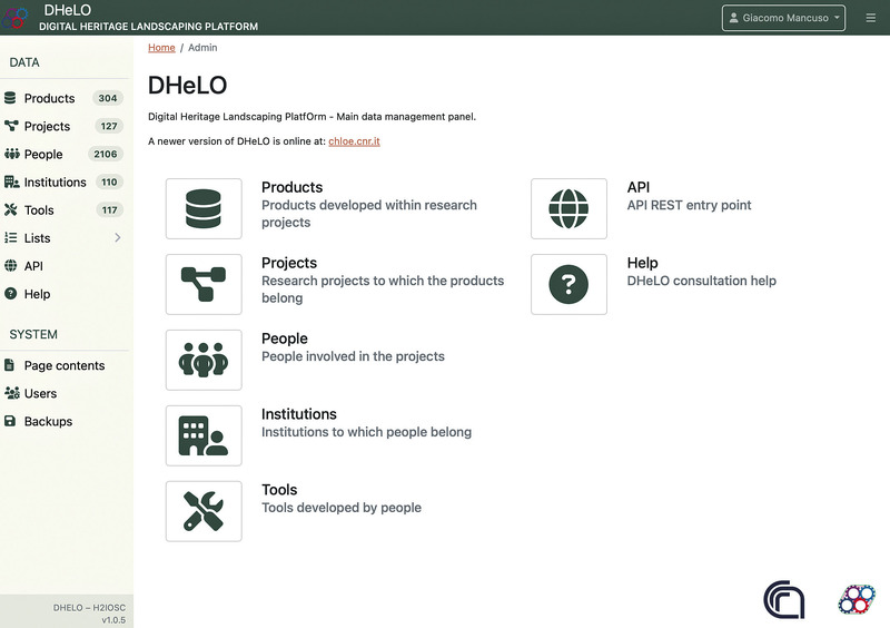
This article presents the transformation of DHeLO (Digital Heritage Landscaping Platform) from a relational database into a Linked Open Data (LOD) infrastructure, designed to enhance the discoverability, interoperability, and reuse of digital resources within Cultural Heritage (CH), Heritage Science (HS), and Digital Archaeology (DA) research. Initially conceived within the H2IOSC project as a virtual observatory for cataloguing digital products, tools, and research projects, DHeLO has been restructured as a service-oriented system in response to emerging community needs and a broader reflection on its role. The transition was guided by insights gained from landscaping activities conducted within Work Package 2, including questionnaires and interviews with members of the DH, DA, and HS communities. The new configuration of DHeLO integrates metadata on research outputs, projects, people, and bibliographic references, laying the foundation for a knowledge graph that mirrors the research landscape. A key step in this evolution was the adoption of Omeka S as the core platform, chosen for its modularity, semantic interoperability, and synergy with Zotero, which supports the integration of the BiDiAr bibliographic database. In this form DHeLO aspires to become an active research resource, moving beyond mere monitoring to foster exploratory analysis and linked knowledge networks.
Heritage science is an established and thriving field of enquiry. Initially considered as inherently cross-disciplinary, encompassing both the needs of conservators and practitioners and the high-quality evidence produced by scientists, heritage science has, through its expansion in recent years, formed a discipline in its own right. Here, we examine how heritage science can, and to an extent has, moved beyond the straightforward scientific analysis of historical materials and artefacts through an exploration of heritage science’s interactions with four key themes: (i) historical and archival research, (ii) conservation practice, (iii) policy at governmental, organisational and institutional levels, and (iv) a view to how new technologies, such as machine learning and artificial intelligence, can shape the future of heritage science. Much of the review narrative is framed via the analysis of UK-based case studies; however, they deal with issues that are international in nature (universal) and therefore transcend the UK context. Taken together, we demonstrate that heritage science as a discipline is capable of directly instigating or (re-)framing new areas or avenues of research, as well as enhancing and feeding into existing research questions, and has adapted and evolved along with emerging technologies and funding opportunities.
The growing use and increasing sophistication of GIS methods to manage archaeological data is not related to an increase in diversity of use. After two decades on a trial basis, we evaluate in this paper the current ability of Spanish Archaeological GIS applications to meet the expectations placed upon them, especially concerning their role in archaeological method and theory. The purpose of this paper is threefold. Firstly, we summarize the main trends in Spanish GIS-based applications over the last years using a sample of the most recent bibliography. Secondly, we critically examine and evaluate the inherent shortcomings of some existing GIS applications, and finally we review different underlying conceptions of space in GIS projects and propose how such a software can be integrated into a proper theory of social space.
Landscape archaeology, as a type of research based on a systemic surface survey and that results in quantifiable datasets of high quality, has started to be practiced in southeastern Arabia only in recent years. In this paper, I will briefly review the short history of landscape archaeology in the area and its relevance. I will then present the approach and methods used in the Wadi al Jizzi Archaeological Project and discuss some of the results obtained to discuss both the potential and problems of the data that the project generated. In particular, I will focus on ephemeral sites and assemblages, data quality and data representativity.
3D modelling and the connected digital representation forms have by now become commonplace in the design, knowledge and communication of Architecture. The relevance of a 3D model exceeds though the mere representation purposes. It directly refers, in fact, to its heuristic potential in enlightening the geometric structure, the hypothetical shape and even the building technology underneath an architectural object. From this specific perspective, this paper will illustrate two researches both dealing with the Vatican: the former focusing on the reconstruction of the site “the day before” the moving of the Vatican Obelisk by Domenico Fontana, the latter on the digital replica of the wooden model of Antonio da Sangallo for the new St. Peter Basilica. La modellazione 3D e le conseguenti forme di rappresentazione digitale sono ormai diventati strumenti correnti ed indispensabili nella progettazione, conoscenza e comunicazione dell’Architettura. Tuttavia la costruzione di un modello 3D può non solo condurre alla rappresentazione dell’oggetto ma anche assumere un valore euristico descrivendone la genesi geometrica, l’aspetto più probabile ed anche la tecnologia di costruzione. Il contributo illustra le esperienze condotte sulla Basilica Vaticana con la ricostruzione sia del sito all’epoca dello spostamento dell’obelisco guidato Fontana, sia del modello ligneo di Sangallo per il Nuovo San Pietro.
The Maya. The Romans. The great dynasties of ancient China. It is generally believed that these once mighty empires eventually crumbled and disappeared. A recent trend in archaeology, however, focusing on what happened during and after the decline of once powerful societies has found social resilience and transformation instead of collapse. In Beyond Collapse: Archaeological Perspectives on Resilience, Revitalization, and Transformation in Complex Societies, editor Ronald K. Faulseit gathers scholars with diverse theoretical perspectives to present innovative approaches to understanding the decline and reorganization of complex societies. Essays in the book are arranged into five sections. The first section addresses previous research on the subject of collapse and reorganization as well as recent and historic theoretical trends. In the second section, contributors look at collapse and resilience through the concepts of collective action, eventful archaeology, and resilience theory. The third section introduces critical analyses of the effectiveness of resilience theory as a heuristic tool for modeling the phenomena of collapse and resilience. In the fourth section, contributors examine long-term adaptive strategies employed by prehistoric societies to cope with stresses. Essays in the fifth section make connections to contemporary research on post-decline societies in a variety of time periods and geographic locations. Contributors consider collapse and reorganization not as unrelated phenomena but as integral components in the evolution of complex societies. Using archaeological data to interpret how ancient civilizations responded to various stresses—including environmental change, warfare, and the fragmentation of political institutions—contributors discuss not only what leads societies to collapse but also why some societies are resilient and others are not, as well as how societies reorganize after collapse. The implications of the fate of these societies for modern nations cannot be underestimated. Putting in context issues we face today, such as climate change, lack of social diversity, and the failure of modern states, Beyond Collapse is an essential volume for readers interested in human-environment interaction and in the collapse—and subsequent reorganization—of human societies.
With the adoption of Semantic Web technologies, an increasing number of vocabularies and ontologies have been developed in different domains, ranging from Biology to Agronomy or Geosciences. However, many of these ontologies are still difficult to find, access and understand by researchers due to a lack of documentation, URI resolving issues, versioning problems, etc. In this chapter we describe guidelines and best practices for creating accessible, understandable and reusable ontologies on the Web, using standard practices and pointing to existing tools and frameworks developed by the Semantic Web community. We illustrate our guidelines with concrete examples, in order to help researchers implement these practices in their future vocabularies.
Personal computers are able to organise complex information and to develop didactic experiences. In particular, new software makes use of audiovisual techniques, controlled by the computer, to create interactive experiences. This article discusses some of the principal interactive programs utilised in art exhibitions and highlights the power of multimedia programs in didactic activities. Some suggestions are also made regarding the use of multimedia programs.
Hypertext allows a personalisation of the information, with the possibility of creating multiple manuals with various levels of complexity. Therefore, Hypertext is an excellent didactic tool for education, and indeed schools frequently use hypertext to explain historical and artistical questions about Cultural Heritage.
Research has demonstrated the utility of digital aerial photogrammetry (DAP) for area-based predictions of forest inventory attributes. To date, studies have used DAP data acquired with a range of spatial resolutions and image overlaps. The systematic benchmarking of DAP acquisition parameters remains an outstanding research and operational gap for forest applications. While the impact of along-track overlap on point cloud metrics and area-based attribute estimates can be readily simulated, the impact of image resolution or across-track overlap requires purpose-acquired data. Moreover, although increases in along-track overlap are enabled by digital camera systems, costs for increasing across-track overlap can be substantial and may negate the cost-effectiveness of DAP for forest inventory. Hence, determining the impacts of varying acquisition parameters is of practical value for inventory programs. Researchers and practitioners have often assumed that more overlap will result in better DAP data, and that minimal overlaps often associated with historic airborne image campaigns are inadequate to support DAP processing. In our study, we found no marked difference among 15 and 20 cm spatial resolutions and overlap scenarios unless across-track overlap was reduced to 40%. Mean differences between DAP metrics and the ALS reference generally increased with decreasing overlap, and mean differences were larger for lower height percentiles (p10). Estimates of canopy height using the p90 metric varied by a root mean squared difference (RMSD) of approximately 5% between 15 cm and 20 cm datasets when along-track overlap was greater than 40%. Lower height percentiles were more strongly impacted by overlaps and resolution. Cover metrics varied by 2% RMSD across all overlap scenarios and resolutions. Comparisons between forest types (conifer, deciduous, mixed), terrain slope and aspect, and ALS-derived canopy cover were conducted to determine whether significant mean differences existed between DAP and the ALS reference. Although some significant differences were found by forest type and terrain variables, significant differences were most commonly associated with canopy cover. Based on the results reported herein, along and across-track overlaps ≥ 60% result in DAP metrics that were more similar to ALS. Increasing across-track overlap from 60% to 80% did not consistently improve the level of agreement between DAP metrics and ALS reference metrics. Conversely, DAP metrics generated using across-track overlaps <60% resulted in metrics with greater differences from the ALS reference, and a greater range of variability in DAP metric values. Image acquisitions for forest inventory must consider a broad range of factors and herein we have quantified that increasing along- or across-track overlap beyond 60% does not improve agreement with ALS area-based point cloud metrics commonly used to model forest inventory attributes. Likewise, overlap that is <60% does result in greater differences with ALS reference. Other applications beyond forest inventory may have different overlap requirements.
This paper aims to present the advantages of including auralisation techniques in archaeology. Archaeology can benefit from auralisation under several aspects. Not only does it offer the possibility to live a unique experience listening sounds originated within ancient buildings, but it allows to formulate subjective interpretations of the quality of the audio of a specific space. In addition, the subjective feeling evoked by the auralised audio can be further investigated through psychoacoustics analysis. The combination of archaeology and auralisation is also attractive for the general public thanks to digital applications that can be employed for educational purposes. The involvement of society through digital applications is important to bring it near to research and archaeology. After a short literature review about the implementation of archaeology, auralisation and digital applications, the final elaboration of a PhD research will be presented: the development of a virtual reality app that shows the 3D reconstruction of six Roman theatres in Crete, including the virtual auralisation from different seats within the theatres. The VR app is the ultimate product of a research that studied hypothetical reconstructions of the Roman theatres in Crete through 3D visibility analysis and virtual acoustics analysis. Through the VR app, users will not only experience an ancient performance in different Roman theatres, but they will also be able to observe the influence of architecture on the sound.
Beginning JSON is the definitive guide to JSON - JavaScript Object Notation - today’s standard in data formatting for the web. The book starts with the basics, and walks you through all aspects of using the JSON format. Beginning JSON covers all areas of JSON from the basics of data formats to creating your own server to store and retrieve persistent data. Beginning JSON provides you with the skill set required for reading and writing properly validated JSON data. The first two brief chapters of the book contain the foundations of JavaScript as it relates to JSON, and provide the necessary understandings for later chapters. Chapters 3 through 12 reveal what data is, how to convert that data into a transmittable/storable format, how to use AJAX to send and receive JSON, and, lastly, how to reassemble that data back into a proper JavaScript object to be used by your program. The final chapters put everything you learned into practice.
An important field of luminescence dating is the authenticity of ceramic art objects. The use of 'authenticity' instead of 'dating' is due to the ignorance of the ambient radiation, and hence the annual dose. The present paper shows a Bayesian approach able to quantify the degree of authenticity. This approach permits to introduce under mathematical models some assumptions (annual dose, fire, artificial irradiation) previously only presented as qualitative warnings in authenticity reports.
In 1998 the Laboratory for History, Archaeology and Topography of the Ancient World of the Scuola Normale Superiore in Pisa began an experiment with archaeological databases and GIS. Initially, we made a GIS for the Entella survey. Since then, the experiment on this sample-survey has become a more structured system for the management of archaeological data (excavations, surveys, pictures, artefacts, etc.). In particular, we have focused our attention on data normalisation. Since 2002 we have also used a GPS receiver for the Kaulonia survey in order to geo-reference the sites. At the moment, the GIS manages only survey data, but it could also include excavation data. Using this system we are able to create chronological maps, and analyse infra- and intra-site artefact distribution.
The present database was established during the special photographic and documentation survey of the Pompei archaeological area. This survey, promoted and realized by the Istituto Centrale per il Catalogo e la Documentazione, began in 1977 and until 1981 produced about 25,000 black and white photographs of paintings, floors and objects still in situ, and in the last years, about 4000 colour photographs. The database, initially devoted only to specialised users, contains the alphanumerical files relevant to this photographic survey, and is aimed in primis at the retrieval of images. In order to render the database accessible to a wider public, the programme needed an up-dating, which has been inserted in a more ambitious project, aimed at the creation of a CD-Rom containing the alphanumeric database and a good number of images.
The contribution focuses on some plastic vases from tomb 252 of the Monte Abatone necropolis in Cerveteri: in particular, a Corinthian ram-shaped vase and two Etruscan-Corinthian specimens in the shape of a human leg and a dying hare. It is precisely in relation to the latter that some considerations are made regarding the distribution of typologically similar specimens and the problematic location of the production centres. The manufacture of Etruscan-Corinthian plastic vases with linear decoration should be seen in relation to the figurative productions of the late cycles and, in this sense, the role of Cerveteri should undoubtedly be re-evaluated, as the specimens under examination seem to confirm. Finally, the question of the possible symbolic function of these objects, often associated in several examples in the same context and in some cases referable to infantile contexts, will be addressed.
Southern Sweden, and especially the area around Malmo in southwestern Scania, is perhaps one of the most archaeologically investigated areas in the world. Our knowledge of the local Prehistory has greatly increased in the past decades although it is also the product of centuries of agricultural practices, urban expansion and a relatively early (18th-19th c.) interest for prehistoric monuments (e.g. burial mounds and megaliths). However, despite the deluging amount of available information (over 50,000 ancient sites recorded in Scania), their distribution is not homogeneous and archaeologists are restlessly trying to explain this pattern and its underlying causes. In addition, post-depositional factors (infrastructure works, agricultural practices, etc.) heavily affect site distribution and preservation, blurring the global interpretation. The aim of this paper is to reduce the impact of post-depositional factors on our interpretations on site distribution. In addition, the results can be used as a starting point for further and more elaborate analyses (spatial statistics and simulations). All the models presented here were computed in a reproducible way, relying on FOSS and open data only, in order to allow anyone interested to replicate the model and adapt it to their own purposes and study regions.
Twenty-four years ago in Baia, at the North end of the Bay of Naples, a group of archaeologists began a series of surveys. Their work made it possible to reconstruct the topographic structure of the ancient city and the creation of the "Parco sommerso di Baia". This article shows, for the first time, the volumetric reconstruction of a thermal bath of the Imperial age. Starting from an accurate survey of surviving walls, two digital models have been created: the first one shows them in an underwater environment, as they were in the 1984; the second model integrates the missing parts of the walls and roofs. In Campi Flegrei and Baia numerous villas, spas and roads are hidden underwater. Discovering and protecting this historical heritage is essential for the planning of research projects including digital multi-level models, in order to make this knowledge accessible to everyone and to preserve its memory.
Since 2019, the LAD team has been working on the digitisation of the Carte topographique de l’Égypte through a GIS platform. The data contained in this historical cartography, published in the early years 1800s, play a key role in research on the ancient Egyptian landscape, yet they show a still image from the late 1700s. Taking a step towards a Linked Open Data (LOD), this paper illustrates the work of updating the already published dataset of the hydrography of Napoleonic cartography by the LAD team, to which new information useful for the study of the Ancient Egyptian landscape will also be added.
This paper describes the context and the proposal for the extension of Building Information Modelling to built heritage in order to enhance information management during the investigation and restoration activities. The core of the presented model is the integration of a BIM-based modelling environment and a knowledge base developed by means of ontologies, in order to represent all the semantics needed for a comprehensive representation of the historical artefact.To test its features, the model has been applied to the real archaeological investigation process of the Castor and Pollux temple at Cori, Italy.
As digital practice in archaeology becomes pervasive and increasingly invisible, I argue that there is a deep creative potential in practising a cyborg archaeology. A cyborg archaeology draws from feminist posthumanism to transgress bounded constructions of past people as well as our current selves. By using embodied technologies to disturb archaeological interpretations, we can push the use of digital media in archaeology beyond traditional, skeuomorphic reproductions of previous methods to highlight ruptures in thought and practice. I develop this argument through investigating the avatars, machines, and monsters in current digital archaeological research. These concepts are productively liminal: avatars, machines, and monsters blur boundaries between humans and non-humans, the past and the present, and suggest productive approaches to future research., Avec la généralisation des pratiques numériques en archéologie, qui deviennent cependant de plus en plus imperceptibles, l'auteur soutient qu'il existe un vaste potentiel de créativité dans la pratique de l'archéologie cybernétique. Cette discipline s'inspire du posthumanisme féministe pour briser les limitations de nos préconceptions sur les gens du passé mais aussi sur nous-mêmes. L'emploi de technologies incorporées et de médias numériques en archéologie nous permet de dépasser les limites des reconstitutions traditionnelles et skeuomorphiques produites par des méthodes plus anciennes, de bouleverser nos interprétations et de mettre l'accent sur certains points de rupture dans la pensée et en pratique. L'auteur traite ce sujet à travers l'examen d'avatars, de machines et de monstres tels qu'on les représente de nos jours en archéologie numérique. Ces concepts, liminaires mais productifs car les avatars, les montres et les machines brouillent les frontières entre ce qui est humain et non-humain et entre le passé et le présent, nous permettent d'entrevoir des approches fructueuses en recherche. Translation by Madeleine Hummler, Als sich die Digitalisierung in der archäologischen Praxis durchsetzt und zunehmend unsichtbar wird, wird hier der Standpunkt vertreten, dass die Ausübung der Cyborg-Archäologie potenziell sehr kreativ sein könnte. Die Cyborg-Archäologie ist vom feministischen Posthumanismus beeinflusst und bietet die Möglichkeit, unsere beschränkten Vorstellungen der Menschen in der Vergangenheit aber auch von uns selbst zu überwinden. Mithilfe der verkörperten Technologien und Digitalmedien in der Archäologie können wir die Grenzen der traditionellen, skeuomorphischen Rekonstruktionen der älteren Methoden überschreiten, archäologische Deutungen stören und gewisse intellektuelle und praktische Bruchstellen aufzeigen. Dies wird hier anhand von Untersuchungen von Avataren, Maschinen und Monstern in der gegenwärtigen digital-archäologischen Forschung herausgearbeitet. Solche liminale aber produktive Auffassungen, weil die Avatare, Maschinen und Monster die Grenzen zwischen dem Menschlichen und Nicht-Menschlichen und zwischen der Gegenwart und der Vergangenheit verwischen, stellen vielversprechende Ansätze für weitere Forschungen dar. Translation by Madeleine Hummler
Automation in 3D reconstruction involves mainly two tasks: (i) image orientation and (ii) 3D scene reconstruction. Nowadays, automation in (i) can be considered solved for aerial photogrammetric projects, but a general and commercial solution is still pending in case of close-range image blocks. Here, the complexity and diversity of the network geometry make the automatic identification of the image correspondences a challenging task. In this paper we present a methodology to automatically orient a set of targetless close-range images taken with a calibrated camera and the following creation of 3D models with a multi-image matching algorithm. Several real cases, comprehending free-form objects (e.g. bas-relieves, decorations, etc.), building facades and images taken with UAVs are reported and discussed. Lastly, some preliminary results on a methodology for markerless camera calibration are presented.
Changing climatic conditions are contributing to faster deterioration of building fabric. Increasing number of heavy rainfall events can particularly affect historic and Cultural Heritage (CH) buildings. These evolving and uncertain circumstances demand more frequent survey of building fabric to ensure satisfactory repair and maintenance. However, traditional fabric surveys have been shown to lack efficiency, accuracy and objectivity, hindering essential repair operations. The recent development of reality capture technologies, together with the development of algorithms to effectively process the acquired data, offers the promise of transformation of surveying methods. This paper presents an original algorithm for automatic segmentation of individual masonry units and mortar regions in digitised rubble stone constructions, using geometrical and colour data acquired by Terrestrial Laser Scanning (TLS) devices. The algorithm is based on the 2D Continuous Wavelet Transform (CWT), and uniquely it does not require the wall to be flat or plumb. This characteristic is important because historic structures, in particular, commonly present non-negligible levels of bow, waviness and out-of-verticality. The method is validated through experiments undertaken using data from two relevant and highly significant Scottish CH buildings. The value of such segmentation to building surveying and maintenance regimes is also further demonstrated with application in automated and accurate measurement of mortar recess and pinning. Overall, the results demonstrate the value of the automatic segmentation of masonry units towards more comprehensive and accurate surveys.
In this paper I have tried to build a computational theory. In other words, a “theory” implemented in a computer program. When using a computational theory we try to solve scientific problems, that is to say, we do not retrieve data units, but we “instantiate” a solution for the problem. I have formalised the concept of an “archaeological problem” in the following way: how is an artefact (or set of artefacts) used by a community in a specific context. The task is then to evaluate the social uses of a specific set of artefacts (Final Situation or State) in terms of: a) their description, and b) all information available about the social, cultural or chronological context and about the human community who produced those artefacts (Initial Situation or State).We may then represent problem solving knowledge as a list of discrete and closed units. Those declarative units are successive states of the problem. We substitute equations for explicit sets of propositions. We can implement a set of answers and a set of decision rules for each one. The resulting program looks like a complex database and not like a mathematical procedure, and we may consider the problem-solving mechanism as a sequential search in a preexisting problem space, using a finite number of particular decision rules. Some interesting work has been done in mathematical representation of archaeological theories, but such approaches have not been very successful, maybe because social sciences cannot be exclusively represented by mathematical models, or because archaeologists are incapable to communicate between themselves using mathematical expressions. As a consequence, archaeologists tend to express their theories by means of linguistic sentences, which is inadequate, given the fact that natural language obstructs objectivity. A representation in terms of logical propositions appears then as the best representation tool available to build social theories. Artificial Intelligence scientists are now exploring this possibility. In this paper I propose an analogy between the structure of archaeological (and social sciences) theories and the mechanism of Turing Machines: given some empirical data (observation of the archaeological record) and a knowledge-base (constituted by high-level concepts and their middle-range correlates), we have to explain the particular case (the archaeological record) by means of the knowledge-base (the theory). The logical mechanism is modus ponens.
Inventories of a rock art site often do not include tracings due to time and budget constraints, however they are still important for aiding interpretation. While digital inventories from 3D models are expediting the documentation process, on-screen digitization is still tedious. We propose a method of automated tracing using open source spatial algorithms on enhanced 3D derivatives of an engraved rock art site. Automated tracing not only reduces time resources, but has also been suggested to improve interpretation by reducing subjectivity. We evaluate the results by comparing the automated tracing with on-screen digitization. While some subjectivity may be reduced with automatization, there is still subjectivity in the choice of parameters.
Publication and usage of linked data has been highly pursued by cultural heritage institutions and service providers in this domain. Much research and cooperation are taking place in adapting and improving cultural heritage data models for linked data and in defining ontologies and vocabularies, as well as the setting up of services based on linked data. This article presents an evaluation of ontologies and vocabularies published as liked data, which originate from the cultural heritage domain, or are frequently used and linked to in this domain. Our study aims to evaluate their usability by crawlers operating on the web of data, according to specifications and practices of linked data, the Semantic Web and ontology reasoning. We evaluate having in mind the use case of general data consumption applications based on RDF, RDF Schema, OWL, SKOS and linked data's guidelines. We have evaluated twelve ontologies and vocabularies and identified that four were not fully compliant, and that alignments between ontologies are not included in the definitions of the ontologies. This study contributes to the research of novel services consuming linked data. It also allows to better assess the automation that can be achieved to handle the variety and large volume of linked data, when assessing the viability of new services based on linked data in cultural heritage.
The accurate 3D documentation of architectures and heritages is getting very common and required in different application contexts. The potentialities of the image-based approach are nowadays very well-known but there is a lack of reliable, precise and flexible solutions, possibly open-source, which could be used for metric and accurate documentation or digital conservation and not only for simple visualization or web-based applications. The article presents a set of photogrammetric tools developed in order to derive accurate 3D point clouds and orthoimages for the digitization of archaeological and architectural objects. The aim is also to distribute free solutions (software, methodologies, guidelines, best practices, etc.) based on 3D surveying and modeling experiences, useful in different application contexts (architecture, excavations, museum collections, heritage documentation, etc.) and according to several representations needs (2D technical documentation, 3D reconstruction, web visualization, etc.).
Qanats in northern Xinjiang of China provide valuable information for agriculturists and anthropologists who seek fundamental understanding of the distribution of qanat water supply systems with regard to water resource utilization, the development of oasis agriculture, and eventually climate change. Only the tops of qanat shafts (TQSs), indicating the course of the qanats, can be observed from space, and their circular archaeological traces can also be seen in very high resolution imagery in Google Earth. The small size of the TQSs, vast search regions, and degraded features make manually extracting them from remote sensing images difficult and costly. This paper proposes an automated TQS extraction method that adopts mathematical morphological processing methods before an edge detecting module is used in the circular Hough transform approach. The accuracy assessment criteria for the proposed method include: (i) extraction percentage (E) = 95.9%, branch factor (B) = 0 and quality percentage (Q) = 95.9% in Site 1; and (ii) extraction percentage (E) = 83.4%, branch factor (B) = 0.058 and quality percentage (Q) = 79.5% in Site 2. Compared with the standard circular Hough transform, the quality percentages (Q) of our proposed method were improved to 95.9% and 79.5% from 86.3% and 65.8% in test sites 1 and 2, respectively. The results demonstrate that wide-area discovery and mapping can be performed much more effectively based on our proposed method.
The paper presents a new method in analysing archaeological data using computer programs-mainly AUTOCAD with AME. The method combines recording of archaeological field work (such as survey topographical maps, drawing plans and sections) - with analysing layers, strata and artifacts in 3-D view. It was also used in other projects in this region, mainly for studying large architectural elements. Our method provides a more accurate device, and opens new possibilities in examining current archaeological issues.