The National Geoportal for Archeology (GNA), started in 2017 by the Central Institute for Archeology (Istituto Centrale per l’Archeologia – ICA) of the Italian Ministry of Culture, has the primary goal of making data resulting from all archaeological investigations carried out on the national territory freely accessible online. The project is part of the activities carried out by the Institute regarding the register and digitalization of archaeological research data. Its primary function is the creation of a dynamic archaeological map, easily implementable over time, free to access and easy to consult, open to reuse and integration by all users. The data-entry according to the GNA standard is entrusted to the use of a pre-set GIS project (template) developed using the open source software QGIS. GNA also receives data from other projects designed or managed by the Superintendencies in some areas of Italy, with the aim of preserving good practices already tested locally.
A specific relational database has been created for the management of small finds found on the Cretan sites of Phaistos and Ayia Triada in Crete. Such artifacts have been often underestimated in past archaeological studies, because of the perception that they are less relevant objects in comparison to other categories such as pottery. The database GEAR has been created to improve the recognition of their potential. This article presents the possible solutions used in the database to overcome some methodological problems: specifically two of the methodological aspects that have been dealt with are standardization and management of the reference sources and typological attributions. In the first case, a standard typological terminology (recommended by the ICCD) is used to assure data normalization; in the second case, the preservation of the subjectivity and uncertainty of archaeological attributions is obtained with the application of fuzzy logic and its concept of ‘probability of belonging’.
Documenting the relevant aspects in digitisation processes such as photogrammetry in order to provide a robust provenance for their products continues to present a challenge. The creation of a product that can be re-used scientifically requires a framework for consistent, standardised documentation of the entire digitisation pipeline. This article provides an analysis of the problems inherent to such goals and presents a series of protocols to document the various steps of a photogrammetric workflow. We propose this pipeline, with descriptors to track all phases of digital product creation in order to assure data provenance and enable the validation of the operations from an analytic and production perspective. The approach aims to support adopters of the workflow to define procedures with a long term perspective. The conceptual schema we present is founded on an analysis of information and actor exchanges in the digitisation process. The metadata were defined through the synthesis of previous proposals in this area and were tested on a case study. We performed the digitisation of a set of cultural heritage artefacts from an Iron Age burial in Ilmendorf, Germany. The objects were captured and processed using different techniques, including a comparison of different imaging tools and algorithms. This augmented the complexity of the process allowing us to test the flexibility of the schema for documenting complex scenarios. Although we have only presented a photogrammetry digitisation scenario, we claim that our schema is easily applicable to a multitude of 3D documentation processes.
The results of two distinct projects on two pre-Roman funerary areas are presented: the eastern necropolis of Padova between via Tiepolo and via S. Massimo (excavations 1990-1991), and the northern necropolis of Este in the area of Casa di Ricovero (excavations 1983-1993). The first project focused on building of a geodatabase to manage and archive documentation data, as well as to consciously plan resources allocation and research steps. The second project, on the other hand, focused on 3D reconstructions of two burial mounds in a BIM environment, with both research and dissemination aims. Therefore, it was possible to experiment with the limits, potential, and effectiveness of this method in an unusual archaeological context, characterised by monuments built mainly with perishable materials and lacking architectural structures.
Archaeology operates in an increasingly data-mediated world in which data drive knowledge and actions about people and things. Famously, data has been characterized as “the new oil”, underpinning modern economies and at the root of many technological transformations in society at large, even assuming a near-religious power over thought and action. As the call for this Special Issue recognizes, archaeological research is socially and historically situated and consequently influenced by these same broader developments. In archaeology, as in the wider world, data is the foundation for knowledge, but its capacity is rarely reflected upon. This paper offers just such a reflection: a meditation on the nature of archaeological digital data and the challenges for its (re)use. It asks what we understand by data: its etymology and comprehension, its exceptionality and mutability, its constructs and infrastructures, and its origins and consequences. The concept of the archaeological data imaginary is introduced to better understand approaches to the collection and use of archaeological data, and a case study examines how knowledge is mediated and remediated through the data embedded in grey literature. Appreciating the volatility and unpredictability of digital data is key in understanding its potential for use and reuse in the creation of archaeological knowledge.
Actual 3D scanners based on the structured-light principle are opening to possibilities for creating detailed models (polygon populations) with micrometric resolutions. Consequently, highly detailed models allow specific investigations. This work focuses on 3D scanning and post-processing analysis/filtering of Ancient Near East finds, especially seals and cuneiform clay tablets, fragile artefacts that can hold a lot of semantic information beyond transliteration: e.g. seal impressions (figurative and textual sealings), fingerprint evidence, retracing and erased text. Behind the ease of use of portable structured-light scanners, hides the enormous potential for feature extraction and processing. Metric analysis (e.g. deviation analysis) coupled with the application of MSII (Multi-Scale Integral Invariant) filter enhance data extraction, changing the overall perception on details of the archaeological artefact.
Comprehensive Coverage of the Entire Area of ClassificationResearch on the problem of classification tends to be fragmented across such areas as pattern
This special section stems from discussions that took place in a forum at the Society for American Archaeology's annual conference in 2017. The forum, Beyond Data Management: A Conversation about “Digital Data Realities”, addressed challenges in fostering greater reuse of the digital archaeological data now curated in repositories. Forum discussants considered digital archaeology beyond the status quo of “data management” to better situate the sharing and reuse of data in archaeological practice. The five papers for this special section address key themes that emerged from these discussions, including: challenges in broadening data literacy by making instructional uses of data; strategies to make data more visible, better cited, and more integral to peer-review processes; and pathways to create higher-quality data better suited for reuse. These papers highlight how research data management needs to move beyond mere “check-box” compliance for granting requirements. The problems and proposed solutions articulated by these papers help communicate good practices that can jumpstart a virtuous cycle of better data creation leading to higher impact reuses of data., Esta sección especial nace de las discusiones que tuvieron lugar en uno de los foros del Congreso Anual de la Society for American Archaeology en 2017. El foro, Beyond Data Management: A Conversation about Digital Data Realities (“Más allá de la gestión de datos: Conversaciones sobre las realidades de los datos digitales”), abordó los retos que se plantean al fomentar una mayor reutilización de los datos arqueológicos digitales actualmente conservados en repositorios. Los participantes del foro sostuvieron que la arqueología digital va más allá de su interpretación tradicional como mera gestión de datos, argumentando que es necesario situar de manera mejor el intercambio y la reutilización de datos en la práctica arqueológica. Los cinco textos que conforman esta sección especial abordan temas clave que surgieron de estas discusiones: el desafío de ampliar el alfabetismo de datos mediante el uso de los mismos como herramientas de instrucción; estrategias para lograr que los datos sean más visibles, mejor citados y más integrados en el proceso de revisión por pares; y formas de crear datos de mayor calidad que se presten mejor a la reutilización. En estos trabajos se destaca además cómo la gestión de datos de investigación debe ir más allá del simple cumplimiento del requisito de “rellenar casillas” para su verificación. Los problemas y las propuestas articulados en estos comunicaciones pueden ayudar a implementar mejores prácticas de creación de datos, que a su vez resultarán en un mayor impacto en la reutilización de los mismos.
Seit der Wiederentdeckung des Heiligtums durch E.A. Dodwell zu Beginn des 19. Jahrhunderts gab es nur zwei Ausgrabungsprojekte: Zunächst legte P. Paris im November 1883 die antiken Überreste des Tempels frei. Anhand seiner Funde rekonstruierte er diesen als dorischen Peripteros mit 6 x 13 Säulen. Obwohl das Heiligtum der Athena Kranaia als eines der bedeutendsten in der Phokis galt, fand es selbst nach seiner Ausgrabung durch Paris wenig Beachtung in der Forschung. Erst über 100 Jahre später führten S.P. Dimaki und G.A. Zachos weitere Suchgrabungen auf dem obersten Felsplateau in direkter Tempelnähe durch. 2018 wurden zu Beginn des Projekts "Topographische Forschungen im Kephissostal" LiDAR-Scans erstellt, welche zahlreiche weitere - bisher unbekannte - anthropogene Anomalien im gesamten Bereich innerhalb der Temenosmauer zeigten.
Nowadays, new surveying technologies and 3D modelling techniques allow high precision reconstructions of lost historical contexts. Indeed, in recent times, modern and broader perspectives of the archaeological research push to analyze post-ancient contexts with stratigraphic methods. The case of study concerns granaries and barns erected in the Early-modern age on the ancient ruins belonging to the Complex of the Emperor Domitian (Roman Forum-Palatine). At the end of 19th century, these modern structures were demolished. Now, significant traces on the ancient architectures (3D photogrammetry survey) and the large number of iconographic sources (organized in a digital database) give the possibility to reconstruct this block of vernacular buildings, with significant implications both on the scientific documentation and on the dissemination.
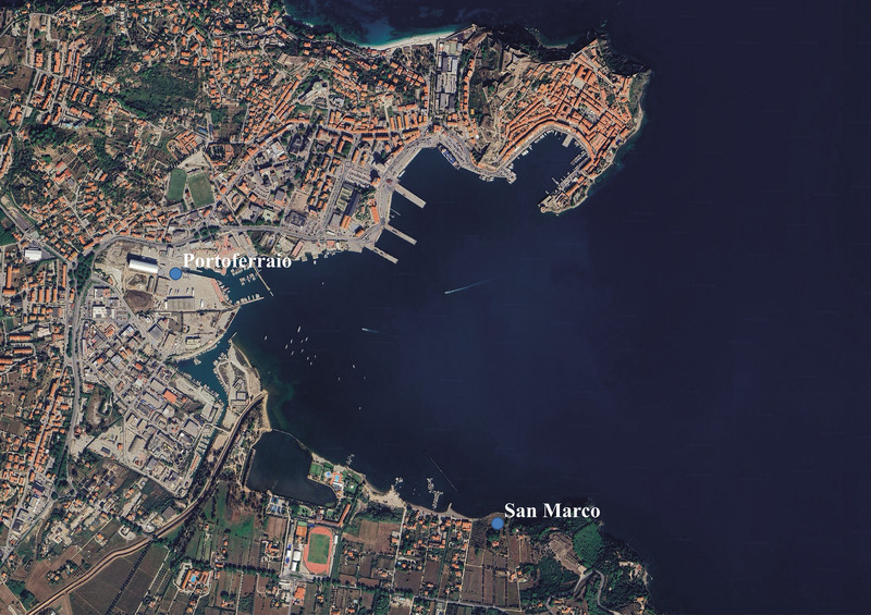
From 2012 to 2019, archaeological investigations were carried out at Podere San Marco in Portoferraio (Elba Island, LI), revealing a Roman villa dated between the late 2nd century BC and the 1st century AD. The building, mostly constructed with perishable materials, collapsed following a fire, after which the area was no longer inhabited. The large amount of archaeological data unearthed from the excavation allowed for a 3D reconstruction of the architectural complex, through the study of the collapses and the carbonized remains of wooden elements. To better manage the vast amount of information and ensure transparency regarding the reliability of the data, the Extended Matrix method was applied. The application of the method to the case of San Marco, specifically a stratigraphic excavation of collapsed structures made of perishable materials, has provided an opportunity to raise new methodological questions and formulate new hypotheses.
This paper presents the ongoing Ager Lucerinus project, as part of the Archaeological Map of Italy - Forma Italiae project. The main aim of the study was to undertake a complete historical reconstruction of the cultural landscape of the colonial territory of Luceria (Apulia), including the border area between the Tavoliere and the Daunian Subappennines. The extensive and systematic survey of the whole study area was combined with the collection of GPS georeferenced data integrated into an ad hoc GIS. All monumental and structural archaeological features, as well as scattered materials on the surface were georeferenced, their shapes and sizes perfectly represented. The paper also illustrates the project to safeguard the settlement at Chiancone (Pietramontecorvino) as a representative example of the synergy between Universities, the Superintendency and local authorities. The survey allowed us to identify a vast settlement dating back to the 5th-4th centuries BC. The extensive archaeological excavations undertaken in 2012 and 2014 confirmed the presence of a Daunian settlement and brought to light the earthen grave of a warrior, characterised by the richness of the grave goods. These data are also of great importance for understanding the boundaries and the connections between the so-called Daunian and Samnite territories, also confirmed by ancient literary sources.
This article is a short review of the history of representation and structuring of archaeological information in computer applications as from HW/SW growing technical development. In the seventies and eighties databases were the most popular and widespread application of computer technology to archaeology. In the eighties micro and personal computers dramatically increased database research projects. This uncoordinated growth led to a plethora of disparate systems incapable of information exchange, although this phenomenon did considerably increase the normalization and standardization of archaeological data. Starting at the end of the eighties, GIS application to archaeology became more and more popular and the number of GIS research projects quickly increased. In adopting GIS technologies, however, the archaeologist must be aware of problems connected with specific nature of spatial data (cartography is always a simplification of the real world) and their accuracy. In the last five years, network communication, and above all the Internet, have assumed a central role in archaeological research and the communication standard protocols derived from SGML will be a central tool for improving public access to the archaeological heritage and for enabling teaching and research.
This study investigates the application of digital replicas in Mixed Reality (MR) environments to enhance accessibility and foster engagement with archaeological heritage. The research centers on the Roman site of Forum Sempronii (Marche Region, Italy). Photogrammetry and 3D modeling techniques were employed to digitize artifacts, resulting in high-fidelity digital reconstructions. These replicas were recontextualized within their original archaeological settings, enabling a phygital experience that enhances visitors’ comprehension of the excavation and history of the site. The MR application, developed for the Meta Quest 3 headset, incorporates state-of-the-art graphics, intuitive navigational tools, and dynamic real-time lighting simulations to deliver an immersive user experience. By preserving the historical and spatial context of the artifacts, the project bridges the domains of museum conservation and archaeological interpretation. This methodological approach underscores the potential of MR to convey scientifically robust narratives while addressing the dual goals of accessibility and visitor engagement, making it suitable for diverse audiences. The framework proposed in this study serves as a replicable model for cultural heritage initiatives, demonstrating the effectiveness of integrating accurate digital replicas with interactive physical settings to reinforce the connection between artifacts and their historical environments.
The standardisation of records in archaeological work has permitted, notwithstanding some initial “resistence”, the massive introduction of computer science. In the field of post-classical archaeology the contribution of computers appears essential in comparison with data arising from written documentation. The latter appears to be of such dimension and quality that it has led to the formation of a historiographical tradition that is not used to dealing with archaeological research. Cartographic computerisation and image processing represent another sector which is developing in the post-classical field in order to study city-planning and building. This leads to an interdisciplinarity which is becoming extremely stimulating.
The widespread integration of digital technologies in the field of archaeology, facilitated by increasingly powerful and economically accessible tools, is producing a profound transformation in the conventional methodologies employed by archaeologists. This contribution specifically delves into the documentation of excavation phases and artifacts, presenting a workflow tested on the tomb 27 of the Colle Vaccaro necropolis (AP) within the educational project managed by the Istituto Centrale del Restauro (ICR). The digital representation of distinct layers and artifacts, developed together with with micro-excavation and restoration operations, serves as a tool for real-time analysis and documentation. Crucially, it acts as a foundational element for constructing an information system geared towards subsequent and more comprehensive historical-archaeological analyses. The outcome of this contribution is the formulation of a semi-automatic process designed to ensure a geometrically accurate and informed three-dimensional representation. This workflow for documenting an excavation and its artifacts is designed to facilitate efficient data utilization both for scholars and professionals.
The examination of archaeological documents preserved in the IBM archive outlines the development and the methodological tendencies which characterised, from the end of 1950's until the 1970's, the application of computer science in this field of study. The phases regarding technological development are described, as are the procedures relative to research projects of various subjects, both linguistic and strictly archaeological. These experiences show that, right from the beginning of the application of computers in archaeology, the tendency was to exploit their logical and mathematical potential.
La Palestina, la religione e l'archeologia. Parole evocative di luoghi, storie, immagini, popoli, libri sacri, divinità, personaggi e monumenti. Ma esse sono in questo testo anche qualcosa di diverso. La Palestina antica, una regione dai confini geografici, politici e culturali difficili da definire, è qui intesa come una vasta area che comprende l'intero levante meridionale, dalla Cisgiordania alla costa filistea, dal deserto del Negev alle zone meridionali di Fenicia e Siria. Non si parla quindi solo dei regni di Israele e Giuda ma anche di Filistei, Moabiti, Ammoniti, Edomiti, Aramei e Fenici.
In this paper we present an interdisciplinary project which is a work in progress towards a 3D Geographical Information System with a specific focus application on the Castle of Shawbak. The Shawbak archaeological project is a specific and integrated project between medieval archaeological research and computer vision done thanks a long-term cooperation between University of Florence and LSIS/CNRS Marseille. Focusing mainly on stratigraphical analysis of upstanding structures we conducted a survey using photogrammetry, both in a traditional way and using the most advanced techniques to obtain a dense map, and then a tool for statistical analysis. The photogrammetric survey is driven directly by archaeological data which is formalized by ontologies as a link between all the archaeological concepts which are surveyed. The 3D GIS is the last step of this chain and aims at the automatic production of 3D models through archaeological database queries: these 3D models are, in fact, a graphic image of the database and at the same time the interface through which the user is able to modify it and produce different kinds of analysis.
Previous studies conducted on the Mausoleum of Galla Placidia (between AD 432 and AD 450) have allowed us to identify the geometric rule used for the creation of its starry sky and to propose the initial considerations about the morphology of its pseudo-dome. At first sight, the turns of the stars describe regular circumferences that seem to lie on a plane, in reality their trend is a space curve resulting from a projection on the surface of the ceiling from a point centrally located, approximately at the height of the base of the windows. The geometry underlying this tracing is based on a series of cones whose angle at the vertex increases progressively, and whose materialization is possible thanks to the knowledge of the operating principle of the astronomical instrument called Triquetro and Ptolemy’s table of chords. Apparently irregular, the ceiling is set on a parallelogram and is not traceable to operations of revolution of a curve, a cross vault or a pavilion vault. The section of the mesh with a set of horizontal planes with a distance of 10 cm has generated a set of curves, all different from each other, which we perceive connected by an unusual rule, not yet investigated. An initial analysis allowed to verify that we are dealing with hyperbolas. The present work proposes to continue the investigation of these curves and to hypothesize a construction technique that can be adopted in the context of a building site.
The aim of this paper is to explore the interaction between design and archaeology in building Museum engagement experiences. In particular, a case study from the Museo Archeologico Nazionale di Napoli (MANN) will be presented. This study was carried out as part of OBVIA - Out Of Boundaries Viral Art Dissemination, a joint public engagement project sponsored by the Museum and partners such as the Università degli Studi di Napoli ‘Federico II’ and the Università degli Studi della Campania ‘Luigi Vanvitelli’. The target of the project was to stimulate innovative communication and promotion actions. Specific research activities carried out by the Dipartimento di Architettura e Disegno Industriale dell’Università degli Studi della Campania ‘Luigi Vanvitelli’, were dedicated to the development of Experience Design strategies for museum engagement and audience development. This study resulted in the creation of kits to be used during hands-on laboratories for children. The kit ‘Museum Details’ focused on the observation and reproduction of details of archaeological artifacts exhibited in the Museum. These kits included a map, instruments for detailed observation, moulding clay and casts to create 3D reproductions of original archaeological details. The necessity of a high detailed reproduction of small features of archaeological findings was an opportunity to experiment with the acquisition of accurate 3D models. In particular, the work carried out by Mnemosyne3D focused on five findings from the Magna Graecia collection. The main challenge was to detect sub-millimetric details on a reflecting surface. Photogrammetry was chosen as method for 3D scanning, a structure from motion acquisition technique. The post processing, through 3D sculpting and CAD 3D software, aimed to enhance the features of the models in order to make them suitable for casting and plastic reproductions.
The aim of this paper consists in analysing family-structure in a Roman community (Ariminum) using epigraphical data. Patriarchal extended family (typical of Mediterranean area) was absent in Roman age and besides we note the presence of nuclear family. Ariminenses had few children. It depends on several factors; for instance, on a high death-rate at birth, on a temporary situation of sterility in consequence of prolonged nursing, birth-control, food, living standards. Death-rate is high in the age-band 16-30 years, but only 10% of the documents contain biometric data, whose presence is closely related to the reader's emotions it could stir up.
L’adozione del BIM costituisce un approccio innovativo al mondo delle costruzioni, esteso a tutto il ciclo di vita di un manufatto edilizio: migliore qualità di progetto e della sua comunicazione, tempi ottimizzati, riduzione di errori e di costi. Questo approccio, che ha notevoli implicazioni sulla cultura della progettazione e della costruzione, è supportato da strumenti informatici dei quali si ripercorre, in questo articolo, lo sviluppo dalle origini e l’adozione da parte del mondo professionale e industriale, analizzandone elementi caratterizzanti e aspetti critici significativi.
The paper presents a GIS platform for the management of archaeological warehouses located in the territory of the IV Municipality of Rome. The need to create a GIS was owed to the distribution of archaeological material in at least 15 different stores. The contents and provenance of the boxes and their archaeological material have been recorded. A GIS platform has been developed, based on QGIS Desktop (version 3.0) and a geodatabase built on PostgreSQL/ PostGIS. As a cartographic base, both the existing cartography in the WMS format and the free downloadable cartography in .shp format were used. Further, a single table was created, merging the existing tables of different formats from the various warehouses examined.
This document is the first iteration of recommendations for making semantic artefact FAIR. These recommendations result from initial discussions during a brainstorming workshop organised by FAIRsFAIR as co-located event with the 14th RDA Plenary meeting in Helsinki. We are proposing 17 preliminary recommendations related to one or more of the FAIR principles and 10 best practice recommendations to improve the global FAIRness of semantic artefacts. These initial recommendations should not be considered as a gold standard but rather as a basis for discussion with the various stakeholders of the semantic community. Deliverable 2.5 is a complete, reviewed and improved version of D2.2. D2.5 supersedes D2.2. PLEASE SEE THIS DOCUMENT: https://doi.org/10.5281/zenodo.4314320
CyberResearch on the Ancient Near East and Neighboring Regions provides case studies on archaeology, objects, cuneiform texts, and online publishing, digital archiving, and preservation. Eleven chapters present a rich array of material, spanning the fifth through the first millennium BCE, from Anatolia, the Levant, Mesopotamia, and Iran. Customized cyber- and general glossaries support readers who lack either a technical background or familiarity with the ancient cultures. Edited by Vanessa Bigot Juloux, Amy this volume is dedicated to broadening the understanding and accessibility of digital humanities tools, methodologies, and results to Ancient Near Eastern Studies. Ultimately, this book provides a model for introducing cyber-studies to the mainstream of humanities research.
This book collects articles from two different workshops organized in 2009 and 2010. The TAG (Theoretical Archaeology Group) Conference in Stanford (May, 1‐3, 2009) ‐ workshop on Cyber‐archaeology ‐ and the conference Diversifying Participation.
For decades, the supra-inflation increase of subscription prices for scholarly journals has concerned scholarly institutions. After years of fruitless efforts to solve this “serials crisis”, open access has been proposed as the latest potential solution. However, the prices for open access publishing are also high and are rising well beyond inflation. What has been missing from the public discussion so far is a quantitative approach to determine the actual costs of efficiently publishing a scholarly article using state-of-the-art technologies, such that informed decisions can be made as to appropriate price levels. Here we provide a granular, step-by-step calculation of the costs associated with publishing primary research articles, from submission, through peer-review, to publication, indexing and archiving. We find that these costs range from less than US$200 per article in modern, large-scale publishing platforms using post-publication peer-review, to about US$1,000 per article in prestigious journals with rejection rates exceeding 90%. The publication costs for a representative scholarly article today come to lie at around US$400. We discuss the additional non-publication items that make up the difference between publication costs and final price.