IIn the joint excavation project at the Monte Abatone necropolis of Cerveteri, the participating partners have continued and expanded the excavations in the southwestern part of the necropolis near the Tumulus Campana, which started in 2018. The aim was to complete the investigation of a cluster of early small tumuli as well as to examine some larger burial structures in the area, detected by previous geophysical investigations. Altogether, 15 new graves were examined as well as some anomalies in the geophysical survey east and north of the Tumulus Campana. Additionally, a survey campaign has been carried out to study more open visible burial structures at the western slope of the plateau, including a tomb-lined access to the plateau at the northern limit of the necropolis.
Vorbericht della campagna di scavo condotta dalle Università della Campania 'Luigi Vanvitell', della Tuscia e di Bonn nella necropoli ceretana di Monte Abatone. Evidenze tra prima metà del VII e VI sec. a.C.
Die Bundesregierung hat sich zum Ziel gesetzt, im Verlauf der 19. Legislaturperiode die Bereitstellung von Open Data im Rahmen eines zweiten Open-Data-Gesetzes auszuweiten, um die »Public Sector Information and Open Data – Richtlinie der Europäischen Union 2019/1024« in nationales Recht umzusetzen. Mit einer Änderung des § 12a des E-Government-Gesetzes soll eine möglichst umfassende Veröffentlichung von offenen Daten des Bundes erreicht werden. Es wird im vorliegenden Beitrag erörtert, wie sich die geplanten Gesetzesänderungen und die Änderungen weiterer Digitalgesetze auf die digitalen Inhalte der Datenbestände des Deutschen Archäologischen Instituts, die auf der Plattform iDAI.world bereitgestellt werden, auswirken.
Der erste Kaiser des Romischen Reiches, Augustus, war darauf bedacht, eine Dynastie zu begrunden. Als Nachfolger wurde schliesslich Tiberius aus der Familie der Claudier ernannt. Sein Bildnis wurden im gesamten Romischen Reich verbreitet, um den Herrscher bildlich bekannt zu machen. Der Band behandelt diese im Romischen Reich gefundenen Portrats des Tiberius. Dabei werden seine Bildnisdarstellungen in allen Medien der Kunst zusammengetragen und nach Typen gegliedert. Es folgt eine Analyse der jeweiligen Repliken mittels einer Kopienkritik/Replikenrezension um eine Vorstellung von dem jeweiligen Urbild zu gewinnen. Nach der Datierung der Portrattypen versucht Dieter Hertel die politische Aussage der Bildnisreprasentation zu ermitteln. Alle Portrats sind schliesslich mit einem Kurzkommentar und reicher Bibliographie katalogisiert und werden in einem umfassenden Tafelteil moglichst vollstandig dokumentiert.
The paper illustrates the role of interactive multimedia for museum professionals in Emilia Romagna region. Their introduction is affecting the role of the traditional museum, but their effectiveness for exhibition interpretation has not been explored in depth until now. The authors discuss the problems that museum professionals have had in the use, implementation and evaluation of multimedia: the main is the lack of an adequate communications strategy in the museum educational projects. The paper presents the results of a survey on the use of multimedia program in an archaeological museum in Emilia Romagna. The evaluation project was carried out with different groups of one targeted audience: schoolchildren. The evaluation has investigated if visitors spend more time with the objects after using the application or are they distracted and absorbed by the novelty of the technology, and in general if the program creates a positive attitude towards archaeology and museums.
«Archeologia e Calcolatori» (A&C) is an open access scientific journal that follows the Diamond Open Access model, ensuring free access to its content without any charges for authors or readers. One of the main challenges of this model is ensuring the long-term sustainability of the journals that adopt it. The consolidation and growth of A&C over the past two years have been supported by the involvement of the multidisciplinary research group surrounding the journal within the H2IOSC project, through various forms of collaboration and engagement. This synergy has contributed to strengthening the editorial initiative and its related activities, expanding its scope and potential scientific impact through the enhancement of its textual, bibliographic, and visual resources.
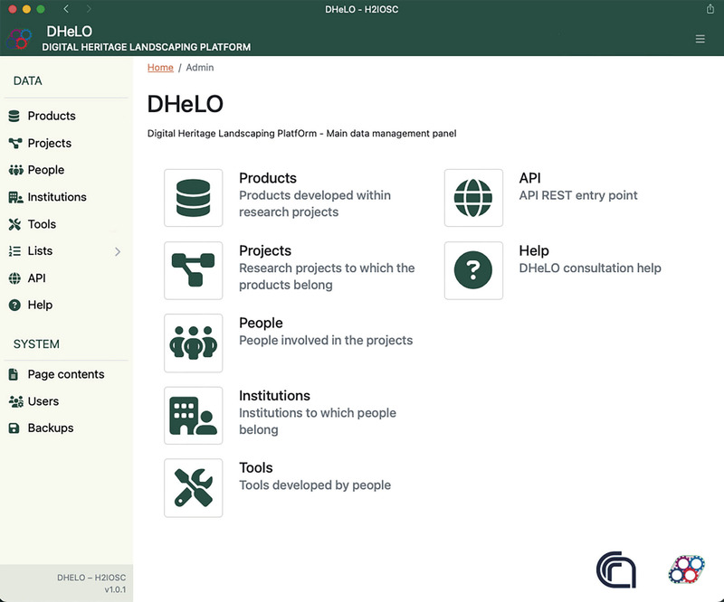
This paper explores the initial outcomes of the H2IOSC Project, specifically within Work Package 2 (WP2 - Landscaping & Building Communities), which aims to survey the Italian digital landscape in Language Technologies, Humanities, and Heritage Science (HS). A significant outcome of the efforts of the Rome branch of CNR-ISPC is the development of two key resources: the DHeLO web app and the BiDiAr bibliographic collection. DHeLO (Digital Heritage Landscaping Platform) is designed to collect, store, and query metadata of research projects, products, and digital tools in Cultural Heritage (CH) and Heritage Science (HS). It aims to create a comprehensive disciplinary observatory by integrating data from multiple sources into a structured system that allows for complex queries and data indexing. This platform supports the FAIR principles (Findability, Accessibility, Interoperability, and Reusability) and includes metadata standards based on the Dublin Core Metadata Initiative (DCMI). BiDiAr (Bibliography of Digital Archaeology) functions as a relational database within Zotero, an open-source bibliographic tool. It compiles bibliographic entries relevant to digital archaeology, integrating themes and research outputs from the 'Archeologia e Calcolatori' journal. This database aids in thematic trend analysis and network analysis by linking bibliographic citations, enhancing the understanding of research dynamics and impacts within the E-RIHS community. Analyzing these resources reveals an exponential increase in virtual reality and 3D modeling products, driven by epistemological developments and the disruptive use of photogrammetric modeling. These tools not only enhance data accessibility and usability but also support interdisciplinary collaboration and innovation in digital heritage and archaeology.
The Historic Atlas of Val-d’Oise is a tool with the objective to propose information concerning the evolution of the territory of Val-d’Oise. This application is an important step towards the development of the archaeological GIS project which is now a part of the Val-d’Oise Department project of GIS. The interpretation of the evolution of this project shows us how the archaeological methodologies develop with these tools, and how the informational and the technological foundation gives us the opportunity to develop this online application.
Virtual reality and 3D modeling techniques are increasingly popular modes of representation for historical artifacts and cultural heritage, as they allow for a more immersive experience. This article describes the process that was adopted for the development of a virtual reality application for four ships involved in the historic battle of Navarino. The specific naval battle was the culmination of military operations during the Greek Revolution in 1827, in which the allied British, Russian, and French fleet defeated Turkish-Egyptian forces. Representative 3D models of four significant warships that participated in the battle of Navarino were created: the British “Asia”, the French frigate “Armide”, the Russian “Azov”, and the Ottoman “Kuh-I-Revan”. These historic ships were digitally designed according to historical drawings and a VR battle environment was developed, which visitors can experience. In addition, the 3D models were generated by a 3D printer and painted according to the digitized ship-models. The development was conducted within the realm of the NAVS Project. The VR application, “The Ships of Navarino”, as well as the 3D-printed models were presented as part of a physical exhibition hosted in the Eugenides Foundation in Athens, Greece.
Structured-light scanning is a fast and efficient technique for the acquisition of 3D point clouds. However, the extensive and daily application of this class of scanners can be challenging because of the technical know-how necessary to validate the low-cost instrumentation. This challenge is worth accepting because of the large amount of data that can be collected accurately with the aid of specific technical protocols. This work is a preliminary study of the development of an acquisition protocol for anthropological remains performing tests in two opposite and extreme contexts: one characterised by a dark environment and one located in an open area and characterised by a very bright environment. This second context showed the influence of sunlight in the acquisition process, resulting in a colourless point cloud. It is a first step towards the development of a technical protocol for the acquisition of anthropological remains, based on the research of limits and problems associated with an instrument.
Heritage Science has a lot to gain from the Open Science movement but faces major challenges due to the interdisciplinary nature of the field, as a vast array of technological and scientific methods can be applied to any imaginable material. Historical and cultural contexts are as significant as the methods and material properties, which is something the scientific templates for research data management rarely take into account. While the FAIR data principles are a good foundation, they do not offer enough practical help to researchers facing increasing demands from funders and collaborators. In order to identify the issues and needs that arise “on the ground floor”, the staff at the Heritage Laboratory at the Swedish National Heritage Board took part in a series of workshops with case studies. The results were used to develop guides for good data practices and a list of recommended online vocabularies for standardised descriptions, necessary for findable and interoperable data. However, the project also identified areas where there is a lack of useful vocabularies and the consequences this could have for discoverability of heritage studies on materials from areas of the world that have historically been marginalised by Western culture. If Heritage Science as a global field of study is to reach its full potential this must be addressed.
In the framework of a collaboration between the Archaeological Park of Paestum and the University of Naples ‘L’Orientale’, in 2018 the study of the insula 4-6 of Paestum has been resumed. The paper shows the so-called ABIM (Archaeological Building Information Modelling) methodological approach that involves combining digital survey with parametric reconstruction of the structures. The study aims to provide a complete information system useful for different purposes, from documentation to interpretation and management of archaeological data, with a special focus on standards and interoperability. For this purpose, CISA (Centro Interdipartimentale di Servizi di Archeologia de ‘L’Orientale’) carried out an aerial digital survey to provide a detailed and updated map of all the structures still visible, while the point cloud was used to develop the archaeological BIM.
The Authors propose a knowledge map to analyse and access scientific contents related to Digital Archeology by leveraging various Machine Learning (ML) techniques. The case study concerns the articles published in our international journal «Archeologia e Calcolatori» in the decade from 2011 to 2020 and, as a benchmark, the publications in the ‘Computer Applications and Quantitative Methods in Archaeology’ (CAA) conference proceedings and journal. The titles and abstracts of the publications featured in these two data sets were analysed using a supervised classification approach into the subfields of computer science, based on the ACM’s taxonomy, and by applying topic modelling techniques to discover emergent topics, Named Entity Recognition to identify specific archaeologically relevant entities, and geotagging techniques to link articles with the geographical locations they discuss. The results achieved, although preliminary, provide some methodological suggestions: i) the opportunity to build custom analyses by taking advantage of the increasing availability of open data and metadata; ii) the scope of the contribution of archaeology, and in particular of computational archaeology, to the Heritage Science interdisciplinary domain; the heuristic and predictive role of different ML techniques to gain a multi-faceted access to data analysis and interpretation.
Archaeology has faced increased pressure to digitise collections and make artefacts available and accessible to a wider audience. 3D imaging involves producing a 3D digital or printed model of an object or site. 3D models have the potential to augment the traditional approaches to museum engagement whilst breaking down the barriers to access, whether through providing 3D printed proxies in museums or sharing digital models online. 3D imaging has clear value in archaeology and public engagement but there is no standardisation or accessible pipelines available for achieving professional 3D imaging output. There is very little consensus in 3D modelling and worldwide, digital collections are being created with no methodological consistency. This research observed each stage necessary for producing high-quality 3D models with structured light scanning (SLS) technology. SLS was effective on a range of textures that may be encountered in archaeological scenarios, although highly reflective objects, or pale objects with black areas, may fail to be captured even with an altered strategy. In order to make the 3D model most representative of the archaeological find, it is recommended that a range of scanner settings such as brightness or shutter speed are tested on the object before committing these settings to the rest of the scans. Generalised 3D scanning pipelines are provided to inform archaeological teams on a 3D digital and printing strategy.
Deux dessinateurs, Jean-Baptiste Muret et Jean-Charles Geslin, ont pendant des années dessiné des antiques au sein des deux principales collections archéologiques françaises : le premier au Cabinet des médailles de la Bibliothèque nationale de France, de 1830 à 1866, et le second au musée du Louvre, de 1863 à 1870.Qu’il s’agisse de bijoux, de bronzes ou de terres cuites polychromes, venus d’Orient, de Grèce ou d’Italie, les deux dessinateurs ont su créer une documentation scientifique et sensible, alliant la précision du regard archéologique et le talent de l’artiste. Leurs recueils, qui rassemblent plusieurs centaines de dessins largement inédits, témoignent d’une sorte d’âge d’or de la documentation graphique au sein des musées, au moment même du développement de la photographie.Ils constituent aussi une source de première importance sur le goût de l’antique au XIXe siècle et sur l’histoire de l’archéologie et des collections françaises et européennes.
Modern museum practice embraces equal access for all, but access for blind and partially-sighted (BPS) audience remains problematic given the ocularcentricity of museums. Many museum professionals and BPS visitors remain frustrated by the degree of accessibility on offer. The use of 3-D printed replicas as a handling surrogate represents a solution, allowing BPS visitors to engage tactually with museum content while minimizing risk. However, the design of such replicas is poorly researched. This exploratory examination of the design of 3-D printed replicas utilizes semi-structured interviews, sensory observations and content analysis to examine BPS perceptions of museum objects in the absence of interpretational support. Interpretation was dominantly multisensory, while participants found it easier to determine material traits than object traits, with textual, geometrical and optical properties being of use. Assistive approaches rather than major alterations were favored. Overall, museum professionals should consider how the process of 3-D printing influences BPS perception. (PsycInfo Database Record (c) 2022 APA, all rights reserved)
Nell’ambito del progetto e-Archeo, gestito dalla società ALES, si è svolta l’attività di rilievo fotogrammetrico di dettaglio della villa romana di Desenzano, con l’obiettivo di creare un’importante risorsa per la valorizzazione e al contempo di determinare un punto di partenza per l’elaborazione delle piante di fase e per la ricostruzione e modellazione 3D dell’edificio.<br> Per il rilievo della villa si è proceduto con l’acquisizione del dataset delle immagini tramite drone (Mavic 2 pro della DJI), ottenendo fotogrammi: nadirali, frontali e obliqui. Nel contempo è stata registrata la posizione dei punti di appoggio e di controllo, da usare nell’elaborazione fotogrammetrica per georiferire i rilievi.<br> Per la fase successiva di acquisizione ed elaborazione dei dati del progetto è stato utilizzato il software Agisoft Metashape (Structure-from-Motion). In seguito all’allineamento e all’ottimizzazione delle camere è stata generata la nuvola di punti densa, il meshing delle superfici e la texturizzazione del modello 3D. Dal set di dati ottenuto è stato possibile ricavare l’ortofoto dell’area della villa e di dettaglio dei settori A e B e il DTM dell’area della villa, quest’ultimo utile alla ricostruzione del paesaggio antico.<br> Gruppo di lavoro: F. Soriano e A. Zemignani.
Description de l'Egypte ou Recueil des observations et des recherches qui ont été faites en Egypte pendant l'expédition de l'armée française. Tome 2 / [par Edme- François Jomard... et al.] -- 1821-1830 -- livre
After presenting a summary of the development of computer applications in archaeology from the 1960s up to the present, the author discusses a diagram outlining the main processes which characterise the work of the archaeologist and specifically those in which computer methods have assumed an important role. The author identifies the following essential stages for the use of computers in archaeology: data gathering, data structuring, also for purposes of interpretation, and data diffusion, in order to make results known. This last stage seems to be particularly influenced by the developments brought about in recent years by the introduction of multimedia systems which have made the electronic publication of archaeological data possible by employing digital supports like CD-ROM as well as by creating Internet sites.
Philipp von Zabern - Damaszener Forschungen, Band 3. - Neuwertig erhalten. - Der Tempel von Ain Dara. Mainz 1990. 4to. 66 Seiten mit 10 Textabbildungen und 62 Tafeln mit 156 Abbildungen. Orig.-Leinenband.
This study on post-Roman Europe is the first to systematically examine and compare the media of seals and coins for diverse cultures, such as the Franks, Lombards, Anglo-Saxons, and Visigoths, over a period of 500 years. It focuses on political communication by means of the ruler’s image and the question of how it developed in specific media, which took place in very different ways despite a common heritage.
This article discusses the deployment of mobile data capture software developed by the Field Acquired Information Management Systems project (FAIMS Mobile) to document systematic pedestrian surface survey and legacy feature verification at the Perachora Peninsula Archaeology Project (PPAP), Greece, in 2020. FAIMS Mobile is an open-source platform that generates customized Android applications for data capture during field research. We reused and adapted two existing customizations from the FAIMS library for comprehensive digital recording of two workflows, integrating a collection of structured data, geospatial data, photos, and text. FAIMS Mobile required only modest hardware but supported offline setup, synchronization, and data export, allowing PPAP to deploy it despite unreliable internet access. The system proved successful; it was tailored to our aims and methods, captured consistent and well-described data rapidly, and minimized post-processing. All collected data was available daily for planning, and a comprehensive dataset adhering to Findable, Accessible, Interoperable, and Reusable (FAIR) data standards was ready for analysis with only a few hours of processing after fieldwork.
This paper provides a concise overview of the CIDOC Conceptual Reference Model (CIDOC CRM). The CIDOC CRM is a formal ontology initially developed for museums and cultural institutions to describe and organize their data. It serves as the ISO standard for representing museum and cultural heritage knowledge. The paper outlines the model’s core principles, advantages, challenges, and implications for its use, touching upon the CIDOC CRM’s relationship with the Semantic Web and challenges in implementing it with technologies like RDFS and OWL. It also highlights challenges in querying CIDOC-based knowledge graphs and integrating pre-existing heterogeneous data.
Purpose: Forensic facial reconstruction (FFR) is an auxiliary technique that approximates a face in order to generate identifications. Technological development allows access to open software that can be applied to FFR. The demonstrated protocol has features from creating 3D replicas of the skull to finishing and displaying the reconstruction. PPT GUI is used for 3D scanning, and the resulting point cloud is converted into a 3D mesh in MeshLab. The sculpture is made in Blender, according to the user’s preferred technique. The adaptation of the skin layer and finishing of the reconstruction is optimized with the use of templates. In this phase, details can also be hand-carved. Allied to basic training in the software featured in this protocol, the open access to these tools and its independence of imaging hardware other than digital cameras is an advantage to its application in forensic and research contexts.
DELTOS II is an information system covering the needs for documentation, conservation and administration of site monuments and preserved buildings. It offers map display, supports large data volume, storage and display of multimedia data (mostly images and free text) and drawing facilities. DELTOS has been developed by the Institute of Computer Science, FORTH, in dose collaboration with the 23rd Ephorate of Classical and Prehistoric Antiquities and the l3th Ephorate of Byzantine and Postbyzantine Antiquities. The system has been installed at the Archaeological Museum of Heraklion, Crete, Greece and is currently in the initial stage of exploitation.
Il contributo offre una visione di sintesi sulla tematica della organizzazione topografica delle necropoli del Veneto preromano, analizzando le principali evidenze strutturali di delimitazione ed organizzazione dello spazio e ponendole in rapporto sia con il dato linguistico che con quello del rituale funerario. Il tema è tratteggiato in evoluzione diacronica con uno specifico riferimento alle strutture del VI-V secolo a.C., specchio della piena evoluzione urbana e del momento dell’acquisizione di forme monumentali.
Il volume raccoglie i risultati del convegno sull'arte di fonder campane, organizzato dall'Istituto di Archeologia dell'Università Cattolica di Milano.Atti del Convegno ( 23-25 febbraio 2006)
High-resolution, freely available Google Earth software was successfully utilised in a remote-sensing survey to locate and map thousands of Hafit tombs in a study area centring on Wadi Andam in the Sultanate of Oman. This dataset was refined for reliability with ground-based fieldwork, and was analysed in the landscape using GIS software. The tombs are not randomly distributed across the study area; rather, the hydrology of the area appears to have been a dominant determining factor in the location of the graves. The structures were constructed in elevated, highly visible locations, possibly in an attempt to mark ownership of the landscape. The distribution of Hafit tombs is likely to provide some insight into the utilisation of the landscape in this period, with the evidence from Wadi Andam tentatively suggesting the presence of a nomadic pastoralist population. The development of this rapid, accurate and cost-effective methodology has the potential to greatly facilitate the survey and analysis of Hafit tombs across the Oman peninsula.
This research aims to use quantitative and repeatable GIS techniques, as well as Machine Learning algorithms, to study the settlement patterns in Southern Etruria during the final phase of the Bronze Age (1150-950/925 BC). The region of Southern Etruria is located in present-day Latium, Tuscany, and Umbria. The study, which includes 166 settlements, focuses on identifying the morphological characteristics of these settlements by means of raster analysis. Using a Machine Learning approach, the research will compare real settlements with random points within the region to understand the specific characteristics of the settlement pattern in the landscape. The study will also examine the use of feature selection and features importance methods to select the most significant features of a multivariate dataset.
Deeper neural networks are more difficult to train. We present a residual learning framework to ease the training of networks that are substantially deeper than those used previously. We explicitly reformulate the layers as learning residual functions with reference to the layer inputs, instead of learning unreferenced functions. We provide comprehensive empirical evidence showing that these residual networks are easier to optimize, and can gain accuracy from considerably increased depth. On the ImageNet dataset we evaluate residual nets with a depth of up to 152 layers - 8× deeper than VGG nets [40] but still having lower complexity. An ensemble of these residual nets achieves 3.57% error on the ImageNet test set. This result won the 1st place on the ILSVRC 2015 classification task. We also present analysis on CIFAR-10 with 100 and 1000 layers. The depth of representations is of central importance for many visual recognition tasks. Solely due to our extremely deep representations, we obtain a 28% relative improvement on the COCO object detection dataset. Deep residual nets are foundations of our submissions to ILSVRC & COCO 2015 competitions1, where we also won the 1st places on the tasks of ImageNet detection, ImageNet localization, COCO detection, and COCO segmentation.
In this paper, we report the results of our work on automated detection of qanat shafts on the Cold War-era CORONA Satellite Imagery. The increasing quantity of air and space-borne imagery available to archaeologists and the advances in computational science have created an emerging interest in automated archaeological detection. Traditional pattern recognition methods proved to have limited applicability for archaeological prospection, for a variety of reasons, including a high rate of false positives. Since 2012, however, a breakthrough has been made in the field of image recognition through deep learning. We have tested the application of deep convolutional neural networks (CNNs) for automated remote sensing detection of archaeological features. Our case study is the qanat systems of the Erbil Plain in the Kurdistan Region of Iraq. The signature of the underground qanat systems on the remote sensing data are the semi-circular openings of their vertical shafts. We choose to focus on qanat shafts because they are promising targets for pattern recognition and because the richness and the extent of the qanat landscapes cannot be properly captured across vast territories without automated techniques. Our project is the first effort to use automated techniques on historic satellite imagery that takes advantage of neither the spectral imagery resolution nor very high (sub-meter) spatial resolution.
A long-standing project concerning the study of the Bronze Age interrelations between the Aegean and Italy, in progress at the Istituto per gli Studi Micenei ed Egeo Anatolici, has stimulated the creation of an appropriate database. The relational database DEDALO is composed of six different files (1. sites, 2. excavation, 3. areas, 4. contexts, 5. finds and 6. bibliography), where information on the archaeological evidence related to Aegean-type material found in Italy is stored. The basic units of the structure are the sites where one or more Aegean items have been found. Although the entries of the fifth file, concerning items, are very detailed, DEDALO is not particularly object-oriented, but rather aims to integrate geographic, environmental, archaeological, chronological and archaeometric data, focussing on the relationship between the Aegean-type object (seen as the exception in its context) and the local Italian communities of the Bronze Age.
This review examines the discourses and practices that have produced a lively literature on museum decolonization created by scholars of museum practices and curators. We consider the trajectory of decolonization efforts in museums, focusing especially on the care of Native North American heritage, with comparison to similar trajectories internationally. We begin with a discussion of decolonizing moments in theory and practice, with particular attention to 1990s critique of ethnographic museums and developments after the passage of the Native American Graves Protection and Repatriation Act (NAGPRA). Following this discussion is a review of works on concerns regarding Native American representation and public displays, involvement in collections care, and the varied collaborations that are changing museum practices. The final section foregrounds the fluorescence of tribal museums and their contributions to the decolonization and indigenization of museums, as well as emerging paradigm shifts in both the anthropology of museums and anthropology in museums.
Over the years, the subject of archaeological publications, with regard to their style, format, content, and size, has been extensively debated. Nevertheless, all debates have axiomatically accepted that when talking about archaeological publications this automatically implies that we practically speak about the production of a book. Recent advances in Information Technology, supported by copyright legislative amendments, however, have forced us to reconsider this axiom; it is possible nowadays to replace the book, as we all knew it, with electronic presentation platforms and computer Cds. The computer hardware and software market now offers a variety of fairy sophisticated and relatively cheap off-the-shelf products that can be considered as both adequate and reliable publication platforms. Such a product is SPANS Explorer which is presented in this paper as an illustrative example.
This paper reports on the creation and use of a web database designed as part of the TiMMA project with the Content Management System Omeka S. Rather than resulting in a technical manual, its goal is to analyze the relevance of using Omeka S in the frame of a post-excavation project, gathering a wide team of researchers from several countries, working in their own language and having their own specialty. Designed to assist organizations and institutions in creating and managing digital collections, Omeka S offers a number of commodities from the perspective of both the administrator(s) and the users, the most significant being its efficiency in capitalizing on linked data standards for items description. Additionally, one of the successful achievements of this platform is to benefit the open-science tools more broadly, permitting for instance, as was done in this project, to import images with the iiiF API and bibliographical references with the Zotero module, thus avoiding the creation of new digital files and metadata. Designed with simplicity in mind, the graphic interface of Omeka S makes it a particularly appropriate tool for collective projects, permitting each user to perform a specific role and record data in their chosen language. This user-friendliness extends up to the data recording and publishing, as well as to the website designing which requires no specific skills in code. The TiMMA project also faces the limitations of Omeka S, such as the lack of efficiency of the search engine, which makes the use of web-semantic vocabularies difficult, a few bugs, and the absence of convenient functionalities in archaeological projects (e.g. the automatic creation of primary keys, a statistic dashboard, cells’ automatic filling). Despite these limitations, the TiMMA project contributes to showing that, without being a complete archaeological system recording, Omeka S is adapted to post-excavation projects.
Archaeological research must handle issues such as vagueness and uncertainty in data modelling. Especially vagueness and uncertainty must be modelled to work with geodata. However, for linking data and FAIRification graph-based modelling as Linked Open Data (LOD) proposed by Berners-Lee is the method and technique of choice. This paper discusses three data-driven interdisciplinary use cases of dealing with and modelling vague and uncertain geo-references (here especially findspots) based on literature as LOD from the archaeological and geosciences domain (Irish Ogham Stones, Campanian Ignimbrite, and Silver Coinage of Croton), implementing three modelling strategies using Wikidata, Linked Open Data and Wikibase.
For the past decade, libraries have battled declining university budgets and increasing serials expenditures. With each Big Deal package renewal or cancellation, librarians and publishers have asked themselves: Did I make the best deal? Did I make the right deal? Recent developments in open access promise to bring major reform to academic publishing and, with that, new challenges and opportunities to the way that librarians and publishers choose to deal.
"In dit boek worden de resultaten gepresenteerd van het archeologisch onderzoek dat in 1946-1947 in Vechten is uitgevoerd onder supervisie van A.E. van Giffen. In een aaneengesloten zone van 90x30 m en enkele losse putten en sleuven werden de
Les modalités d’usage d’instruments de pesée et le maniement de concepts de numération et de métrologie par les sociétés protohistoriques ont fait l’objet de peu d’études systématiques en archéologie. Cet ouvrage, issu d’une thèse doctorale, offre une analyse diachronique des poids et des éléments de balance découverts en Europe occidentale et datés entre les XIVe et IIIe s. a.C.
L’Institut national d’histoire de l’art (INHA) est un établissement public à caractère scientifique, culturel et professionnel destiné à promouvoir la recherche scientifique en histoire de l’art. Depuis plusieurs années, l’INHA s’est engagé dans une démarche de mise à disposition et d’ouverture des données (codes sources, métadonnées, publications, images) issues des programmes de recherche de l’Institut et de ses partenaires, auprès de la communauté scientifique et, plus largement, de toute la société.
Le chapitre 1 situe historiquement la notion de stratigraphie archéologique, de la fouille sans stratigraphie, à la stratigraphie verticale basée sur les coupes de terrain, puis à l'état de l'art actuel fondé sur l'axiomatisation proposée par Edward Harris en 1979. Le chapitre 2 est une relecture des concepts de cette dernière approche, préalable à leur formalisation. Celle-ci, développée dans le chapitre 3 en recourant à des outils mathématiques simples, permet de proposer un algorithme d'obtention du diagramme stratigraphique, intégrant la notion d'incertitude. Ce traitement s'insère dans la notion plus large de " système d'information stratigraphique " (chapitre 4). Enfin le chapitre 5 évoque, d'un point de vue théorique et pratique, le statut de l'information stratigraphique. <br /> Le volume 2 présente les outils informatiques issus de ce travail : le module de création de diagrammes stratigraphiques Le Stratifiant, et l'exemple de base de données Stratibase.