The group of bronze sheets with repoussé decoration, kept in the Ny Carlsberg Glyptotek and coming from the princely burial in Tomb XI at the Colle del Forno necropolis, has been identified as the decoration of a chariot and the magnificent upholstery from horse trappings. This group represents a collection of extraordinary interest regarding figurative culture in the Tiber river area in the Late Orientalizing Period, an identification proven by a second group of objects kept in the same museum. The decorative repertory represents one of the most refined expressions of the artistic style called “Orientalizzante fiorito”, which is best known from the decoration of bucchero pottery, carved ivories and ostrich eggs. Computer graphic techniques have been used for the documentation and study of this repertory, using as a base the excellent photographic documentation provided by the Glyptotek. This methodology, experimented through the use of a graphical workstation at the Istituto per l’Archeologia Etrusco-Italica, provides the opportunity to create a graphical documentation very close to the original technical and graphical cipher and qualifies itself as a very important tool for reading elements regarding the incision technique. However, close collaboration between the specialist and the archaeologist is essential in order to validate this as a useful scientific method of documentation.
Remote sensing, through orbital, airborne or close range images, is, today, the most accurate and suitable methodology to achieve an exhaustive investigation of a defined territory. It can be regarded as a great reservoir of any document left by past human societies, who settled in the studied area, from which it is possible to recover the spatial organisation of the culture produced by those societies. The multispectral images record both the reflected and the emitted energy; the latter is linked to the nature of the soil and, in particular, to standing structures. Through surface investigation, geophysical survey and accurate georeferencing, mainly by GPS receivers, it is possible to build a topographic information system to be integrated with the known information of all the preserved documents about the settlement system within the investigated region. Two case studies are discussed here: the area surrounding Palmyra in Syria and the territory of Selinus in Sicily; both illustrate, through newly discovered evidence, the results of the applied methodology.
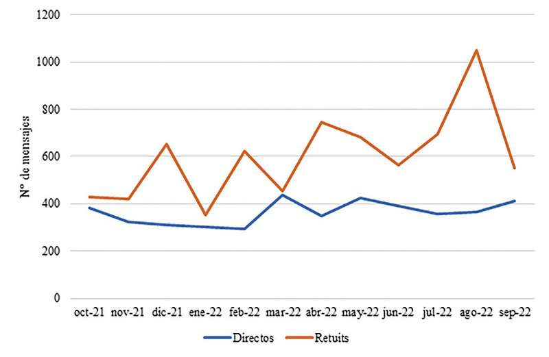
This work aims to investigate the feelings and emotions that Prehistory generates in the social network Twitter (today called X). To do this, the messages that, during a period of one year, contain the hashtag #prehistory, together with its possible variants, have been considered. The analysis has been carried out from an R programming environment, mainly through the Syuzhet library, that allows extrapolating feelings and emotions that underlie texts. However, the methodological proposal made in this paper is susceptible to being applied to different data samples related to other cultural manifestations or assets. From the point of view of the results obtained, it can be stated that the valence underlying the data sample analyzed can be considered as markedly positive. Regarding emotions, there is a predominance of anticipation and trust, followed by joy according to the model proposed by Plutchick, which is the one used in this work.
The SIAPVA is a project with a marked digital character in which the acquisition of data obtained through invasive (archaeological excavation) and non-invasive (3D laser scanner, drone and GPS) methodologies is integrated. The records of the different sources of information converge in a GIS in which all the documentation is managed. Within the framework of a new phase of research on the archaeological site, the study undertaken is based on Digital Humanities approach. The real power lies in the fact that reports, invaluable archival photographs and plans exists digitally. It is on this basis that the authors have been able to addressed the analytical questions about this outstanding place, the imperial palace of Villa Adriana.
In this paper we present the archaeological research project that in June 2017 started the Seminario de Arqueología at the Pablo de Olavide University in Seville and its first results. The project has two points of attention. The first one, the Casa de la Cañada Honda, is one of the most interesting examples of domestic architecture hitherto known in Italica. The house, barely studied until now, was partially excavated in the 70s. XX and, among other peculiarities, has the addition of an interesting stibadium attached to the source of the peristyle. The second point of attention, the southwestern angle of the late antique wall, forms part of a walled enclosure hitherto identified only through various geophysical surveys and that this project aims to define more precisely, both as regards its chronology and its constructive features.
La escasez de trabajos arqueológicos en la cuenca media del Guadalquivir determinó, en su momento, el inicio de las excavaciones en el Llanete de los Moros; ...
The role of Baetis estuary is analysed as a factor of first urban networks articulation, and territorial connectivity in Antiquity. This approach brings us a greater understanding of the terrestrial communications origins between the urban centres of this area. Also it reflects the progressive historical reorientation of the communication routes, which has generated an actual perception of this geography and their access that are far different from the previous organization in the Protohistory. Se analiza el papel del estuario del Baetis como factor de articulación de las primeras redes urbanas y de conectividad del territorio en la Antigüedad, acercándonos a una mayor comprensión del establecimiento de las comunicaciones de los núcleos poblacionales de este espacio. Se reflexiona igualmente sobre la paulatina reorientación histórica de los ejes de comunicación, dando como resultado final una percepción actual de esta geografía y de sus accesos muy diferente a la que contribuyó a organizarla desde la Protohistoria.
En la actualidad la Arqueología Virtual se está constituyendo como disciplina pro- pia, como una parte de la arqueología que reclama identidad dado su potencial e importancia. Para ello, resulta fundamental establecer mecanismos de estandari- zación metodológica que permitan a los investigadores y profesionales aplicar el método científico-social y permitir, de este modo, el avance de esta disciplina. La escala de evidencia histórico-arqueológica para las reconstrucciones virtuales se desvela como una de estas herramientas, con gran potencialidad en el ámbito de la investigación en arqueología virtual pero, también, en el ámbito de la difusión del patrimonio.
This article discusses four problems that are central to the history and archaeology of Ekron in the late eighth-seventh century B. C. E.: (1) The accession of the dynasty of Padi to the throne of Ekron; (2) Ekron in Assyrian letters and administrative documents; (3) the foundation of Stratum IC; and (4) the economic growth of Ekron under the Assyrian and Egyptian empires. It is suggested that Stratum IC at Ekron was found in the second half of the eighth century B. C. E. and that the city was an important center in the time of Sargon II, and probably earlier. The available sources do not suggest that Ekron enjoyed preferred status among the western vassals of Assyria. Most of the artifacts unearthed at Stratum IB at Ekron should be assigned to the period in which it was a vassal of Egypt. The Tel Miqne publication team has not yet published data that enables scholars to establish the scope of the city's flourishing in the first half of the seventh century, or estimate the extent of the city's assumed decline in the late seventh century B. C. E. Ekron's prosperity arose from the results of Sennacherib's campaign against Judah in 701 B. C. E., from the stability produced by the pax Assyriaca, and from the new economic opportunities created by the empire-rather than the result of a deliberate imperial policy of economic development of its vassal.
Scarabs are common finds in Punic sites around the Mediterranean. In this study the author presents a simple typology for the scarabs that will provide a guide to classifying these finds. She indicates their own kind on other Mediterranean sites and investigates the grounds for their dating and their origin. The study is selective, being based on the major groups if finds from major Punic sites and from many minor ones. It offers some provisional answers to the many questions that beset studies of east and west, of Greek and non-Greek in the 8th-6th centuries BC and sets the scene for futher detailed study of the many scarabs from non-Punic sites that do not fall within this typology.
CityGML is a standard data model for the representation, storage and exchange of 3D city models issued by the OGC (Open Geospatial Consortium). CityGML represents a very attractive solution that combines 3D information and semantic information in a single data model. The efficient visualization of the geometric information contained in the CityGML data model is still an open challenge. A survey of the state of the art shows that current approaches have to be improved. In this paper we introduce a new approach for efficient web visualization of CityGML without plugins based on the use of X3D and web services. The approach has been evaluated with an implementation applied to built heritage at urban scale based on an extended CityGML model.
Museums are increasingly embracing information and communication technology (ICT) to promote cultural tourism and to keep pace with changes in society. Cultural values, legacies, and customs are transmitted through museums, connecting current generations with their past. ICTs are used in almost all museum operations, both within and outside their walls, and especially for exhibitions and preservation. Prior research indicates that museums utilize a variety of ICTs to further modernize displays and artifacts and improve the visitor experience. Museums also use various digital communication tools to enrich the visitor experience. Many of the functions performed by ICTs used to create interactive processes in museum displays are the subject of ongoing research among museum scholars. This study investigates how experts and museum scholars view the effectiveness of using ICTs in creating a trend in the development of museum exhibitions in the Emirate of Sharjah. It will also discuss which available ICT applications museums can apply to improve technology services for their visitors. The study was conducted at the Sharjah Museum of Islamic Civilization, one of the largest museums in the Emirate of Sharjah. Both qualitative and quantitative data were collected, with questionnaires being the main method of data collection. A questionnaire was distributed to learn the views of experts about the application of ICTs in museum exhibitions. The results of the study indicate that ICTs should be designed with physical surroundings in mind. Physical distance can be bridged using “mixed interfaces” or mobile devices.
Cultural heritage is neither static nor stable. There is a need to explore ways for effectively communicating with cultural heritage to tourists and society at large, in an age of immediacy, a time of multiple realities and to multi-cultural tourists. It is vital to consider cultural heritage as a creative and relational process where places and communities are constantly remade through creative performance. The paper introduces virtual technologies as an approach to attain effective communication with cultural heritage. This approach emphasizes the importance of "user, content and context" in guiding the production of virtual heritage, as opposed to technology being the sole motivator. It addresses how these three issues in virtual heritage need to be transformed from merely representing quantitative data towards cultural information using the proposed effective communication triangle through representing meaningful relationships between cultural heritage elements, users and context. The paper offers a focused articulation of a proposed computational platform of "interactive, personalized and contextual-based navigation" with Egyptian heritage monuments as a one step forward towards achieving effective communication with Egyptian cultural heritage.
This study details an application of eco-cultural niche modeling (ECNM) using two modeling architectures—a genetic algorithm (GARP) and maximum entropy (Maxent)—aimed at examining the ecological context of sites with archaeological remains attributed to the culture termed the Badegoulian (ca. 22–20kcal BP), which dates to the middle part of the Last Glacial Maximum (ca. 23–19kcal BP). We reconstructed the ecological niche of the Badegoulian and assessed whether eco-cultural niche variability existed within this technocomplex. We identified two broad but distinct spatial entities in the distribution of Badegoulian sites based on lithic raw material sources and circulation, and found that these spatial units share a similar ecological niche. We discuss the implications of territorial differentiation within this niche in light of research on land use by culturally affiliated groups within a broad cultural entity. We propose that Badegoulian circulation networks reflect distinct social territories associated with particular conditions within a single ecological niche. This study illustrates the utility of combining ecological niche reconstructions with archaeological data to identify and evaluate diachronic trends in cultural continuity for situations where such patterns may be missed when the focus of study is restricted solely to lithic technology and typology.
Many societies give special importance to places where echoes are generated, and often these places receive special treatment including the production of rock paintings in them. The identification of the exact places where echoes come from, or echolocation, is an ability only shared by a few individuals in each community. Unfortunately for archaeologists, however, their activity leaves no trace in the archaeological record. In this article we propose that the Ambisonics technique, a method developed in the field of acoustical physics, can be applied to identify the likely use of echolocation among societies for which no ethnographic information remains, such as most of those who lived in prehistoric Europe. A description of how this method has been applied in two case studies, the rock art landscapes of Baume Brune (Vaucluse, France) and Valle d’Ividoro (Puglia, Italy), is provided. In these two echoing areas only a few shelters were chosen to be painted with Schematic art, leaving around them many others undecorated. In the description of the fieldwork phase of the test, issues related to the sound source, the sound recorder, and spherical camera and how the Impulse Response (IR) measurement was made are discussed. The processed results indicate that there was a positive relationship between sound-reflecting surfaces and the location of rock art. This leads us to propose that in both areas there is a strong probability of echolocation having been employed by Neolithic people to select the shelters in which to produce rock art. The results obtained in our study also have wider implications in our understanding of how prehistoric peoples perceived the landscape in which they lived in, understood not only on the basis of tangible elements but, perhaps more importantly, because of intangible aspects such as sound and, in particular, echoes.
Two markers of regional exchange in the Eastern Mediterranean during the first millennium BCE are the White Painted and Bichrome Wares from Cyprus’s Cypro-Geometric and Cypro-Archaic periods. Although these ceramics are often assumed to be imports from Cyprus, excavations in southern Turkey at sites such as Tarsus-Gözlükule, Kilise Tepe, Sirkeli Höyük, and Kinet Höyük suggest that at least some of this pottery was produced locally, requiring a major revision of our understanding of economic interaction in the Eastern Mediterranean. We employ a combination of portable x-ray fluorescence and neutron activation analysis to investigate the White Painted and Bichrome Wares recovered from Tell Tayinat, Çatal Höyük, and Tell Judaidah, three sites in the Amuq Valley of southeastern Anatolia. Our results demonstrate that a clear geochemical distinction exists between imported and local versions of this pottery. Through comparison with legacy datasets, we locate the likely origin of the imported pottery in the Circum-Troodos sediments of central and southern Cyprus. The secondary and tertiary settlements of Çatal Höyük and Tell Judaidah had access only to this imported material. In contrast, the inhabitants of Tell Tayinat, capital city of the region, consumed both imported and locally produced White Painted and Bichrome Wares. This pattern cannot be explained in purely economic terms whereby the frequency of imports decreases as distance from the point of production increases. Instead, we suggest that elite feasting practices drove demand, resulting in either local potters producing Cypriot-style pottery or Cypriot potters settling in the vicinity of Tell Tayinat. These findings offer new insights into the relationship between historically attested Iron Age kingdoms in southern Turkey and Cyprus and complicate our understanding of exchange in the Eastern Mediterranean during the Iron Age.
In Early Middle Ages (sixth–eleventh centuries AD), South Tyrol (Italian Alps) played a key role for geographical and military reasons. Historical sources document that allochthonous groups (germani) entered the territory, and the material culture shows mutual cultural exchanges between autochthonous and germani. Besides the nature of the migration, the demographic and socio-cultural impacts on the local population are still unknown. Stable isotope analyses were performed to provide insights into dietary patterns, subsistence strategies, changes in socio-economic structures, and mobility, according to spatial (e.g. valleys, altitudes) and chronological (centuries) parameters. Bone collagen of 32 faunal and 91 human bone samples from nine sites, located at different altitudes, was extracted for stable carbon, nitrogen, and sulphur isotope analyses. In total, 94% (30/32) of the faunal remains were of good quality, while the humans displayed 93% (85/91) of good quality samples for δ13C and δ15N and 44% (40/91) for δ34S stable isotopes. The isotopic results of the animals reflected a terrestrial-based diet. Statistical differences were observed within and among the humans of the different valleys. The δ13C values of individuals sampled from higher altitudes indicated a mainly C3 plant-based diet compared to areas at lower altitudes, where more positive δ13C values showed an intake of C4 plants. The δ15N values suggested a terrestrial-based diet with a greater consumption of animal proteins at higher altitudes. The data revealed higher variability in δ34S values in the Adige valley, with individuals probably migrating and/or changing dietary habits.
Dynastic Commemoration and Imperial Portraiture in the Julio-Claudian Period examines the production of Julio-Claudian dynastic imagery from ca. 31 B.C. to 68 A.D., charting the varying perceptions of the first Imperial family in both Rome and the provinces. During this time, Roman power began to be linked to and defined as a particular family, but the multiplicity of divorces, adoptions, and assassinations that characterize the Julio-Claudian dynasty made it one of the most difficult to monitor. Focusing on statuary groups that feature several members of the family, this study also includes historical accounts, inscriptions, and coinage that relate to the public presentation of the dynasty. It also identifies the regional dynastic policy in Rome and its dissemination to and reception by provincial cities. Throughout, the levels of Imperial control and local initiative involved in the designing of dynastic monuments is assessed in order to demonstrate the problems that provincial dedicators encountered during their production.
Abstract Archaeological collections are crucial in heritage studies and are used every day for training archaeologists and cultural heritage specialists. The recent developments in 3D acquisition and visualization technology has contributed to the rapid emergence of a large number of 3D collections, whose production is often justified as the democratization of data and knowledge production. Despite the fact that several 3D datasets are now available online, it is not always clear how the data – once stored – may be engaged by archaeology students, and the possible challenges the students may face in the learning process. The goal of the Dynamic Collections project at Lund University is to develop a novel 3D web infrastructure designed to support higher education and research in archaeology. At the onset of the COVID-19 pandemic in the spring of 2020, all teaching at Lund University moved online, reinforcing the urgency for such an infrastructure. By letting a group of students test an early version of the system as part of their online teaching, we were able to study how they used and interacted with an archaeological collection in 3D and explore the intersection of digital methods and pedagogy in archaeology. This article presents the preliminary results from this experiment.
In the fifties and sixties it was assumed that a generalised and detailed descriptive system for archaeological materials could be constructed, and that this system could be transferred to a computerised symbolic representation. In the early seventies this position was abandoned as it was realized that data are theory-dependent and problem-specific. As a consequence it has been widely accepted that databases containing archaeological data are bound to be highly individual and short-lived. With the increasing number of IT based archaeological recording systems, the inherent heterogeneity becomes a hindrance for archival purposes and effective management of archaeological projects. It is also, however, an obstacle for a formalized methodology, because researchers end up with pragmatic ad hoc solutions, which often shoehorn the recordings into rigid data-structures. The IDEA (the Integrated Database for Excavation Analysis) is to solve this problem. Through a database meta-structure and a user-friendly interface IDEA offers the researcher the possibility to implement a problem-specific description of archaeological objects, but at the same time stores data and data-definitions in one underlying structure, regardless of chosen solution. In this paper we describe how we have solved the problem of creating a database structure capable of holding widely diffused classifications and descriptions.
The aim of this study was to evaluate topographic changes along a stretch of coastline in the Municipality of Borghetto Santo Spirito (Region of Liguria, Italy, north-western Mediterranean) by means of a remotely piloted aircraft system coupled with structure from motion and multi-view stereo techniques. This sector was surveyed three times over 5 months in the fall–winter of 2013–2014 (1 November 2013, 4 December 2013, 17 March 2014) to obtain digital elevation models and orthophotos of the beach. Changes in beach topography associated with storm action and human activities were assessed in terms of gain/loss of sediments and shifting of the wet–dry boundary defining the shoreline. Between the first and second surveys, the study area was hit by two storms (10–11 November 2013 and 21–22 November 2013) with waves approaching from the E–NNE, causing a shoreline retreat which, in some sectors, reached 7 m. Between the second and third surveys, by contrast, four storms (25–27 December 2013, 5–6 January 2014, 17–18 January 2014 and 6–10 February 2014) with waves propagating from the SE produced a general advancement of the shoreline (up to ~5 m) by deposition of sediments along some parts of the beach. The data also reflect changes in beach topography due to human activity during the 2013 fall season, when private beach managers quarried ~178 m3 of sediments on the emerged beach near the shoreline to accumulate them landwards. The results show that drones can be used for regular beach monitoring activities, and that they can provide new insights into the processes related to natural and/or human-related topographic beach changes.
Magnetometry is one of the most efficient and successful methods of archaeological prospection. Drone-based prospecting is increasingly being used in many fields of remote sensing but with respect to magnetometry, with rather poor results. For magnetic surveys, drone prospecting comes with the problem that magnetic and mechanical disturbances originating from the aircraft decrease the quality of the measurements. Here we present the adaptation of a commercial three-axis fluxgate magnetometer setup, which can be suitable for archaeological prospection, after applying appropriate filter methods and minimising the flying altitude and speed. For approval of the system, we performed drone-based surveys in high spatial resolution (50 cm line spacing) at constant, ultra-low sensor altitudes of 45 ± 10 cm and 75 ± 10 cm. We chose an archaeological site from the roman period as survey site (3.8 ha), where high-quality ground-based caesium magnetometer data was available. This allows us to demonstrate the first detailed comparison of drone-based and ground-based magnetic survey data for archaeology. For further evaluation, the influence of the drone on the measurements is assessed, drift and sensor resolution checks are carried out, and suitable data filtering methods are evaluated. Our results show that we can detect main archaeological features such as ditches, pits, fireplaces and remnants of stone fundaments with the drone-based setup, which are the relevant structures for the majority of archaeological prospections worldwide. Further, we can prove that the data quality can significantly be increased by lowering the flight altitude and speed. We conclude that drone-based magnetometry serves above all to cover large and inaccessible areas in short time. Our findings are a first step towards the development of standards for drone-based archaeological prospection approaches.
Traditional platforms for close-range remote sensing (balloons and kites) have been joined in the last decade by highly sophisticated automated systems
Amongst the many research projects dealing with the occupation of alpine landscapes, very few directly deal with the Roman period. Older research projects often emphasised the study of the major trans-Alpine routes, or the administrative organisation of the urban zones in the Alps. The settlement of these regions was primarily based on data from earlier excavations, mainly from the valley bottoms of the northernAlps. Rescue (or salvage) archaeology has enhanced our knowledge of lowland alpine archaeology, but it is the research undertaken during the past decade in the Southern Alps that increased our understanding of mountain populations covering all altitudes from valley bottoms to the high altitudes.,Parmi les nombreux travaux portant sur l’occupation du milieu alpin, très peu concernent la période antique. Les recherches, souvent anciennes, se sont focalisées sur des questions telles que les grandes voies transalpines, l’organisation administrative des régions alpines ou le développement urbain. L’occupation de ces régions était principalement appréhendée à travers quelques découvertes ou des fouilles anciennes, principalement dans les fonds de vallées des Alpes du Nord. Le développement de l’archéologie préventive a permis d’acquérir de nouvelles connaissances dans les zones basses mais ce sont surtout les recherches entreprises, depuis une dizaine d’années dans les Alpes méridionales, qui ont fait progresser les connaissances sur le peuplement de la montagne, en appréhendant ce milieu dans son ensemble, depuis les vallées jusqu’à la haute montagne.
Houses – the buildings in which people live their day-to-day existence, and the furnishings and material objects contained within them – are embedded at the very heart of the ‘material turn’ within medieval and early modern studies. There will be few topics treated in the present volume which will not in some way impact on our understanding of the changing material environment of the domestic context in this period, from clothing and jewellery to food and tablewares, books, musical instruments and candlesticks. The transformation of the ‘world of goods’ and changing attitudes towards the acquisition, display and consumption of everyday and ‘luxury’ objects within the home is now central to our interpretation of social and economic life between the fifteenth and seventeenth centuries, informing us not simply about the changing material conditions in which life was lived, but more subtly and profoundly about shifting patterns of behaviour and modes of thought concerning personhood, family, privacy, gender and class (Weatherhill 1988; Brewer & Porter 1993; Hamling & Richardson 2010).
Anatolian Bronze age archaeology? Do we know the material culture that can also indicate that other economic forms applied in the region other than ceramics? Or can also demographical archaeology support this evidence? Since archaeology is firmly concerned with material culture, how do we conclude that these economic terms were applied in the Bronze Age period solely on the basis of ceramics? Therefore, this short paper will briefly explore the strength of this evidence that has been presented by researchers.
The Database of Obsidian Sourcing Studies (DObsiSS) {https://zackbatist.info/DObsiSS) is an openly accessible integrated dataset comprising the results of dozens of obsidian sourcing studies published over a 50-year span. While the history of technological and professional progress pertaining to obsidian sourcing methods has yielded immense positive returns, this also produced extremely inconsistent data that were very difficult to integrate. This contributed to a sense of epistemic anxiety deriving from the struggle to reconcile the myriad outlooks that informed each data point -- with each other, and with a new objective of analyzing the dataset as an integrated whole. These challenges were further deepened by the Author’s position as a student and relatively uninitiated novice at the time when DObsiSS was being compiled. This paper reflects on various social, technical and epistemic challenges that the Author faced while assembling DObsiSS and while attempting to use this integrated dataset for a failed network analysis study, and relates this experience to a broader commentary on practices relating to data re-use.
Du sud de la Libye au Maroc nord-atlantique, de nombreux vestiges de structures liées au captage, à la circulation, à la distribution, ou encore au stockage de l’eau témoignent de la capacité d’adaptation des populations antiques et médiévales aux contraintes de leur environnement. La diversité des solutions mises en œuvre pour l’exploitation des ressources hydriques, dans cette vaste région aux conditions hydrographiques inégales mais somme toute relativement limitées, incite à une relecture des sources littéraires, épigraphiques et des données archéologiques souvent réactualisées par de récentes observations de terrain. Les communications présentées en mars 2002 lors du colloque international de Tunis n’offrent pas seulement un panorama des installations hydrauliques selon les régions. Appuyées par des analyses techniques et de nouveaux apports chronologiques, elles abordent également la question de l’origine, de l’évolution et de la transmission des savoirs faire, sans négliger les aspects de gestion et de réglementation relatives à l’utilisation des ressources en eau. Considérant les conditions topographiques, géologiques, pluviométriques, les auteurs s’interrogent sur l’alimentation en eau des cités, tout autant qu’ils attirent l’attention sur les installations rurales et agricoles et montrent à quel point la question du contrôle et de la distribution de l’eau dans le Maghreb antique et médiéval demeure un vaste champ d’étude au sein duquel les recherches systématiques méritent d’être poursuivies.
The use of Virtual Archaeology is expanding rapidly, not only in the museum and archaeology professions, but also in the broadcast media, tourism and heritage industries. Many concerns have been expressed about the lack of transparency and difficulty in validating the models and presentations used in these contexts. A case study is used to illustrate the role of metadata in addressing these problems. The paper argues that appropriate metadata documentation of projects may extend the critical apparatus that we take for granted in scientific papers into the world of distributed Virtual Archaeology. Three recently introduced XML languages for multimedia (SMIL), vector graphics (SVG) and virtual reality (X3D) applications are examined with particular reference to their metadata hosting capabilities. Finally, an outline proposal for a Virtual Archaeology Metadata Profile and Schema is presented, based on refinements of the Dublin Core and other metadata schemas.
This article describes work and experience in the computer documentation of restoration work. The final aim of this project is to develop a new standardized methodology for manipulating data relating to the process of conservation and restoration. The authors are members of an ICCROM/ICR special research group on graphic documentation and a NORMAL Commission sub-group for graphic documentation of mural paintings. The concept of standards is paramount. Standardization, information transfer and communication are stressed, especially in the area of training. Indeed, this approach unifies the description of documentation of restoration treatments performed by professional restorers and trainees from the two partner institutions. In view of the escalating use of computers in the field of conservation, it seems that little has been done to evaluate their impact and appropriate fields of application: the new converts have photographed themselves sitting at the computer keyboard much as our forebears were depicted with a prize buck. The attempt here is to plan for practical use by suggesting a method and specific operating techniques. Our aim is to supply user-friendly procedures (which help run more complex applications) to those who, with good reason, are neither expert in graphics software nor interested in becoming so. The quality of a computer system is not measured by spectacular rainbow effects but by the quantity of information available, its quality and retrievability. The diverse operating environments are defined - the open system and the closed system - analogous to the restoration worksite and the laboratory for chemico-physical analyses. On the one hand is the restoration worksite, the open system, where data are obtained; on the other is the laboratory, or closed system, where one collects and studies the data. What, then, is represented, and how? What is the structure of the information in relation to the model of the information and the model of the object? How should the graphic material be imported into the computer? How can one navigate through the various types of information while protecting the specific nature of each type? Information on hardware is scarce; there is not enough on software; there is a great deal on abstruse theoretical implications. In essence, hardware should allow software to run - no more than that. The principal idea is that the organization of information is the value-added factor produced in the process of registering data in a computer. These notes also describe some attempts at personalizing menus (icons, hatching, etc.) in AutoCAD (and other related software) and multimedia experiments using ToolsBook on a cycle of mural paintings in the Roman Forum.
The Authors illustrate the documentation process of a menhir not recorded in earlier studies, which was fortuitously discovered in Sa Perda Fitta, in the western landscape of Sant’Anna Arresi, a small municipality of Sulcis (south-western Sardinia). This area was the subject of a detailed study by the Authors for their PhD dissertation at the Universidad de Granada, whose purpose was the detection and analysis of settlement patterns of human communities from the Neolithic to the Bronze Age. This territory, bounded on the East by the Sulcis massif and on the West by the Gulf of Palmas, is characterized by the presence of coastal ponds which have fostered the presence and the settlement of human groups since the Neolithic. The place name Sa Perda Fitta (in the Sardinian language ‘stone fixed into the ground’) has aroused a great deal of interest as it suggests the presence of at least one menhir, a widespread prehistoric monument on the island from the Neolithic to the Chalcolithic age. Morphology and typology of the monument was examined and a 3D model created by the photogrammetric processing of a digital photo dataset using Agisoft Photoscan 3D Pro, an automatic 3D reconstruction Structure from Motion (SfM) based software offering a significant and innovative contribution to the recording and dissemination of archaeological data.
Because of its geographical location, Turkey has hosted various civilizations. As a result, our country has a diverse cultural heritage inventory derived from the civilizations it hosts and the civilizations that it interacts. In terms of cultural heritage protection, preserving these assets and transmitting them to the future generations is critical. Ground and weather conditions, material degradation, natural disasters, fire, war, and misuse can all cause significant damage to these objects over time. It is vital to document the artifacts in such circumstances in order to conserve them and transfer them to the future generations. In order to transfer the cultural heritage to future generations, technological instruments and procedures are utilized to document existing artifacts and structures. Within the scope of this study, the UAV photogrammetry method was used to create the 3D point data and solid model of the Monumental Tomb of Aba built in the 2nd century AD, located in the Kanlıdivane region of Mersin province in Turkey. Images were taken with Parrot Anafi HDR unmanned aerial vehicle and a 3D model was produced. Combination errors of the photographs were also calculated and it was shown in the results that they were at an acceptable level.