Virtual reality provides a highly immersive experience as the player’s actions interact with the virtual world in real time, and feedback is immediately reflected. We explored a device that could enhance immersion by inducing a natural interaction between the player and the virtual world through VR storytelling. In this study, we mainly concentrated on utilizing affordance in the diegetic UI, which constitutes the virtual world, to increase immersion by inducing natural interaction for the player. To use affordance in VR storytelling, we classified physical affordance, cognitive affordance, sensory affordance, and functional affordance as roles that support diegetic UI. We suggest cognitive affordance and physical affordance to recognize and execute the need for interaction necessary to progress the story. We also suggest sensory affordance and functional affordance to detect the target smoothly and help the player’s intentional sequence of actions from a functional point of view. Finally, we suggest that the player’s immersion can be improved by supporting affordances so that the story can progress through the diegetic UI and natural interaction with the player.
This contribution discusses methods for reconstructing the links of past physical networks, based on archaeological site locations and mathematical models of few parameters. Networks are ubiquitous features of human culture. They structure the geographical patterning of the archaeological record strongly. But while material evidence of networked social interaction is abundant (e.g. similarities in artefact types and technologies), preserved physical remains of the networks (such as roads) are much rarer, making it difficult, if not impossible, to understand the spatial structure of cultural exchange and diffusion. This raises the intractably complex problem of optimal physical network reconstruction, based solely on the known locations of archaeological finds or sites. We address the tractable subproblem of plausible reconstruction of network links. Using a small sample set of Late Bronze Age settlement sites in and around the Mediterranean, we explore model-based network reconstruction from sparse and legacy archaeological data. A hierarchical model is provided by a network-adapted version of Renfrew and Level’s (1979) classic XTENT formula. We show that a GIS-based implementation, that utilises cost surfaces, offers significantly increased realism and analytical advantages. Our approach represents an alternative (with its specific strengths and weaknesses) to more data-intense and computationally complex approaches, such as agent-based models and simulations. The network reconstruction software used in this study (v.net.models) is available under an open source license.
This book serves as an introductory text for exploratory data analysis. It exposes readers and users to a variety of techniques for looking more effectively at data. The emphasis is on general techniques, rather than specific problems
For the structure analysis of images engraved on ancient Near-Eastern seals, a method was developed able of computing the distance among strings of symbols repre-senting each image structure. In strings, couples of parentheses enclose substrings corresponding to subpattern, that are outlined in this way. The procedure examines operations of deletion, insertion, and substitution, necessary to map a string into another. The method uses a set of weights to be attributed to each operation in order to derive a distance based on these weights. The distance matrix was submitted to principal coordinates analysis, followed by a hierarchical classification of seals according to the first three principal axes coordinates. The results of the pilot analysis performed on a sample of a hundred seals are highly promising for further developments.
In order to test the ability of textual coding to depict the features of structured images, a corpus of images of Near-Eastern seals of the late IVth millennium BC was studied through different exploratory analysis techniques. Two different coding systems were considered: the classical presence/absence coding of iconographical elements present in the images and a new textual coding, based on a formalised text describing the image. These were submitted to Multiple and Textual Correspondence Analyses. The textual analyses were performed according to two different coding systems, and several choices of the items involved. The results of the different analyses are discussed and compared here. In particular, textual analysis proved effective in substituting the classical coding in the description of the iconographic elements appearing in the images. In addition, it allowed us to broaden the investigation to include aspects of the images (occurrence of fixed sub-patterns and composition) which are beyond the capacities of classical coding. The ability of textual coding to select particular elements, and/or element sequences, to be taken into account in the analyses, was also considered an interesting feature for fine-tuning the analyses to the particular characters of specific corpora. Thus, the use of a formalised text as an intermediate between images and analysis tools proved to be a method worth using, in spite of the special care needed, and some still unsolved difficulties.
In the last few years, Artificial Intelligence (AI) has achieved a notable momentum that, if harnessed appropriately, may deliver the best of expectations over many application sectors across the field. For this to occur shortly in Machine Learning, the entire community stands in front of the barrier of explainability, an inherent problem of the latest techniques brought by sub-symbolism (e.g. ensembles or Deep Neural Networks) that were not present in the last hype of AI (namely, expert systems and rule based models). Paradigms underlying this problem fall within the so-called eXplainable AI (XAI) field, which is widely acknowledged as a crucial feature for the practical deployment of AI models. The overview presented in this article examines the existing literature and contributions already done in the field of XAI, including a prospect toward what is yet to be reached. For this purpose we summarize previous efforts made to define explainability in Machine Learning, establishing a novel definition of explainable Machine Learning that covers such prior conceptual propositions with a major focus on the audience for which the explainability is sought. Departing from this definition, we propose and discuss about a taxonomy of recent contributions related to the explainability of different Machine Learning models, including those aimed at explaining Deep Learning methods for which a second dedicated taxonomy is built and examined in detail. This critical literature analysis serves as the motivating background for a series of challenges faced by XAI, such as the interesting crossroads of data fusion and explainability. Our prospects lead toward the concept of Responsible Artificial Intelligence, namely, a methodology for the large-scale implementation of AI methods in real organizations with fairness, model explainability and accountability at its core. Our ultimate goal is to provide newcomers to the field of XAI with a thorough taxonomy that can serve as reference material in order to stimulate future research advances, but also to encourage experts and professionals from other disciplines to embrace the benefits of AI in their activity sectors, without any prior bias for its lack of interpretability.
In a recently published study, a textual dataset encoding a group of scenes depicted on Mesopotamian cylinder seals from the third millennium was submitted to Procrustes Analysis, considering Correspondence Analysis variations due to progressive reductions of the forms involved. The results seemed to indicate that a slight reduction in the number of forms used to describe the raw data would improve the Correspondence Analysis results. Indeed, the actual impact of each reduction on the outcome of the analyses could not be adequately identified if the forms were not considered as elements forming segments, i.e., sub-images of the scenes. In this paper, the results of the same methodology are presented, this time applied to repeated segments within the same dataset, i.e., sequences of textual forms that may describe sub-images of the described scenes. The comparison between the progressive reductions of repeated segments showed relevant differences between small (around 10% of the rarest segments) and large reductions. Indeed, the latter may undermine a consistent interpretation of the different finding sites, yet well represented keeping 90% of segments. Moreover, a reduction performed by hand and not on the frequency of occurrences provided better results.
In recent times, archaeological documentation strategies have been considerably improved by the use of advanced 3D acquisition systems. Laser scanning, photogrammetry and computer vision techniques provide archaeologists with new opportunities to investigate and document the archaeological record. In spite of this, the amount of data collected and the geometrical complexity of the models resulting from such acquisition processes have always prevented their systematic integration into a geographic information systems (GIS) environment. Recent technological advances occurred in the visualization of 3D contents, led us to overcome the aforementioned limitations and set up a work pipeline in which was possible to put the 3D models not only in the context of data visualization but also in the frame of spatial analysis. The case study described is a part of the Swedish Pompeii Project, a research and fieldwork activity started in 2000 with the purpose of recording and investigating an entire Pompeian city block, Insula V 1. As an additional part of the research, a laser scanning acquisition campaign was conducted in the last few years. The resulting models were thus meant to be used to develop further research lines: Among these, a 3D GIS system was expected to be set up with the purpose to (i) collect in the same geo-referenced environment, different typologies of documentation gathered in the context of the Swedish Pompeii Project; (ii) inter-connect 3D models with the project website; (iii) use the third dimension as a further analytical field of investigation, in the form of spatial analysis and cognitive simulation.
Part One: TextPart Two: Catalog and PlatesThis set of two volumes presents the final report of the four archaeological campaigns carried out by the Oriental Institute at the site of Chatal Hoyuk in the Amuq (currently Hatay, Turkey) under the directorship of Ian McEwan and Robert Braidwood, more than eighty years after their field operations. The excavation's documents (daily journals, original drawings, photos, lists of objects, and letters) stored in the Oriental Institute Archives, as well as the approximately 13,000 small finds and pottery sherds from the site currently kept at the Oriental Institute Museum, provided the necessary dataset for the analysis presented here. This dataset allowed the author to reconstruct the life of a village which survived the political turmoil in the period from the Late Bronze Age to the end of the Iron Age (16th-6th centuries bc). If Chatal Hoyuk was during the Late Bronze Age a village in the provincial part of a large empire (Hittite), it became a large independent town in a small but powerful new political entity (Walistin) during the Iron Age I and II, before being conquered by the Assyrian Empire. In this extended publication of small finds and pottery, many previously unpublished materials are made available to both general readers and scholars for the first time. The material culture discussed and analyzed here offers the chance to trace changes and continuity in the site's domestic activities, to point out shifts in cultural contacts over a long period of time, and to monitor the construction of a new community identity.198 plates, 125 figures, 7 tables
This article modifies an old archaeological adage—“excavation is destruction”—to demonstrate how advances in archaeological practice suggest a new iteration: “excavation is digitization.” Digitization, in a fully digital paradigm, refers to practices that leverage advances in onsite, image-based modeling and volumetric recording, integrated databases, and data sharing. Such practices were implemented in 2014 during the inaugural season of the Kaymakçı Archaeological Project (KAP) in western Turkey. The KAP recording system, developed from inception before excavation as a digital workflow, increases accuracy and efficiency as well as simplicity and consistency. The system also encourages both practical and conceptual advances in archaeological practice. These involve benefits associated with thinking volumetrically, rather than in two dimensions, and a connectivity that allows for group decision-making regardless of group location. Additionally, it is hoped that the system's use of almost entirely “off-the-shelf” solutions will encourage its adoption or at least its imitation by other projects.
The 1996 and 1997 seasons of the Hopkins-Amsterdam project in the Jabbul plain, western Syria, have generated new results on Bronze Age urbanism at Tell Umm el-Marra and elucidated longer-term settlement patterns in the Jabbul region. Excavation results have documented the foundation of Umm el-Marra as a regional center in the Early Bronze Age, provided new data on a period of decentralization in Middle Bronze I, and supplied evidence of the regeneration of urbanism in MB II. Faunal and archaeobotanical analysis broaden our understanding of these developments, attesting to an economy over-whelmingly dependent on the steppe environment, with an emphasis on large-scale onager hunting in MB II. Finally, a regional survey provides data on long-term demographic and socioeconomic trends, furnishing an expansive time range and spatial context for our understanding of developmental patterns in the region. The survey results supply new information on the limits of the Uruk expansion, cycles of Bronze Age urbanization, changing patterns of steppe exploitation, and demographic and agricultural extensification in the Byzantine and Early Islamic periods.
Los trabajos desarrollados durante la presente campaña de excavaciones arqueológicas en el área de Palazzo de Villa Adriana se han centrado, siguiendo el proceso iniciado en campañas anteriores, en dos objetivos. El primero la continuación de la delimitación y excavación del estanque perimetral del patio central de Palazzo y el segundo el inicio de la delimitación de los espacios que se abren al sur de ese patio. Para ello, hemos llevado a cabo la excavación de dos cortes, el 25 y el 26, situados en dos puntos diferentes del trazado del canal, que vienen a completar los datos obtenidos en otros puntos donde ha sido localizado. Gracias a los trabajos llevados a cabo en esta campaña se ha podido comprobar que el estanque contaba con tres tramos, en los laterales norte, este y oeste del patio, correspondientes a la villa republicana. Por su parte, en el lateral sur se incorporó otro ramal, que se ha podido fechar en época adrianea, que provocó que el espacio central del patio estuviera en ese momento rodeado en sus cuatro lados por un canal perimetral.
We are going to show the results of the first archaeological excavation campaign here. This campaign was realized by the Archeology Seminar at the Pablo the Olavide University in the Palazzo area of Villa Adriana. This new project is a continuation of the archaeological research project which was realized between 2003 and 2012 in the «Teatro Greco» of Villa Adriana. The activity of this first campaign was excavated in the open area located in front of the stibadium of the Palazzo («Triclinio Estivo»). We have checked the presence of a portico in this area thanks to the results obtained. This portico is aligned with the lateral of the exedra that round the stibadium. The center area of this portico would be formed by a viridarium, without in this case the center euripus, added in the architectural scheme extrapolated at Canopo. Presentamos aquí los resultados de la primera campaña de excavación arqueológica llevada a cabo por el Seminario de Arqueología de la Universidad Pablo de Olavide en el área de Palazzo de Villa Adriana. Este nuevo proyecto es continuación del proyecto de investigaciones arqueológicas que entre 2003 y 2012 desarrollamos en el Teatro Greco de Villa Adriana. En esta primera campaña de excavación la actividad se ha centrado en el espacio abierto situado delante del stibadium de Palazzo (Triclinio Estivo). Como resultado de la campaña se ha podido comprobar la presencia de un pórtico en esta zona, alienado con los laterales de la exedra que rodea el stibadium. El área central de este espacio porticado estaría conformado por un viridarium, sin que en este caso se incorpore el euripus central que más tarde formará parte del esquema arquitectónico extrapolado al Canopo.
Presentamos aquí los resultados sucintos de la última campaña de excavación arqueológica llevada a cabo en el área de Palazzo de Villa Adriana. La campaña, desarrollada durante el mes de abril de 2016, se ha centrado, en primer lugar, en la definición del lado norte del pórtico central de la zona de Palazzo (pórtico B). Junto a ello, se ha avanzado también en la definición concreta e interpretación de las estancias que se abren al lado norte de este pórtico. Por último, se han llevado a cabo diversas actuaciones concretas encaminadas a resolver los problemas referentes a la configuración de los espacios que se abren al lateral norte del pórtico oeste.
Excavación arqueológica en el Palazzo de Villa Adriana (Tívoli, Roma) campañas de 2014 (2ª) y 2015 Informes y Trabajos: Excavaciones en el exterior, Nº. 14, 2016, págs. 152-170 Recogemos aquí los resultados sucintos de las dos últimas campañas de excavación arqueológica llevadas a cabo en el área de Palazzo de Villa Adriana. La primera de ellas, desarrollada en septiembre de 2014, se centró en la excavación y documentación del stibadium de Palazzo. Una estructura conocida de antiguo y ya excavada en los comedios del siglo xx, pero de la que apenas existía documentación útil para su estudio, que constituye uno de los modelos más importantes para el conocimiento del nacimiento y desarrollo monumental de este tipo de construcciones. Por su parte, la segunda de las campañas, efectuada en abril-mayo de 2015, se dedicó al análisis del lado menor opuesto del mismo pórtico en el que se encuentra el stibadium, conformado por una serie de estancias, la mayoría de ellas originalmente pavimentadas con opus sectile, organizadas en torno a un doble espacio central.
The use of unmanned aerial vehicles (UAVs, also known as drones or RPA) in archaeology has expanded significantly over the last twenty years. Improvements in terms of the reliability, size, and manageability of these aircraft have been largely complemented by the high resolution and spectral bands provided by the sensors of the different cameras that can be incorporated into their structure. If we add to this the functionalities and improvements that photogrammetry programs have been experiencing in recent years, we can conclude that there has been a qualitative leap in the possibilities, not only of geometric documentation and in the presentation of the archaeological data, but in the incorporation of non-intrusive high-resolution analytics. The work that we present here gives a sample of the possibilities of both geometric documentation, creation of 3D models, their subsequent printing with different materials, and techniques to finally show a series of analytics from images with NGB (Nir + Green + Blue), Red Edge, and Thermographic cameras applied to various archaeological sites in which our team has been working since 2013, such as Clunia (Peñalba de Castro, Burgos), Puig Rom (Roses), Vilanera (L’Escala, Girona), and Cosa (Ansedonia, Italy). All of them correspond to different chronological periods as well as to varied geographical and morphological environments, which will lead us to propose the search for adequate solutions for each of the environments. In the discussions, we will propose the lines of research to be followed in a project of these characteristics, as well as some results that can already be viewed.
The authors announce a new Electronic Journal completely dedicated to the study of Landscape dynamics. The Journal, called «Evolutions», accepts contributions also of lesser known topics or areas, on the condition that they are treated in a diachronic way. Papers on landscape evolution in periods of transition are specially welcome: Greek/ Roman, Roman/Early Medieval and Medieval, prehistoric /protohistoric and so on. In order to encourage a methodological and thematic exchange as wide as possible, no geographical and cultural limits are imposed. Address: http://www.evoluzioni.com.
How do archaeologists work with the data they identify as a record of the cultural past? How are these data collected and construed as evidence? What is the impact on archaeological practice of new techniques of data recovery and analysis, especially those imported from the sciences? To answer these questions, the authors identify close-to-the-ground principles of best practice based on an analysis of examples of evidential reasoning in archaeology that are widely regarded as successful, contested, or instructive failures. They look at how archaeologists put old evidence to work in pursuit of new interpretations, how they construct provisional foundations for inquiry as they go, and how they navigate the multidisciplinary ties that make archaeology a productive intellectual trading zone. This case-based approach is predicated on a conviction that archaeological practice is a repository of considerable methodological wisdom, embodied in tacit norms and skilled expertise – wisdom that is rarely made explicit except when contested, and is often obscured when questions about the status and reach of archaeological evidence figure in high-profile crisis debates.
The topic of this paper is ossuary dressing in the broader context of the commemoration of death in the pre-Roman world. Recent studies suggest that this ritual practice was not linked to exceptional circumstances in Italy; rather, was quite commonplace, as documented by new evidence from cemeteries such as Verucchio and Tarquinia. In Veneto, at the end of the 19th century, Alessandro Prosdocimi, the discoverer of Palaeovenetic civilisation, wrote, “On the custom of the ancients to cover cinerary urns with cloth.” In recent years, more refined techniques of excavation have allowed for the analysis of microstratigraphy and enhanced study of the archaeological record, facilitating the identification of a number of textile traces in graves from Este (PD) and elsewhere. These artefacts are now the subject of expert analysis and detailed studies. Here, some emblematic cases are presented to demonstrate the considerable ritual variability that characterises the depositional sequence of funerary objects during the period from the 8th to the 3rd century BC.
The qualitative and quantitative elemental analysis of the unique remains of the Russian nobility of the Middle Ages was carried out in the Frank Laboratory of Neutron Physics at the Joint Institute for Nuclear Research (Dubna, Russia). Neutron activation method was used for experiment. In the course of the research, bones, organics from the skull and hair of seven Russian historical figures who died in the 15th-early 17th centuries were studied. The mass fractions of several elements, including arsenic and mercury (part of the most common medieval poisons) were found in these samples. The comparison of the obtained results with data from similar Russian and European studies made it possible to make assumptions about the probability of the deliberate poisoning of some representatives of the higher Russian nobility. It also gave an opportunity to replenish the elemental composition database of the human remains of that period.
Traditionally, topographic surveying in earth sciences requires high financial investments, elaborate logistics, complicated training of staff and extensive data processing. Recently, off-the-shelf drones with optical sensors already reduced the costs for obtaining a high-resolution dataset of an Earth surface considerably. Nevertheless, costs and complexity associated with topographic surveying are still high. In 2020, Apple Inc. released the iPad Pro 2020 and the iPhone 12 Pro with novel build-in LiDAR sensors. Here we investigate the basic technical capabilities of the LiDAR sensors and we test the application at a coastal cliff in Denmark. The results are compared to state-of-the-art Structure from Motion Multi-View Stereo (SfM MVS) point clouds. The LiDAR sensors create accurate high-resolution models of small objects with a side length > 10 cm with an absolute accuracy of ± 1 cm. 3D models with the dimensions of up to 130 × 15 × 10 m of a coastal cliff with an absolute accuracy of ± 10 cm are compiled. Overall, the versatility in handling outweighs the range limitations, making the Apple LiDAR devices cost-effective alternatives to established techniques in remote sensing with possible fields of application for a wide range of geo-scientific areas and teaching.
Focusing on Late Antique epigraphic and architectural artifacts preserved in Italian and Greek contexts – starting from the research project ‘Ravenna and its Late Antique and Medieval Epigraphic Landscape’ – this study assesses the effectiveness of Structure from Motion (SfM) and Light Detection and Ranging (LiDAR) in generating 3D models suitable for sharing as open data within digital collections. The analysis compares the speed and accessibility of SfM and LiDAR in producing reconstructions, as well as their precision in capturing engravings and decorations. In fact, the research project on Epigraphy from Ravenna, under the guidance of Prof. S. Cosentino at the Department of Cultural Heritage of the Alma Mater Studiorum, Università di Bologna, aims to digitize inscriptions in Ravenna spanning from 402 to 1441. A key project objective is to establish a digital platform that
Several studies in the past have examined the spectral capability of multispectral and hyperspectral imagery for the identification of crop marks, while recent studies have applied different vegetation indices in order to support remote sensing archaeological applications. However, the use of vegetation indices for the detection of crop marks lacks in accuracy assessment and critical evaluation. In this study, 71 vegetation indices were indexed, from the relevant bibliography, and evaluated for their potential to detect such crop marks. During this study, several ground spectroradiometric campaigns took place, in a controlled archaeological environment in Cyprus, cultivated with barley crops, during a complete phenological cycle (2011–2012). All vegetation indices, both broadband and narrowband, were evaluated for their separability performance, and the results were presented through tables and diagrams. In the end, the use of more than one vegetation index is suggested in order to enhance the final results. In fact, several not widely used vegetation indices are suggested and evaluated using both Landsat TM and EO-1 Hyperion images.
Restorative and conservative operations of Cultural Heritage buildings involve the historical and objective knowledge of the context. Meaning the knowledge as a diachronic awareness of the history of buildings should help the safeguarding processes of heritage assets. The integration of historical information inside a HBIM platform involves huge benefits for the Cultural Heritage case management, its periodical monitoring operations and valorisation processes, moreover the historical evolution is correctly considered. This solution allows to maximize the comprehension and also communication of the analysed context through few simple steps as visualize, read and query in order to ensure the accuracy and quality of final data (Diara et al, 2018). This new court of methodologic cooperation will be tested on the case study of the medieval Abbey of Staffarda (CN, Italy) and its refectory in a deeper way where, thanks to recent studies, it has been possible to reconstruct analysis map for a complete vision of the church and the Abbey’s complex as well (Beltramo et al, 2019).
Levallois technology is a hallmark of many Middle and Late Pleistocene stone artifact assemblages, but its definition has been much debated. Here we use three-dimensional photogrammetry to investigate the geometric variation among Levallois and discoidal core technologies. We created models of experimental and archaeological stone artifact assemblages to quantitatively investigate the morphologies of Levallois and discoidal core technologies. Our results demonstrate that technological characteristics of Levallois technology can be distinguished from discoidal variants by analyzing the relative volumes and angles of the two flaking surfaces. We apply these methods to a random subset of Middle Paleolithic cores from Skhūl (Israel) and show that, overall, the Skhūl archaeological sample falls in range with the experimental Levallois sample. This study advocates the investigation of core technology on a spectrum to elucidate particular reduction trajectories while maintaining visible outliers and dispersion within an assemblage. Our quantified approach to studying centripetal core technology broadly is particularly applicable in studies related to forager mobility strategy and raw material use. Ultimately, the methods developed here can be used across temporal and geographic boundaries and facilitate attribute-based inter-site comparisons.
The aim of this paper is to evaluate the influence of previous settlement occupations and land use exploitation on site location preference between during the post-Roman period (5th - 8th c. CE). In order to approach this topic in a quantitative and spatial perspective will be tested a methodology already developed for modelling the so-called "land use heritage maps" (Nuninger et al 2016a; 2016b). As case studies have been chosen two inland areas of the territory of Siena (Tuscany, Central Italy), both far from main cities. However, the two rural areas are characterized by diversified dynamics as regards Romanization and de-Romanization patterns. The Orcia Valley is an area where the presence of Roman settlement system (farms, villas and villages) was very impacting on the landscape, especially due to the land suitability for agriculture and the close relationship with rivers, streams and road network. During the Early Middle Ages, the Orcia Valley was crossed by the Francigena road and so it continued to have a high degree of connectivity. The second case study area, The Merse Valley, was characterized by a lower process of Romanization, due to its marginality from the main road system and the absence of suitable agricultural resources. The application of GIS-based spatial analysis to calculate "heritage maps" and its relationships with post-Roman settlement locations will provide new insights for evaluating different patterns of continuity, change and resilience in Late Antique and Early Medieval landscapes.
The wealth of Mesolithic evidence in the Alpine environments makes it possible to attempt a reconstruction of highland settlement patterns based on the distribution of known sites. However, just how representative this site distribution is has not yet been fully tested and the impact of research biases on the spatial organisation of Mesolithic findspots is not clear. In order to tackle these issues the locational pattern of Mesolithic sites recorded in an upland area of the Venetian Dolomites (North-Eastern Italy) was analysed. Point pattern analysis was used to correlate site distribution with two sets of covariates mirroring research biases and prehistoric settlement preferences. Point-process models were created and compared using both standard Akaike and Bayesian Information Criteria. Results indicate that both factors equally influence the current site distribution. The low number of statistically significant variables - slope and land-use - suggests the existence of additional variables that were not considered. An additional model helped us explore the importance of alternative variables and provided new perspectives for future investigation of high-altitude Mesolithic landscapes, with particular attention to highland mobility.
The aim of the project is the design and development of a hypermedia application, exploiting University of Westminster's IDEAs system facilities, with the addition of SGML encoding support. Our target application is based on the Benaki Museum Byzantine Collection of icons and artefacts. However we envision the end application as a dynamic generic tool and we have focused our efforts in making provision to cover the multiple needs of all the Benaki Museum Collections through the application's functions. The project is being realised at the University of Westminster's Artificial Intelligence Division in close collaboration with the Benaki Documentation Department. Particular consideration has been given to visual data. The main facilities of the IDEAs system include: free text search with no limitations in the quantity or structure of the source information; hypermedia facilities and automatic cross-referencing and updating between different frames of information. The idea to include in our application Standard Generalised Markup Language encoding was germinated by our concern to find a reliable way of exchanging on-line data with other museums. We believe that the described service will offer the ground for a new type of on-line archaeological applications, by forming an accessible and explicit structure for the documentation of museum information.
This work describes the technological study of Iberian sculpture, which is little developed in Spanish archaeology. To start the investigation, it was necessary to review the traditional archaeological documentation. In the same way, it exposes in detail the method of work that has been used in an ambitious project of investigation carried out in the Autonoma University of Madrid. For this project, we have built a specific database for the management of the vast and different documentation. The program was conceived to manage three kinds of information: item description, bibliography and pictures, all of them related by Escultur Program (Clipper language). In the creation of this program, maximum flexibility was also needed in the management of information, including the permanent integration of the three databases. Therefore, each sculptural piece is associated to its individual study, to the corresponding bibliographic references and to the graphical images made or remade, that are recorded in their respective databases. The result obtained through the use of the program offers the possibility of relying on three files of fundamental data to be able to plan and resolve archaeological problems in relation to the technological interpretation of the Iberian sculpture. In synthesis, they concern: the cataloguing and description of materials; bibliographic database; storage and management of images.
In the “Etruscanning3D” european project framework, the virtual reconstruction of the Regolini Galassi tomb, in Cerveteri, has been realized, in order to recontextualize its precious funerary goods, today preserved in the vatican Museums, in their ancient space, digitally represented in 3D. The reconstruction has been preceded by a huge work of data collection, reinterpretations, topographical acquisitions through a variety of techniques, digital restorations, in order to create a plausible simulation of how the tomb could appear when it was closed, at the half of the VII century BC. The final purpose of the VR application is communication inside museums, so the narrative approach and the metaphors of interactions played another key role.
This paper reports an aspect of the on-going project of my dissertation thesis at the Institute for Classical Archaeology at Charles University in Prague and concerns the application of multi-image photogrammetry technique in the documentation of the Etruscan rock-cut tomb façades. Etruscan rock-cut tombs with decorated façades are located in the inland area of Southern Etruria (currently Tuscany and Lazio, Italy). This paper focuses on the architecture of the tombs dated to the Hellenistic period (from the 4th century BC to the end of the 3rd-beginning of the 2nd century BC), when a significant change in architecture of the tombs took place. The aim of this paper is to show how 3D models acquired with the multi-image photogrammetry technique can serve as a tool for the archaeological analysis of the tomb façades. The acquired data and 3D models can be used for the documentation and digital preservation of the tomb decorations, which are exposed to heavy erosion mainly caused by water and vegetation. This paper also explains how acquired data can serve as well for the creation of the virtual reconstruction and virtual anastylosis of the tomb façades with missing fragments of decorations or fragments scattered around sites or in museums.
This article describes an interdisciplinary study carried out by a team of archaeologists, 3D surveyors and experts of new technologies applied to cultural heritage. The research was aimed at developing a virtual reality experience dedicated to Etruscan hypogean tombs in the city of Volterra. The application, intended for non-expert users, has been implemented in a touch screen version (mobile devices) as well as in VR mode (Samsung Gear Headset). In both versions, the user can easily interact with the immersive virtual context, browsing through the necropolises and/or underground tombs, and acquire textual and multimedia information.
This chapter examines how information and communication technologies play an important role in each of the five stages of the buyers' decision making process, and that eTourism is in the centre of consumer processes for purchasing tourism products. These five stages include need recognition, information search, evaluation of alternatives, purchase decision and post-purchase behaviour.
This volume explores the theme of ethnicity and ethnogenesis in societies of the ancient world. Its starting point is the current view in the social and historical sciences of ethnicity as a subjective construct that is shaped through interaction with an ethnic ‘other’. The 13 essays collected in this volume are based on the analysis of historical, epigraphic and archaeological source material and thematically range from Archaic Greece to Early Mediaeval Western Europe. Despite frequent claims by ethnic groups to the contrary, all ethnic formations are intrinsically unstable and dynamic over time. Much of this dynamism is to be understood in close association with conflict, violence and changing constellations of power. The explicit theoretical framework, together with the wide range of case-studies makes this volume indispensable for historians, archaeologists and social scientists with an interest in the ancient world.
Airborne laser scanning or lidar has now been used by archaeologists for twenty years, with many of the first applications relying on data acquired by public agencies seeking to establish baseline elevation maps, mainly in Europe and North America. More recently, several wide-area acquisitions have been designed and commissioned by archaeologists, the most extensive of which cover tropical forest environments in the Americas and Southeast Asia. In these regions, the ability of lidar to map microtopographic relief and reveal anthropogenic traces on the Earth’s surface, even beneath dense vegetation, has been welcomed by many as a transformational breakthrough in our field of research. Nevertheless, applications of the method have attracted a measure of criticism and controversy, and the impact and significance of lidar are still debated. Now that wide-area, high-density laser scanning is becoming a standard part of many archaeologists’ toolkits, it is an opportune moment to reflect on its position in contemporary archaeological practice and to move towards a code of ethics that is vital for scientific research. The papers in this Special Collection draw on experiences with using lidar in archaeological research programs, not only to highlight the new insights that derive from it but also to cast a critical eye on past practices and to assess what challenges and opportunities remain for developing codes of ethics. Using examples from a range of countries and environments, contributions revolve around three key themes: data management and access; the role of stakeholders; and public education. We draw on our collective experiences to propose a range of improvements in how we collect, use, and share lidar data, and we argue that as lidar acquisitions mature we are well positioned to produce ethical, impactful, and reproducible research using the technique.
The UK-based Endangered Archaeology in the Middle East and North Africa (EAMENA) project uses remote sensing techniques to rapidly record and evaluate the status of archaeological and cultural heritage sites in the MENA region. Applying remote sensing methods to the archaeological landscapes of 20 countries, EAMENA is one of the largest documentation projects of its kind. Such a scope raises important ethical questions fundamental to the practice of remote-sensed archaeology, and this paper contributes to this discussion by reflecting on EAMENA's unique role in this subfield. We present ethical issues and possible solutions related to remote sensing and archaeology, drawing on models developed within the humanitarian aid sector and postcolonial archaeology. In addition, we consider issues of national sovereignty and their relationship to the engagement of local communities. Finally, this paper examines the roles of data openness and open access policies as ethical factors and how EAMENA has addressed these so far.
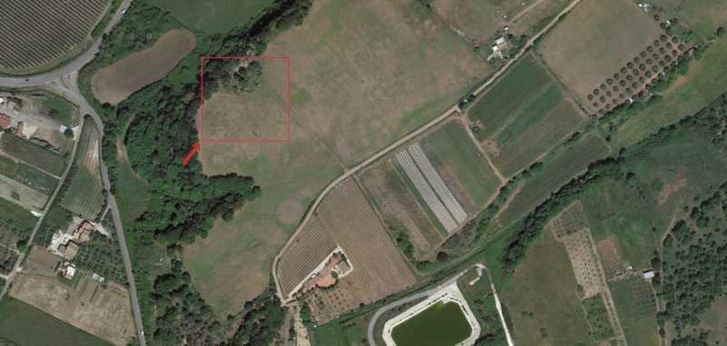
Estudio histórico-arqueológico del cerro de Palomarejo (Montoro, Córdoba). Aproximación a su paleotopografía mediante la aplicación de la Arqueología Virtual.
It is well known that interpretation always conveys a certain degree of subjectivity, which disappears as soon as interpreted data are stored in a computer database. This may lead to dangerous approximation and possibly to fallacious conclusions. To avoid this oversimplification, it has been suggested to use fuzzy databases, in which attributes may have a fuzzy nature and be indexed by a numerical coefficient, the fuzzy coefficient, which can be interpreted as the degree of confidence the researcher has in each possible assigned value. This technique has been successfully applied to gender and age assignment for the deceased in a cemetery investigation: in this case anthropological data offered statistical parameters that could be used to compute the fuzzy coefficient. Lithics classification is another field in which fuzzy databases have a potential usefulness, but in this case, no previous statistics may help in determining the fuzzy coefficient. We decided to perform an experiment during a standard typological classification of a flint tool assemblage from Israel. It concerned the classification of 50 tools, by different researchers. Each one was asked to note, besides the typology of each item, an evaluation of the 'degree of sureness', or the 'possibility' of an item to belong to a particular type, in other words his or her guessed estimate of the fuzzy coefficient. This paper reports the results of this experiment, in order to evaluate the difference between researchers when performing a classification of tools, to recognize problematic types or items (which mostly differed between the typological lists presented) and eventually to compute a fuzzy coefficient for each type assignment, balancing the different evaluations of experts.
Increasing population and needs for an augmented food supply give greater importance to improved procedures for estimating agricultural water requirements both for irrigation and for rain-fed agriculture. Four methods for estimating potential evapotranspiration are compared and evaluated. These are the Class A evaporation pan located in an irrigated pasture area, the Hargreaves equation, the Jensen-Haise eguation, and the Blaney-Criddle method. The evaporation pan is rated as superior to the other methods. However, the difference in reliability between the pan and the Hargreaves method are not considered to be very significant. Both the Jensen-Haise and the Hargreaves methods require either measured or estimated solar radiation. Methods are presented for estimating solar radiation from the difference between maximum and minimum temperature, from the percentage of possible sunshine, and from relative humidity. These procedures have some limitations, but provide improved reliability and make the estimates more universal.
An increase in walking or hiking activities in natural areas requires improvements in information and advice about trails, including their difficulty, available services and estimated travel time. Comparative studies show remarkable differences between measured and calculated travel times obtained by available predictive procedures (Naismith’s rule, Tobler’s hiking function or MIDE). A new procedure has been designed by combining pre-existing methods (Tobler’s and MIDE), and travel times have been calculated for 21 trails located in different protected natural areas of Spain. Times obtained are compared with travel times measured by individual users and uploaded into specialized walking-hiking websites (Wikiloc). Results show that the new procedure (Modified Tobler) reduces differences between calculated and measured travel times, which makes it suitable not only for trail managers to estimate travel times but also as a key part of pedestrian transport analysis in trail networks.
The paper proposes the representation of the evolution of the Comacchio Valleys between the 11th and 16th centuries CE. The bases for this representation are provided by stratigraphic, topographical, cartographic and historical-documentary data; the frame is offered by information technology. The possibility of reconstructing the physical characteristics of a landscape in a diachronic perspective with a certain degree of detail offers valuable insights not only in order to refine our knowledge on the given topic but also in view of the evaluation of the archaeological potential and planning of research.
Archaeologists have recently embraced photogrammetry as a low-cost, efficient tool for recording archaeological artifacts, active excavation contexts, and architectural remains. However, no consensus has yet been reached about standard procedures for reliable and metrically accurate photogrammetric recording. The archaeological literature describes diverse equipment and approaches to photogrammetry. The purpose of this article is to open a discussion about when and how photogrammetry should be employed in archaeology in an effort to establish “best practices” for this new method. We focus on the integration of photogrammetry within a comprehensible research plan, the selection of equipment, the appropriate apportionment of labor and time on site, and a rubric for site photography that is conducive to successful and efficient modeling. We conclude that photogrammetric modeling will soon become an indispensable tool in most archaeological applications but should always be implemented in ways that do not place undue burdens on project personnel and budgets and that aid research goals in well-defined ways.
In the early 1990s the author brought attention to the fact that the Carta Archeologica d’Italia - due to the entity of the project which involved all of the national territory and the time required for the relative research - was in urgent need of a structural updating, through an effective system of access to the results. These demands were of a nature that only a correct use of computer technologies could guarantee in real operational time. In that period, only a few advanced experimental peaks of topographic research actually included the automatic transition of information from the phase of terrain reading to that of operational planning feasibility. Since then, many scientific projects have been devoted to locating and documenting tangible and intangible cultural heritage in Italy. However, we still have to deal with the problem of adopting common platforms to share information and make use of cartographic systems in a GIS environment, regardless of the symbols being used in the documentation phase as well as in the interpretive phase. The same information can be turned from geographical points into plan details, through an automatic scale conversion and with a scientific perspective available for the requirements of different user environments. The author concludes by remarking on the urgent need of a convergence of competences from specialised sectors. Nevertheless, modern research, while taking advantage of the co-operation of a wide range of experts, should always consider that results coming from different points of observation pertain to the observers’ specific field and should not be "invasive" but respectful of their methods.
Nel presente contributo sono descritti i metodi di documentazione grafica dello scavo archeologico sperimentati nei siti di Mursia (Pantelleria, TP), Rontana (Brisighella, RA) e San Severo (loc. Classe, Ravenna). Sono illustrate, inoltre, le esperienze di rilievo architettonico effettuate presso la pieve di San Cassiano in Decimo (loc. Campiano, Ravenna) e il castello di Pianetto (Galeata, FC). Dei metodi impiegati, che si basano sulla stereofotogrammetria e sulla fotomodellazione delle evidenze stratigrafiche, si approfondiscono, in particolare, alcuni aspetti: la rapidità (del procedimento), l’accuratezza (della misura), il contenuto informativo (della registrazione) e il costo (degli strumenti). Seguono alcune soluzioni per l’integrazione di questi metodi negli attuali standard di documentazione dello scavo archeologico. Si precisano, inoltre, le possibilità d’impiego degli elaborati per la comunicazione delle interpretazioni archeologiche (il processo di posa in opera degli elementi costruttivi, la stratificazione architettonica, le diverse fasi edilizie e gli assetti architettonici ipotizzati nei diversi periodi storici).
From 2008 to 2009 the Department of Archaeology and the Department of Ancient History of the University of Bologna conducted the JiC - Jewellery in Context project. From the beginning, the JiC project pursued among its principal aims the creation and development of a database centred on the systematic census of ancient jewels, ornaments and other precious objects from the Mediterranean area, with specific attention to the context in which each artefact was found. Considering the typological variety and the different chronological, geographical and cultural ambits of provenance of the objects, the creation of an interactive web database - based on an open source server-side system - makes it possible for specialists in several distinct areas of study (Greek, Roman, Byzantine and Medieval Archaeology, Numismatics, History of Art, etc.) to cooperate with each other. In this regard and in order to preserve the specificity of the numismatic evidence in works produced by ancient goldsmiths, each form for the insertion of new records, as defined in the table Objects of the database itself, enables us to enter the description of coins mounted in jewellery. A specific set of fields contains detailed and particular connotations of each coin specimen: physical and technical data (such as metal, denomination, weight, diameter, die axis), information about the issuing authority, chronology, place of mintage, state of preservation, obverse and reverse types, references and further observations.
An overview is presented of ongoing initiatives within the frame of the Monte Abatone Project, focused on the large urban necropolis of the Etruscan city of Caere (Cerveteri). Excavation campaigns; a multi-layered GIS, suitable for archive data and new acquisitions onfield; an experimental processing and modeling of the multi-scalar Information System – architectural (BIM) and topographic (GIS) – of the Campana Tumulus; challenging restorations of thousands of sherds: all this should contribute to have a clearer picture of the necropolis and of the historical and cultural profile of the city.
Epigraphy in the Digital Age: Opportunities and Challenges in the Recording, Analysis and Dissemination of Inscriptions</i> originates from the International Conference <em>El patrimonio epigráfico en la era digital: Documentación, análisis y socialización</em> (Madrid, 20-21 June 2019), organized by the Complutense University of Madrid and the University of Santiago de Compostela. Taking the results of the conference as a starting point, the book presents epigraphic research using digital and computational tools, bringing together and comparing the outcomes of both well-established projects and newer ones, so as to establish a comprehensive view according to the most innovative trends in investigation. 21 contributions have been gathered together, involving 38 scholars, which address issues related to open-access databases, SfM Photogrammetry and Digital Image Modelling applied to textual restoration, EpiDoc (TEI-XML edition), and Linked Open Data. In this manner, the book offers a dialogue based on very different perspectives and previous experiences to generate common research questions, methodologies, practical solutions, and significant results. The outcome is intended more a starting point and platform for future research than as a definitive point of arrival in terms of so-called 'digital epigraphy'.
Entre la costa y la sierra gaditanas hay una gama de paisajes cuyos recursos naturales han sido explotados a lo largo del tiempo. El marco temporal elegido –siglo XV –es especialmente sensible al tratarse de un período donde cristalizó una nueva sociedad. Presento cuatro ejemplos significativos donde profundizo en esta problemática: el paisaje pecuario al sur del río Guadalete, el paisaje vitivinícola en Jerez de la Frontera, el paisaje olivarero en la Campiña y en la Janda y el paisaje salinero en la Bahía de Cádiz. Desde la microhistoria ambiental se reflexiona sobre la interacción de la sociedad con el medio ambiente y se pone el acento en el aprovechamiento de los recursos naturales.
The project features the creation of a webGIS containing heterogeneous data about entertainment buildings in the whole Roman Empire: stadiums, circuses, theaters, and amphitheaters. Information available in earlier studies have been integrated with more recent historical information, modern maps, and satellite data. This geo-database of the Roman structures gives access to information such as localization, name, country, if there are any archaeological remains and if the monument is still visible. The results of the presented work are useful to 1) analyze the relationship between buildings and surrounding lands, 2) perform advanced hypothesis about the accessibility to the structures or the role of these type of buildings in the urbanistic context, 3) understand relationship between entertainment and society and 4) identify concentrations of structures in certain regions. This research is mostly focused on the study of satellite images, published and historical sources. A substantial level of attention has been dedicated to the reusability and availability of the collected data.
The Soprintendenza per i Beni Archeologici di Ostia is the Italian government office charged with the preservation of the ancient Roman city of Ostia and its surroundings. Ostia has been the object of excavations since the Middle Ages and has yielded an enormous quantity of finds of all kinds. The Soprintendenza today undertakes mostly preventive excavations, especially in connection with public works. These result in vast quantities of finds that need to be housed in the office’s stores. Since 2004 the management of the stores has availed itself of the use of Radio-Frequency Identification (RFId), an automatic identification method relying on storing and remotely retrieving data using devices called RFId tags or transponders. An advanced automatic identification technology based on the RFId technology has two values for inventory systems. First, the visibility provided by this technology allows an accurate knowledge on the inventory level by eliminating the discrepancy between inventory record and physical inventory. Second, the RFId technology can prevent or reduce the sources of errors. Benefits of using RFId include the reduction of labour costs, the simplification of business processes and the reduction of inventory inaccuracies.