Despite increasing concern with the effects of archaeological data recovery methods on the types and quantity of objects extracted from the material record, archaeologists rarely discuss recovery biases attributable to the most basic excavation procedures. In this study I examine how several factors, including variable artifact identification skills, can affect artifact recovery rates in the field. Data from household-level investigations at the Stó:lō (Coast Salish) village of Welqámex (DiRi 15) are presented to show how interobserver variation can compromise interpretations of past behavior when opportunities for artifact recovery are limited to observations at the excavation unit and single-episode (field-only) sieving. Laboratory sorting of screen residue retained in 3.2-mm (one-eighth-inch) mesh sieves is shown to account for the recovery of as much as 87.5 percent of lithic artifacts and nearly 90 percent of archaeofaunal remains. Rates of artifact recovery in the field are highly variable among excavation crews working at Welqámex, and I argue that the application of correction factors is inappropriate unless the magnitude of recovery bias can be measured for specific excavation teams and particular depositional contexts. The results of this study further highlight the importance of documenting and mitigating the unintended effects of methodological decisions on archaeological assemblages. , Résumé A despecho del aumento en la preocupación con los efectos de la recuperación de datos con métodos arqueológicos en los tipos y cantidad de objetos extractados de la anotación material, arqueólogos rara vez discuten los sesgos en recuperación atribuidos a los procedimientos más básicos de excavación. En éste estudio examino cómo varios factores, incluyendo variación en las habilidades para identificar artefactos, pueden afectar la razón de artefactos recuperados en el campo. Datos de investigaciones al raso doméstico en la aldea Stó:lō (Coast Salish) de Welqámex (DiRi 15) son destacados para mostrar cómo variación en habilidad puede comprometer interpretaciones de un comportamiento pasado cuando la oportunidad para recuperar artefactos es limitada a observaciones en la unidad de excavación y un solo (campo únicamente) acontecimiento de harnero. En el laboratorio, separación de residuo retenido en cedazos de 3.2-mm (un octavo de pulgada) cuenta por la recuperación de hasta 87.5 por ciento de artefactos líticos y casi el 90 por ciento de restos de fauna arqueológicas. La razón de artefactos recuperados en el campo se ha presentado altamente variable entre equipos excavadores, y así arguyo que la aplicación de factores rectificadores es inadecuada menos que el impacto del sesgo en recuperación sea específicamente medida para equipos excavadores y los contextos particulares que producen depósitos. Los resultados de este estudio marcan adicionalmente la importancia de documentar y aminorar los efectos inadvertidamente causadas por las decisiones metodológicas en colecciones arqueológicas.
rcheoFOSS XIV 2020: Open software, hardware, processes, data and formats in archaeological research collects the proceedings of the fourteenth ArcheoFOSS international conference, held online due to the outbreak of the COVID-19 pandemic. The book gathers seventeen papers on three principal topics, the main sessions of the conference: use and application of free/libre and open-source (FLOS) tools in archaeology; creation, use and promotion of open data and open formats in archaeology; and development and customization of FLOS software and hardware solutions for cultural heritage. Forty-one scholars of very diverse age, academic affiliation and geographic location, but all actively involved in the promotion of FLOS culture, open data and open science in digital archaeology and humanities, contribute. The volume is completed by a critical analysis of the contribution of these important annual meetings to the scientific and cultural activity of the ArcheoFOSS community. The opportunity offered by the pandemic-related difficulties to widen the geographical scope of the conference has been further boosted by the decision to adopt the English language for most of the papers, with the hope that this will extend the work of the ArcheoFOSS community far beyond the Italian national borders.
This paper discusses how the use of AI (artificial intelligence) detected later prehistoric field systems provides a more reliable base for reconstructing palaeodemographic trends, using the Netherlands as a case study. Despite its long tradition of settlement excavations, models that could be used to reconstruct (changes in) prehistoric land use have been few and often relied on (insufficiently mapped) nodal data points such as settlements and barrows. We argue that prehistoric field systems of field plots beset on all sides by earthen banks—known as Celtic fields—are a more suitable (i.e. less nodal) proxy for reconstructing later prehistoric land use. For four 32.25 km2 case study areas in different geogenetic regions of the Netherlands, prehistoric land use surface areas are modelled based on conventional methods and the results are compared to the results we obtained by using AI-assisted detection of prehistoric field systems. The nationally available LiDAR data were used for automated detection. Geotiff DTM images were fed into an object detection algorithm (based on the YOLOv4 framework and trained with known Dutch sites), and resultant geospatial vectors were imported into GIS. Our analysis shows that AI-assisted detection of prehistoric embanked field systems on average leads to a factor 1.84 increase in known surface areas of Celtic fields. Modelling the numbers of occupants from this spatial coverage, yields population sizes of 37–135 persons for the case study regions (i.e. 1.15 to 4.19 p/km2). This range aligns well with previous estimates and offers a more robust and representative proxy for palaeodemographic reconstructions. Variations in land use coverage between the regions could be explained by differences in present-day land use and research intensity. Particularly the regionally different extent of forestlands and heathlands (ideal for the (a) preservation and (b) automated LiDAR detection of embanked field systems) explains minor variations between the four case study regions.
The field excavation techniques of Neolithic sites have changed during the past two decades. With these changes, data recording procedures have also changed profoundly. A method of merging excavated horizontal levels and reconstructed layers is presented here, and the respective database structures are developed. The results of the advanced finds analyses revealed the patterning of site refuse in large Neolithic pit-complexes. Finally, a proposal for a relational database is developed.
In 1986 and 1987, Oleson and a small team surveyed an area of 250 sq km around the site of al-Humayma (ancient Hawara) in Jordan's southern desert. Hawara was founded sometime in the first century BC by the Nabataean king Aretas. The flourishing settlement was occupied by a unit of Roman soldiers after AD 107, and it became the largest settlement in the Hisma desert during the Byzantine period. The Abbasid family built a manor house and mosque at Humayma in the late seventh century. In the course of the survey and excavation, the team documented 83 cisterns and other hydraulic installations, 26 km of aqueduct, portions of the Via Nova Traiana, first century Nabataean campgrounds, houses, and a shrine, one of the best preserved Roman Principate forts in the Near East, five Byzantine churches, several Byzantine houses, the qasr (large residence) of the Abbasid family and the mosque in which they plotted the overthrow of the Umayyad Caliphate. The site was more or less abandoned in 749 AD, when the Abbasids moved to their power base in Iraq. There has been only very light modern occupation, and the site has been unoccupied since about 1973. This is the second volume of a projected four volume series of reports about research on this important site. The first volume appeared in the ASOR Archaeological Reports Series in November 2010 (no. 15). The second volume reports on a Nabataean campground, which provides unique testimony to the flexible character of Nabataean settlement design, and provides a detailed information on the Nabataean necropolis, which shows parallels with those at both Petra and Hegra. The volume also includes the excavation records and analysis of five Byzantine churches, two of which lay above Nabataean structures, and three of which were modified for re-occupation in the Early Islamic period. There are also short reports on the probing of an Early Islamic structure of undetermined character, and on an important hoard of coins and jewellery found in the countryside. A number of subsidiary studies concern the human remains, botanical and faunal remains, fish bones, and molluscs found at the site in the course of the 11 seasons of excavation. The ceramics and small finds associated with the structures are analyzed, along with the many marble chancel screen fragments. The main audience will be archaeologists and students concerned with the architecture and economy of Nabataean through Abbasid period settlements in the desert Near East. The presentation highlights issues such as the projection of culture from Petra outward to peripheral settlements, transitions between nomadic pastoralist and sedentary agricultural ways of life in Arabia Petraea, design eccentricities in rural church architecture, the spread and practice of Christianity in this region, and rural architecture of the Early Islamic period. There is also discussion of the physical evidence for local desert agriculture, stock raising, hunting, the import and export of foodstuffs, and the state of human nutrition at ancient Humayma.
La ficha UR es un instrumento para documentar los procesos de Reconstrucción /Recreación Virtual. Con esta base de datos pretendemos cubrir uno de los aspectos recomendados por las Cartas de Londres y Sevilla de Arqueología Virtual como es la transparencia de las actuaciones, ofreciendo un instrumento para gestionar la documentación y normalización de los procesos de reconstrucción y recreación virtual mediante el diseño de una ficha para la confección de la base de datos.
After a brief overview on the Etruscan city of Spina, recognized as an ideal field of investi- gation for its nature of port of trade with regard to the topic of the Conference, the contribution aims to deepen the analysis of the phenomenon of cultural interaction in this urban context from various perspectives. This aspect will be investigate through distinct but interconnected ap- proaches: the Greek epigraphic and material culture, which offers the possibility of investigat- ing the mobility of people and objects, and in particular the ways of reception and elaboration between the Greek world and the Etruscan world; the analysis of the funerary ritual, through which it is possible to tackle the problem of defining ritual practices; the iconographic analysis, despite the difficulty of reaching with certainty an effective possibility of fully evaluating the phe- nomenon.
Comprehensive Coverage of the Entire Area of ClassificationResearch on the problem of classification tends to be fragmented across such areas as pattern
Résumé La société numérique, en réclamant l'opérationnalisation des terminologies à des fins de traitement de l'information, a réactualisé la terminologie wüstérienne. La dimension conceptuelle retrouve une place prépondérante qu'elle
This paper describes a Convex Hull Insertion algorithm for constructing the Delaunay triangulation and the Voronoi diagram of randomly distributed points in the Euclidean plane. The implemented program on IBM-compatible personal computers takes benefits from the partitioning of data points, topological data structures of spatial primitives, and features in C++ programming language such as dynamic memory allocation and class objects. The program can handle arbitrary collections of points, and delivers several output options to link with GIS and CAD systems. Empirical results of various sets of up to 50,000 points show that the proposed algorithm speeds up the construction of both tessellations of irregular points in expected linear time.
A survey of archaeological evidence for agrarian practices around the Mediterranean, based on a 1988 conference at the British School at Rome. Topics covered: Methods and Problems (3 papers); Romanization of the Countryside (Gualdalquivir, Middle Ebro Valley, coastal Catalonia, Sardinia, Dalmatia); Towns and Territories (Ager Tarraconensis, Bologna, Tuscania, Crete, Greece); Lowland Agrarian Structures (Catalonia, N Etruria, Ager Falernus, Piacenza, Basse-Provence); Uplands (Samnium and Arcadia, W Lucania, Basilicata, W Apulia, Methana, Greece); Conclusions. This is the first (to appear) in a new series of A4 monographs of the British School at Rome. 240p with figs. (BSR, Archaeological Monograph 2, 1991) Pb
Il volume "lo sguardo di Icaro", curato dall'istituto centrale del catalogo e della documentazione in collaborazione con il Consiglio Nazionale delle Ricerche e l'università di Lecce, ha lo scopo di illustrare le collezioni di fotografie aeree storiche dell'aerofototeca nazionale come strumento fondamentale per la conoscenza e la valorizzazione dei beni culturali attraverso le applicazioni alla ricerca e all'attività quotidiana di tutela, valorizzazione e gestione, nel settore storico, archeologico, monumentale e ambientale. L'aerofototeca è stata costituita nel 1959 per contribuire allo studio e alla tutela dei beni archeologici, architettonici e paesaggistici del territorio italiano attraverso le immagini aeree; si è progressivamente arricchita con acquisizione di coperture territoriali più o meno ampie, realizzate da enti militari (soprattutto aeronautica militare e istituto geografico militare) e società private e di imponenti fondi storici: si ricordano le collezioni di riprese aeree del territorio italiano eseguite durante il secondo conflitto mondiale dalla Raf britannica, dall'usaf statunitense e dalla luftwaffe tedesca. Nel tempo sono confluiti nelle raccolte dell'iccd i consistenti archivi di grandi società di aerofotogrammetria in dismissione, recuperando in tal modo prezioso materiale altrimenti destinato alla distruzione, e un buon numero di riprese finalizzate, realizzate da mezzi militari su richiesta di Soprintendenze ed enti di ricerca, soprattutto per usi archeologici o in occasione di gravi calamità naturali. Attualmente l'aerofototeca conserva oltre due milioni di immagini di vario formato, solo in parte catalogate, riprese essenzialmente dal 1930 agli anni '80 ed un numero minore di immagini più antiche, a partire dal 1898, riprese da pallone frenato, dirigibile, velivoli vari. Le riprese aeree, eseguite per motivi diversi legati alle attività sul territorio, più spesso con finalità militari o belliche, fotografano situazioni progressive, precisamente datate, documentando in sostanza la storia del territorio con levate replicate talvolta con continuità periodica nelle stesse zone; costituiscono perciò un contenitore di informazioni dirette ed assolutamente oggettive, utilizzabili per le analisi storiche e per molti differenti ambiti di intervento del patrimonio culturale, ma anche per analisi, la progettazione, la conservazione ed il "restauro" Del paesaggio e dell'ambiente. Al contributo della fotografia aerea all'analisi urbanistica e territoriale, da sempre largamente utilizzato, si aggiunge la finalizzazione specifica alle ricerche archeologiche, che fu in realtà il motivo principale della Costituzione dell'aerofototeca: come noto le riprese aeree, specialmente quelle precedenti l'uso intensivo dei mezzi meccanici in agricoltura, conservano spesso le tracce visibili e misurabili di strutture antiche interpretate la foto interpretazione archeologica, negli ultimi anni incrementata dalle potenzialità degli strumenti informatici, è oggi patrimonio specialistico di pochi ricercatori e funzionari, ma costituisce in realtà uno strumento di lavoro quasi indispensabile per il censimento e la catalogazione dei beni e nell'attività operativa delle Soprintendenze.
The city of Falerii Novi is situated on the lowest eastern slopes of Monti Cimini, in the volcanic area on the western side of Tiber Valley, in the district of Fabrica di Roma (VT). The ancient Roman town was founded in 241 BC, the same year of the occupation and destruction of the ancient Faliscan town of Falerii Veteres (now Civita Castellana). Recent geophysical and lidar surveys, conducted between 1998 and 2008 by S. Keay and R. Opitz, allowed the reconstruction of the ancient city plan characterized by an orthogonal grid that was organized into 69 insulae. Thanks to geophysical surveys in 2008, along with the study of aerial photographs by G. Scardozzi in 2004, it was possible to identify a large Roman domus with slightly different orientation to the northern walls of the ancient city. These data validated the information from the excavation campaigns conducted between 1821 and 1830 and between 1969 and 1975. The research aims at integrating the data from the landscape surveys in the area of Civita Castellana in 1994, which were carried out by the Soprintendenza per i Beni Archeologici dell’Etruria Meridionale, with data derived from the analysis of aerial photointerpretation. The objective was to define, with precision, new elements for the reconstruction of the ancient topography of Falerii Novi.
L'articolo presenta i risultati di nuove ricognizioni geofisiche nell'area esterna, a nord del circuito murario di Falerii Novi. I risultati, integrati con pubblicazioni su recenti da evidenze da fotografia aerea chiari, ulteriormente la sequenza dello sviluppo della città della sua fondazione nel 241 a.C. al periodo imperiale. Essi sisul contro nuovi dettagli delle necropoli e de'anfiteatro, e pongono l'entezionezione circa l'iqua terreni delle zone della città.
I risultati di una ricognizione dell'intera parte murata della città romana di Falerii Novi vengono presentati insieme a quelli di una piccola area posta al di fuori delle mura. I metodi impiegati consistono in una integrazione di rilevamento topografico, ricognizione a piedi dell'area ed estensivo uso di un gradiometro 'fluxgate'. I risultati permettono di ricostruire in dettaglio una nuova pianta della città, che viene presentata in questo articolo, insieme ad una dettagliata descrizione delle strutture messe in luce, che includono un foro di dimensioni sostanziali, un teatro ed un portico, una serie di templi e una varietà di case private. Sebbene in maniera preliminare, questi edifici vengono discussi nel loro contesto, anche in considerazione dei nuovi dati che questa ricognizione ha fornito sullo sviluppo della topografia e delle difese della città.
In this article, we present FactoMineR an R package dedicated to multivariate data analysis. The main features of this package is the possibility to take into account different types of variables (quantitative or categorical), different types of structure on the data (a partition on the variables, a hierarchy on the variables, a partition on the individuals) and finally supplementary information (supplementary individuals and variables). Moreover, the dimensions issued from the different exploratory data analyses can be automatically described by quantitative and/or categorical variables. Numerous graphics are also available with various options. Finally, a graphical user interface is implemented within the Rcmdr environment in order to propose an user friendly package.
The Oxford Handbook of Archaeological Ceramic Analysis draws together topics and methodologies essential for the socio-cultural, mineralogical, and geochemical analysis of archaeological ceramic. Ceramic is one of the most complex and ubiquitous archaeomaterials in the archaeological record: it occurs around the world and through time in almost every culture and context, from building materials and technological installations to utilitarian wares and votive figurines. For more than 100 years, archaeologists have used ceramic analysis to answer complex questions about economy, subsistence, technological innovation, social organization, and dating. The volume is structured around the themes “Research design and data analysis,” “Foundational concepts,” “Evaluating ceramic provenance,” “Investigating ceramic manufacture,” “Assessing vessel function,” and “Dating ceramic assemblages.” It provides a common vocabulary and offers practical tools and guidelines for ceramic analysis using techniques and methodologies ranging from network analysis and typology to rehydroxylation dating and inductively coupled plasma mass spectrometry. Each chapter provides the theoretical background and practical guidelines, such as cost and destructiveness of analysis, for each technique, as well as detailed case studies illustrating the application and interpretation of analytical data for answering anthropological questions.
Arid areas are often considered as places where the emergence of complex societies and economies is unlikely to happen, due to the environmental restrictions they impose on land use, food production and settlement patterns. Archaeological data collected during 30 years in the Oman peninsula are used to analyze the relationship between human societies and climate change during the Early Bronze Age (3rd millennium BC/5th millennium BP). It is suggested that establishing a direct chronological correlation between indicators of climatic change and social evolution is unrewarding and a deterministic approach irrelevant. Societies perceive climatic change and react to it according to their representations of nature and to their history. Modeling social evolution in conjunction with environmental changes by using non-linear multi-agent models is a much more fruitful way to understand the relationship between Man and climate. Résumé On considère souvent que l’émergence de sociétés et d’économies complexes est impossible dans les zones arides, du fait des restrictions qu’elles imposent à l’usage des terroirs, la production de nourriture et le type d’habitat. On utilise les données archéologiques recueillies dans la péninsule d’Oman depuis une trentaine d’années, pour analyser la relation entre sociétés humaines et changement climatique durant l’âge du Bronze ancien (3e mill. av. J.-C./5e mill. BP). La méthode qui consiste à rechercher selon une approche déterministe un synchronisme entre les indicateurs du changement climatique et l’évolution des sociétés est considérée comme peu pertinente et improductive. Les sociétés perçoivent le changement climatique et y réagissent selon leur histoire et les représentations qu’elles se font de la nature. La modélisation de l’évolution des sociétés en relation avec les changements de l’environnement à l’aide de modèles multi-agents non linéaires est proposée comme une méthode plus appropriée pour comprendre les relations entre Homme et climat.
The dissemination of the tangible and intangible values of heritage building represents one of the most important objectives in the field of Digital Cultural Heritage (DCH). In recent years, different studies and research applied to heritage monuments have shown how it is possible to improve the awareness of the architectural heritage through the integration of latest developments in the field of 3D survey, 3D modelling, Building Information Modeling (BIM) and eXtended Reality (XR). On the other hand, this digital workflow requires a huge amount of data sources and a holistic approach to reach a high level of information sharing coming from different disciplines and sectors such as restoration, geomatics, 3D virtual museums and serious gaming. In conjunction with entertainment software and gaming, this research shows the main results obtained during the generative process of digital environments oriented to improve the level of information and to enrich the contents coming from the informative models. The case study is represented by one of the most important Lombard monuments: the Basilica of Sant’Ambrogio in Milan. This study, starting from the 3D survey and the data collection of the historical records of the church, improves the creation of an XR experience that reaches a new level of interactivity for different types of devices (desktop, mobile, VR headset) and users (experts, non-experts).Highlights:Generative modelling requirements and novel grades of generations (GOG) and accuracy (GOA) are presented in order to improve the digitisation of built heritage from the 3D survey, reducing time and costs of the scan-to-BIM process.The holistic value of generative modelling allows experts to create digital worlds able to faithfully and accurately represent the detected reality and improve new immersive environments for Virtual Reality (VR) and Augmented Reality (AR) projects.Immersive environments are created with a mixture of the latest generation software and hardware, allowing users to discover the hidden historical values of built heritage with new levels of interactivity and information.
Digital reconstructions for valorization projects are becoming increasingly popular and the creation of narratives that catches the user’s attention and instigates their curiosity is the key to edutainment. However, as shown by interviews and related work, there is still a lack of a working methodology for a balanced and fruitful collaboration between academia and creative industries. Even though this work is still in its early stages, in this paper we propose a methodology for bridging the gap between academia and creative industries through the development of the Extended Matrix Narratives (EMN) tool. It allows academics and creative people to construct narratives, characters, dialogues, and scenes in a schematic way, helping to ensure that the virtual reconstruction is both accurate and engaging for the target audience. The main step is to compile a dossier documentative, a collection of all the information that may be necessary for the creation of context, setting, narrative, or characters. This document provides a solid scientific basis for the final product and helps to direct the creative team. The result is a narrative that is both accurate and engaging, and that can be used for a variety of purposes, such as education, entertainment, and cultural heritage preservation.
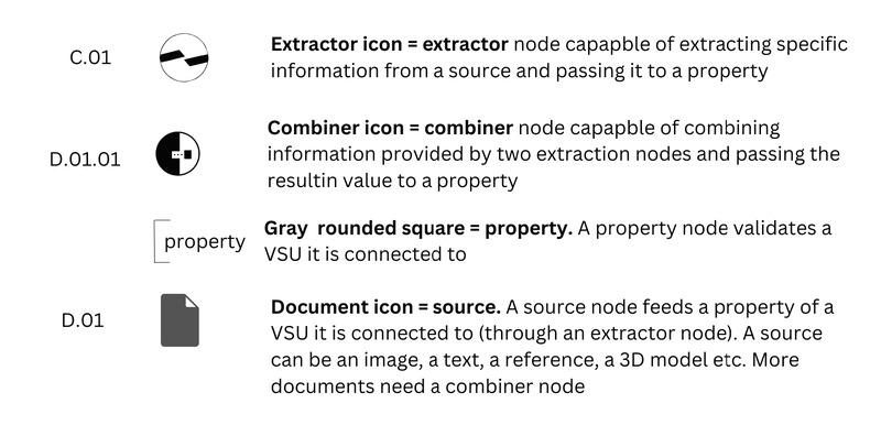
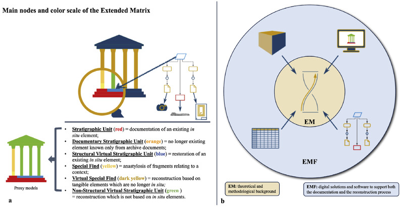
The following contribution aims at presenting a new free and open source software, EM Manager, created to assist archaeologists at approaching virtual reconstruction projects with the Extended Matrix (method developed at the Digital Heritage Innovation Lab - DHILab - of the CNR-ISPC of Rome). EM Manager is a free and open source standalone software, already available on GitHub, that allows to convert a table into an Extended Matrix. The software represents a remarkable update of the Extended Matrix Framework and, due to its features, it will expand the user base, since it helps EM users to cover one, or more, of the ‘7 key roles’ considered by the Extended Matrix method. In addition, the fact that EM Manager is Python based ensures the possibility for future implementation with other platforms (such as QGIS and Blender) based on the same language.
This project tests the hypothesis that the Langobard migration into the Roman/Byzantine Veneto (northeastern Italy) resulted in significant dietary changes from Late Antiquity (4-5th centuries AD) to the Early Medieval period (6-8th centuries AD). At the end of the Great Germanic Migrations in AD 568, Langobards from Pannonia entered and occupied two-thirds of the Italian peninsula. It is unclear how large these migrations were, as historical documents exaggerate mass movements; however, conservative estimates suggest they made up 8% of the areas they occupied. The degree to which the Langobards influenced economic change and subsistence in this area is poorly understood. Therefore, the goal of this research is to use stable isotope analyses on human remains in conjunction with historical and archaeological data to understand how the migration of the Langobards influenced the population structure and political economy (diet) in the Veneto. A total of 149 individual bone samples from seven sites spanning the 4-8th centuries AD from the Veneto underwent stable carbon and nitrogen isotope analysis. In addition, 60 premolars were sampled for stable carbon, nitrogen, and oxygen isotope analysis to assess migration and dietary changes. Previous paleodietary analyses suggest that the traditional Roman diet consisted of C3 terrestrial plants, such as wheat and barley, and domesticated animals with some contributions from fish. The Langobards consumed a mix of C3 and C4 (millet and sorghum) terrestrial plants and animals. C4 plants such as millet were often considered a low socioeconomic status food source during the Roman Empire. The results indicate that migrating Langobards are not present in the cemetery samples; however, migrating Roman/Byzantines are. This suggests a migration inland from the Byzantine occupied coast for better economic prospects. Byzantine occupied areas in Italy experienced heavy taxations, while the Langobards reduced this burden on the location populations. The dietary analyses show significant differences in diet between local and non-local individuals, with non-local individuals consuming more C3 energy sources (wheat) earlier in life. In terms of overall diet in the Veneto, there appears to be an increase in millet consumption from Late Antiquity to the Early Medieval period. There are no significant differences in socioeconomic status or sex, suggesting that millet became standardized in the Veneto, reflecting a sociocultural change in dietary practices. This research is significant because it fills a geographical and chronological gap in Italian history, during a period of significant migration and economic change.
This paper has two aims. The first is to introduce to a wider audience the recently proposed Bubble Model: a new method to reconstruct ancient settlement territories. After a preliminary discussion of similar methods that have been used in archaeology, such as Voronoi diagrams (Thiessen polygons), Multiplicatively Weighted Voronoi diagrams and XTENT, the Bubble Model is defined and its characteristics are compared. Strengths and weaknesses are identified and discussed. The main advantages of the new model are: a diachronic approach (the reconstructions of the territories depend on the order of appearance of the settlements); the possibility to detect federative polities. The second aim is to discuss the problem of contemporaneity between settlements. It is quite common to observe, in detailed regional studies, simple maps showing the increasing or decreasing number of settlements for each chronological phase. However, since we cannot be certain of the contemporaneity of all settlements, the trends over time might be biased by settlements with very short life (i.e. less than an archaeological phase). Thus, it is worthy to introduce the concept of Minimum number of Contemporary Settlements (MCS). Finally a case study from Latium Vetus and Etruria (Italy) is presented. Using both methods, it has been possible to hypothesise the presence of hierarchical polities in the Tolfa Mountains, from the Early Bronze Age to the Final Bronze Age. Whereas, in the Cerveteri area only federative polities seem to exist from EBA till FBA1-2. Moreover, it is shown that the progressive decrease in settlement number in southern Etruria might partially be due to a gradual process of stabilization of the minor villages. Since the EBA, major central settlements seem to be regularly distributed at about 100/120 minutes walking time distance, resulting in territories of 50/60 minutes radius. At least at the beginning of the EIA, the proto-urban settlements of Roma, Veii and Caere seem to almost double their territory radius.
NetworkX is a Python language package for exploration and analysis of networks and network algorithms. The core package provides data structures for representing many types of networks, or graphs, including simple graphs, directed graphs, and graphs with parallel edges and self loops. The nodes in NetworkX graphs can be any (hashable) Python object and edges can contain arbitrary data; this flexibility mades NetworkX ideal for representing networks found in many different scientific fields. In addition to the basic data structures many graph algorithms are implemented for calculating network properties and structure measures: shortest paths, betweenness centrality, clustering, and degree distribution and many more. NetworkX can read and write various graph formats for eash exchange with existing data, and provides generators for many classic graphs and popular graph models, such as the Erdoes-Renyi, Small World, and Barabasi-Albert models, are included. The ease-of-use and flexibility of the Python programming language together with connection to the SciPy tools make NetworkX a powerful tool for scientific computations. We discuss some of our recent work studying synchronization of coupled oscillators to demonstrate how NetworkX enables research in the field of computational networks.
The debate on the digital transition of cultural heritage has often focused on the opportunities and challenges faced by cultural institutions, but in recent years a growing attention has been devoted to understanding the role of grassroots and collaborative initiatives in contributing to this process. In this article, we study the Wiki Loves Monuments (WLM) contest in Italy, one of the largest and most widespread collaborative projects to document cultural heritage through open access tools. Using quantitative and qualitative evidence collected from ten editions of the initiative, the paper investigates the contribution of collaborative digital communities in the production and sharing of knowledge about cultural heritage on the Internet. In particular, our findings point out to systematic differences in the rate of documenting monuments across regions and types of municipalities, as well as peculiar patterns of the WLM community in the contribution and re-use of images in Wikimedia projects. The analysis adds insights into the opportunities and challenges that collaborative projects through open access and re-use of digital content can offer for the enhancement of cultural heritage. Il dibattito sulla transizione digitale del patrimonio culturale si è spesso concentrato sulle opportunità e le sfide affrontate dalle istituzioni culturali, ma recentemente una sempre maggiore attenzione è stata dedicata alla comprensione del ruolo delle iniziative di base e collaborative nel contribuire a questo processo. Il presente contributo studia l’esperienza italiana di Wiki Loves Monuments (WLM), uno dei più ampi e diffusi progetti collaborativi per documentare il patrimonio culturale attraverso strumenti open access. Utilizzando dati quantitativi e qualitativi raccolti in dieci edizioni del concorso, l’articolo esplora il contributo delle comunità digitali collaborative nella produzione e condivisione di conoscenza sul patrimonio culturale su Internet. In particolare, i nostri risultati evidenziano differenze sistematiche nel tasso di documentazione dei monumenti tra le regioni e i tipi di comuni, così come modelli peculiari della comunità WLM nel contributo e nel riutilizzo delle immagini nei progetti Wikimedia. L’analisi contribuisce al dibattito sulle opportunità e le sfide che le iniziative collaborative attraverso l’accesso aperto e il riutilizzo dei contenuti digitali possono offrire per la valorizzazione del patrimonio culturale.
Although aerial lidar has proven to be a powerful tool for mapping archaeological landscapes, particularly in forested regions of the world, the high costs of conventional lidar acquisition from aircraft or professional-grade drones remains a hurdle to many researchers. The recent development of ultra-compact, relatively low-cost lidar mapping systems that can be deployed on consumer-grade drones now make it feasible for archaeologists to collect their own high-resolution aerial lidar of sites and landscapes, but the efficacy of these systems remains largely untested. This paper presents results of surveys undertaken using a ultra-compact, drone-deployed lidar at archaeological sites located in three different environments: 1) tropical forests at Kealakekua Bay State Historic Park, Hawai’i, 2) piñon-juniper forest on Mesa Verde’s North Escarpment, Colorado, and 3) mixed deciduous-evergreen forest at Enfield Shaker Village, New Hampshire. Results reveal a wealth of archaeological features at the three study sites and demonstrate the potential of drone-based lidar as a tool in archaeological prospection, but also illustrate some of the significant technical and practical challenges involved in making use of this exciting emerging technology.