This paper focuses on the detection and spatial characterization of microtopographic relief linked to archaeological remains using full-waveform (FW) Airborne Laser Scanning (ALS). ALS is an optical measurement technique for obtaining high-precision information on the Earth's surface including basic terrain mapping, such as Digital Terrain Model (DTM) and Digital Surface Model (DSM). In the field of cultural heritage management, ALS can provide detailed information useful for feature extraction, but the detection of archaeological microtopographic relief is still a challenge especially for vegetated and highly sloped areas. The investigation was carried out for the archaeological area of Monte Irsi (Southern Italy) characterized by dense herbaceous cover and complex topographical and morphological features, which make air/space prospection very difficult. Results from our investigations pointed out that ALS is a valuable data source to detect and map cultural features even under dense vegetation.
This paper deals with an advanced microwave tomographic approach capable of providing full 3D images of buried targets from scattered field data gathered by means of Ground Penetrating Radar (GPR) systems. The approach is based on an approximated model of the scattering phenomenon and it is capable of accounting for the vectorial nature of the interactions occurring between electromagnetic waves and probed materials. Moreover, the Truncated Singular Value Decomposition inversion scheme is exploited to solve the involved linear inverse scattering problem in a stable and accurate way. The advantages offered by the full 3D inversion algorithm with respect to a commonly adopted strategy, which produces 3D images by interpolating 2D reconstructions, are assessed against GPR data gathered in laboratory controlled conditions. Moreover, to provide an example of the full 3D imaging capabilities in on field conditions, we report on a GPR measurement campaign carried out at Grotte dell’Angelo, Pertosa, (SA), Southern Italy, one of the most famous sites of the Cilento and Vallo di Diano geopark.
Il Progetto MARTA Racconta. Storie virtuali di tesori nascosti è nato con l’obiettivo precipuo di rendere ‘accessibili’ e fruibili nel Museo Nazionale archeologico di Taranto (Marta), attraverso un’installazione di realtà Virtuale, alcuni monumenti
Nel dibattito sulla ricerca di nuove metodologie archeologiche, ha cominciato a svilupparsi, nell’ultimo decennio, l’utilizzo dei BIM (Building Information Modelling). Tale tecnica, derivata da discipline quali l’architettura e l’ingegneria civile, prevede la realizzazione di modelli 3D di oggetti architettonici correlati a una serie di database, consentendo la gestione simultanea di una grande mole di dati eterogenei.
In order to improve the framework for 3D modeling, a great challenge is to obtain the suitability of Building Information Model (BIM) platform for historical architecture. A specific challenge in HBIM is to guarantee appropriateness of geometrical accuracy. The present work demonstrates the feasibility of a whole HBIM approach for complex architectural shapes, starting from TLS point clouds. A novelty of our method is to work in a 3D environment throughout the process and to develop semantics during the construction phase. This last feature of HBIM was analyzed in the present work verifying the studied ontologies, enabling the data enrichment of the model with non-geometrical information, such as historical notes, decay or deformation evidence, decorative elements etc. The case study is the Church of Santa Maria at Portonovo, an abbey from the Romanesque period. Irregular or complex historical architecture, such as Romanesque, needs the construction of shared libraries starting from the survey of its already existing elements. This is another key aspect in delivering Building Information Modeling standards. In particular, we focus on the quality assessment of the obtained model, using an open-source sw and the point cloud as reference. The proposed work shows how it is possible to develop a high quality 3D model semantic-aware, capable of connecting geometrical-historical survey with descriptive thematic databases. In this way, a centralized HBIM will serve as comprehensive dataset of information about all disciplines, particularly for restoration and conservation. Moreover, the geometric accuracy will ensure also reliable visualization outputs.
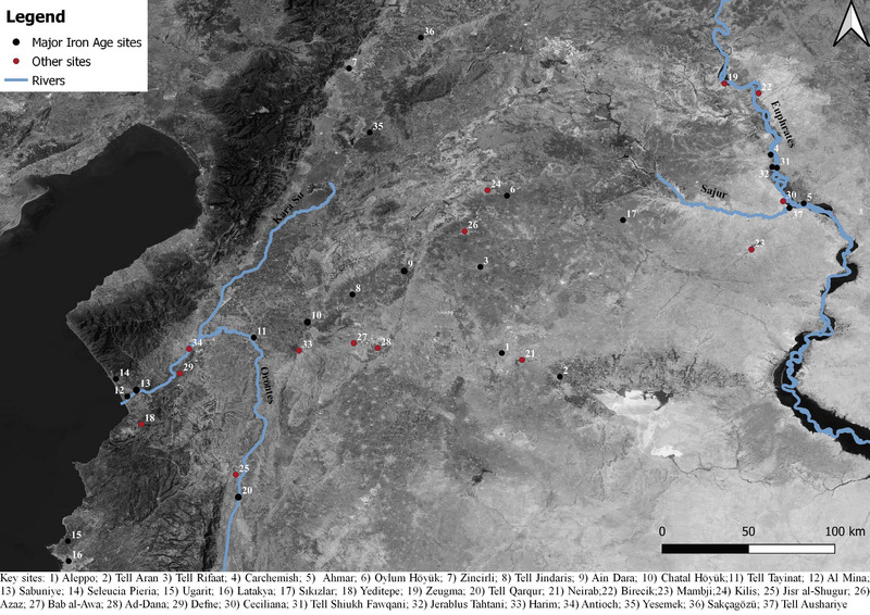
The study of ancient roads has been important in understanding political, social, and cultural transformations of ancient trade networks and economies. In the Near East, landscape-oriented research has immensely contributed to the analysis of pre-modern road systems. However, while for Roman and medieval periods this method produced a dataset that implemented the rich corpus of historical information, research on pre-Roman connectivity networks strongly relies on the archaeological record, mostly represented by data from surveys. The use of these data allows a long term and chronologically unprecise reconstruction of ancient itineraries. Therefore, gaps in the data are often filled by the transposition of later itineraries, risking reiterating the idea that road networks are static, stable over a very long period. This article aims to contextualise connecting networks and route landscapes from the Euphrates river to the Mediterranean sea during the Iron Age (1200-600 BCE). The study will make use of an integrated approach by using multiple datasets. The research will argue that by considering different data, it is possible to offer a critical interpretation of the main route network employed during the Iron Age to connect the Euphrates area with the sea.
This paper deals with the results of an experiment that was conducted as part of the CNR Project entitled Iraq Virtual Museum, the goal of which is the construction of a Virtual Museum that will allow the public to enjoy the main archaeological treasures of the ancient civilizations that flourished in the territory of modern-day Iraq. The work was aimed at the contextualization of the ancient objects in the territory of origin. This result was achieved by recourse to image-based technologies and remote sensing. In the exemplary case of the city of Ur, the process of contextualization began with the modelling of the golden helmet of king Meskalamdug, and continued with the reconstruction of the tomb in which it had originally been placed, together with the rest of the funerary objects. This tomb was then contextualized within the Royal Cemetery and the urban layout of Ur. High resolution satellite images made it possible to observe and document the archaeological area as it is today, for a virtual visit and in preparation for a potential real visit in the future. Furthermore, research activities have made it possible to acquire new knowledge of the objects, the monuments, the urban layout and the historical landscape.
The multilingual thesaurus TheA (Thésaurus-Antiquité), by the French team of the LIMC, is dedicated to classical mythology and monuments. Vocabularies now regarded as a key component in semantic web provide new opportunities to increase data interoperability. Although considered and used as a tool closely related to the online LIMC-France resources, TheA is in a process of transfer into a SKOS- and ISO25964-compliant online application allowing access to its content and alignments with reference thesauri. TheA or some of its components could be used in the Linked Data and in processes to improve data quality
The area of Castronovo di Sicilia was analysed by integrating different methodologies. In terms of the road network, it was decided to compare information from traditional written sources, such as the Itinerarium Antonini and texts from the Arab geographer al-Idrisi, with the results of the Least-Cost Path Analysis (LCPA) conducted using the QGIS plugin ‘movecost’. The primary objective of this analysis was to evaluate how the centrality of the Castronovo area was determined by environmental factors that made it easily accessible along the main long-distance routes connecting the island. At the same time, the analysis aimed to highlight similarities and differences between the written sources and the LCPA results.
The Office for the Archaeological Map of Italy was established by Royal Decree in 1889. In 1926, as an ideal continuation of the Archaeological Map, the first volume of the Forma Italiae was published. Subsequently, with the advent of information technology, a new era of archaeological mapping began, adjusting the Forma Italiae to the latest technological developments. Inheriting this solid methodological basis, and benefitting from the latest digital innovations, we present the Sardinian node of the national archaeological computer network. This is not the proposal for the creation of yet another archaeological information system, but a project for the creation of a tool aimed at data sharing and identification of archaeological heritage property. The project intends to be a point of reference for data exchange on a national and international scale and at different levels of detail.
The first diachronic investigation of wool fibre from Italian pre-Roman archeological contexts was carried out using scanning electron microscopy (SEM). A total of 22 archaeological wool samples from 10 Italian and one Austrian site dating from the Middle Bronze Age to the Roman period were analysed. The results demonstrate the processing of wool and development of sheep fleece from primitive wool with very fine underwool and very coarse kemps to the disappearance of kemp and coarser but more uniform fleece. By the end of the Iron Age several fleece qualities coexisted in Italy, possibly indicating the presence of different breeds. Classification of the wool qualities based on existing systems was problematic leading to a conclusion that a more nuanced approach to the classification of archaeological material is needed.
3D recording methodologies have been successfully integrated into the archaeological fieldwork practice, resulting in a widely accepted series of advantages for the documentation of the excavation. However, post-processing analysis is often neglected and recording protocols do not consider possible developments for exploiting the potential of 3D data. At the excavation of Vetricella, in Italy, the ERC nEU-Med project developed a digital documentation protocol aimed at reconstructing the volumetric physical space occupied by each stratigraphic unit, generating more than a thousand contexts over the course of four archaeological seasons. In this contribution we are going to present how the volumetric approach has influenced the whole methodology of documentation since the recording stage, introducing a standardized workflow aimed at reconstructing solid geometries from 3D surfaces. In this protocol a great attention is paid to the strategies, timings and needs of the fieldwork practice, without overlooking important archaeological aspects such as data accuracy and the chance to generate data for more quick on-field interpretation. The final outcome is a new visualization and analysis of the space with the use of volumetric models, which results in greater accuracy in displaying physical and stratigraphic relationships, as well as generating volumetric quantitative data. In the end, some examples drawn from Vetricella will be employed to show how solid 3D geometries and volumetric quantities can be used in support of the archaeological interpretation of the site.
This paper traces the development of techniques of recording carvings on megalithic tombs and on open-air rock-art in Ireland from 1699 to the present day. Analysis shows that after the initial pioneering phase, recording methodologies tended to develop in accelerated bursts, interspersed with lulls in activity. In all, four phases of activity can be identified; in each there were a critical number of researchers who interacted with each other, driving forward advances in various forms of recording methods. Part 2 of the paper describes the application of new methods of digital recording, notably Structure from Motion photogrammetry. It shows how the resulting data have been used to create new ways of experiencing Irish prehistoric art in virtual environments, either as entire monuments in the landscape or within a “virtual museum”, using the open-source Blender 3D animation and game engine software.
Human belief systems and practices can be traced to ca. 10,000 BCE in the Ancient Near East, where the earliest evidence of ritual structures and objects can be found. Religious architecture, the relics of human skeletons, animal symbolism, statues, and icons all contributed to a complex network into which the spiritual essence of the divine was materially present. In this book, Nicola Laneri traces the transformation of the belief systems that shaped life in ancient Near Eastern communities, from prehistoric times until the advent of religious monotheism in the Levant during the first millennium BCE. Considering a range of evidence, from stone ceremonial enclosures, such as as Göbleki Tepe, to the construction of the first temples and icons of Mesopotamian polytheistic beliefs, to the Temple of Jerusalem, the iconic center of Israelite monotheism, Laneri offers new insights into the symbolic value embodied in the religious materiality produced in the ancient Near East.
The aim of this paper is to highlight the main benefits of using the Qfield app in archaeological jobs. In particular this article provides examples to use Qfield in open area excavation, Archaeological survey and impact assessment (HIA) projects.
The town of Catania, located in the southern part of the Sicily region, Italy, holds the remains of an ancient settlement in the city centre. One of the most important buildings is the Cathedral and the buried Achillean Baths. The Cathedral was repeatedly destroyed and rebuilt after the earthquakes and volcanic eruptions that occurred over time. The first building dates back to the period 1078-1093 and was built on the ruins of the Roman Achillean Baths, on the initiative of Count Roger, acquiring all the characteristics of an equipped (i.e. fortified) ecclesia. Already in 1169, a catastrophic earthquake demolished it almost completely, leaving intact only the apse. In 1194 a fire created considerable damage and finally in 1693 the earthquake that hit the Val di Noto destroyed it almost completely. The area around the Cathedral is today highly urbanized, but it was the locus of social and political life over the centuries for people of different cultures who have inhabited the area since the 8th century BC. Therefore, this area contains stratigraphically complex layers of buildings and other remains, which can help understand the use of this area of the town over many centuries. A ground-penetrating radar and electrical resistivity tomography surveys were performed inside and outside the Cathedral of Catania. Data were visualized in three-dimensions using a standard amplitude slice technique as well as the construction of isosurface images of amplitudes. These images reveal the position of architectural features whose shape, size and burial depth suggest they are Roman and earlier in age. The features mapped overlap the development of the Achillean Baths and the presence of some tombs and unknown rooms
In this paper we address all the problems and solutions of converting a measured point cloud into a realistic 3D polygonal model thatcan satisfy high modeling and visualization demands. Close range photogrammetry deals since many years with manual or automaticimage measurements. Now 3D scanners are also becoming a standard source for input data in many application areas, providing formillions of points. As a consequence, the problem of generating high quality polygonal meshes of objects from unorganized pointclouds is receiving more and more attention. After reviewing the different 3D shape techniques for surface reconstruction, we willreport the full process of converting a usually unstructured point cloud into a consistent polygonal model. Some triangulationalgorithms, modeling methods and visualization techniques are also described and different examples are presented.
The assessment of the structural behavior of historic masonry structures like Gothic cathedrals is an important engineering and architectural issue, because of the economic and cultural relevance of such buildings. In this article, we present a complete numerical methodology for point clouds processing, geometrical and parametric 3D modeling, and finite element structural analysis of the spire of the Cathedral of Senlis, France. Our work highlights the particular difficulties linked with digitization and geometrical modeling of highly complex Gothic structures, as well as the need to find compromises between quality and accuracy of extracted data used for geometrical modeling and structural analysis. The methodology enables the semi-automatic transformation of a three-dimensional points cloud, surveyed through terrestrial laser scanner, into a three-dimensional geometrical historic building information modeling (hBIM)-oriented model, and its use to propose a consistent 3D finite element mesh suitable for advanced structural analysis. A full software chain is integrated in the proposed numerical process, so as to use the most important data contained in the real geometry and accurately transposed in the point clouds. After a successful data processing step with 3DReshaper software that proved to be necessary for enhancement of point clouds, a semi-automated geometrical hBIM-oriented modeling step with Rhinoceros5 software and VisualARQ plugin has allowed the construction of a hybrid model by reverse engineering from the point clouds. This 3D model, containing both geometrical and parametric data of the structure, has been exported to the Hyperworks suite for finite element structural analysis under self-weight. Our computations focused on the estimation of the structure deformation and on the distribution of compression and traction stresses in all components of the complex structure. It is found that the spire is safe. Based on reliable and properly detailed results, our study provides significant information for understanding the behavior of the structure and potential damage monitoring.
In this article the authors present a method for obtaining a line-art representation of a mural painting using colour photography. First, the information concerning colour components was separated and then the contours of graphic representations were extracted. The result is an exact copy of the original and this level of precision makes it an important solution to the problem of registering and recording mural paintings. This method has been shown to be a useful solution for the documentation of the state of conservation of paintings, as well as a means for keeping track of restoration work; furthermore, it provides a fundamental method for analysing paint compositions. The approach was developed bearing in mind the possibility of use by non-specialist computer users: no programming knowledge is assumed and the use of shareware software was always preferred.
Mountain landscapes were first exploited by farming populations at the very beginning of the Neolithic. However, there are controversies regarding when and where these specific types of human behaviour developed as a result of adaptation processes to these special environments. The aim of People in the Mountains: Current Approaches to the Archaeology of Mountainous Landscapes is to present research results from different scientific contexts. To discuss these issues, and to study different aspects of human activity in the mountains and adjacent regions we incorporate archaeological, botanical, zooarchaeological and ethnological information. The chapters explore, among many other themes, several principal areas of research: environmental history and human impact in mountain environments; specificities of different mountain landscape zones; long-term changes of human activity in different mountain regions, and the origins of such changes; seasonal herding, and short and long-distance transhumance; exploitation of different raw materials e.g. siliceous raw material, salt etc.; mountains as borders, roads and zones of contact; creation of new customs, rights and social relations; symbolic and ritual locations in the mountains; dialogue between different methodological perspectives and analytical methods. The book consists of 15 chapters prepared by 27 authors from 10 countries. The chapter topics cover mountains located in Europe, America and Asia.
Over the past decade, we have witnessed an increase in the use of technology, through the creation of virtual itineraries and exhibitions, as a tool to guarantee and increase the usability of museums and more generally of artistic and historical works. In fact, it often happens that many works of art and artefacts of archaeological and cultural importance are not accessible to the public, either because they are kept in museum deposits or because they are difficult to access. In a context such as the current one, however, with an ongoing pandemic that forces most of the population to remain at home, the virtualization of museums, and historical and cultural heritage, becomes the main tool for exploring and enhancing culture. Among the various methodologies used for the creation of three-dimensional models, photogrammetry stands out for ease of use and low cost. This article analyses the use of photogrammetry in 3D modelling, focusing on pros and cons as a rapid, low-cost tool, which makes artworks virtually accessible to the public via museum websites and social network forums.
During the Upper Palaeolithic, Southern Tuscany was strongly affected by geomorphological changes that significantly altered its coastal seaboard. In particular, during the Last Glacial Maximum, the sea reached a level below 100 meters. As a result of this, the prehistoric coastland included also the present Tuscan Archipelago, in particular the Islands of Elba and Pianosa, assuming a different layout during MIS3 and MIS2. In this context, the process of prehistoric occupation took place, according to different needs and criteria. The present work explores the possibility of investigating the dynamic relationship between the prehistoric landscape and waterscape by a predictive-postdictive approach. Alongside the simulation of coastal changes, the study makes use of legacy data, taking into account those derived from artefact surface scatters collected over the past decades by various research groups. The latter provide further evidence of the prehistoric occupation process. In this scenario it is crucial to highlight areas that potentially still retain some relict features of the Palaeolithic landscape. These are examined in order to better understand settlement strategies taking place during the Upper Palaeolithic and, at the same time, to investigate the relationship between inland and coastal sites in a diachronic perspective. Although still ongoing, preliminary results provide new elements for the planning of future field surveys.
The appearance of computers as super-brain inspires the hope that archaeology will solve the problem of the multidimensional data presentation. Since 1970s, the international conferences on the computer application in archaeology have discussed the advantages of new technologies. During one of them in 1990, the term virtual archaeology was introduced for the first time by Paul Reilly. He discussed both possibilities: visualizing in the computer screen the total amount of data obtained from the fieldwork and using the technologies applied in the computer games production for scientific aims. The word visualization also became the keyword of the definition given 20 years later in the International Charter on Virtual Аrchaeology. However, in 2007, this interpretation was exposed to critic. Virtual archaeology aims at the application of computer technologies for the creation of high-quality images of archaeological objects as well as in assistance to the archaeological studies. Time has gone; many applied sciences introduced computer technologies, and the possibility to unify and accumulate, to analyse and to demonstrate data appeared. Today, any big scientific research of the archaeological monument supposes the application of natural sciences and computer technologies. The archaeological excavations and virtual archaeology are parts of one infinite process, and the virtual archaeology means all the newest kinds of computer technologies used for archaeological investigations, data processing, modeling, archaeological and historical reconstruction and evident representation of their results. Since the time of Paul Reilly’s definition, the meaning of the term virtual transformed from imaginary to existing in our understanding. It looks curious, but maybe very soon, instead of virtual archaeology, it will be possible to say up-today archaeology.
Hybridity and hybridization have recently become buzzwords in archaeological studies. In particular archaeologists working in the Mediterranean on Bronze Age networks of interaction (e.g. Feldman 2006; Knapp 2008, 2009, 2012; Steel 2002; Voskos and Knapp 2008), on Early Iron Age colonization (Antonaccio 2003, 2010; Dietler 2010; van Dommelen 2006; Hodos 2010; Vives-Ferrándiz Sánchez 2005, 2007, 2008) and on Romanization (van Dommelen and Terrenato 2007; Hodos 2006; Webster 2001) have found it a highly useful term to describe archaeological phenomena. Whereas Bhabha (2007) defined hybridity as a strategy of the suppressed and subaltern against their suppressors in a colonial context, archaeologists particularly perceive those objects as 'hybrid' which seem to resist classification within predefined taxonomies.
Dal 2011 La MAIKI opera nei governatorati di Erbil e Sulaimaniya, e focalizza le sue attività sulla Cittadella di Erbil e sul sito di Paikuli. Gli studi storico-archeologici sui siti sono stati affiancati da importanti attività di documentazione e gestione dei dati caratterizzate dall’utilizzo di alcune tra le più moderne risorse a disposizione
Among the studies recently promoted by the University of Bologna on the Picenian necropolis of Numana (Sirolo-Numana, AN), a two-year research project has been dedicated to the application of digital archaeology techniques on a topographically consistent lot of tombs in the Davanzali area. Thanks to the financing of the University program ‘Almaidea’, a team coordinated by the author focused on the virtual reconstruction of the necropolis, in all its aspects: from the finds to the funerary landscape. This contribution presents a synthesis of the research and introduces the articles written by the members of the team (A. Gaucci, E. Zampieri, M. Silani, S. Garagnani). The different contributions illustrate the project goals, methods and results. The conclusion of this article highlights the research potential for both the study (especially for pottery) and the context valorization.
This article is framed into the theoretical and methodological background of virtual archaeology. The advantages of virtual archaeology and its weak points have long been discussed in academia, formulating theoretical foundations and principles to be followed in order to guarantee scientific results, where data are traceable, transparent and verifiable. Gathering the inheritance of the last 30 years of debates and research, this work proposes implementing these principles through the formulation of a methodological approach, to virtual reconstruction of archaeological contexts, consisting of an application protocol articulated in five steps. In particular, the proposed methodology is grounded in the Extended Matrix (EM), a formal language and tools entirely developed and tested by the Virtual Heritage lab of the CNR ISPC. The EM takes its cue from the Matrix of Harris and adapts its system to the specific needs arising in the fields of virtual reconstruction and scientific visualisation. This protocol, which ranges from fieldwork to the publication of scientific data, has been tested and systematised in over ten years of activity on various complex and significant archaeological contexts. In the article, each methodological step is supported by case studies described in detail and accompanied by a graphic apparatus that clearly illustrates the results obtained. These case studies led to the definition of version 1.2 of the EM as described in the methods section.
The ArchéoDATA Archaeological Information System has been under development for some ten years and during this time considerable experience has been gained in the field of archaeological information management. At the outset, a methodological philosophy was established and based on the premise that archaeology was in essence something, somewhere, at sometime. This provided the fundamental platform for data recording and has also given rise to, through the development of the “Entities”, a singular framework for archaeological analysis. The structures necessary to achieve an efficient balance between research, administration and conservation have been worked out and then tested under the actual conditions that will prevail under normal working conditions. The problem has been that at the heart of an AIS is communication, and that the practical means of achieving this are not simple. Not only do we need to efficiently structure the theoretical model, there also has to be the physical means of achieving it. This has been for many years the Achilles heal of implementation, as cost has been seen as being of an order not commensurate with archaeological budgets. The unforeseen evolution of the Internet network into the World Wide multimedia Web has provided information based systems with vast possibilities, and in the case of archaeology, with its first opportunity towards implementing universal communication. This paper describes some of the steps being undertaken to transfer the ArchéoDATA AIS to the Internet.
Stratigraphic archaeological excavations demand high-resolution documentation techniques for 3D recording. Today, this is typically accomplished using total stations or terrestrial laser scanners. This paper demonstrates the potential of another technique that is low-cost and easy to execute. It takes advantage of software using Structure from Motion (SfM) algorithms, which are known for their ability to reconstruct camera pose and threedimensional scene geometry (rendered as a sparse point cloud) from a series of overlapping photographs captured by a camera moving around the scene. When complemented by stereo matching algorithms, detailed 3D surface models can be built from such relatively oriented photo collections in a fully automated way. The absolute orientation of the model can be derived by the manual measurement of control points. The approach is extremely flexible and appropriate to deal with a wide variety of imagery, because this computer vision approach can also work with imagery resulting from a randomly moving camera (i.e. uncontrolled conditions) and calibrated optics are not a prerequisite. For a few years, these algorithms are embedded in several free and low-cost software packages. This paper will outline how such a program can be applied to map archaeological excavations in a very fast and uncomplicated way, using imagery shot with a standard compact digital camera (even if the ima ges were not taken for this purpose). Archived data from previous excavations of VIAS-University of Vienna has been chosen and the derived digital surface models and orthophotos have been examined for their usefulness for archaeological applications. The a bsolute georeferencing of the resulting surface models was performed with the manual identification of fourteen control points. In order to express the positional accuracy of the generated 3D surface models, the NSSDA guidelines were applied. Simultaneously acquired terrestrial laser scanning data – which had been processed in our standard workflow – was used to independently check the results. The vertical accuracy of the surface models generated by SfM was found to be within 0.04 m at the 95 % confidence interval, whereas several visual assessments proved a very high horizontal positional accuracy as well.
The Danish industrialist and brewer Carl Jacobsen (1842-1914) became interested in Etruscan culture through his long collaboration with the German archaeologist Wolfgang Helbig (1839-1915), and he made it his project to introduce the Etruscans to the Danish public in what he named The Helbig Museum. As the unique Etruscan tomb paintings were quickly deteriorating, Jacobsen decided to sponsor a complete series of facsimiles of all Etruscan paintings. In this he followed the example of King Ludwig I of Bavaria, from whom he also took the name Glyptotek for his museum, the Ny Carlsberg Glyptotek. Helbig collected a group of painters and managed the work in Etruria while Jacobsen paid the expenses in Copenhagen. The project lasted from 1895 to 1913 and comprised sketches, tracings and facsimiles of all the then known painted tombs in Tarquinia, Chiusi, Veji, and Orvieto.
Since the 1970s, the development of archaeological databases has characterised the history of archaeological computing. The paper presents a summary of the pivotal early projects, with a particular focus on Italy and France, up to the current projects shared online. They are constantly monitored by the international journal Archeologia e Calcolatori, that since 1990 is an observatory of theoretical and methodological aspects of computing and information technology applied to archaeology.
This short paper describes the key elements of the European project IPERION CH (2015-19), which is the sequel to the Labs TECH, Eu-ARTECH and CHARISMA projects. It also outlines the creation of a long-term programme called E-RIHS (the European Research Infrastructure for Heritage Science). Listed on the ESFRI (European Strategy Forum on Research Infrastructures) Forum Roadmap, it will see the day in 2021 and will widen the field of research to natural history collections.
Writing is frequently analyzed as a mode of communication. But writing can be done for personal reasons, to remind oneself of things to do, of thoughts, of events. The cellphone has revealed this shift, commencing as a communication device and ending up as a memory prosthesis that records what we see, hear, read and think. The recordings are not necessarily for communicating a message to others, but sometimes just for oneself. Today, when machine learning algorithms read, write and transmit, a new mode of communication arises that is not centered on the human. In this chapter the various phases of modern writing are modeled according to postphenomenology. As a branch of philosophy of technology, postphenomenology offers a set of analytical tools to study technologies and our relations to them. One of its central frameworks is the scheme of “I–technology–world.” The author proposes some modifications so that the scheme can systematically model the changes in the humans users, in machine learning algorithms imbued with non-human cognition and in the environments of readers, interlocutors and contexts.
Da alcuni decenni gli archeologi creano direttamente planimetrie digitali in CAD o GIS. Questo approccio ha rivoluzionato la registrazione dei dati spaziali. Anche se le mappe registrate in CAD o GIS condividono una modalità comune di rappresentazione numerica organizzata in strati, la differenza tra i due sistemi risiede nell’associazione tra la geometria e le informazioni alfanumeriche a essa collegate e nella topologia. Pertanto, il riutilizzo dei dati CAD nei GIS non è un compito facile senza una riorganizzazione delle informazioni basata sulla costruzione di oggetti semantici, corrispondenti alle caratteristiche archeologiche reali. Molti strumenti sono stati sviluppati con l’obiettivo di convertire automaticamente i file CAD in formati GIS; ma, nonostante gli sforzi, i risultati fin qui ottenuti sono scarsamente significativi e la sfida è ancora aperta. Senza l’intervento diretto del ricercatore, questo passaggio rischia di generare dati incongruenti. Partendo da queste premesse, l’articolo esamina l’approccio seguito per organizzare e convertire le risorse cartografiche relative al sito di al-Balīd nel Sultanato dell’Oman. L’obiettivo è fornire una cornice metodologica per ancorare le strutture archeologiche esistenti e proporre un flusso di lavoro in grado di convertire i disegni CAD in file GIS.
Research in theoretical and computer-based archaeology, from the 1950s onwards, established important perspectives for the formal representation and analysis of tangible cultural entities such as complex artefacts, iconographic compositions and archaeological assemblages, and became a precursor for the emergence of knowledge-based tools, methodologies and standards for artefact-centred information systems in contemporary museums. One particular case in point is CLIO, a semantic information system intended for research use, developed by ICS/FORTH and the Benaki Museum in Greece in the early 1990s, which became a foundation for the definition of the Conceptual Reference Model of the International Documentation Committee of ICOM (CIDOC CRM), recently adopted as the ISO standard for cultural information representation. It is argued here that, as the capabilities of computer applications to provide access to complex, multimedia cultural information increase, so does also the validity and importance of earlier research advances in artefact-centred archaeological computing; and, conversely, that the advent of digital infrastructures for material culture disciplines such as archaeology highlights the pertinence, and potential benefits, of further work on archaeological formal analysis and knowledge representation.
The project ‘Masgaba. An Archaeological Map for the Island of Capri’ was launched with the aim of updating and integrating Capri’s archaeological documentation, filling the existing gaps in the knowledge of its archaeological heritage using advanced technologies. The methodological approach included new surveys and analyses of sites that required updates in the graphical documentation or had previously been misinterpreted, the analysis of archival sources to recover information on no longer visible archaeological heritage, and the documentation of museum finds that helped improve the understanding of the island’s ancient history. A central element of the project is the creation of a WebGIS, which organizes the data into an interactive digital map, providing an overall view of the island’s archaeological heritage. The web application allows users to consult detailed records, multimedia content, archival documents, and publications produced within the project. The adoption of open-source technologies has ensured the sustainability of the system, paving the way for future extensions and the possibility of integrating new data.
This paper reviews the importance of standards in archaeological computing and traces their development, and the tensions surrounding their deployment. Three categories of standards are defined: technical, content and metadata standards. Standards are shown to be particularly important to current initiatives which seek to achieve interoperability between distributed electronic resources. If we are to achieve the potential advantages of a Semantic Web for heritage data over traditional search engine technologies, standards are essential. The paper introduces the Archaeotools project, which is seeking to create a faceted browse interface to archaeological resources. It concludes that data standards and ontologies are essential to the success of such projects.
In 1997, within the framework of the research activity carried out by the Istituto per l'Archeologia Etrusco-Italica, a census of GIS applications in archaeology was promoted and then published in the ninth issue of the journal 'Archeologia e Calcolatori'. This international survey allowed us to collect significant methodological and technical information useful to outline the main guidelines of the 'Caere Project', aimed at the establishment of an Archaeological Information System for the analysis of the Etruscan town and its surrounding territory. A recent update of this survey confirmed the previsions published four years ago by the members of an international Scientific Committee coordinated by François Djindjian. Some methodological aspects of the 'Caere Project' are also discussed, with particular emphasis on the need of integrating many different computer techniques in order to gain a comprehensive, organic knowledge of the ancient landscape and town organisation. The results of the innovative use of markup languages and multimedia systems in the processing of archaeological excavation data are also presented. In fact, the methodological approach of the 'Caere Project' is based on the principle that information is not sufficient if not linked by new forms of knowledge representation, which can promote an interactive consultation more than just a passive reading.
3D modeling in rock art studies involves different techniques according to the size and morphology of the subject. It has mainly been used for reconstructing the volume of caves, morphology of walls and as a substitute to graphic and photographic recording of the prehistoric pictures. Little work has been done at macroscopic and microscopic scale, partly because lasergrammetry, which is the most common technique, is poorly adequate under the centimetric scale, while for patrimonial purposes recording at high resolution was of little interest. Thanks to the increasing performance of personal computers new modeling techniques are becoming available, based on photographic recording and no longer depending on costly and cumbersome equipments. We have tested in open air and underground sites in France, Portugal and Russia, the potential of photogrammetry and focus stacking for 3D recording of millimetric and submillimetric details of prehistoric petroglyphs and paintings, along with original simple optical solutions.
Semantic Scholar extracted view of "Free and Open Source Software Development in Archaeology. Two interrelated case studies: gvSIG CE and Survey2GIS" by D. Bibby