La colonia romana, fondata dai veterani di Scipione l’Africano sulle sponde del lago di Patria, rinasce grazie alla realtà aumentata immersiva. Un modello di ricostruzione del sito archeologico dell’antica colonia romana di Liternum – attraverso l’utilizzo combinato di software BIM (Edificius) e le piattaforme collaborative (usBIM.platform) – è stato di recente presentato a Roma durante […]
Reproducibility is the hallmark of good science. Maintaining a high degree of transparency in scientific reporting is essential not just for gaining trust and credibility within the scientific community but also for facilitating the development of new ideas. Sharing data and computer code associated with publications is becoming increasingly common, motivated partly in response to data deposition requirements from journals and mandates from funders. Despite this increase in transparency, it is still difficult to reproduce or build upon the findings of most scientific publications without access to a more complete workflow.
Geographical information systems (GIS) have been a part of archaeological research practices for over two decades, yet many significant questions related to the technology remain unanswered. Long-standing ambiguities about GIS use in archaeology can be associated with a particular research atmosphere within the discipline, where a large number of practitioners consider theory-laden critical approaches to GIS optional, if not peripheral, to conducting spatial analysis. This article calls on archaeological GIS practitioners to carry existing GIS theory and critique to another level. It also argues that the critique of the epistemological implications of GIS use in archaeology has largely (and at times rather implicitly) been structured by representational thinking habits and that a move to non-representational thinking would provide novel considerations of the technology.
As is well known, Italy's very consistent buildings stock has become the major field for real estate investments and for the related projects and actions. It is a heritage that is often barely known and extremely complex, whose management has until now been addressed in a rather casual and uninformed manner, with unsatisfactory and sometimes disastrous outcomes. The situation is worse in the case of buildings of particular historical, artistic and architectural value so frequent within the heritage of our country. This paper shows the findings of an ongoing research which is aimed at structuring the cognitive process and assessing enhancement and re-functionalisation scenarios of our historical and architectural heritage through the use and integration of information systems such as BIM and the GIS. The work led to the development of a workflow able to integrate the contribution of the HBIM and GIS methodologies in the structuring and management of a wide range of digital data and information useful for its management. The research, focused on “La Gran Torre di Oristano, is aimed at creating the best conditions for an integrated and multidisciplinary strategy of requalification and refunctionalisation of historical and architectural heritage.
Structure from Motion (SfM) is one of the trendiest techniques in archaeology today. Archaeologists across the world are increasingly applying techniques of digital photogrammetry to record archaeological sites in three-dimensions, often for the sake of documenting active excavations or for acquiring a new perspective on sites. This paper describes one such recording campaign, conducted as part of the Edom Lowlands Regional Archaeology Project (ELRAP) in southern Jordan, under the direction of T.E. Levy and M. Najjar. ELRAP team members recorded the Iron Age copper production site of Khirbat al-Jariya with low-altitude balloon photography for the purpose of SfM modeling and production of 2D GIS data. This data served as an excellent basis for comprehensive site mapping, substantially improving on the results of previous, traditionally-conducted mapping efforts. We suggest that aerial SfM-based mapping approaches are the best method currently available for exhaustive site mapping.
This paper is an introduction to the IX issue of «Archeologia e Calcolatori», dedicated to GIS in Archaeology. GIS technologies are first put in the context of Computer Science since the sixties. It is shown that the development of GIS results from a general evolution of computer manufacturing towards both multimedia and workstation solutions. The needs of the archaeologist for graphics and GIS are mainly within Rescue Archaeology, large site excavations, regional settlements studies and Cultural Resources Management (CRM). The progress of the use of GIS in Archaeology over the last 10 years has been analysed through 150 projects described in the present volume. It shows the advance of GIS applications in Anglo-Saxon countries (US, UK, Australia), even though in other countries the success of GIS is growing. The survey indicates a global rate of worldwide development of 25% per year. Pilot studies of GIS applications are mainly conducted by research Institutes (70%) and then culture heritage administrations (30%). About 40% of the GIS projects are CRM projects, 25% excavation management projects and 35% regional settlement studies. The computers used are Unix workstations (33%) and PCs (66%). About 40% of GIS users have chosen Arclnfo from Esri, while 50% have chosen low cost software like Maplnfo, Idrisi or Grass. The market for GIS applications in Archaeology seems to be shared between vector packages dedicated to CRM, raster packages dedicated to regional settlement studies, and CAD/CAM packages dedicated to survey and excavation. But progressively, the different packages will be adapted to have all the required functions, including image processing and interfacing with DBMS and statistical packages. Finally, GIS applications in Archaeology are not intrinsically theory oriented, even if environmental determinationism has found within GIS a perfect tool for its needs.
There is a great deal of interest in the application of GIS within UK archaeology and, consequently, many varied examples. Rather then attempting the difficult task of itemising these, this paper discusses important themes which are emerging from the maturing understanding and usage of GIS technology within archaeology and more widely. These include issues such as establishing standards and the archiving and accessibility of digital data. It also makes a distinction between Cultural Resource Management and research led application. For each application area, the current position is offered together with discussion of relevant theoretical and practical issues.
The use of GIS in Scandinavian archaeology is still limited. The current survey has revealed 18 projects, of which 12 are full research projects, four are Cultural Resource Management (CRM) projects and two are aimed at developing field methods. Minor projects based on the work of individuals prevail among the research projects, although at least one large-scale project is reported. Three of the four CRM projects are “flagships” for their country (Denmark, Norway and Sweden). The paper takes a critical attitude towards the current development in Scandinavian Archaeology, where an obvious disparity between administrative and research archaeology prevails. The way GIS is applied may be seen as a good example of what this disparity means. Large scale uses of GIS occur in the CRM context, but primarily not with a research aim. Ambitious research projects, on the other hand, are promoted by research institutions, but generally they appear impotent due to a lack of resources. Further, the paper focuses on demands for making GIS a success in archaeological research. Issues discussed here are: active research contributions from CRM units in the future; better access to digital map information for non-profit research projects; education, education and once more education of archaeologists.
The Molise Region, on the Adriatic coast of southern Italy, experienced human presence since prehistoric times. Site distribution is not homogeneous throughout the region and a comprehensive census of all known archaeological sites has never been performed. In this paper, we present the results of a three-year project for the GIS mapping and database creation for all the known archaeological sites of the Molise Region. As a result, 3111 archaeological sites have been mapped, stored in a GIS database and then analysed through Spatial Analyst tools. Most of the mapped sites have been classified as area of archaeological finds (57.1% of the total sites), followed by settlements (12.9%) and buildings (9.8%). Site distribution is mainly clustered along the Biferno river valley, in the central and in the south-western sectors of the Molise Region. The largest human occupation of the region occurred during the Samnite and Roman ages. Archaeological sites are also located at different elevation a.s.l., with a general increasing trend of site elevation through time. This GIS database is, up to now, the most complete census of archaeological sites in the study area, thus representing a powerful tool to promote the archaeological heritage of the Molise Region and to address urban planning.
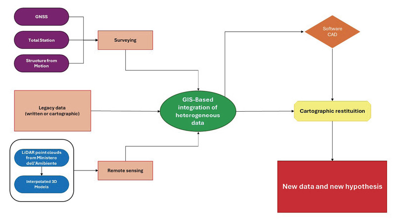
This study explores the GIS legacy data integration for a reassessment of the archaeological topography of Syracuse, with a focus on the Acquedotto del Paradiso. The research updates the understanding of Syracuse’s ancient waterscape by combining traditional archaeological methods with advanced digital technologies. Legacy data, historical maps, and recent fieldwork were systematically integrated into a GIS software, enhancing the spatial analysis and re-evaluation of the aqueduct’s route and construction phases. The study incorporated topographical bases, LiDAR point clouds, and autoptic analyses, revealing new insights into the aqueduct’s structural phases, including potential multi-phase construction and a double gallery system. The integration of these diverse datasets not only refined the known path of the aqueduct but also provided a detailed 2D and 3D visualization of it. This multidisciplinary approach emphasises the importance of combining traditional and modern techniques to improve the accuracy of archaeological topography, offering a more comprehensive understanding of ancient urban water supply systems in Syracuse.
Fifteen projects, running in a variety of hardware and software environments, are reviewed from throughout the United States and Mexico; work in other parts of the world by North Americans is also represented. Most applications occur at the regional level and represent either state sponsored archaeological management data bases or research databases. Most employ GIS to manage regional data queries and undertake visualization tasks; others focus more analytically on patterns of prehistoric settlement and land use at the regional level, with predictive models of archaeological location a management expression that relies heavily on research and analysis. Large interest is also shown in comprehensive within-site databases. Remotely sensed satellite data are being employed to construct base maps at the regional level while geophysical information is being incorporated in within-site databases. Although cost-surfaces and viewshed studies receive relatively little focus, there seems to be large interest in multitemporal studies that compare cultural differences and settlement patterns across the fourth dimension. The linkage of GIS with virtual reality and the increasing importance of the World Wide Web point to future directions the technology will take.
This paper is an attempt at an overview of recent GIS activities in Eastern Europe. The paper is composed of three parts. In the first section organisational characteristics and the historical background of Eastern European archaeology are briefly presented. The second section focuses on current GIS activities in most Central European countries. In the final section, general trends in archaeological GIS research and practice are summarised. In this section some suggestions for improvements through international co-operation are drawn. The paper is followed by the abbreviated results of the replies to the Caere Project questionnaire.
Digital maps linked to GIS platforms are extremely effective tools for the knowledge of the archaeological heritage and its management. Currently available GIS cloud is very useful for the remote sharing of archaeological data, because it is able to index and quickly retrieve heterogeneous information from large databases. A cartographic engine embedded in the system makes the cloud more powerful and allows users to share geospatial archaeological data quickly on the web. This is very important in collaborative research projects and for dissemination. The Laboratory of Ancient Topography, Archaeology and Remote Sensing of IBAM CNR is experimenting an open source suite to create a fully working GIS in the cloud system. This suite is composed of different databases (MySQL, postgreSQL, postGIS), a cartographic engine and a web client (QGIS server, QGIS Web Client), and a http server (Apache Web Server), all embedded in the owncloud cloud system. The system is currently being tested for the realization of the digital archaeological maps of the cities of Lecce and Taormina, now in progress in cooperation with the University of Salento and Messina and the Archaeological Superintendence of Apulia Region and Messina Province.
The present article is an attempt to emphasise some methodological concerns and evolutionary trends that characterise the use of GIS in Italian archaeological research. The cognitive base to attain this synthesis was offered by the analysis of answers to the questionnaire on “GIS and Archaeology”, that was distributed in the framework of the “Caere Project”, promoted within the more general “Progetto Finalizzato Beni Culturali” of the Italian CNR. The description of the results obtained follows a general definition of GIS and their capabilities. Computerised archaeological projects in which GIS are used nearly cover the entire national territory, from the Valle d’Aosta to Puglia and to the two principal islands. We have also recorded Italian projects that study archaeological areas outside the national limits. In general, there is a rather limited use of GIS in the management of archaeological excavations; in fact, the use of CAD software is more diffused. One of the emerging issues in GIS applications in archaeology is the distinction between projects carried out by institutions dealing with the administration and safeguarding of the national cultural patrimony and those carried out by the academic and research institutes. Cultural Resource Management in Italy is generally connected to the activities carried out by central and regional offices under the direction of the Ministry of Cultural Heritage and addressed to the problems of management, safeguarding, maintenance and exploitation of the national patrimony. As for GIS projects carried out in the framework of the research sector, one of the characteristics of Italian studies seems to be the presence of two areas of investigation: the first one pertains to regional studies while the second one is devoted to the study of ancient towns, either abandoned or obscured by modern evidence.
This paper discusses the way in which GIS applications have flourished in Australia and New Zealand through a combination of high levels of computer ownership, environmental awareness and the scale of the landscape relative to population. The paper covers administrative applications such as site registers; traditional landscape based research applications of GIS; and recent attempts to apply GIS to off-site archaeology and distributions of artefacts on a micro-topographic scale. The critical effects of data availability and the use of GPS are discussed, as well as research into extending GIS or desktop mapping to cope with chronological change. The paper concludes by looking at ways in which the use of GIS can be encouraged within the wider archaeological community, the importance of sharing digital map data and some ideas on future directions in the application of GIS within Australian and New Zealand archaeology.
The diffusion of the use of Geographical Information Systems in archaeology has considerably increased in recent years. This multiplicity of applications is due mainly to the growing interest of archaeologists in modern methodologies for the management of archaeological data, surveyed by topographic, photogrammetric and remote sensing techniques. GIS have become a fundamental tool for managing, sharing, analyzing and visualizing spatially referenced data and they are completely substituting the traditional techniques used by archaeologists, based upon filling out forms, graphics and other paper documents. Besides in the modern global society, dominated by mass media such as Internet, the issue of utilization has become more and more important, and most of the more recent GIS applications (Multimedia GIS, WebGIS) take this aspect into consideration.
The main use of GIS in archaeology is connected to regional research or management of excavation data sets. The use of GIS for urban archaeological research is far less extensive. The urban GIS about the medieval town of Pisa contains all archaeological data from occasional findings to modern stratigraphic excavations, geographical data, historical cartography data and urban data, each described by the geometrical shape (point, line, polygon) that best represents each feature. The distinguishing environmental context to which the town is connected is characterized by a complex hydrographic system; GIS analysis enabled us to study the relationships between the urban transformations and the surrounding environment. The article explains how geostatistical analysis allowed us to create a model of the ancient landscape and how the use of map algebra was useful in understanding the medieval environment. The difficulty in finding raw archaeological data, that is, all the excavation and fieldwork recording (planning of context, context recording sheet, photographs, findings quantification sheet), suggested the necessity to create an open digital archive and to provide possible standardization of digital formats, metadata records and archaeological data recording, so as to allow a comparison between the data.
This article illustrates the potential of multispectral satellite data for archaeological scope in the volcanic area of Mount Etna (Sicily, Italy). In particular, by adopting a post-dictive approach, GIS and FOSS technology was used to analyse different indices derived from World-View-2 multispectral data. The selected examples (two circular buildings and a wall-structure) illustrate successes and challenges of our method. The results indicate that NIR-1 and RED-EDGE are undoubtedly the most useful, while NDVI and SRI are the best performing indices.
The paper focuses on the preliminary assessment of the archaeological landscape around Tell Mardikh-Ebla (Syria). The ERC funded Ebla Chora Project allowed to conduct a systematic collection of findings from the site and its surrounding neighbors. The information from previous surveys was combined with the data from spatial datasets (topographical maps, aerial photos, satellite images, DEMs) in order to provide a first inventory of sites of the Eblaite chora. A preliminary interpretation of the development of settlement pattern and territory exploitation is now possible, especially for the Early Bronze Age (3rd millennium BC) when Ebla was the capital of a vast kingdom. Many potential sites were also detected, however their validation requires a field inspection which is currently suspended because of the civil war.
The authors illustrate the application of a GIS technology within the field of historical archaeology. They discuss a GIS pilot study of the Adriatic island of Hvar in Croatia, using the Geographical Resource Analysis Support System (GRASS), a Unix based software. Basic data was obtained through a survey of all the archaeological monuments on the island. In contrast to Greek literary sources, the GIS application gives a different perspective of the historical Greek colonisation of the island of Hvar (385/4 BC). In fact, after founding Pharos, there is no evidence of permanent Greek settlements extending beyond the plane, so the life of native communities would have continued unchanged.
The use of digital technologies has brought about a remarkable development in the field of archaelogical research. The combined use of tools such as GIS and DTM has guaranteed the possibility of simulating a few aspects of ancient landscapes, contributing to recognise the strategies on which the choice of the sites destined to become settlements in ancient times was based. In the Vaste-Poggiardo area (province of Lecce), systematic research made by the University of Salento has produced an incredibile amount of knowledge on archaelogical evidence dating back to between the Bronze Age and the Middle Ages; on the very basis of this data the experimentation of a spatial analysis in order to reconstruct the ancient landscape has been conducted. The management of the DTM, processed through QGis, has made it possible to use the outcome of spatial analysis to propose a clearer reconstruction of settlements in the Vaste area.
Due to the limited response to the CNR questionnaire on GIS usage in French archaeology, this paper cannot expect to give either the full extent of implementation, nor fully document its impact on this field of research. It has been possible however to extrapolate general trends, and to discuss the development of several projects and undertakings. The most important implementation of GIS is the Ministry of Culture’s nationwide SCALA program for French archaeological survey, and the most comprehensive is the CNRS’s ArchéoDATA Archaeological Information System (AIS). The majority of the smaller projects are in three sectors: regional governmental archaeological offices, the CNRS research laboratories and archaeological field units. As the majority of GIS projects are undertaken by small teams that are looking for flexibility and autonomy, the general trend in hardware/software configurations has been away from elaborate centralised systems and towards micro-computer based installations, with the combination usually being Map Info running on PCs and Macintoshs. Whilst the use of GIS is still not entirely common practice in French archaeology, it is important to note that considerable research is going into innovative ways of implementing GIS concepts in archaeology and that important results can be expected in the years to come.
Although archaeologists are using GIS technology at an accelerating rate, publication of their work has not kept pace. A state-of-the-art exploration the subject, GIS and Archaeological Site Location Modeling pulls together discussions of theory and methodology, scale, data, quantitative methods, and cultural resource management and uses location models and case studies to illustrate these concepts. This book, written by a distinguished group of international authors, reassesses the practice of
La carriera dell’ingegnere sammarinese Gino Zani (1882-1964) attraversa una fase cruciale del passaggio a una nuova forma di città. L’urgenza storica con cui si presenta la metropoli è, già di per sé, l’espressione stessa del moderno che scardina le tradizionali categorie interpretative. L’irruzione del moderno è però pervasiva, investe anche chi, come Zani, cercherà di opporre all’urto una resistenza conservativa.La città in Zani è inizialmente un risultato che emerge dagli sviluppi tecnologici come risposta pratica alle necessità, e si trasforma poi in un ambizioso obiettivo da raggiungere che, insieme allo spazio, deve coinvolgere la storia mitizzata della sua forma urbana. A una prima città moderna, la Reggio Calabria dei primi del Novecento, espressione di una borghesia urbana che tenta un riscatto dopo lo choc della distruzione del terremoto, succede così una seconda città, la San Marino degli anni Trenta, che, attraverso l’invenzione di una tradizione, si apriva ugualmente alla modernità travestita da borgo storico ricostruito. Il libro vede riuniti i lavori di autorevoli autori che hanno contribuito ad elevare la figura di Zani e una selezione dei suoi progetti.
As assyriologists have to handle tremendous amounts of important documents of ancient history written in cuneiform script, like the epic of Gilgamesh, we are developing an efficent system to support their daily tasks. Previous projects demonstrated the application of holography and early close-range 3D scanners for this task. Based on experiences from our previous projects in archaeology, we are focusing on processing the vast amounts of data of high resolution 3D models from todays close-range 3D scanners like the Breuckmann smartSCAN-3D-HE. The presented method exploits the high-resolution of the 3D models to extract the impressed characters as well as other features like fingerprints. Previous work typically used rendering techniques from computer graphics to visualize the characters, which then had to be processed manually. More recent approaches use methods from differential geometry for detection and extraction of coarse contour lines. These methods are computationally fast, and well-established for industrial application, but cannot cover the variations of human handwriting in form of the ? wedge shaped ? cuneiform script. To overcome the variations in size of the wedges, we choose a multiscale approach using integrating geometry. A transformation invariant function is achieved by calculating the volumes of multiple concentric spheres intersecting the volume below the 3D model's surface at each point. Due to this multiscale approach, this function is represented by the so-called feature vector. By classifying these feature vectors using auto-correlation, our system ? called GigaMesh ? can automatically extract characters, requiring only one parameter: the approximated line (wedge) width in mm. Results are shown for cuneiform tablets from the collections of the Assyriologie Heidelberg as well as from the Uruk-Warka Sammlung. Finally an outlook regarding character (en)coding and integration into related projects like the Cuneiform Digital Library Initiative (CDLI) is given.
An information system for the management of archaeological remains is presented here; it derives from the experience of the “Laboratorio di Informatica Archeologica - Dipartimento di Scienze Archeologiche - Pisa”. The guidelines followed during the project phase and the characteristics that make this system a reliable tool for work and research are examined. Finally, a possible evolution of the system is foreseen in order to improve access and diffusion of the data.