Nel Medioevo la costruzione o la ricostruzione di un luogo fortificato avveniva in tempi brevissimi. Solo una cosa contava: occupare rapidamente una posizione strategica. Le abilità tecniche dei costruttori erano dunque importantissime. Quali rocce sceglievano per ottenere il materiale edilizio? E quali tecniche utilizzavano per costruire le strutture di un castello? Il libro presenta i risultati di un’indagine condotta in Romagna su 34 siti, scelti in ambiti territoriali diversi tra loro. Un’opera che affronta con uno sguardo complessivo il tema dell’incastellamento a partire da una buona campionatura di siti; e li sottopone ad un’analisi approfondita che ne individua gli elementi costitutivi e li mette a confronto tra loro: materiali, paramenti, aperture, apparati decorativi ed altro ancora. Un testo ricco di grafici, tabelle, foto e rilievi stratigrafici inediti.
Il volume presenta il resoconto del restauro totale delle due statue del Museo Nazionale di Reggio Calabria portato avanti a cura dell’Istituto Centrale per il Restauro. Raccoglie i contributi di storici dell’arte, archeologi, chimici e fisici, sui vari aspetti del restauro e sui confronti con altre opere d’arte sottoposte a operazioni analoghe.I -
Lo scavo subacqueo condotto nel 1992 a Punta del Serrone (Brindisi) ha evidenziato un complesso di sculture in bronzo frammentarie di alto livello stilistico. Si tratta di settecento frammenti che si riferiscono a statue a grandezza naturale e colossali - databili fra la metà del IV sec. a.C. e il II sec. d.C. - raffiguranti divinità e personificazioni, intellettuali, personaggi di spicco sul piano politico-militare, membri di famiglie prestigiose o al potere. Al momento della dispersione in mare le sculture non costituivano più delle ‘opere d’arte’ ma si configuravano come un ‘carico di rottami’ destinato alla fusione: le statue sarebbero state imbarcate già in frammenti sulla nave destinata a trasportarle in Adriatico. Le sculture provenivano dalla Grecia: il dato si evince da più elementi, il più significativo dei quali è la presenza, nel complesso documentario, della statua di Polydeukion, il discepolo prediletto del celebre sofista ateniese Erode Attico. Nel contributo ci si sofferma in particolare sulla statua di una bambina di dimensioni reali di cui si conservano la testa e un braccio nudo adorno di un bracciale a forma di serpente. Il ritratto bronzeo della bambina da Punta del Serrone si confronta con una testa in marmo pentelico del Museo Nazionale di Atene: le due sculture raffigurano lo stesso personaggio e dipendono da un unico prototipo. Ai fini della datazione significativa è l’acconciatura che caratterizza sia le statue delle figlie di Marco Aurelio sia la ritrattistica privata di età antonina. La bambina raffigurata nei ritratti di Brindisi e di Atene non appartiene alla casa imperiale ma alla famiglia di un esponente della classe dirigente. In questa figura di spicco non è difficile riconoscere Erode Attico e la bambina potrebbe essere una delle figlie del sofista.
On July 19, 1992, in the waters of Punta del Serrone (Brindisi, Italy), over 200 fragments of bronze statues of exceptional manufacture were found. This paper traces the history of the exceptional discovery and fate of the finds. The first part deals with the recovery, conservation and exhibition and the main phases of the analytical study that led to their identification and the reconstruction of the events that caused their abandonment on the seabed. The second part is dedicated to the digital acquisition and processing of the statues through laser scanning and to the virtual restoration and creative modeling of some of them, carried out on the occasion of ‘Nel mare dell’intimità/In the sea of intimacy’, an exhibition set up at the Brindisi airport between July 2019 and January 2021. The third and last part discusses the making of the computer animation video ‘Rottami preziosi. Una ballata del mare profondo/Precious scrap. A ballad from the deep sea’, created for the exhibition, and dedicated to telling the story of the bronzes, retracing the different phases of the creative process and the solutions developed to combine all the available data in a functional narrative.
The recent excavation campaigns launched by the Universities of Campania ‘Luigi Vanvitelli’, of Tuscia and of Bonn at Monte Abatone (Cerveteri) have also brought to light the first infant’s tomb of the necropolis. This small shaft tomb (n° 643) can be dated to just after the mid-7th century B.C.E., and was probably that of a little girl. The tomb is dug into the mound of tomb 73, belonging to the second quarter of the 7th century B.C.E. Its position, chronology and grave goods suggest that the two tombs belong to members of the same family group, and that the location of this shaft burial outside is due to the young age of the deceased. There are no specific studies on child funeral rituality at Cerveteri. Any investigation is rendered much more complex by the almost total absence of anthropological evidence and the difficulty of identifying any infant burial inside the chamber tombs. The sole relatively trustworthy documentation concerns shaft tombs of small dimensions scattered among the mounds and chamber tombs, like this one at Monte Abatone. An analysis of the documentation in the Vecchio Recinto sector of Banditaccia published in the 1955 edition of Monumenti Antichi has provided over one hundred shaft tombs with a length of less than 120 cm, which probably refer to children from perinatal to 4-5 years of age at the most, dating from 7th to 3th century B.C.E. The number of tombs is wholly insufficient to represent the infant mortality of the community in the period considered, but it does evidence the especial care paid to at least some of the community’s children, even very young. This article takes into account these tombs from the point of view of their shape and grave goods. About twenty-five percent are sarcophagus-type, a typology that appears to have been used only for children. Most of the children’s tombs have modest grave goods. Only in very few cases are there objects evidently connected to the role and social rank that the child would have played in adulthood. As has already occurred for other cultural areas, for Cerveteri too an analysis of the archaeological data leads to a re-examination of the idea that very young children were excluded from the right of burial in the necropolis. Moreover the comparison with archaeological and anthropological data from the necropoleis of the Monti della Tolfa district suggests that some children could also be buried in the chamber tombs. At the same time, attention shifts to factors (clearly other than age alone) that limited their access to formal burial: a problem which, as we know, also concerns adults.
La republication par J. Boube de l'inscription I.A. M., 2, 307, oblige à une nouvelle interprétation de ce document. Le jeune Q. Antonius, C(aii) f(ilius), Tranquillus Saturninus ne peut plus être considéré comme un decurión, ni donc comme un citoyen de Volubilis. Il est decurion et citoyen de Sala. Mais, du même coup, son appartenance à la tribu Claudia tend à démontrer que les citoyens de Sala étaient inscrits dans la même tribu. Comme c'est l'empereur Claude qui conféra la tribu Claudia, en Mauretanie Tingitane comme dans d'autres provinces, aux cités qu'il transforma en municipes ou en colonies, on peut en déduire que le municipe de Sala, tout comme celui de Volubilis, doit sa création à Claude, et non point à Trajan, comme on l'a parfois supposé.
Data coming from necropolis excavations constitute the base of an information programme, which permits the integration between a descriptive database and a computer graphics programme. Each grave has been drawn using a system of photographic correction and recorded in a CAD programme. Therefore, these drawings are automatically positioned on a general map in their original location. The description of the graves is recorded in a relational database and every grave drawing is connected to the relative file. In this way, by performing queries to the database, it is possible to immediately visualize the corresponding graves and to realize, for example, typological and chronological maps. This paper gives examples from the medieval necropolis of Sous-le-Scex at Sion, in Switzerland.
ABSTRACT Study of the climate in the Mediterranean basin during different historical periods has taken on a particular importance, particularly regarding its role (together with other factors) in the evolution of human settlement patterns. Although the Roman age is traditionally considered a period with a favourable climate, recent studies have revealed considerable complexity in terms of regional climate variations. In this paper, we compare the hydrological change from speleothem proxy records with flood reconstructions from archaeological sites for Northern Tuscany (central Italy). We identify a period of oscillating climatic conditions culminating in a multidecadal dry event during the 1st century bc , followed by a century of increased precipitation at the beginning of the Roman Empire and subsequently a return to drier conditions in the 2nd century ad. The period of rainfall increase documented by the speleothems agrees with both the archaeological flood record as well as historical flood data available for the Tiber River, ca. 300 km to the south. These data also suggest a return to wetter conditions following the 3nd and 4rd centuries ad.
Research on the fundamental processes of flow, solute transport and immobilization, and forced degradation of contaminants in groundwater needs to be further advanced to enhance and guarantee groundwater availability. In line with this, current research has seen a transition to more engineering-related topics. These proceedings feature both current and future research on both traditional and tracer techniques. Engineering-related tools apply to advanced methods of groundwater protection and management, and reveal more about the elastic or rigid responses of subsurface systems to contaminant inputs. The proceedings cover groundwater exploitation, pollution, management and protection, geophysical and experimental works, modelling of flow and transport and the appropriate use of environmental and artificial tracers. The scale of research ranges from the laboratory to integrated field studies.
This paper presents an algorithm for large-scale automatic detection of burial mounds, one of the most common types of archaeological sites globally, using LiDAR and multispectral satellite data. Although previous attempts were able to detect a good proportion of the known mounds in a given area, they still presented high numbers of false positives and low precision values. Our proposed approach combines random forest for soil classification using multitemporal multispectral Sentinel-2 data and a deep learning model using YOLOv3 on LiDAR data previously pre-processed using a multi–scale relief model. The resulting algorithm significantly improves previous attempts with a detection rate of 89.5%, an average precision of 66.75%, a recall value of 0.64 and a precision of 0.97, which allowed, with a small set of training data, the detection of 10,527 burial mounds over an area of near 30,000 km2, the largest in which such an approach has ever been applied. The open code and platforms employed to develop the algorithm allow this method to be applied anywhere LiDAR data or high-resolution digital terrain models are available.
Thom considers that many of the dimensions of megalithic sites can be expressed in terms of a quantum of 6.44 ft (1.66 m). The problem of detecting a quantum when its size is not known in advance has been studied in pioneer papers by Broadbent (1955, 1956). With the greatly increased volume of evidence now available, a renewed attack on this problem seems called for, and a new approach, based on a Fourier analysis, will be outlined here. With samples of sufficient size, testing for the presence of a quantum is equivalent to testing a section of a realization of a Gaussian stochastic process, stationary under time shifts, for an unduly large supremum. If the test is not to be prejudiced by prior decisions about the fittings of ‘eggs’, ‘fans’, etc., then only data from circle-diameters can be used. This reduces the sample size, and so the asymptotic theory has to be supplemented by ‘ Monte Carlo ’ runs with simulated data (with and without a built-in quantum effect). It already seems clear that agreement on the data-set to be used in the analysis is the vital prerequisite for a decisive test of the quantum hypothesis.
Archaeological and volcanological studies have revealed that eruptions of Neapolitan volcanoes have conditioned human settlement patterns since prehistoric times. The occurrence of high intensity explosive eruptions, interspersed with long periods of quiescence, has characterized the last 10 ka of activity of these volcanoes. Geoarchaeological studies, carried out in advance of investigations for the construction of the Rome-Naples and the new Naples-Bari railway lines, have made possible a detailed reconstruction of human presence in the central part of the Campania Plain up to the coastal strip, between the late Neolithic and the late Bronze Age. The examined chronological interval includes sequences of pyroclastic deposits erupted by both Campi Flegrei and Somma-Vesuvius, and paleosols with evidence of anthropic frequentation. Altogether, the geoarchaeological data have provided a detailed picture of human settlement and activities through time with a particular focus on a long period of quiescence of the two volcanoes and also during their intense activity.
The aim of this research is to define a new methodology in order to reconstruct the historical human mobility network in mountain areas in a perspective of ‘longue durée’. Through the match of different types of data, in particular historical and archaeological sources, the analysis of environmental features and the application of a series of algorithms on a GIS platform, we produced a series of maps of possible mobility networks. The comparison between them and with the historical cartography emphasizes both continuities and breaks over time and outlines the reliability of the elaborations obtained. Our focus is a small region in the North-Eastern Italy, called Feltrino (BL), on a time frame from the Bronze Age to the modern times
This is a early draft edited volume of contributions to the ‘How To Do Archaeological Science Using R’ forum of the 2017 Society of American Archaeology annual meeting.
The integration of field survey data from Eastern Sicily (the Plain of Catania) with legacy data available for the region will expand our knowledge on Mediterranean ancient rural landscapes. With an extent of 430 km2, the area is a perfect case study due to its geographical characteristics and the number of archaeological projects (both excavations and surveys) carried out within it in recent decades. Indeed, combining archaeological data from earlier research projects with new survey data allows us to conduct a settlement pattern analysis of the project’s study area. Heterogenous datasets have been integrated through their implementation into a geo-database, featuring the management and integration of topographical units and archaeological entities through semantic relations. Through geospatial data analysis based on the complete gazetteer of archaeological sites (whether sherd scatters, ruins, caves dwellings, tombs or tracks), a new image of rural landscapes for this area of Eastern Sicily from the Greek Archaic to the Late Roman Age can be visualized, beyond the traditional Sicilia frumentaria narrative.
This article considers the issue of opacity as a problem for socially consequential mechanisms of classification and ranking, such as spam filters, credit card ...
This paper reviews the ways in which assemblages of pottery have been quantified throughout the twentieth century, and the use to which such data have been put. The values of various ways of quantifying pottery are compared, and a theoretical basis for the comparison of assemblages is described. Finally, the practical steps that need to be taken to make best use of the theory are set out.
Big Data and Archaeology presents the papers from two sessions of the 18th UISPP World Congress (Paris, June 2018): Session III-1 (CA): 'Big data, databases and archaeology', and Session III-1 (T): 'New advances in theoretical archaeology'. The advent of Big Data is a recent and debated issue in Digital Archaeology. Historiographic context and current developments are illustrated in this volume, as well as comprehensive examples of a multidisciplinary and integrative approach to the recording, management and exploitation of excavation data and documents produced over a long period of archaeological research. In addition, specific attention is paid to neoprocessual archaeology, as a new platform aimed at renewing the theoretical framework of archaeology after thirty years of post-modernism, and to the refinement of the concept of archaeological cultures, combining processual, contextual and empirical approaches.
Archaeological data are shadowy in a number of senses. They are notoriously incomplete and fragmentary, and the sedimented layers of interpretive scaffolding on which archaeologists rely to constitute these data as evidence carry the risk that they will recognize only those data that conform to expectation. These epistemic anxieties further suggest that, once recovered, there is little prospect for putting "legacy" data to work in new ways. And yet the "data imprints" of past lives are a rich evidential resource; archaeologists successfully mine old data sets for new insights that redirect inquiry, often calling into question assumptions embedded in the scaffolding that made their recovery possible in the first place. I characterize three strategies by which archaeologists address the challenges posed by legacy data: secondary retrieval and recontextualization of primary data, and the use old data in experimental simulations of the cultural past under study. By these means, archaeologists establish evidential claims of varying degrees of credibility, not by securing empirical bedrock but through a process of continuously building and rebuilding provisional empirical foundations.
This paper explores long-term trends in human population and vegetation change in the Levant from the early to the late Holocene in order to assess when and how human impact has shaped the region’s landscapes over the millennia. To do so, we employed multiple proxies and compared archaeological, pollen and palaeoclimate data within a multi-scalar approach in order to assess how Holocene landscape dynamics change at different geographical scales. We based our analysis on 14 fossil pollen sequences and applied a hierarchical agglomerative clustering and community classification in order to define groups of vegetation types (e.g. grassland, wetland, woodland, etc.). Human impact on the landscape has been assessed by the analysis of pollen indicator groups. Archaeological settlement data and Summed Probability Distribution (SPD) of radiocarbon dates have been used to reconstruct long-term demographic trends. In this study, for the first time, the evolution of the human population is estimated statistically and compared with environmental proxies for assessing the interplay of biotic and abiotic factors in shaping the Holocene landscapes in the Levant.
The archaeological survey of architectures, if supported by structural and diagnostic analyses, can offer the possibility of documenting and interpreting transformations undergone by buildings related to specific dynamics in response to destructive natural events occurring over time. This data, if correctly interpreted, can have significant repercussions in areas where the knowledge of historical seismicity is conditioned by the lack of historical sources. A case study is offered by the Casentino, a territory located in eastern Tuscany in the province of Arezzo. The area has been affected by a number of historical earthquakes and features numerous architectural evidence related to the medieval period, many of which are still in exceptionally well-preserved condition. The archaeological analyses carried out on the architecture in this area along with construction material characterization, three-dimensional surveys, and the diagnostic analyses have permitted the documentation of instabilities and restoration activities related to possible traumatic events, offering newfound insights both from the historical-constructive point of view and in relation to the chronologies and dynamics linked to historical seismicity.
Founded, according to legend, by Romulus and Remus in 753 BC, Rome was first the centre of the Roman Republic, then of the Roman Empire, and it became the capital of the Christian world in the 4th century. The World ...
Building Information Modelling, new paradigm of digital design and management, shows great potential for the refurbishment process, as it represents a possible way out of criticalities that occur in documentation and preservation of existing assets, if connected to cognitive automation. The combination of BIM with automation systems improves the quality control during diagnosis, design and work execution, and the labour savings, which is particularly relevant for rapid intervention in case of hazardous conditions. Therefore, the paper is going to address a methodological discussion concerning complete “as-built” parametric models of historical buildings, supporting the design of refurbishment and conservation interventions. Although some reviews of the state of the art exist on the topic of Historic Building Information Modelling, the present research introduces a different perspective on HBIM modelling, with diagnosis and performance assessment as key-aspects, in terms of automating performance assessment. Specifically, from the data collection of contributions regarding HBIM/BIM, diagnostics and monitoring on existing buildings and infrastructures, a critical review by selected criteria is developed. Nevertheless, general methods and tools for information management and exchange tasks in BIM are briefly described as well, since they are considered useful for future developments of HBIM approach. The core of the critical analysis is focused on the scientific and technical relations among HBIM models, diagnosis and performance assessment features. In addition, the review identifies specific activities and relative tools and methods for knowledge acquisition and semantic enrichment. Finally, gaps in knowledge of the current literature are outlined and discussed, with specific focus on performance assessment in HBIM. In this regard, a new methodology toward Diagnosis-Aided Historic Building Information Modelling and Management (DA-HBIMM) is proposed as a framework to be developed in order to address smart knowledge acquisition, collection and notification of assessed performances and eventual risks, by cognitive automation and artificial intelligence, in the near future.
The purpose of this research is to outline in detail the procedure of remote data capture using laser scanning and the subsequent processing required in order to identify a new methodology for creating full engineering drawings (orthographic and 3D models) from laser scan and image survey data for historic structures. Design/methodology/approach – Historic building information modelling (HBIM) is proposed as a new system of modelling historic structures; the HBIM process begins with remote collection of survey data using a terrestrial laser scanner combined with digital cameras. A range of software programs is then used to combine the image and scan data. Findings – Meshing of the point cloud followed by texturing from the image data creates a framework for the creation of a 3D model. Mapping of BIM objects onto the 3D surface model is the final stage in the reverse engineering process, creating full 2D and 3D models including detail behind the object's surface concerning its methods of construction and material makeup, this new process is described as HBIM. Originality/value – The future research within this area will concentrate on three main stands. The initial strand is to attempt improve the application of geometric descriptive language to build complex parametric objects. The second stand is the development of a library of parametric based on historic data (from Vitruvius to 18th century architectural pattern books). Finally, while it is possible to plot parametric objects onto the laser scan data, there is need to identify intermediate software platforms to accelerate this stage within the HBIM framework.
Historic Building Information Modelling (HBIM) is a novel prototype library of parametric objects, based on historic architectural data and a system of cross platform programmes for mapping parametric objects onto point cloud and image survey data. The HBIM process begins with remote collection of survey data using a terrestrial laser scanner combined with digital photo modelling. The next stage involves the design and construction of a parametric library of objects, which are based on the manuscripts ranging from Vitruvius to 18th century architectural pattern books. In building parametric objects, the problem of file format and exchange of data has been overcome within the BIM ArchiCAD software platform by using geometric descriptive language (GDL). The plotting of parametric objects onto the laser scan surveys as building components to create or form the entire building is the final stage in the reverse engineering process. The final HBIM product is the creation of full 3D models including detail behind the object’s surface concerning its methods of construction and material make-up. The resultant HBIM can automatically create cut sections, details and schedules in addition to the orthographic projections and 3D models (wire frame or textured) for both the analysis and conservation of historic objects, structures and environments.
Le projet Archives de l’Archéologie Européenne (AREA) s’est attaché depuis sa fondation en 1999, à retracer les étapes de la constitution de l’archéologie en Europe et à inventorier les fonds d’archives qui s’y rapportent. L’exposition Histoires d’archéologie. De l’objet à l’étude, en parallèle au bilan du dernier des projets AREA (2006-2008), s’est attachée à montrer quelques exemples des chemins qui ont mené les antiquaires à jeter les bases de l’archéologie au sens moderne du terme. L’exposition se déroula du 15 janvier au 12 avril 2009. Les commissaires étaient Irène Aghion, Mathilde Avisseau-Broustet et Dominique Morelon.
The (re)occupation of hillforts was a distinctive feature of post-Roman Europe in the fifth to seventh centuries ad. In western and northern Britain, hillforts are interpreted as power centres associated with militarized elites, but research has paid less attention to their landscape context, hence we know little about the factors that influenced their siting and how this facilitated elite power. Geographic Information Systems (GIS) provide opportunities for landscape research, but are constrained by limitations of source data and the difficulty of defining appropriate parameters for analysis. This article presents a new methodology that combines data processing and analytical functions in GIS with techniques and principles drawn from ‘traditional’ landscape archaeology. A case study, focused on Dinas Powys, suggests that the strategic siting of this hillfort facilitated control over the landscape and has wider implications for our understanding of patterns of power in post-Roman Britain., L'occupation (ou réoccupation) de sites de hauteur fortifiés est un trait caractéristique de l'Europe post-romaine, entre le Ve et le VIIe siècle apr. J.-C. Dans l'ouest et le nord de la Grande-Bretagne, on interprète les sites de hauteur fortifiés comme représentant des centres de pouvoir associés à des élites militarisées, mais le paysage dans lequel ils s'inscrivent est moins bien connu. Nous sommes donc mal informés sur les facteurs qui ont influencé leur implantation et comment leur position topographique a facilité l'exercice du pouvoir des élites. Les systèmes d'information géographique (SIG) nous permettent d’étudier le paysage mais sont limités par les données de base et par les difficultés de définir des paramètres d'analyse adéquats. Les auteurs de cet article présentent une nouvelle approche méthodologique qui combine le traitement des données et les fonctions analytiques des SIG avec les techniques et principes de l'analyse « traditionnelle » du paysage en archéologie. Un cas d’étude, Dinas Powys au Pays de Galles, démontre que la position de ce site de hauteur fortifié lui permettait de contrôler le paysage environnant et ceci a des répercutions plus profondes sur notre aptitude à déchiffrer l'organisation du pouvoir en Grande-Bretagne à l’époque post-romaine. Translation by Madeleine Hummler, Die (Wieder-) Besiedlung von befestigten Höhensiedlungen war ein Kennzeichen der nachrömischen Zeit in Europa, im 5. bis 7. Jahrhundert n. Chr. Im britischen Westen und Norden werden die befestigten Höhensiedlungen als Machtzentren einer militarisierten Elite gedeutet, aber der landschaftliche Rahmen dieser Höhensiedlungen ist weniger gut erforscht. Deswegen sind die Umstände, welche die Standortwahl beeinflusst haben und die Machtausübung der Elite gefördert haben, nur wenig bekannt. Die Methoden der GIS-Analyse ermöglichen es, die Landschaft zu untersuchen, aber die Analyse ist durch die Beschränkungen der Datenquellen und Schwierigkeiten in der Bestimmung von geeigneten Parametern behindert. In diesem Artikel wird eine neue methodologische Vorgehensweise vorgestellt: Diese kombiniert die Datenverarbeitungsleistungen und analytischen Funktionen des GIS mit den Methoden und Grundsätzen der „traditionellen“ Landschaftsarchäologie. Eine Fallstudie, Dinas Powys in Wales, zeigt, dass die strategische Lage der befestigten Höhensiedlung die Überwachung der umgebenden Landschaft erleichterte. Dies hat weitreichende Folgen für unser Verständnis der Ausübung der Macht in nachrömischer Zeit in Großbritannien. Translation by Madeleine Hummler
These two volumes present the results of the painstaking pedestrian site-by-site survey of the Southern Samaria region, the heartland of Biblical Israel. More than 500 sites have been identified and are indexed for easy reference. The excellent aerial photographs accompanying the description of the sites are of immense historical interest. These are unique documents of a vanished countryside now built over to accommodate an increased population. The detailed archaeological report covers finds from all periods, including Byzantine and Medieaval, and incorporates a comprehensive review of historical sources.
High-speed 3D shape measurement (or imaging) has seen tremendous growths over the past decades, especially the past few years due to the improved speed of computing devices and reduced costs of hardware components. 3D shape measurement technologies have started penetrating more into our daily lives than ever before with the recent release of iPhone X that has an built-in 3D sensor for Face ID, along with prior commercial success of inexpensive commercial sensors (e.g., Microsoft Kinect). This paper overviews the primary state-of-the-art 3D shape measurement techniques based on structured light methods, especially those that could achieve high measurement speed and accuracy. The fundamental principles behind those technologies will be elucidated, experimental results will be presented to demonstrate capabilities and/or limitations for those popular techniques, and finally present our perspectives on those remaining challenges to be conquered to make advanced 3D shape measurement techniques ubiquitous.
The site of Norba is located in the Latium Region, about 90 km S of Rome, Italy. The city is one of the best example of urban town planning, with a regular layout dating back to antiquity. Over the years, many studies and archaeological excavations have brought to light important remains of several buildings, which are still very well preserved. To enhance the knowledge of the unexcavated portions of the archaeological site and to locate the position of the unknown and hypothesized buried structures, extensive geophysical surveys employing the Ground Penetrating Radar (GPR) and Gradiometric methods were planned and conducted between 2017 and 2018. For the measurements, a GPR system SIR3000 (GSSI), equipped with a 400 MHz bistatic antenna with constant offset, was used to survey 27 different sectors close to few excavated areas. Taking into account the environmental conditions of the site and the nature of the buried structures, some areas were surveyed with a spacing interval between parallel profiles of 0.25 m while other areas were investigated with a spatial interval between closed parallel profiles of 0.50 m. Furthermore, fluxgate differential magnetic (Gradiometric) surveys were carried out using the geoscan FM256 in two areas, overlapping the GPR areas. In order to have a better understanding of the subsurface, methods of qualitative and quantitative integration of the results have been employed: maps overlays and RGB color composites (graphical integration), binary data analysis and cluster analysis (discrete data integration), and data sum, data product and principal component analysis (continuous data integration). The results obtained from the geophysical surveys were interpreted together with the archaeologists to define the meaning of the structures identified and to enhance the knowledge of the ancient town’s layout and mapping.
Il decimo volume della serie “Hierapolis di Frigia” costituisce la pubblicazione analitica di uno dei contesti architettonici più importanti della città frigia, il cosiddetto Tempio A del Santuario di Apollo, edificio connesso alle pratiche per la
The paper deals with some of the results of the research activities of the IBAM-CNR in the project «Il Mediterraneo antico e medievale come luogo di incontro tra Oriente e Occidente, Nord e Sud», conducted as part of the activities of the Italian Archaeological Mission in Hierapolis of Phrygia (Turkey). During the archaeological surveys in 2004-2007 satellite images with high geometric, radiometric and spectral resolutions, that constituted important tools for the research in the city and in its territory, were used because vertical aerial photos and recent detailed maps were not available. During the surveys some computer applications were also developed, such as a system which is able to facilitate and accelerate the task of positioning and managing the archaeological finds, using a palm-top computer or a Tablet PC integrated with a GPS antenna and a software for archaeological navigation and management of survey records called Ulixes, which is still in the prototype phase. The purpose of the system is to enable the users to navigate employing maps which they have chosen, or, as in the case of Hierapolis, using high resolution satellite images. In the event of an archaeological discovery, it is possible to memorise its position and metadata consisting of a record in which the geographical coordinates and a detailed description of the type of discovery are inserted. Exemplificative of the applied methodologies is the study of the aqueducts which brought water to Hierapolis. During the surveys in the territory around the ancient city three main routes were identified, documented and positioned. For the study, the reconstruction and the visualization of these routes, DEMs were also used, on which high resolution satellite images and imported waypoints from the GPS receivers used in the field work were draped.
This article discusses an approach to spatial analysis which is more closely tailored to archaeological objectives and archaeological data than are more "traditional" quantitative techniques such as nearest neighbor analysis. Heuristic methods, methods which make use of the problem context and which are guided in part by intuitively derived "rules," are discussed in general and with reference to the problem of spatial analysis in archaeology. A preliminary implementation of such a method is described and applied to artificial settlement data and artifact distributions from the Magdalenian camp of Pincevent. Finally, the prospects for further development of heuristic methods are elaborated.
Over the past two decades, there has been a proliferation of software to create great 3D models of archaeological sites and objects, and there has been plenty of thought and discussion on data models for finds. The results of those efforts have been made public through institutional websites and specific portals, but now, a further step is necessary: the cultural heritage data and (meta)data need to be taken into the semantic web. The Heritage Online Visualisation Engine (further: Heron VE) provides tools for documenting, visualising and disseminating the semantic relations between sites, objects, documentation and narratives. Heron VE is scalable: it can be used to tell the story of a particular archaeological complex, but it can also illustrate relations between sites and objects which are widely separated in both time and space. With Heron VE, dissemination of (meta)data can take many different forms: Heron VE contains modules for presenting and reporting on data, but it can also be used to provide data only, for example in several XML-formats or in N-triples. The designer of Heron VE has 25 years of experience with cultural heritage data in the field of archaeology, museums and libraries and has been working on the structured dissemination of cultural heritage data, first in the semantic web and now within the framework of linked data. This paper will illustrate the journey towards Heron VE, including considerations regarding the adoption, adaptation or rejection of existing data models and ontologies. It will also contain examples. These will mainly be based on data regarding sites of former castles and stately homes in the Netherlands, but it will become very clear that the Heron VE can be applied to many different cultural heritage datasets, including those regarding ancient urban areas.
This is the first volume specifically dedicated to the consolidation and clarification of Heritage Studies as a distinct field with its own means of investigation. It presents the range of methods that can be used and illustrates their application through case studies from different parts of the world, including the UK and USA. The challenge that the collection makes explicit is that Heritage Studies must develop a stronger recognition of the scope and nature of its data and a concise yet explorative understanding of its analytical methods. The methods considered fall within three broad categories: textual/discourse analysis, methods for investigating people’s attitudes and behaviour; and methods for exploring the material qualities of heritage. The methods discussed and illustrated range from techniques such as text analysis, interviews, participant observation, to semiotic analysis of heritage sites and the use of GIS. Each paper discusses the ways in which methods used in social analysis generally are explored and adapted to the specific demands that arise when applied to the investigation of heritage in its many forms. Heritage Studies is a seminal volume that will help to define the field. The global perspective and the shared focus upon the development of reflexive methodologies ensure that the volume explores these central issues in a manner that is simultaneously case-specific and of general relevance.
“Heritage science is the study of interpretation and management of the material evidence of the humankind. It enables both society and individuals to exercise their right to cultural heritage and contributes to our understanding of who we are and our sense of place. Heritage science demonstrates its relevance to, as well as its deep roots in chemistry, and in other physical and engineering sciences …” Read more in the Guest Editorial by Matija Strlič.
This paper describes a system for documenting scientific data produced in Heritage Sciences. The system is built around a general meta-model, flexible enough to provide descriptions, in a formal language, of the datasets produced by scientific research. Resulting metadata can be re-encoded and published in multiple formats. The underlying metadata schema is inspired by CIDOC CRM principles for data modelling and maintains a full compatibility with CIDOC CRM ontology to capture provenance and foster interoperability with Cultural Heritage information. The use of a wide set of thesauri and controlled vocabularies guarantees internal coherence at data and metadata level. Applicability tests are underway at different institutions and a set of user interfaces has been designed to simplify and speed up the process of data gathering and metadata definition.
The importance of landscape and heritage recording and documentation with optical remote sensing sensors is well recognized at international level. The continuous development of new sensors, data capture methodologies and multi-resolution 3D representations, contributes significantly to the digital 3D documentation, mapping, conservation and representation of landscapes and heritages and to the growth of research in this field. This article reviews the actual optical 3D measurement sensors and 3D modeling techniques, with their limitations and potentialities, requirements and specifications. Examples of 3D surveying and modeling of heritage sites and objects are also shown throughout the paper.
Building Information Modelling (BIM) is being debated, tested and implemented wherever you look across the built environment sector. This book is about Heritage Building Information Modelling (HBIM), which necessarily differs from the commonplace applications of BIM to new construction. Where BIM is being used, the focus is still very much on design and construction. However, its use as an operational and management tool for existing buildings, particularly heritage buildings, is lagging behind.
Healthy Living in Late Renaissance Italy explores in detail the efforts made by men and women in late Renaissance Italy to stay healthy and prolong their lives. Drawing on a wide variety of sources - ranging from cheap healthy living guides in the vernacular to personal letters, conduct literature, household inventories, and surviving images and objects - this volume demonstrates that a sophisticated culture of prevention was being developed in sixteenth-century Italian cities. This culture sought to regulate the factors thought to influence health, and centred particularly on the home and domestic routines such as sleep patterns, food and drink consumption, forms of exercise, hygiene, control of emotions, and monitoring the air quality to which the body was exposed. Concerns about healthy living also had a substantial impact on the design of homes and the dissemination of a range of household objects. This study thus reveals the forgotten role of medical concerns in shaping everyday life and domestic material culture. However, medicine was not the sole factor responsible for these changes. The surge of interest in preventive medicine received new impetus from the development of the print industry. Moreover, it was fuelled by classical notions of wellbeing, re-proposed by humanist culture and by the new interest in geography and climates. Broader social and religious trends also played a key role; most significantly, the nexus between attention to one's health and spiritual and moral worth promoted both by new ideas of what constituted nobility and by the Counter-Reformation. Six key areas were thought to influence the balance of 'humours' within the body and Healthy Living in Late Renaissance Italy is organised into six main chapters which reflect these concerns: Air, Exercise, Sleep, Food and Drink, Managing the Emotions, and Bodily Hygiene. The volume is richly illustrated, and offers an accessible but fascinating glimpse into both the domestic lives and health preoccupations of the early modern Italians.
Data collection, documentation and analysis of the traces of ancient ruins and archaeological sites represent an inestimable value to be handed down to future generations. Thanks to the development of new technologies in the field of computer graphics, Building Information Modelling (BIM), Virtual Reality (VR) and three-dimensional (3D) digital survey, this research proposes new levels of interactivity between users and virtual environments capable of communicating the tangible and intangible values of remains of ancient ruins. In this particular field of development, 3D drawing and digital modelling are based on the application of new Scan-to-HBIM-to-VR specifications capable of transforming simple points (point clouds) into mathematical models and digital information. Thanks to the direct application of novel grades of generation (GOG) and accuracy (GOA) it has been possible to go beyond the creation of complex models for heritage BIM (HBIM) and explore the creation of informative 3D representation composed by sub-elements (granular HBIM objects) characterized by a further level of knowledge. The value of measurement, 3D drawing and digital modelling have been investigated from the scientific point of view and oriented to the generation of a holistic model able to relate both with architects, engineers, and surveyors but also with archaeologists, restorers and virtual tourists.Highlights:The concept of ‘granular HBIM objects’ is introduced to show the unexpressed potential of the scan-to-BIM process for different types of data analyses and uses.Sustainable development of VR projects for archaeological sites is proposed, allowing users to discover the hidden historical values with new levels of interactivity and information.HBIM and VR projects have been improved through the integration of laser scanning, digital photogrammetry (terrestrial and UAV) and advanced modelling techniques.
This study describes the technical-systemic and conceptual-informative interoperability tests for the integration of a Historic Building Information Modeling (HBIM) model in a 3D Geographic Information System (GIS) environment aimed to provide complete and useful documentation for multiscale analyses on cultural heritage particularly exposed to risks. The case study of the San Lorenzo Church in Norcia (Italy) has been chosen given the urgent need to update the existing documentation for its protection and conservation issues, due to the extensive damage suffered after the series of earthquakes that occurred in central Italy starting from summer 2016. Different tests to evaluate two levels of conceptual interoperability (technical and semantic) when importing the HBIM model into a GIS environment were performed, whether with commercial software or with open source ones (ArcGIS Pro and QGIS, respectively). A data integration platform (Feature Manipulation Engine, FME) has been used for converting the IFC (Industry Foundation Classes) data format into the GML (Geography Markup Language) format, in order to obtain a unique and unified model and vocabulary for the 3D GIS project, structured with different levels of detail, according to CityGML standard. Finally, as HBIM-GIS integration is considered, the loss of geometric and informative data has been taken into account and evaluated.
The paper illustrates the possibility to shift from a 3D content model to a Historic Building Information Modelling (HBIM) in order to support conservation and management of built heritage. This three-dimensional solution is based on parametric models, suitable for industrial elements and modern architecture, that can be usefully applied to heritage documentation and management of the data on conservation practices. In this sense, the research investigates the definition of an HBIM targeted library, starting from surface surveying and representation towards the logic of object definition. In order to promote wider use and uptake of these 3D object modelling instruments, some case studies are illustrated by the paper. Vault and wooden beam floor analysis show how HBIM for architectural heritage could be implemented in order to assemble different kind of data on historical buildings, such as e.g. dimensional, geometrical, thematic, historical and architectural information.
The development of advanced survey techniques in the last years is offering a wide set of tools for implementing the building analysis. In the preservation field, the use of 3D interactive models is a prerogative of few and rare excellent cases and the information contained in high-resolution virtual representation are only partially developed. In the past centuries, the representation was centred on the theoretical roles of the descriptive geometry devoted to the representation of the architectural elements complexity in the space to manage the construction site process. It has been progressively lost the past skill to managing 3D objects in the space. Being HBIM based on 3D solids representation, the theme of the 3D model comes back to the foreground. The complexity of the architectural heritage and its components is evidencing a gap of best practices, protocols and specification in the HBIM-modeling. Do-It-Yourself modeling process has been characterised by the first phase of HBIM generation in the last years. Modeling phase within HBIM is left to the single responsibility, with lack of specification on the accuracy and level of geometry. This paper presents a first tentative to summarize the relationship among the surveying accuracy, the Level of Geometry and the Level of Accuracy (LOA) of each BIM object, starting from a series of experiences, in which advanced survey techniques were applied to condition assessment required by architectural preservation HBIM approach. The objectives of the surveying and HBIM can change for different aspects: but in the preservation context the specificity of each single objects and their complexity need to be taken into account. As in the surveying, the choice of a scale implies a range of accuracy and tolerance in the data acquisition and processing, in HBIM modelling the choice of the Grade of Accuracy drives within the Level of Geometry the scale model that is expected to be performed and required by the different actors involved by the different phases (i.e. restoration, Energy Efficiency, Finite Element Analysis, CoSiM). On the base of different experiences occurred in the last years, the specifications conventionally adopted for the surveying have been here proposed and extended to the HBIM domain, particularly in the modelling of objects, in order to classify different accuracies. A transparent choice of accuracy allows to define the LOG and to support the adoption of the proper Grade of Generation among the different options (GOG1-10) in function of the point clouds geometry and of the scales chosen by the different actors. The architectural scale together with the urban scale (Heritage Urban Level) is considered as well to keep advantage of a multi-resolution model, diversified in function of the objectives, thus of Level of accuracy (and Level of Information) and Level of Geometry.
HBIM represents one of the new frontiers in the digitalization process applied to archaeological sites. This paper illustrates a methodological procedure applied to the Palestra of Petronius, located in the archaeological site of Thuburbo Maius in Tunisia. The Palestra faces structural and restoration issues, which are investigated using an HBIM procedure. A key element in this context is the Common Data Environment (CDE), a collaborative platform designed as a centralized repository that collects, manages, and distributes all relevant information for a BIM process. CDE serves as a secure and dynamic environment where information can be uploaded, updated, and consulted in real time by all the researchers involved. Its role is essential to ensure that all participants in the process, including archaeologists, surveyors, restorers, and site managers, have access to up-to-date and reliable information, thereby reducing the risks of errors, misunderstandings, or data duplication. These data also enable the configuration of various outputs, ranging from site preservation to its valorization, confirming that digitalization is a crucial and fundamental tool for the management entities overseeing areas subject to this type of investigation.
Recent technological evolutions in the acquisition and management of building data are offering new opportunities for digital reconstruction. At the same time, the BIM (Building Information Modeling) methodology, based on the implementation of libraries composed of parametric objects provided by the IFC (Industry Foundation Classes) standard, allows the design and management of data of existing buildings, and, in particular, historical and archaeological buildings. In the latter case, the great variety of Cultural Heritage (CH) distributed over the European territory, and the ability of BIM to cover the life of buildings or/and other artefacts from a geometric, descriptive, physical and static point of view, have stimulated the development of the HBIM (Historic BIM) modelling. The HBIM approach should consider the complexity of historical or archaeological buildings or artefacts, with particular attention to possible fragmentation or incompleteness of parts. In this work, different approaches regarding the survey, restitution and data management will be described, finalised to the construction of an HBIM model, considering different possible variables, emerging from different study cases.
Building Information Modelling (BIM) is being debated, tested and implemented wherever you look across the built environment sector. This book is about Heritage Building Information Modelling (HBIM), which necessarily differs from the commonplace applications of BIM to new construction. Where BIM is being used, the focus is still very much on design and construction. However, its use as an operational and management tool for existing buildings, particularly heritage buildings, is lagging behind.
IRI: http://nomisma.org/ontology#hasMint Related classes: nmo:Mint Note: Identifies the place of manufacture or issue of a numismatic object. Examples: Rome, comama, etc., Coin_1 minted in comama is certain, Coin_x minted either in comama or in cretopolis,...
Through an in-depth ethnographic case study, we explore water management practices within the Jiroft County province in Iran and discuss the applicability of indigenous knowledge of regional water management to the resource governance of arid regions across the world. We explore, through qualitative analysis, the relationship between community social structure, indigenous knowledge, water management technologies and practices, and water governance rules under conditions of anthropogenic climate change. From participant observational and interview data (n = 32), we find that historically-dependent community roles establish a social contract for water distribution. Cultural conventions establish linked hierarchies of water ownership, profit-sharing and social responsibility; collectively they construct an equitable system of role-sharing, social benefit distribution, socio-ecological resilience and adaptive capacity in the face of climate change-induced drought. We conclude that the combination of hierarchical land ownership-based water distribution and what we term ‘bilateral compensatory mutual assistance’ for the lowest-profit agricultural water users, provides a model of spontaneous common pool resource management that bolsters community drought resilience. We use this case to proffer recommendations for adapting other centralized, grey infrastructure and regulatory models of water management from lessons learned from this spontaneous adaptive management case.
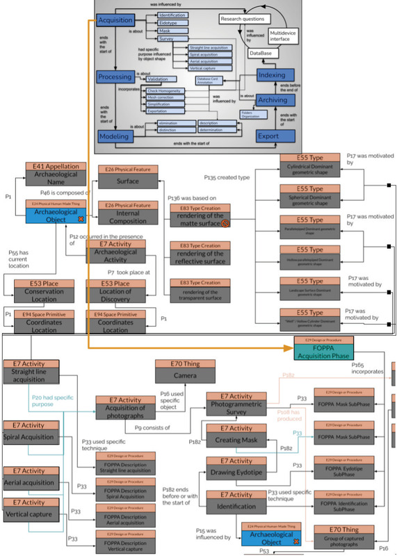
This study addresses the standardization of methodologies and data formats used in photogrammetric projects related to archaeology. The application of photogrammetry in recording and safeguarding cultural artifacts proves invaluable in various domains. However, the lack of a standardized method makes effective sharing of experiences and knowledge among practitioners difficult. This paper presents a methodological framework for photogrammetric data acquisition in the context of cultural heritage. This framework transcends the constraint of specific technical tools, embracing instead a level of abstraction consistent with the general principles of the Digital Data Curation paradigm and ontological encoding through the CIDOC-CRM model. Eventually, we provide a comparison between the FOPPA protocol with other three main acquisition protocols in order to test the interlingua that can enhance the communication between protocols. The overall goal of our research is to support systematic and methodical structured acquisition path, as well as systematic classification of metadata, facilitating the effective implementation of the methodology in new projects and promoting effective communication among existing projects.