Designing a database to fit the needs of an archaeological excavation meant creating an open architecture capable of adapting to the evolving aspects of our research project (in range of data as well as in level of detail); this, together with the complete integration within the global system developed at our Laboratory, were the first aims we pursued in building our solution. The DBMS, based on an open ID system, can be considered a large data container which is continuously updated in its structure; it allows us to easily build relational indexes, increase the level of data detail and create new table and forms in order to manage new types of data. Essential aspects of this solution are total control over data consistency and data vocabularies, a self-made and user-friendly interface, and the possibility of managing multiple projects together. The automation of many repetitive tasks through programming also helps archaeologists in elaborating their data in order to produce information (the elaborated finds quantification and frequency routines are a good example).
L’applicazione di nuove tecnologie in archeologia ed in generale nell’ambito dei beni culturali è un settore in continuo sviluppo ormai da molti anni. Sono moltissimi i convegni e le riviste dedicate alla sperimentazione di nuove strumentazioni, nuovi software e nuove tecniche che, provenienti per lo più dal campo dell’ingegneria o dell’architettura, sono impiegate in settori legati alla ricerca archeologica e in particolare alla documentazione e all’archiviazione dei dati (Curci, Fiorini 2012). Il nostro Dipartimento negli ultimi anni ha investito molte energie soprattutto nell’ambito della documentazione 3D di contesti archeologici di diversi periodi cronologici (Curci 2013, Fiorini 2012a) e per la prima volta ha avviato tali attività in un contesto di scavo paleolitico. Piante, sezioni e prospetti rientrano nella normale documentazione analitica di ogni scavo stratigrafico. Il disegno manuale è però caratterizzato da una forte componente di soggettività e da un consistente apporto di schematizzazione formale. Con il rilievo manuale, inoltre, non è possibile registrare in modo esaustivo la componente tridimensionale di strati e manufatti archeologici. Oggi, grazie all’evoluzione dell’informatica, è possibile superare questi limiti adottando un rapido e potente mezzo di documentazione: la modellazione tridimensionale. Con questa tecnica si ottengono copie percettivamente isomorfe dell’oggetto, dal quale si possono ricavare le quote di qualsiasi punto della sua superficie, i profili (piante, sezioni e prospetti) e le ortofoto (per ricavare informazioni dimensionali e disegni). Nel sito di Uluzzo (Fig. 1), che è diretto da Enza Elena Spinapolice (Università di Roma “La Sapienza”) in collaborazione con Stefano Benazzi (Università di Bologna, Dipartimento di Beni Culturali) e chi scrive (Università di Bologna, Dipartimento di Storia Culture Civiltà), il deposito archeologico e il suo contesto sono stati modellati con Agisoft PhotoScan a partire da immagini fotografiche acquisite sul campo con un’asta telescopica oppure a mano libera (Fig. 2). Ma non è tutto. Il contesto archeologico è costituito da una massa di informazioni connesse da reti di complesse relazioni spaziali e semantiche, che solo con una ricerca appropriata possono essere individuate, descritte, codificate ed utilizzate nella fase di interpretazione (Cattani, Fiorini 2004). Pertanto, è indispensabile operare una documentazione sempre più sofisticata del contesto archeologico e controllare questa enorme quantità di dati tramite una piattaforma GIS. A Uluzzo i dati di scavo, compresi i modelli 3D, sono stati archiviati all’interno del software Esri ArcGIS. Per quanto riguarda gli strumenti per la registrazione dei dati sul campo, oltre ai tradizionali supporti cartacei, si è fatto un largo utilizzo di tablet PC (Apple iPad Pro). Questo dispositivo è stato utilizzato a supporto di varie attività, in particolare rilevamenti topografici, fotogrammetrici e stratigrafici. Utilissimo, ad esempio, per annotare direttamente sulle immagini i perimetri delle US e i punti misurati con la Total Station (Fiorini 2012b).
La Galassina di Castelvetro (Modena) è un piccolo sepolcreto etrusco comprendente 37 tombe databili tra la fine del villanoviano e il V secolo a.C., pubblicato da Celestino Cavedoni e Arsenio Crespellani in seguito agli scavi effettuati nel 1841 e nel 1879-1880. Lo studio costituisce un’analisi completa del contesto funerario, a partire dall’esame della documentazione di scavo manoscritta e dei materiali, molti dei quali finora inediti, fino alla contestualizzazione topografica e territoriale della necropoli e del centro etrusco a cui va riferita, individuato al di sotto dell’attuale centro storico di Castelvetro. I dati emersi dallo studio del sepolcreto permettono di ricostruire non solo i vari aspetti dell’organizzazione dello spazio e del rito funerario, ma anche una capacità inattesa di esprimere il ruolo sociale e le credenze dei defunti.
Dal 2015 l’Università di Padova ha avviato una serie di campagne di scavo e di prospezioni geofisiche ad Aquileia nell’area archeologica dei fondi ex Comelli-Moro, grazie alle quali è stato possibile stabilire con precisione l’esatta ubicazione del teatro romano e conoscere le fasi di vita successive al suo utilizzo originario. In questo contributo verranno presentati alcuni risultati preliminari riferibili alla fase di rioccupazione dell’antico edificio romano. In particolare, grazie ad un approccio multidisciplinare, è stato possibile documentare alcune strutture pirotecnologiche e indicatori riferibili alla lavorazione secondaria del ferro (secondary smithing) localizzati all’interno di alcuni vani sostruttivi. Allo stato attuale delle ricerche è certo che questa rioccupazione artigianale non sia “episodica” ma che si sia prolungata nel tempo, e che si debba collocare in età tardoantica, senza però poter ancora giungere a precisazioni cronologiche puntuali. In futuro, grazie alla prosecuzione dello scavo e dello studio delle evidenze si potranno ricavare interessanti spunti di riflessione mettendo in relazione le attestazioni del teatro con le vicende storico-archeologiche dello stesso impianto urbano aquileiese, caratterizzate in questa fase da vari fenomeni di destrutturazione alla base dello sviluppo della futura città altomedievale.
Lo straordinario sviluppo delle tecnologie a disposizione e l'espandersi del campo delle applicazioni specifiche hanno imposto, nell'ambito del rilievo, un nuovo metodo di gestione della complessità dei dati che emergono dall'approccio scientifico con la realtà dell'architettura e della città, sia storica sia contemporanea. Attraverso un percorso che parte dal disegno per arrivare alle metodologie operative del rilievo, questo testo risponde alla necessità di affrontare da un punto di vista didattico le problematiche nate dall'evoluzione della disciplina in questa direzione. Grazie alla decennale esperienza didattica degli autori, il "Manuale di rilievo architettonico e urbano" è quindi uno strumento utile agli studenti che vengono guidati e accompagnati nello studio di questa disciplina.
Reconstructing the development of architectural complexes throughout time is often very difficult. Buildings are usually a series of constructive actions, changes from the original project, and collapses and reconstructions due to human actions (such as demolitions) and/or natural disasters (earthquakes, floods, etc.). The building’s structure records all these events, and by using a relief map gives us the chance to understand and decode them. The archaeological relief map is thus supposed to offer a complete and concise documentation. At the same time, it must be enriched with the additional information needed for a more detailed analysis of the archaeological object itself. In the last few years, the introduction and continuous improvements of many instruments (e.g. laser scanners and photogrammetric technologies) have led to a significant qualitative and quantitative change in the recording of material structures. In particular, the possibility of combining different relief technologies - obtaining high resolution, 3D geometrically correct models of buildings or of entire archaeological sites (which could be further investigated thanks to archaeological analysis or other procedures) - has modified the archaeological approach towards the material ‘datum’ and its divulgation. In order to acquire a better knowledge of contemporary technologies, the dissemination of different methodologies - through their application in research contexts - is the best way to transmit and compare them. This article is dedicated to the presentation and detailed analysis of a photogrammetric RGB point-clouds technology, used for the relief of a room during the archaeological excavation at Aiano-Torraccia di Chiusi (San Gimignano, Siena).
This paper deals with the practical application of photogrammetry in the study of the Roman city of Doclea in Montenegro, with particular reference to the use of Structure from Motion (SfM) techniques. Among the various research areas, archaeology of architecture and settlement archaeology make today an increasing use of photogrammetry for the in-field documentation of archaeological features. This method has an essential role in obtaining a reliable geometric survey that in turn forms the basis for the structural assessment of the architectural heritage thanks to consolidated methods such as archaeological stratigraphy and direct examination. In recent years, digital photogrammetry and the implementation of data processing technologies have made it possible to create three-dimensional models using images acquired through high-definition cameras. In addition to an accurate topographical survey, the aforementioned methods offer the opportunity to obtain a faithful representation of the real world, providing a basis for subsequent architectural and territorial studies. The use of drones equipped with cameras has proved to be particularly effective and capable of detecting large areas quickly and with good results. Due to its versatility and relative ease of use, photogrammetry could actually be deemed as an essential tool for the study and conservation of cultural heritage.
The need for a quick methodology of 3D surface recording, sensitive to the timing of fieldwork, low cost, and suitable for both micro- and meso-contexts, has induced the writers to develop a standard procedure. It is now possible to obtain a dense x, y, z point cloud starting from the photographic coverage of a surface, respecting precise parameters of overlapping for the different photos picturing the scene, and calibrating the camera. The software used to generate the point cloud is PhotoModeler Scanner, chosen firstly for its internal module of camera calibration and correction algorithm of radial distortion, and secondly for its capacity to verify the position of the different frames and point clouds roto-translating in a known reference system. The key point of the procedure is the importing of the point cloud in a GIS environment, where a DEM is created with an interpolation algorithm. The resulting surface is in the same GIS environment of vector and raster themes documenting the excavation. The procedure was tested in two different case studies: a micro-context corresponding to Tomb 112, a cremation tomb in the Iron Age necropolis of Piovego (Padua, Italy), and a meso-context corresponding to the Late Bronze Age settlement of Gradiscje (Codroipo, Italy). In both cases, meaningful because different in scale stratigraphy and survey issues, it is clear how 3D survey and the subsequent modeling of the point cloud has been fundamental for the understanding of the archaeological record.
Ghoufi is located in the Aurès Valley, near the ‘Oued El Abiod’. Its location, next to the panoramic road RN31, is referred to as ‘Balcon de Ghoufi’ because - from above - you can perceive the depth of the canyon (500/1200 m) and the beauty of the place, scattered with Berber villages (vernacular semitrogloditic architecture), terracing, water collection systems, palm groves, orchards and gardens. The Aurès Valley - a thoroughfare since ancient times, a caravan route between the desert and the Mediterranean Sea - has been the subject of archaeological explorations by Pierre Morizot since 1957-1962, which established the chronology of the settlements. This valuable work has been supplemented by ongoing research. This territory still retains the morphological and hydrographic peculiarities that justify the Berber settlement choice despite the fact that unfortunately the places have been abandoned following a recent flood. From 2016 activities of survey and research, directed by the University Badji Mokhtar of Annaba and the Polytechnic of Milan resumed at Ghoufi. These activities are aimed in particular at surveying archaeological and architectural artefacts, conservation interventions to address deterioration and instability and valorisation projects. Since 2017 the research has been funded by the MAECI. The project begun with the collection of documentation and knowledge of the Ghoufi site in a GIS environment. It prefigured a preliminary scenario for its conservation and reuse, following an approach of archaeological sustainability respectful of the characteristics of the site, the territory and the Country.
This research analyses deposits of Roman amphorae, in order to individuate the trade, exchange of goods and economic-productive aspects of Patavium and its surroundings. The discovery of more than two thousand containers gives a good numerical base and an interesting starting point for the study of food stuffs. Those amphorae are used to reclaim land since the second half of the first century BC to all the first century AD The combined analysis of typological facts, of excavation context and of the materials allows the division of the land reclamation into three phases: the first between the second half-end of the first century BC and the beginning of the first century AD; the second in the first half of first century AD; the third in the second half-end of the first century AD The market in the first two phases seems to be dominated by Italic products with a variation: in the second phase the oil quantity increases and reaches almost the half of the traded amount, whereas the quantity of wine is reduced, differing with the oriental contribution. The relations with far regions are consolidated with the trade of food stuff, such as garum. Third phase is characterised by supplies of local wine of different qualities, especially oriental, and by a huge use of oil.
In every region of the world there are some areas that assume an important role for cultural change and development of the neighbouring regions. This was the case of the Belice Valley in Sicily: its primary role in cultural change was the product of its long running in North-East/South-West direction that cuts almost all of Sicily from North to South, connecting the Tirrenian Sea with the African Sea. This preliminary study concerns the project “The Belice Valley: early cultural development in the Mediterranean area”, carried out in order to analyse the archaeological landscape on the basis of the socio-economic activities in pre-defined archaic societies. In order to process this complex information, we have started to undertake GIS and remote sensing applications reconstructing 3D models of the valley from macro-scale (territory) to micro-scale (sites). Finally, with virtual interactive navigation through the archaeological landscapes, we have created cognitive models of archaeological information that may hopefully also be useful for planning new archaeological parks.
CThe “Giunone” project concerns the implementation of a numismatical database, designed to become a valid tool for researchers in the field of numismatics and coin collection history. The database was built in conformity with the entity-relationship model and is used in this phase under a Unix System. The task of data entry can be carried out by different people using a programme that works on IBM computers.
The CAIE project aims to create a database collecting all the Etruscan monuments with inscriptions and to give, at the same time, critical importance not only at the text but also at the extra-linguistic context (i.e. elements regarding the origin and characteristics of the inscribed object, graphic peculiarities etc.). The purpose is a new and complex collection of Etruscan texts which, taking advantage of the power of computer databases, can deal at the same time with both information about the monument and its inscriptions; therefore, the program FUL/TEXT has been chosen, as an Information Retrieval System, duly adapted to the graphic particularities of the Etruscan language. At present about 5000 out of 10,000 so far known documents have been already recorded on file.
The BIBLOS project was established in 1996 for the purpose of creating an Internet site which would combine and organise all the information gathered by the various branches of the CNR (National Research Council) relating to the Humanities. The browsing system is based on a subject catalogue which represents the main access to the files, and which includes information on three different research topics: linguistics, philosophy and antiquities. The Institutes have already made available the information collected from their research activity and the databases which have been developed, usually in the form of bibliographic catalogues and specialised bibliographies. Querying the BIBLOS site, the user may also consult on-line the catalogue of the Massimo Pallottino Library which is part of the G. Marconi Central Library of the CNR and is located at the Istituto per l’Archeologia Etrusco-Italica. Computer access to the catalogue now makes it possible to consult the different sections of the Library, to gain access to the document delivery service and to activate the link with the Central Library of the CNR.
The ARGOS (Archaelogical Greek On-line System) Project proposes to create the most comprehensive bibliography on ancient Mediterranean civilizations and their cultural heritage, through a computerized union catalogue of the archaeological Libraries of the Institutions, foreign and Greek, in Athens. Their joint holdings, amounting to over 500,000 volumes covering the full range of Hellenic studies of all periods, including language, literature and thought, archaeology and history of art, ancient, medieval and modern history, topography, ethnology and folklore, are the most important in this field and are of world interest. By so linking these Libraries, we will make Athens the capital of learning in Mediterranean studies, effectively a new Alexandria. In addition, bibliographic information on articles published in journals and collective works will supplement the database of books. Readers in each Library will have direct access to the entire database, using multilingual menus and a detailed subject thesaurus to learn of bibliography and to locate the Library in which it is held.
The ARCTOS project (Visualization and Virtual Reality methodologies for a cognitive system on a archaeological Sicilian pattern) has been carried out by CINECA (Interuniversity Consortium for Supercomputing Applications) and the Scuola Normale Superiore (Pisa, Laboratory of Ancient Topography) with the support of IBM SEMEA, in order to study the archaeological site of Rocca di Entella (Palermo). This is an important archaeological multistratified site dating back to the Neolithic through to the medieval period; in particular, 13 archaeological areas have been investigated in the last years. Rocca di Entella can be described as a separate geomorphological space 60 ha wide; for every chronological phase the structures discovered show different features, such as buildings, materials, functions and uses. To analyse these complex layers of information, data was processed in 2D and 3D format so as to visualize the scientific content; in particular, it was important to allow the users to move in real time into virtual spaces, such as archaeological landscapes. We think that interactive 3D perception is fundamental for our cognitive system as it allows us to understand all the features of the archaeological landscape and the inter- and intra-site relationships.
In the last few decades, urban archaeology in Naples has contributed to outline the history of the city. The discovery of a great amount of pottery gave information about the daily life of ancient Naples. It was therefore decided to draw up a thematic archaeological map of the ceramics finds to reconstruct their production and distribution from the 4th century B.C. to the 7th century A.D. The project ceraNEApolis consists of a pottery map linked to a bibliographic database, which will be made available online: a working tool for experts, useful to outline the cultural city stratification and to understand the Neapolitan archaeological sites through the material. It is useful in defining the topography of production (workshop, raw materials, and resources), distribution (communication routes, harbour, market), uses and consumption patterns (house, habitat, sacred areas, burials) in the city, even if lacking monumental evidence. It contributes to the reconstruction and analysis of the cultural and urban landscape, taking into account the geomorphological elements and the data contexts even in diachronic and transversal multi-disciplinary perspective. The analysis of some significant cases shows its validity also for potential alternative fruition. The integration of virtual reality systems is a possible extension also for the knowledge, enhancement, communication and use of cultural heritage.
Il tratto urbano della Via Appia a Roma, breve, ma carico di storia, entrò a far parte della città solo con la cinta di Aureliano. L'archeologia di un paesaggio urbano, tanto spesso evocato quanto poco studiato, ci racconta una storia che dalla più remota antichità giunge sino alle odierne trasformazioni indotte dal cambio delle destinazioni d'uso e della sociologia della residenza, dalle vigne alle ville alle ambasciate. Il volume raccoglie gli atti di un seminario svolto presso l'Ateneo di Roma Tre e il Museo Nazionale Romano nel 2009. Gli interventi affrontano tematiche diverse, puntuali o generali, che mettono a fuoco la stratificazione storica di questo settore urbano e del suo mutevole rapporto con Roma. La capacità dell'archeologia di guardare, quasi radiograficamente, nel corpo stesso della città, per scorgere ciò che c'era e non c'è più, o più non si vede, contribuisce alla percezione della attuale identità dinamica e complessa, che non dobbiamo mettere in cornice e ammirare come un quadro, ma imparare a vivere, sentendoci partecipi di una storia che continua, e che è al tempo
Etruria Meridionale: conoscenza: le coste, la pesca. Le acque interne: appunti di archeologia preistorica. Gli Etruschi e le sorgenti termali. Le rocce e le argille dell’Etruria meridionale. La flora e le risorse agricole. La fauna e l’allevamento. Il popolamento dell’Etruria Meridionale e le caratteristiche degli insediamenti tra l’età del Bronzo e l’età del Ferro. La malaria nell’Etruria Meridionale. Il Centro di catalogazione dei beni culturali della provincia di Viterbo. Discussione. Etruria Meridionale: conservazione: La conservazione dell’architettura in tufo. Metodologia della conservazione della pittura parietale. I restauri sulle tombe dipinte di Tarquinia: aspetti metodologici e primi risultati. Conservazione sullo scavo e restauro in laboratorio: alcuni recenti interventi. La tomba dei rilievi in Cerveteri: applicazione della metodologia climatica. Metodo sperimentale per l’analisi di alcuni aspetti conservativi connessi all’uso di trattamenti superficiali. Conservazione e fruizione: analisi ambientale sulla tomba dipinta di Tarquinia. La conservazione del paesaggio. Il laboratorio di restauro dell’amministrazione provinciale di Viterbo. Discussione. Etruria Meridionale: fruizione: Musei e zone archeologiche dalla conoscenza alla fruizione. La parte delle comunità locali. La parte delle associazioni. Gli itinerari archeologici. Turismo e cultura: aspetti e beni di un’unica realtà
In May 2012 in the historic center of Palermo, Sicily, thanks to the Fondazione Sicilia the Palazzo Branciforte was opened to the public after a long and costly restoration based on a project by the Italian architect Gae Aulenti (http://www.palazzobranciforte.it/). For the creation of this innovative cultural center, the University of Foggia was responsible for the execution of the archaeological museum project and the multimedia system, which is presented in this paper. The activities were conducted by a group of young experts from different fields with the assistance of researchers and technicians from the Laboratory of Digital Archaeology. The paper describes the production process of the multimedia system and the method used to create digital content for the cultural heritage that effectively uses a wide spectrum of normally underused skills and proposes an innovative approach to technologies, creativity and knowledge.
The Virtual Museum of the Upper Calore Valley is a website which allows visitors to travel in time and space through and have access to various information on monuments, towns, culture, history, wine and food of the Hirpinian territory. By accessing six fictional videos on characters drawn from local history, users can also experience a historical overview, from the Longobard invasion up to the Unification of Italy, through the troubled periods of the Kingdom of Naples. The project works by open source software for video editing, GIS elaboration, and image processing. The browsing platform is based on the earliest release of the Aton framework created by CNR ITABC for browsing large-scale geographical and architectural data, with advanced features for graphic rendering, stereoscopic view, online representation of complex geometry and resolution through powerful paging algorithms. Aton is compatible with every modern HTML5 multimedia standard and is a powerful tool for historical storytelling.
The project focusing on the upgrade of the New Archaeological Museum of Ugento was created in the framework of the collaboration between the Municipality of Ugento and the Institute of Cultural Heritage Sciences of the CNR. The primary goals of this project are to improve the physical, sensory, and cognitive accessibility of the museum collections and to guide visitors in discovering the region and its rich, millennia-long history. To achieve these goals, we have designed cognitive and experiential pathways incorporating various ICT technologies: from gaming to virtual or augmented reality experiences for an immersive engagement of cultural heritage, from tactile interfaces for visually impaired users to installations inspired by the ‘Cracking Art’ artistic movement. This paper presents in detail the project requirements, the implemented solutions, their validation, and the achieved results.
RTI is a photographic method that allows to enhance any unevenness on the surface of an object. In archaeology, the RTI method is used for various purposes, for instance, to study superficial markings on ceramic artefacts and to understand their possible causes (natural unevenness of the materials, manufacturing techniques, intended use). This article describes a research that has been conducted thanks to the RTI method on some ceramic artefacts dating back to the Bronze Age, from the village located in Via Ordiere, in Solarolo (RA). The research aims to test the limits of use of this instrument and its actual potential to give information on certain aspects of the production process of a ceramic artefact, such as the tools used to refine the surface (smoothing or polishing). Moreover, the RTI images have been tested as auxiliary tool for archaeological design of lithic artefacts from the same sites (arrowheads). The first part of the article is dedicated to the methodological aspects of the research: the processing chain, the tools and the time needed to complete each phase of the work. In the second part, the results of the research and the possible developments are discussed. The points of strength and the limits of this method are both summarised in the last section of the article.
The aim of this paper is to accurately and realistically describe the condition of the archives in which the documentation of excavations and, more in general, of the intervention related to archaeology in Italy should be kept. It is clear that, because of the backwardness of the regulations and the lack of personnel in the Archaeology Superintendencies, every project of data sharing and data advertising needs to start from an absolutely matter-of-fact evaluation of the state of affairs. Additionally, the author notes that the Bray-Franceschini reform, which separates Museums from the Archaeology Superintendencies, has worsened the situation adding cumbersome and almost insurmountable bureaucracy.
The paper presents the first results of the Cecilia Metella Project, at the ‘Parco dell’Appia Antica’. The prominent monument is dedicated to the noble Roman woman, whose life can only be deduced from what can be read from the epigraph carved in marble. Although the monument is probably the most famous and characteristic one of the regina viarum near the city, even today the knowledge of the mausoleum – at least from the point of view of digital acquisition and analysis of the graphic documentation – appears incomplete and therefore deserves to be deepening. The new technological frontiers and their integrated use in the field of cultural heritage allow scholars to have more accurate and complete tools at their disposal. These multidisciplinary applications make it possible to acquire, in a rapid and quick way, the physical and spatial dimension of very complex and stratified archaeological contexts such as the mausoleum of Cecilia Metella. In this context, the richness of the graphic evidence of the mausoleum allowed for in-depth comparative analyses regarding the iconographical documentation and its relationship with the physical monument acquired with modern survey techniques. This study therefore aims to update the state of the art of the tomb and to define a methodological protocol for the acquisition and critical analysis of the monument.
Since 2012 the Istituto di Studi sul Mediterraneo Antico - CNR has been conducting an interdisciplinary research programme at the Roman villa of Cottanello (RI). The results of these investigations have been published in a recent work (Pensabene, Sfameni 2017). This paper presents some new studies on the villa, related, in particular, to the development of a website created with the CMS Museo and Web. The implementation of the website gave the opportunity to expand the research on the architectural terracottas, that represent one of the most important and conspicuous groups of ancient material found during the excavations. In particular, the article presents the online database of terracottas, their three-dimensional graphic reconstruction and some archaeometric analysis. The paper provides also an overview on other residential contexts, in which similar decorative terracottas were found.
Il guerriero di Capestrano e le iscrizioni paleosabelliche, in «Pinna Vestinorum e il popolo dei Vestini» a cura di L. Franchi dell'Orto, Roma: L'Erma di Bretschneider 2011.
Archaeological investigations over the last thirty years in Pontecagnano, an important Etruscan-Campanian site about 70 km south of Naples, have brought to light an interesting archaeological context consisting of a large ancient site and an extended cemetery with more then 7000 graves, dating from the 9th to the 4th century BC The need to acquire, analyse and display this rich collection of data has given rise to the project, addressed to the application of a vector GIS to handle archaeological records from funerary contexts. This work consists in the elaboration of a powerful cartographical database, including the spatial location of graves and their attribute data. In this way it is possible to create and display thematic maps in order to trace a reconstruction of the social organisation of the ancient settlement through the patterns of development of the cemetery. Meanwhile the exact recording of the excavated areas in the digital cartography, superimposed on the topography of the modern Pontecagnano, allows us to have a complete, updated view of the operations, in order to define a new townplan and infrastructural projects in the local area. The package chosen for the full integration of conventional archaeological data with maps is Mapinfo, a desktop mapping software in use in archaeological computing applications. The information has been organized into three tables: burial data, paleobiological remains and grave-goods. These tables are linked to the digital cartography, structured according to different layers representing the ancient levels of the graves and the topography of the modern town. The project, involving numerous public agencies with different institutional aims, is designed to offer a single tool responding to different needs: scientific research, territorial management, running of a museum, townplanning and informing the public.
In this project was been created and implemented an archaeological GIS system, called PyArchInit, which allows to manage and organize data in one geodatabase with software (Mandolesi, Cocca 2013). Therefore the data organized, classified and themed allow quick management of archaeological data. These data analyzed and processed are made accessible through a system that allows webGIS sharing and publishing. The research is subdivided into two parts. The first part of research concerns the informatics aspect and this implements the second part of research: the archaeological aspect. The informatics aspect allow the management and communication of archaeological data. The second line of research, which concerns the archaeological aspect, takes as a case study the Grotta of Fumane. The first chapters of this work introduce the archaeoinformatics concept. Starting history of the studies in this area, through the role of information technology in archeology and motivating because make open source system adopted. These assumptions are necessary to understand the purpose of this research, especially in a time when technological development is strongly active. Probably at the end of this work, the system will be made subject to new technical changes that will lead to further changes and improvements in treatment, acquisition, management and analysis of data. The second part of this work instead describes the entire physical structure of PyArchInit. It then goes on to analyze the case study with the various issues from the point of view that statistics on stratigraphic elements analyzed. Finally it is important to stress that the statistical analysis and geostatistical performed experiments are considered from the point of view from both the informatics aspect and methodological/archaeological point of view, where the results are used to a greater understanding of the data and of the site that you analyze and also as a kit of basic documentation. These experiments are constantly changing in order to seek the best methodology to be adopted.
During the 2008-2009 season the Archaeological Superintendence of Emilia Romagna began an emergency archaeological excavation under the city of Bologna, very close to the complex of an Etruscan sanctuary attributed to the ancient city of Felsina. For the systematic management of all the mostly paper documentation gathered during the excavation an information system within the scope of GIS technology was planned and setup. At first , we focused our attention on data normalization; afterward, our attention was drawn to the advantages obtained by using GIS technology, which makes it possible for complex phenomena and spatial-temporal relations to be represented and analyzed at multiple levels, as well as acting as a support for objective interpretative evaluations. Using this system we were able to create thematic and chronological maps, and analyze all the intra-site phenomena. This project provides an effective example of how GIS technology can also be applied retrospectively, when the excavation has already been concluded and the data were recorded in the traditional way; it therefore represents a valuable instrument for implementing the knowledge of an archaeological context.
Between 1999 and 2001, as part of the project Archaeology of Volterra and its territory, excavation took place at a rural site of the Roman period, situated near the old village of Montegemoli (Pomarance, Pisa). For the systematic management of all the mainly paper documentation gathered during the various excavations (US records, records of finds, plans of strata, reliefs and sections, matrix, photographs, IGM cartography), an information system within the scope of GIS technology was planned and set up. The results achieved are presented in this work, with particular reference to the methodology followed. Moreover, attention is drawn to the advantages obtained by using GIS technology, which has enabled complex phenomena and spatial-temporal relations to be represented and analysed at a multiplicity of levels, as well as acting as a support for objective interpretative evaluations.
Il libro illustra il processo di realizzazione di un film, dalla formulazione dell'idea narrativa alla distribuzione del prodotto finito, attraverso le fasi di pre-produzione, produzione e post-produzione. Il ciclo del film viene ripercorso sia dal punto di vista tecnico-organizzativo, sia da quello estetico-creativo. Particolare attenzione è riservata alle tecniche della sceneggiatura, della regia e del montaggio.
Studies in historic urban sites are very important for the defence and conservation of monuments and to preserve buildings. In this context particular consideration has to be used to layer-object, that is submerged structures and what is adjacent. With modern tools for photogrammetry bearing we can have numerical cartography with topological entities; it offers the means for structural and spatial study of objects. This can be drawn from their context and returned in 3D after some inspections. Useful elements can be added to numerical-cartographic maps by digital orthoimages resulting in mapping and storage operations. Our software inputs four files: - a tiff file storing the orthoimage - an ascii file with .par extension (the aim of this extension, like the following ones, is only indicative) containing rotoscalotraslation coefficients - an ascii file with .dtm extension containing che (x-y-z) coordinates of some generic points - an ascii file with .brk extension containing the (x-y-z) coordinates of some break-line points. Fundamental characteristic of this software is the possibility of recording orthoimages with no loss of geometrical information. The implemented functions include the possibility of displaying the orthoimage on PC screen, zoom in and zoom out, showing the geographic coordinates (East, North) in real time, creating more layouts for drawing, calculating distance between polygons, lines or points, calculating areas and perimeters, showing the altitude (approximation), displaying a DTM (digital terrain model). The interface is very friendly. Now our goal is rendering this prototype independent from its development environment.
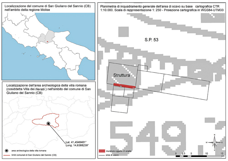
This article is the result of a research project currently being conducted at the University of Molise (Italy), aimed at drawing a cognitive framework of Roman building techniques in today’s Molise Region. The methods used to pursue this objective are specifically linked to masonry walls analysis, with an innovative interdisciplinary approach, entailing the use of a database, which is the result of the work of an international team of researchers (ACoR), in addition to the use of experimental methods to analyse the metric and the GIS platform to manage the geo-localization of the sites. Two different case studies are included in this paper, such as a Roman villa, i.e. a private building, in the municipality of San Giuliano del Sannio (CB), and a theatre, i.e. a public construction, in the municipality of Venafro (IS). Thanks to the different nature of the two examples, a different approach was used in analysing the parameters. For the private villa, the method employed was a stratigraphic reading of the structure, performed analytically; whereas for the public building, given its construction complexity being examined and the lack of results from the archaeological investigation, a sample method with metric parameter analysis was applied – already tested on the sites of Olimpia, Ostia and Cuma. The main aim is to contribute, through an extremely accurate analysis, filing, and geo-localization system, in the understanding of an area which is still under-researched and in which architectural information are extremely fragmented and little known.
The archaeology of standing buildings and archaeological survey are the essential prerequisite to properly investigate and interpret the evolution of historical buildings. Technological advances in recent years have led to an improvement in the methodologies and tools for three-dimensional survey and data analysis. However, so far, many of these tools and methods are not fully integrated in the archaeological practice, and their potential is only partially exploited. In some cases, technology becomes the goal and not the tool to answer research questions. Often, its implementation is only limited to documentation, while the analytical contribution is ignored. The article illustrates a method already well established in the research activities of the DHiLab laboratory of the CNR ISPC, which makes use of three-dimensional survey and visualization techniques as support tools for the analysis and interpretation of the medieval fortification of San Marino, including the three Towers and the city walls. The aim is to solve interpretative issues and answer complex research questions in order to better document and analyse the urban context and to reconstruct its architectural evolution in the late medieval and post-medieval periods.
This paper illustrates the usage and potential of the pyArchInit plugin, an open source tool created in Python language for the management and overall analysis of archaeological data on a single georeferenced platform (QGIS). Some of the functionalities of the application are highlighted in relation to the archaeological survey conducted in 2021 within the area of the Roman theater and the former Bosone spinning mill, in the historic center of Fano (PU), in the Marche region. Specifically, at the same time as the stratigraphic archaeological excavation operations were carried out, we proceeded directly on site, with the detailed management of both the identified stratigraphic Units and the finds recovered during the excavation, with direct data entry. In this way, it was possible to deliver to the Superintendence all georeferenced information layers in Gauss Boaga Est (EPSG3004) reference system, manageable in different GIS platforms and easily usable as a scientific research instrument for protection and planning of cultural heritage.
The paper presents and discusses results from the integration of various methods of geophysical prospection on the plateau between the Via Appia and the Via Ardeatina on the ancient suburb of Rome. The use of large-scale magnetometry, georadar and electromagnetic survey in an area of particularly dense archaeological remains is a highly effective methodology for revealing important information on previously unknown archaeological features. Of particular interest in this case is the comparison between geophysical data and the results of previous excavations, and newly-targeted test investigations that suggest the survival of the documented but previously undiscovered basilica of Pope Damasus as well as unknown catacomb tunnels at San Callisto and elsewhere on the plateau.