What is the use of reflecting on the history of Digital Archaeology? Dividing the history of Digital Humanities in general into four stages, Digital Archaeology was born in the stage of “pioneers’ applications” (1960-70), and for some time it developed both in practice and in theory. The theory seemed especially interesting also for non digital Archaeology, but around 1990 technology suffocated the more complicated and difficult theoretical approach. The opportunity to go back to this approach is demonstrated in three special cases: the creation of databases, the encoding procedures, and the relations between archaeology and information science.
The article illustrates the most recent achievements of archaeological computing, through a systematic survey that starts with the very name of the discipline, as used at national and international levels. The aim is to examine if the distinction made between 'archaeological computing' and 'digital archaeology' can really be helpful in framing the discipline in its theoretical and methodological evolution. From the synthesis made, the dominance of technological aspects on the theoretical and methodological approach clearly emerges. For some time now, technology has governed the three main areas of archaeological practice: field work, laboratory analysis and cultural heritage management and promotion. Two other important aspects are today rapidly gaining ground: 'Communicating archaeological research' and 'European digital infrastructures for archaeology'. Finally, particularly significant is the sector of Digital Heritage or Heritage Science, which today seems to be the focus of all digital archaeology involvements.
We propose new summary statistics quantifying several forms of dependence between points of different types in a multi-type spatial point pattern. These statistics are the multivariate counterparts of the J-function for point processes of a single type, introduced by Lieshout & Baddeley (1996). They are based on comparing distances from a type i point to either the nearest type j point or to the nearest point in the pattern regardless of type to these distances seen from an arbitrary point in space. Information about the range of interaction can also be inferred. Our statistics can be computed explicitly for a range of well-known multivariate point process models. Some applications to bivariate and trivariate data sets are presented as well.
This chapter presents some of the complexities involved in the use of independent dates in archaeology. The general model and its associated concepts specify the temporal, spatial, and relational loci of some of the many variables that constrain the applicability of such dates to past human behavioral events. Dating accuracy and relevance depend directly on the degree of control that archaeologists have over these variables. The general model and the principles that relate independent dates to the archaeological and behavioral matrices are designed to enhance this control. Nevertheless, this effort represents but a halting step toward the development of an adequate theory of the dating process in archaeology. The chapter discusses the need for such a theory and focuses on least one direction that the development of archaeological dating theory might take. Future development of archaeological dating theory will be directed toward improving the concepts and procedures used by archaeologists to relate independent dates to the systemic-level phenomena that are the ultimate concern of archaeological research.
The aim of this paper is to determine the degree of standardization within certain Late Roman pottery productions. This research tried to outline a methodology to determine the standardisation degree of these samples and to unravel the measurement systems used in the production process. The morphometric characterization of each fragment allowed us to create different groups with a cluster analysis. The principal component analysis provided information that led us to a deeper understanding of the obtained groups. The coefficient of variation allowed us to determine the standardisation degree of the productions. Once all these data are known, we can approach to the possible measurement units that ruled the analysed production systems. We selected a form well represented in the ceramic contexts identified in the excavations of the Late Antique port-canal of Classe, the Hayes 85 small bowl. This vessel was considered a rare form in Hayes’ monumental book. New discoveries of the last ten years revealed how much we still have to understand about the characteristics of Late Roman productions, trade and distribution. With this in mind, we used a statistical method to analyse the main changes in the profile of this type and its variants.
Visual tracking, in essence, deals with non-stationary image streams that change over time. While most existing algorithms are able to track objects well in controlled environments, they usually fail in the presence of significant variation of the object’s appearance or surrounding illumination. One reason for such failures is that many algorithms employ fixed appearance models of the target. Such models are trained using only appearance data available before tracking begins, which in practice limits the range of appearances that are modeled, and ignores the large volume of information (such as shape changes or specific lighting conditions) that becomes available during tracking. In this paper, we present a tracking method that incrementally learns a low-dimensional subspace representation, efficiently adapting online to changes in the appearance of the target. The model update, based on incremental algorithms for principal component analysis, includes two important features: a method for correctly updating the sample mean, and a forgetting factor to ensure less modeling power is expended fitting older observations. Both of these features contribute measurably to improving overall tracking performance. Numerous experiments demonstrate the effectiveness of the proposed tracking algorithm in indoor and outdoor environments where the target objects undergo large changes in pose, scale, and illumination.
Il volume ospita gli atti del convegno internazionale Incontrarsi al limite. Ibridazioni mediterranee nellItalia preromana, tenutosi a Ferrara dal 6 all8 giugno 2019 e dedicato a un filone di ricerca, i confini nel mondo classico, estremamente
This paper describes the objectives and methodological approaches of the project ‘IN-ROME – The INscribed city: urban structures and interaction in imperial ROME’. The project aims at mapping as comprehensively as possible a wide range of activities that shaped both the physical environment and the relationships between its inhabitants. Focussing on the time period between the 1 st century BCE and the 3<sup>rd</sup> century CE, and on the area outside the 4<sup>th</sup> century BCE ‘Servian’ Walls up to about the 9<sup>th</sup> mile of Rome’s consular roads, it draws on archaeological, literary and archival sources. In addition, and crucially, it aims to virtually re-contextualise c. 50,000 inscriptions in the Epigraphic Database Roma with a known provenance from the area, thus restoring agency to the archaeological landscape. To this end, a new webGIS is being developed that allows for the topographical visualisation of all relevant data.
Scholarship on the fourteen Augustan regions of Rome has tended to focus on their political and topographical significance. As a result, evidence for their social meaning and their impact on the mindsets and practices of the city’s administrators and rulers has been under-exploited. This article seeks to address this lacuna. It begins by reviewing the history of Rome’s regions and asking how and where the boundaries of the Augustan regions were recorded, before moving on to consider the impact of the regions on the Romans’ understanding and experiences of their city. This includes examining the evidence for bottom-up social identification with the regions, despite their top-down original creation. The paper also looks at the administrators who worked with the regions (regional magistrates and the food, water and fire services), arguing that the conceptual framework which the regions provided began to shape their working practices. Finally, it demonstrates the existence of a rhetoric of consistent provision across all fourteen regions, propagated especially by the emperors. The findings across all of these areas reveal that it is essential to take the regions and their impact into account when attempting to understand the topography of the city and the lives of its inhabitants. La ricerca accademica sulle quattordici regioni augustee di Roma ha teso a concentrarsi sul loro significato politico e topografico. Di conseguenza, le prove del loro significato sociale e del loro impatto sulle mentalità e sulle pratiche degli amministratori e dei governanti della città sono state sottoutilizzate. Il presente articolo cerca di affrontare questa lacuna. Si prendono le mosse esaminando la storia delle regioni di Roma, cercando di capire come e dove venissero registrati i confini delle regioni augustee, prima di passare a considerare l’impatto che le regioni stesse hanno avuto sulla comprensione e sulle esperienze che i romani ebbero della loro città. Ciò include l’esame dell’evidenza per un’identificazione sociale dal basso verso l’alto con le regioni, nonostante la loro creazione originale sia da intendere in senso opposto. Il contributo esamina anche gli amministratori che hanno avuto a che fare con le regioni (magistrati regionali e servizi alimentari, responsabili dei servi idraulici e antincendio), sostenendo che il quadro concettuale fornito dalle regioni ha modellato le loro pratiche di lavoro. Infine, dimostra l’esistenza di una retorica di disposizioni coerenti in tutte e quattordici le regioni, posta in essere e diffusa soprattutto dagli imperatori. I rinvenimenti in tutte queste aree rivelano che è essenziale tenere conto delle regioni e del loro impatto quando si cerca di comprendere la topografia della città e la vita dei suoi abitanti.
A UNESCO World Heritage Site, the 4th-Century CE Villa Romana del Casale near Piazza Armerina, Sicily contains the largest collection of mosaics in the Roman world. However, due to accessibility issues (e.g., remote location, weak online presence), the Villa remains nearly unknown in comparison to popular sites like Pompeii, despite its cultural importance. VILLAE, a collaboration between archaeologists, classicists, and game designers at the University of South Florida and the University of Arkansas, aims to build academic and public engagement with the Villa through a serious game played directly online using WebGL. Addressing the issues of accuracy in 3D reconstruction versus digital embodiment and meaningful game play, this paper outlines the project's pipeline for synthesizing the extensive 3D documentation of the site to create the digital prototype for an immersive narrative that unfolds the Villa's history against the development of modern archaeology in Italy and focuses the human story and professional life of a pioneering female archaeologist, Ersilia Caetani-Lovatelli.
The Digital Elevation Model (DEM), which represents the variation of elevation in a terrain at spatial level, is an important source of input to a variety of applications for deriving a number of terrain parameters such as relative relief, slope, aspect direction, profiles and cross-sections, earthwork and volume computations etc. In recent years, Synthetic Aperture Radar Interferometry (InSAR) has been viewed as a powerful approach to derive quality DEMs from a pair of SAR images. In this paper, the usefulness of the technique has been demonstrated for the generation of DEMs of two markedly different terrains, viz. plane and undulating. As the interferometry is often limited by the decorelation effects from thermal noise, temporal changes and baseline geometry, an adaptive filtering algorithm has been implemented and its effect assessed in reducing the phase noise and in improving the accuracy of phase unwrapping. The quality of the DEMs has been evaluated with known mean sea level elevations as derived from the topographical maps of the study areas. In plane areas, the RMS errors between the InSAR derived elevations and the map derived elevations was obtained as 7.9 m, which further improved to 6.2 m on application of adaptive filtering. Whereas, the RMSE values in case of undulating terrain was found to be 7.2 m on application of adaptive filtering. These results clearly demonstrate the usefulness of InSAR technique for generation of DEM at meter level accuracy, which is sufficient for many engineering applications.
On the mortar of a radial wall of the cavea of the Roman theatre in Aquileia, evidence of footwear with hobnailed soles was observed. This evidence, which was still fresh when the bricks were laid, took the form of an impression on the mortar. This is a significant finding from an archaeological perspective, as it can be directly linked to the construction phase of the theatre and, more specifically, to the activities of the workers who were active on the site. The objective of this study is to document and interpret the archaeological evidence using three-dimensional surveying methodologies, such as Structure from Motion and structured light system, for the analysis of the most significant impressions from a diagnostic and analytical perspective. This will firstly identify the type of footwear that left impressions on the mortar and secondly investigate the dynamics of the theatre’s building site, such as the number of people involved in the construction of the wall and their working areas.
Cultural heritage is the most important resource providing communication between the past and future. The societies utilizing this resource in the best way, have had an inventory of cultural heritage and contributed to world culture. The efforts made for being able to the accurate and healthy data in the documentation of cultural heritage led the new techniques to emerge other than documentation and, together with the developing technology, documentation with traditional method replaced with modern documentation techniques using new technological devices. One of these documentation techniques is the use of Unmanned Aerial Vehicles (UAVs) in the documentation studies. In this study, the usability of unmanned aerial vehicles in the studies of cultural heritage was studied.
The ever-increasing amount of remotely-sensed data pertaining to archaeology renders human-based analysis unfeasible, especially considering the expert knowledge required to correctly identify structures and objects in these type of data. Therefore, robust and reliable computer-based object detectors are needed, which can deal with the unique challenges of not only remotely-sensed data, but also of the archaeological detection task.In this research – across-domain collaboration between archaeology and computer science — the latest developments in object detection and Deep Learning — for both natural and satellite imagery — are used to develop an object detection approach, based on the YOLOv4 framework, and modified to the specific task of detecting archaeology in remotely-sensed LiDAR data from theVeluwe(the Netherlands). Experiments show that a general version of the YOLOv4 architecture outperforms current object detection workflows used in archaeology, while the modified version of YOLOv4, geared towards the archaeological task, reaches even higher performance. The research shows the potential and benefit of cross-domain collaboration, where expert knowledge from different research fields is used to create a more reliable detector.
New technologies, such as unmanned aerial vehicles (UAVs) and terrestrial laser scanning systems, provide opportunities for the digital documentation of cultural heritage. Although ultra-light drones (ULDs) are usually used for recreational activities, in this study, we examined their ability for use in digital documentation. We investigated the efficiency of an ULD for documentation of a selected historical building. In this study, the structure from motion (SfM) method was used to create three-dimensional point cloud data of a historical building using ULD and a low-cost UAV. The resulting point clouds were compared with terrestrial laser scanner data. The maximum standard deviations were calculated as 0.62 cm and 1.87 cm for low-cost UAV and ULD, respectively. The results show that ULDs can be used under suitable circumstances as a low-cost alternative for cultural heritage documentation.
The Center for Digital Geospatial Resources “Methodologies of Modelling for the Spatial Information Applied to Human Sciences and Society” (M2SIA– M2ISA) was created in March 2006 by the CNRS. The purpose is to facilitate the pooling, exchange, access, transmission, broadcasting, and mutualization of spatial data as well as respect the international geographical standards of the ISO/TC211 from a portal and from a geoportal. The CSDR M²SIA (CRN M²ISA) is constituted by ten partners who belong to the network of the MSH. This structure depends on multi-third party architecture in an open environment. One of the third parties of this architecture is formed by the suppliers of data who correspond to the various MSH sites. These sites give cartographic services created under the ArcIMS software with the AXL language. These services are automatically joined into the architecture and directly consumable by the simple user via an interface developed in Javascript, HTML. The AJAX and Web 2.0 technologies are implemented.
The project of incorporation and preliminary evaluation of a processing system for the description of pottery forms by means of the use of OMR and ICR devices is illustrated. This project, which has been implemented by the Laboratorio de Arqueoloxía of the Universidade de Vigo (Grupo de Investigación “Arqueoloxía Aplicada”), simplifies and speeds the recording of archaeological finds. The implementation of this type of system, applied in the analysis of finds coming from the Roman villa of Toralla, implies significant reduction in processing time of archaeological materials with the consequent advantages on the general process of investigation.
Recently, an interesting debate has developed in the context of historic archaeological disciplines concerning the employment of typical technical scientific methodologies and instruments utilized in research. The aim of this article is to contribute to this debate by showing how it is possible to conjointly utilize information technology techniques and statistical methods in archaeological research for both descriptive and interpretative purposes. The objective was successfully achieved by integrating several common spatial-statistical methods (Ripley's K-function) with the potential offered by GIS. In fact, the collection of files and graphical data representation was followed up by statistical data processing which, with the identification of several important parameters, has enabled GIS files to be improved with further information for subsequent processing.
The aim of this work is to contribute to a better understanding of the historical and archaeological heritage. Archaeological and territorial data have been collected and processed in a GIS in order to provide information on the evolution of the population settlement in a selected area used as a case study. The area investigated was that located between the rivers Nera and Aniene (North-South direction) and between the river Tiber and the Sabine Mountains (East-West direction). It is historically identified as the “Sabina Tiberina” region. This area is characterised by a large number of sequential settlements of different populations beginning in the Iron through to the Medieval period. The GIS developed offers the possibility of describing and interpreting the territorial changes caused by the various populations. One of the main features of the GIS is its easy use for non-expert users (such as teachers, students and decision makers). Examples of different types of maps that can be generated by our GIS are presented. Two examples of composite maps containing different types of information (geographical, historical, geological etc.) are presented to show the possibilities afforded by the system.
In recent years, the use of DGPS (Digital Ground Positioning System) satellite antennas has become widespread within the framework of the historical-topographic research. They give us the possibility of geo-referencing, in a simple manner, different objects spread across the territory, and permit the delimitation and geometrical survey of specific areas rendered in the shape of polygons. In the present project, new case-studies, aimed at defining new procedures for the geo-referencing of territorial elements, are produced. In these case-studies the use of DGPS, employed in a new and integrated way with other modern topographical instruments, has enabled us to survey complex structures and to produce detailed morphological studies of the sites. The archaeological sites that have been examined show great differences. Firstly, in their geomorphologic characteristics, the historical period, the cultural environment and related problems and secondly, for the different scale of the research, procedures and level of investigation of the archaeological research.
During the Roman period various military structures were build along the limes in the Lower Rhine Region. These military structures were connected with a road. This road has been excavated at various locations. One construction phase of the limes road and related structures was dendrochronologically dated to the autumn or winter of AD 124–125. This phase is probably related to a visit of emperor Hadrian to the region. The dendrochronological material of all contexts from this period shows a striking similarity of the tree ring patterns. This indicates that the wood came from a single region. This region is thought to have been located on the coarse soils between Xanten and Venlo. The timber was thus transported over a distance of approximately one hundred kilometres, making this the earliest example of large-scale long distance timber transport in the Lower Rhine region. The scale of the project justifies the assumption that the Roman state and army were involved. The oaks were most likely transported over water using barges. It should be noted that local wood was also used, indicating that the local woodlands were not yet depleted, but for this large-scale project the Roman army also had to look elsewhere for resources.
The work presents Agnano RiVive, an immersive Virtual Reality application developed to be used within the Museum of Preclassical Civilizations of the Southern Murgia in Ostuni, which preserves the findings of the Archaeological and Naturalistic Park of Santa Maria di Agnano. The application gives the user the possibility to explore the Upper Paleolithic settlement and interact with the old manufacts. The goal is to conduct the user to assist in the burial ritual of Ostuni 1, the world's oldest mother found in this site. A fundamental element is the paleoenvironment representation made possible by archaeobotanical studies. User experience was evaluated by submitting the Presence Questionnaire to 25 users. The results showed high levels of Involvement and Visual/Audio Fidelity and a strong correlation between them. Starting from this preliminary work, we propose to expand language and content to make the application educational and attractive to all types of Museum visitors.
The main target of the Sistan Project is the reconstruction of the prehistoric archaeological landscape, beginning from multispectral satellite data. In order to draw a new map (historical, cartographic and geological) of Southern Sistan, a TM image of Landsat 5 satellite was used, with a resolution of 28.5 mt per pixel, including 7 spectral bands. By comparing geological features with the position of archaeological sites in the prehistoric age, and processing this digital data, new information have been obtained and hypothesis proposed for the ancient population of the region. In particular, DTM (Digital Terrain Model) reconstruction, multispectral classification (raster data) and vector integration of data (archaeological sites, terraces, geomorphological features, contour levels), have allowed us to visualise a complex and dynamic model in 3 dimensions. For this aim virtual reality techniques (not immersive) have been used: on a workstation, the user can explore in 3D the landscape model in an interactive way, navigating through the digital data and choosing different perspectives and points of view. Moreover, it was also possible to process at the same time multidimensional information, such as the altimetrical model, unsupervised classification, natural spectral color, different spectral bands, vector data and so on.
The paper concerns the research activities of the IBAM-CNR and the IMAA-CNR in the field of archaeological remote sensing with the use of very high resolution images of QuickBird, the satellite with the greatest geometrical resolution available for civil use. These images have an enormous potential in the study of ancient urban and territorial contexts and for the identification and spatial characterization of archaeological sites, particularly when aerial photos and recent detailed maps are not available. During the archaeological research in Hierapolis of Phrygia (Turkey) and in southern Italy (Monte Irsi, Monte Serico, Jure Vetere and Metaponto), the examination and the study of panchromatic and multispectral images of QuickBird made it possible to detect surface anomalies and traces linked to ancient buried structures or to paleo-environmental elements; moreover, panchromatic images were georeferenced and used as the base field maps for the survey in Hierapolis, together with GPS systems. The satellite images were analysed both for the identification of archaeological features and for the characterisation of the contexts in which these elements were found. During field work, the traces and the anomalies identified in the images were constantly verified, so as to determine their actual relevance to archaeological elements, to interpret them and, where possible, to specify their chronology, thus avoiding misunderstandings and errors. The images were used in all phases of the research in combination with the aerial photographs and the available maps; they were also used for presentation of the results and were draped on DEM for the 3D visualization of the territories and of the archaeological features. In order to highlight particular archaeological traces and anomalies some image processing methodologies were adopted: multispectral processing and algorithms of data fusion (with the integration of the high spatial resolution of panchromatic images with the spectral capability of multispectral images), of enhancement (such as PCA, NDVI and TCT) and edge detection.
Imaging systems are the basic tools of the trade for art historians, conservators, and archaeologists, when they are called to document the results of their work. However, photo cameras and imaging systems are also powerful research tools. These systems, in fact, are inherently portable and give the possibility of acquiring high-resolution, spectrally resolved digital images that can be elaborated exploiting the most advanced algorithms of information science. In this contribution, we will outline the many possibilities opened by the available instrumentation and techniques, to suggest the use of image analysis as the first step of the diagnostic process in Cultural Heritage conservation and study.
Le mobilier de la tombe VT 128 de Spina (Italie) invite à réfléchir sur les rapports culturels d'Athènes avec sa clientèle étrusque. Dans ce mobilier de grand banquet on trouve soit des objets en bronze de Vulci, soit des vases attiques à figures rouges, dont la plupart a pu être conçue pour des acheteurs aussi bien athéniens qu'étrusques. Au contraire, le célèbre cratère inv. 2897 a l'air d'avoir été réalisé exprès pour un aristocrate étrusque, qui était lié à une divinité locale des Enfers vénérée par un rituel bacchique. Une telle divinité est documentée en Etrurie, au Ve siècle, par quelques inscriptions étrusques gravées sur des vases grecs provenant de fouilles anciennes ou récentes. L'évocation du banquet par les tombes de Spina et le renvoi explicite à un rituel bachique secret soulignent, par delà la proximité culturelle apparente avec l'Athènes classique, l'éloignement des deux cultures et leurs différences. The furniture of tomb VT 128 at Spina (Italy) is an invitation to examine Athens' cultural relationships with her Etruscan customers. In that furniture for a costly banquet are to be found either bronze artefacts from Vulci or red-figured Attic vases, most of which may have been wrought for Athenian as well as Etruscan purchasers. Conversely the celebrated crater i. 2897 seems to have been expressly made for an Etruscan aristocrat, connected to a local deity of the nether world honoured by a Bacchic ritual. Such a deity is documented in Vth century Etruria through a few Etruscan inscriptions engraved on Greek vases from ancient and recent excavations. The evocation of the banquet and the explicit ascription to a secret Bacchic ritual by the Spina tombs emphasizes, beyond near kinship, their cultural diversity in comparison with classical Athens.
In this paper we illustrate the use of cognitive metaphors for the transmission of historical and cultural contents as an indispensable condition in the process of museum communication. For this we used the 3D computer graphics animation to introduce the subjects dealt with in the exhibition spaces dedicated to Queen Nefertari, the chapel of Maya, the tomb of Kha, the house of the Golden Bracelet and the house of Octavius Quartio. In these filmed segments, passive viewing is offset by an emotional approach that engages visitors in an information path where, despite the inactive mode of fruition, they are in some way participants, because they are emotionally involved. The film itself is conceived as a showcase of changeable, heterogeneous digital content, capable to offer a concise, preparatory overview of the finds present in the museum spaces.
The recording and 3D modelling of complex archaeological sites is usually associated with high capital and logistical costs, because the data acquisition must be performed by specialists using expensive surveying sensors (i.e., terrestrial laser scanners, robotic total stations and/or ground-penetrating radar). This paper presents a novel, low-cost, user-friendly photogrammetric tool for generating high-resolution and scaled 3D models of complex sites. The results obtained with unmanned aerial vehicle (UAV) photogrammetry of an archaeological site indicate that this approach is semi-automatic, inexpensive and effective, and that it guarantees quality.
This study aimed at understanding the use of paintings outside of an art-related context, in the English version of Wikipedia.,For this investigation, the authors identified 8,104 paintings used in 10,008 articles of the English Wikipedia edition. The authors manually coded the topic of the article in question, documented the number of monthly average views and identified the originating museum. They analysed the use of images based on frequency of use, frequency of view, associated topics and location. Early in the analysis three distinct perspectives emerged: the readers of the online encyclopaedia, the editors of the articles and the museum organisations providing the painting images (directly or indirectly).,Wikipedia is a widely used online information resource where images of paintings serve as visual reference to illustrate articles, notably also beyond an art-related topic and where no alternative image is available – as in the case of historic portraits. Editors used paintings as illustration of the work itself or art-related movement, but also as illustration of past events, as alternative to photographs, as well as to represent a concept or technique. Images have been used to illustrate up to 76 articles, evidencing the polysemic nature of paintings. The authors conclude that images of paintings are highly valuable information sources, also beyond an art-related context. They also find that Wikipedia is an important dissemination channel for museum collections. While art-related articles contain greater number of paintings, these receive less views than non-art-related articles containing fewer paintings. Readers of all topics, predominantly history, science and geographic articles, viewed art pieces outside of an art context. Painting images in Wikipedia receive a much larger online audience than the physical painting does when compared to the number of museum onsite visitors. The authors’ results confirm the presence of a strong long-tail pattern in the frequency of image use (only 3% of painting images are used in a Wikipedia article), image view and museums represented, characteristic of network dynamics of the Internet.,While this is the first analysis of the complete collection of paintings in the English Wikipedia, the authors’ results are conservative as many paintings are not identified as such in Wikidata, used for automatic harvesting. Tools to analyse image view specifically are not yet available and user privacy is highly protected, limiting the disaggregation of user data. This study serves to document a lack of diversity in image availability for global online consumption, favouring well-known Western objects. At the same time, the study evidences the need to diversify the use of images to reflect a more global perspective, particularly where paintings are used to represent concepts of techniques.,Museums wanting to increase visibility can target the reuse of their collections in non-art-related articles, which received 88% of all views in the authors’ sample. Given the few museums collaborating with the Wikimedia Foundation and the apparent inefficiency resulting from leaving the use of paintings as illustration to the crowd, as only 3% of painting images are used, suggests further collaborative efforts to reposition museum content may be beneficial.,This paper highlights the reach of Wikipedia as information source, where museum content can be positioned to reach a greater user group beyond the usual museum visitor, in turn increasing visual and digital literacy.,This is the first study that documents the frequency of use and views, the topical use and the originating institution of “all the paintings” in the English Wikipedia edition.
In this contribution, we report on the image-based modeling (IBM) results of the Erechtheion monument, located inside the Acropolis of Athens, Greece. The work is part of the project "Development of Geographic Information Systems at the Acropolis of Athens". An aim of the project is the 3D documentation of the whole Acropolis, one of the major archaeological sites world-wide included in the UNESCO World Heritage list. The largest part of the monument was digitised with laser scanning, while the main objective of IBM was to model difficult-to- access areas not covered by the scanner but also for comparison with laser scanning for scientific investigations. For the 3D modeling, as the Erechtheion contains some typical architectural elements (like columns, flat walls, etc), some manual measurements were necessary. On the other hand, for some detailed areas automated approaches for dense surface reconstructions are applied. For these parts we compared the image matching results with the surfaces coming from a laser scanner.
The use of Textual Correspondence Analysis to investigate a corpus of iconographic compositions carved on Mesopotamian cylinder seals proved to be very useful to understand the peculiarities of the specimens from the points of view of geographic origin, typology and inner chronology. The presence of a relatively high number of rare forms in the data set – besides the hapax – led to think, however, that the extraction of the factors – so the outcomes of the analyses – could have been influenced heavily by them. For this reason, looking for an optimal composition and for the most effective encoding of the data set, a reduction of its rarest forms was performed to find the threshold which could allow to reconcile the need for keeping the useful encoded information with the best possible reduction of elements producing high inertia. Adopting the methodology known as Procrustes, the data table was thus progressively reduced, and each time investigated: the results so obtained were then used to reach a global assessment about how much each reduced data set could correspond to the optimized one.
In this paper we describe an application of image processing for the texture study of the use wear polishes on flint artifacts, experimentally obtained on two types of materials: wood and hide. The quantification of the textural properties of the images, obtained with a high magnification (200X) metallographic microscope strictly follows the rules indicated by HARALICK et al. in 1973. Twenty-two textural features were obtained from the image and statistical analysis then allowed the discrimination between the two classes of materials. The techniques employed, T-test and linear stepwise discriminant analysis, show that the discrimination between tools working wood and working hide is quite good, in the case of distance between the pixels = 1. Possibilities of future and more refined analyses are then discussed at the end of the paper.
Contemporary rock art researchers have a wide choice of 3D laser scanners available to them for recording stone surfaces and this is complimented by numerous software packages that are able to process point cloud data. Though ESRI’s ArcGIS primarily handles geographical data, it also offers the ability to visualise XYZ data from a stone surface. In this article the potential of ArcGIS for rock art research is explored by focusing on 3D data obtained from two panels of cup and ring marks found at Loups’s Hill, County Durham, England. A selection of methods commonly utilised in LiDAR studies, which enhance the identification of landscape features, are also conducted upon the rock panels, including DSM normalisation and raster data Principle Component Analysis (PCA). Collectively, the visualisations produced from these techniques facilitate the identification of the rock art motifs, but there are limitations to these enhancements that are also discussed.
This contribution proposes an evaluation of lidar and radar data processing and its potential in revealing archaeological features within a level plain environment, the southern lowland of Verona (Italy), focusing on evidences dating back to the Bronze Age. Many archaeological sites in the research area, including some of the most outstanding settlements of Terramare Culture, were identified or at least examined through aerial photo observation. Even if in several occasions modern agricultural activities contributed to the discoveries, bringing to the surface artifacts and scrapes of buried layers, this kind of impact has also been progressively deteriorating the archaeological record, hence the proto-historic landscape is now discernible through evanescent marks which cannot be always detected using customary optical sensors. Lidar and radar data analysis has then been considered as an alternative, non-invasive method of investigation on such a vast area.
Deep learning (DL) is a process that consists of a set of methods which classifies the raw data into meaningful information fed into the machine. DL performs classification tasks directly from sound, text, and images. One of the famous algorithms for classification of images in DL is convolutional neural networks (CNN). In this research, we tested DL model for image recognition using TensorFlow from Dockers software. We received 99% accurate to identify the test image. The system configuration used for this research includes Ubuntu 16.04, Python 2.7, TensorFlow 1.9, and Google image set (Fatkun Batch Download Image: Google, Google, chrome.google.com/webstore/detail/fatkun-batch-download-ima/nnjjahlikiabnchcpehcpkdeckfgnohf).
The development of the SITAR project took place in a time of new approaches in the management and use of archaeological geospatial data, even at the higher central levels of the Ministry of Cultural Heritage (MiBAC). SITAR represents an important technological and institutional challenge for the Special Superintendency for Archaeology in Rome, the governmental institution in charge of the safeguarding and exploitation of the Roman archaeological heritage. The aim of the SITAR project is the construction of the Archaeological Territorial Informative System of Rome for the management of the enormous and heterogeneous amount of data and for the multi-dimensional representation of the valuable historical context of a constantly evolving city like Rome. After a first phase of conceptual analysis, data model definition and taxonomic structures description, currently the technological development is focused on the SITAR project web platform and more specifically on the webGIS. The paper discusses the use of basic GIS functions integrated with specific tools for dynamic dataset multi-representation and web editing. These implementations allow all the users, both scholars and archaeology amateurs, to build their own new geospatial information; users now play an actual role in the system and in the enrichment of collective knowledge.
This paper analyzes first of all some inscriptions that attest to magistrates of a vicus acting on the basis of deliberations of the pagus of which it was part. This happens when public works deliberated and financed by the vicus concern somehow land
Questa Mostra nasce da un felice dialogo tra istituzioni museali ed enti di tutela che si sono confrontati e misurati nel difficile campo della comunicazione a un vasto pubblico dei saperi scientifici e dei risultati della ricerca: il Museo della Storia di Bologna, città la cui origine è etrusca, e il Museo Nazionale di Villa Giulia di Roma, il più importante museo della civiltà etrusca. Il gemellaggio tra queste istituzioni e la collaborazione con la Cattedra di Etruscologia dell’Università di Bologna hanno consentito di intraprendere un percorso condiviso, concretizzatosi in una duplice iniziativa: una mostra a Bologna e una a Roma, progettate unitariamente e virtualmente collegate per portare a Bologna capolavori del museo di Villa Giulia e, viceversa, far conoscere a Roma la realtà dell’Etruria Padana. Hanno contribuito a questo ambizioso progetto anche altre istituzioni, come il Museo Nazionale Archeologico di Tarquinia, il Museo Nazionale Archeologico Cerite, il Museo Civico Archeologico di Bologna e la Soprintendenza per i Beni Archeologici dell’Emilia-Romagna. Oltre ai consueti meccanismi di scambio delle opere tra musei, sono stati adottati sofisticati sistemi innovativi per riprodurre capolavori che non avrebbero mai potuto “viaggiare”, come il Sarcofago degli Sposi, emblema della civiltà etrusca, presente a Bologna in forma virtuale in un vero e proprio “spettacolo” che evoca il fascino dell’arte etrusca. In questa grande sfida si sono incontrati in uno straordinario dialogo, sotto il coordinamento di CINECA, esperti di tecnologie multimediali, di comunicazione e archeologi. E grazie a questo dialogo ha visto la luce anche un nuovo mediometraggio prodotto per il Museo di Villa Giulia, Ati alla scoperta di Veio , che inizia con il viaggio dell’etrusco Apa a Roma, il personaggio del mediometraggio proiettato a Bologna con grande successo e ormai entrato nel cuore dei visitatori di Palazzo Pepoli. Museo della Storia di Bologna.
Sull'onda del dibattito sugli «export models» nella ceramografia attica, il contributo cerca di dimostrare, attraverso l'esame dei vasi attici rinvenuti in Magna Grecia, l'esistenza di più «velocità» nella diffusione della imagerie ateniese. Una, ad esempio, legata a momenti di pericolo ο esaltazione nazionale (l'invasione persiana, la vittoria finale) vede immagini chiave come Athena, Zeus, Nike, la Gigantomachia, raggiungere l'Occidente in tempo reale, spinte dall'urgenza degli Ateniesi di comunicare le proprie difficoltà ο i propri successi. Una seconda e più ridotta velocità sembra, invece, riguardare la diffusione di immagini elaborate ad Atene sulla scia di fatti culturali, religiosi ο politici che non varcano i confini della polis. Almeno in due casi (Eros e Afrodite), che possono essere associati alla vita quotidiana, la maggiore ο minore «fortuna» del soggetto appare, infine, legata al grado di permeabilità della realtà socio-culturale del mercato di destinazione.
Morphologic and archeometric studies and quantitative analysis were carried out on the common ware pottery from the horrea located in the harbour quarter of Vada Volaterrana (S. Gaetano di Vada, Rosignano Marittimo, Livorno). It is attempted to define the functional, morphologic and technical characteristics of this ware, dated I-VIII cent. AD The relationship between common ware and the other kinds of ware (thin walled, Italian terra sigillata, African terra sigillata etc.) are studied. 64 different fabrics were identified; 65% of the common ware pottery was made on the Northern coast of Etruria; a considerable number of imports from Northern Africa and, in smaller quantities, from Central-Southern Italy and Eastern Mediterranean coasts were also identified. The pattern of trade and the local “Roman” production continued at least up until the end of the VI cent. AD The situation changed in the first half of the VII cent.: Mediterranean commercial trade ended and the local coarse ware pottery, very different from the traditional Roman pottery, became what is recognised as a protomedieval fabric.
Il valore dei gesti e degli oggetti. Monete e altri elementi in contesti funerari. Ediz. multilingue è un libro a cura di Noé Conejo Delgado pubblicato da All'Insegna del Giglio : acquista su IBS a 76.00€!
The article presents problems connected to the management of iconographic data using computer science tools. In particular, the authors discuss especially the computerised management of Athenian figure-decorated pottery which represents perhaps the most relevant set of iconographic patterns in classical antiquity. Up to now this pottery has been investigated by means of quantitative analyses to study in particular the mechanics of ancient trade in the Mediterranean basin because Athenian vases, from 6th to 4th century BC were widely exported all around this area. The computerisation of iconographic information, however, presents many difficulties: in fact archaeologists tend to express iconic information by means of linguistic sentences which are often inadequate; moreover there are still many problems about the correct interpretation of representations on attic pottery. On this subject, the authors illustrate a project on Athenian decorated pottery found at Spina, the Etruscan “emporion” of the Upper Adriatic, where the most impressive collection of Athenian decorated vases of the 5th century BC was discovered. A database has been created which collects data on 2132 clay decorated vases made in Athens: iconographic information is represented both with a description in natural language and by means of terms of a thesaurus conceived for this purpose. The database has also been explored through statistical analyses, such as Correspondence Analysis and Multidimensional Scaling, to find significative interrelationships between shapes and subjects, to identify associations between the different subjects represented on the same vase and to stress changes, as time passed, with regard to shapes and subjects.
L’anteprima di una delle indagini archeologiche più interessanti degli ultimi anni nella Capitale. Il tema è la via Flaminia antica al V miglio, in un tratto conservatosi miracolosamente integro sotto circa 7 metri di terreno e sigilli alluvionali depositati dalle esondazioni del vicinissimo Tevere. La circostanza del rinvenimento risulta particolarmente spettacolare in quanto l’antica via … Continue reading "Il mausoleo di Marco Nonio Macrino"
In this paper, the results of a scientific collaboration between the Institute of Etrusco-Italic Archaeology, the Institute of Technologies Applied to Cultural Heritage and the Civic Museum of Magliano Sabina are presented. The aim of this research is to study the distribution of archaeological sites in the territory of Magliano Sabina (Tiber Valley) and their relationship with the environmental-historical context. This area is a section of the Tiber Valley, where the river has always represented an important element from an historical point of view. In the present day in this area the river no longer follows its original course, so it was decided to find its old course in order to better understand the distribution of the ancient settlements in this territory. On the basis of research carried out at the Archivio di Stato di Roma it was possible to verify that the river Tiber originally flowed in the lower part of Magliano Sabina, nowadays the area of “Piana di Ramelli”. The study of historical cartography allowed us to verify the change of the river course since 1589, the year of the construction of the “Felice” bridge. The data has been confirmed by the morphological and geological characterisation of the selected study area. A GIS of the area has been used to compare and integrate all data sets with the aim of producing thematic maps to better understand the environmental evolution of the territory of Magliano Sabina.
La Missione Archeologica dell’Università di Bologna a Phoinike, antica capitale dell’Epiro, ha sempre affiancato alle indagini stratigrafiche dell’area urbana lo studio del territorio circostante. Di tutti questi studi si è sempre avuto cura di
The website Impero Romano e Intellettuali Greci presents a selection of texts by Greek authors from the first imperial age on the topic of the Roman Empire. Each of these texts is tagged to identify the most important issues concerning the empire of Rome. These tags provide electronic access to the most significant passages in which some of the most important Greek intellectuals living between the first and second centuries BC published and circulated their ideas about the Roman Empire. All of the passages are presented in the original Greek and are accompanied by an abstract in Italian in which the context and content of the passage are summarized. With the presentation of each passage the larger work from which it is cited is indicated, in addition to essential information regarding the dating of and the circumstances under which each work was composed.
Since 2016, the Montecorvino project has studied the topics of intervisibility and of the movement of humans and goods in the area of Monti Dauni (Foggia, South-Eastern Italy) in the late Middle Ages. This has been accomplished through the use of spatial analysis in an Open Source GIS. The use of Digital Terrain Models in a hilly area has been crucial in analyzing the influence of geo-morphological contexts on the genesis and development of settlements. Single and cumulative viewshed analyses have been applied to figure out if and to what extent these settlements could keep sight of each other, their surroundings and the communication routes. By means of a cost surface analysis, some site catchment areas have been defined and the potential and easiest (least costly) paths between some of these settlements have been generated. The results have then been integrated into a much wider research-field, which features archaeological, historical and bibliographical sources of information, to produce a comprehensive and integrated study of the ancient landscapes.
As Rome’s most notorious opponents on Italian soil, the Samnites have always occupied a special position in scholarship on ancient Italy and early Roman imperialism. The prominence of the Samnites in classical studies can be traced directly to Livy’s detailed account of the Samnite Wars. Writing centuries after the fact, Livy romantically portrays the Romans and Samnites as formidable opponents, and as almost evenly matched expansionist States. Consequently, scholars have propped up the ‘Samnite State’ by combining historical and archaeological data. However, historiographical research over the last few decades paints a different picture. Recent studies have questioned the historical role of ‘the Samnites’, and have indeed tended to deconstruct notions of strong Samnite socio-political cohesion and organizational capacity. The ultimate conclusions reached by some of the recent ‘deconstructivist’ studies are not yet uniformly accepted across different schools of thought. Especially the issues of a shared Samnite identity or socio-political organization, and the reality of Samnite military power and territorial expansion have become subject of a heated debate. However, these developing theoretical positions have remained partly isolated from a growing body of exciting new archaeological discoveries. To stimulate synergy, this volume brings together an international group of experts from different fields and backgrounds. It opens up the discussion by offering fresh viewpoints and new evidence for the political organization, social life, mountain settlement, cults and cult sites, and finally the character of Samnite and Roman expansionism.
Ideas and concepts of liminality have long shaped debates around the uses and practices of space in constructions of identity, particularly in relation to different forms of travel such as tourism, migration and pilgrimage, and the social, cultural and experiential landscapes associated with these and other mobilities. The ritual, performative and embodied geographies of borderzones, non-places, transitional spaces, or ‘spaces in-between’ are often discussed in terms of the liminal, yet there have been few attempts to problematize the concept, or to rethink how ideas of the liminal might find critical resonance with contemporary developments in the study of place, space and mobility.Liminal Landscapes fills this void by bringing together variety of new and emerging methodological approaches of liminality from varying disciplines to explore new theoretical perspectives on mobility, space and socio-cultural experience. By doing so, it offers new insight into contemporary questions about technology, surveillance, power, the city, and post-industrial modernity within the context of tourism and mobility. The book draws on a wide range of disciplinary approaches, including social anthropology, cultural geography, film, media and cultural studies, art and visual culture, and tourism studies. It brings together recent research from scholars with international reputations in the fields of tourism, mobility, landscape and place, alongside the work of emergent scholars who are developing new insights and perspectives in this area. This timely intervention is the first collection to offer an interdisciplinary account of the intersection between liminality and landscape in terms of space, place and identity. It therefore charts new directions in the study of liminal spaces and mobility practices and will be valuable reading for range of students, researchers and academics interested in this field.
Attraverso l’attualizzazione dei “Bacini Culturali” – quali spazi antropici e contenitori geografici di confronti culturali, azioni socio-economiche e processi di costruzione di identità collettive e individuali – ABACUS mira alla costruzione di una “comunità di interpretazione e conoscenza” delle realtà territoriali, socio-culturali ed economiche di riferimento dei Giovani siciliani, senza trascurare una opportuna prospettiva di sviluppo di linee di ricerca-azione a livello inter-regionale.
This paper presents the preliminary results of the Project T.Arc.H.N.A., Towards Archaeological Heritage New Accessibility, partially funded by the European Union, as part of the Culture 2000 Programme. Tarchna is the Etruscan name of the ancient city of Tarquinia and T.Arc.H.N.A. is the name of a model of the virtual Museum. Thanks to the use of modern technology, combined with a deep knowledge of history and archaeology, it has been possible to create a tool useful for both scholars and the wider public, which is also available for other situations. Through the cooperation of experts from two different fields – Computer Science and Archaeology – an innovative system of accessibility to the Cultural Heritage in the field of research, education and dissemination has been designed and implemented. One of the first results of the project is the restoration in its entirety of the original Tarquinian Heritage, much of which is scattered all over the world, lacking in contexts and anthropological meanings. Scholars are thus enabled to deal with this Cultural Heritage as a whole and to bring the single document from the environment that produced it, to the environment of the modern user, thus filling the gap between the document and its interpretation. In this way the public can learn the main features of the Etruscan culture and understand the research of scholars.
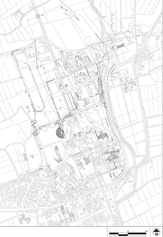
The SITAR project, designed to implement the GIS Archaeology of Rome, was started in 2007 by the Soprintendenza Speciale per i Beni Archeologici di Roma (SSBAR). The starting point for the SITAR project was the SSBAR requirement to digitize and manage a large quantity of administrative and scientific data concerning Cultural Heritage. This project was developed at a crucial point in which the Ministry for Cultural Heritage and Activities was rethinking the Territorial Information System, the data standardization and data sharing system used in the past decades. It was the input to the new institutional Open Approach. This aspect is apparent in the proposed SITAR data model, whose linearity is applied in the same basic logical levels already identified and well-structured information architecture of the System and those that will be tested. The additional advantage of SITAR is precisely the possibility of splitting archaeological knowledge into these core levels and reassembling it under the guidance of those who have the tools and scientific knowledge to do so. The SSBAR aspires to the creation of an archaeological ‘cadastre’ of Rome which is an approved and certified basis created according to information on legal and administrative aspects of archaeological science. In addition, the comparison with other institutions actively engaged in testing new multimedia technologies applied to cultural heritage has encouraged the evolution of SITAR to 3D data modeling and the development of procedures to test the archaeological potential.
The «Sistema Informativo Territoriale Archeologico di Parma» is a project promoted by the National Archaeological Museum of Parma in partnership with the «Centro di Geotecnologie» of the University of Siena, the municipality of Parma and the «Compagnia Generale di Ripreseaeree». The aim of the project was to create an archaeological resource management GIS, which would be useful both to archaeologists and to the municipality for city planning. The GIS was built with ESRI ArcInfo. The relational structure of its geo-database, managed with ArcCatalog, permits the use of a data model based on separate tables for the attributes of archaeological sites, associated archaeological investigations, and the data that constitutes the archive of the sites. The attribute tables are linked directly to spatial objects and base maps managed in ArcMap and provide the essential spatial search and query needed to manage the data effectively. The system is based on the 1:5.000 Regional Technical Map, that provides a spatial framework and information about roads, properties and administrative boundaries; it is integrated with aerial photographs and historical charts. This GIS consists of a spatial object that defines the location and/or boundaries of a broad range of data, from prehistoric sites to larger Roman and medieval structures. The associated attribute information for each of those sites is defined by the default thesauri, i.e. lists of preferred terms for describing types of archaeological sites. In the first step the study had concerned the old town centre of Parma; at this time the GIS holds nearly 400 archaeological sites and provides the main source of information about the archaeological excavations in the city. Some thematic maps of Parma have been created including a distribution map, chronological maps, an archaeological potential map. In the next phase the project will be extended to the whole municipal territory.
S.I.R.Be.C. is a multimedia project of Regione Lombardia. It began in 1993 and it is now carried out with the collaboration of twenty four museums, eleven Provinces and seven Dioceses. By the year 2000, the project aims at establishing: - a computerized inventory (data and images) of Lombardy's cultural property; - a regional information system of Lombardy's cultural property, consisting of a central multimedia data base, a regional computer network and a regional documentation centre; - a coordinate network of the documentation centres and the data bases belonging to museums, to public and private institutions and to the Church. S.I.R.Be.C. cooperates with the National Ministry for Cultural Property - Istituto Centrale per il Catalogo e la Documentazione I.C.C.D. and with police units aimed at repressing illicit traffic in cultural property.
The Sistema Informativo Archeologico di Roma Antica e del suo Territorio was created by the Sapienza University of Rome. The system was initially designed on a proprietary software platform. Its complexity stems from the fact that it included all the structures and the objects found in Rome within the Aurelian walls. A research team led by F.G. Cavallero assisted by G. De Rosa is dealing with the system migration to an open source software (QGIS and PostgreSQL/PostGIS). The difficulties encountered in this process and the strategies used to overcome them are the subject of this paper.