

Items
-
Academic ArticleUna tomba infantile della necropoli di Sasso Pizzuto di Tuscania in Mediterranea XVUna tomba infantile della necropoli di Sasso Pizzuto di Tuscania in Mediterranea XV, 2018, pp. 309-322.
-
Academic ArticleUna proposta di standard per l’archiviazione e la condivisione di dati stratigraficiArchaeological stratigraphy-datasets are widely represented and visualised by the Harris Matrix. However, even digital Harris matrices retain most of the limitations their paper originals experienced and they are still in need of a standardised format for automatic recording. This paper presents an example, based on the well-known CSV open format, with a Data Package descriptor. The Harris Matrix Data Package standard is the result of two independent software implementations, one in Common Lisp by T.S. Dye and one in Python. The proposed format is not limited to describing the stratigraphy for the sole purpose of generating a diagram to look at, but it can be used to model stratigraphy as a Directed Acyclic Graph and to guide the interpretative process and integrate the results with established procedures for Bayesian modelling.
-
Academic ArticleUna proposta di analisi GIS per la lettura degli assetti insediativi nell’Abruzzo interno tra l’età del Ferro e la romanizzazioneThis paper presents a territorial analysis focused on a sample area in the inner region of Abruzzo, delimited by the Gran Sasso and the Sirente mountain ranges and characterised by strong geomorphological irregularities. Archaeological data from the Final Bronze Age/ Early Iron Age to the beginning of the Romanization process are analysed through a computer-based approach, using CAD, DBMS and GIS. Published data about this region are quite disjointed, both for methodological reasons and for various interferences in the archaeological record. These aspects influenced the landscape analyses proposed in previous studies and the hypothesis about the territorial exploitation patterns during the pre-Roman times. Research has been mainly concentrated on sites with better visibility, such as fortified hilltop sites and necropolises, frequently compared to the Roman settlement pattern, based on valley floor sites along the main pathways. Nevertheless, recent surveys suggest that these data should be reconsidered, taking into account both the presence of other kinds of sites (such as the Iron Age/Archaic period small rural sites localised in the valley floor) and continuity in the settlement pattern up to Roman times. The available archaeological data have been processed within a GIS, in order to investigate placement and visibility/intervisibility factors in hilltop fortified sites, starting from an expressly projected DEM. The territorial sample has been filtered using qualitative and quantitative parameters, proving that hilltop sites during the pre-Roman times were likely to control the natural catchment area. In Roman times, this pattern lost its mainly defensive character, with hilltop sites being abandoned, and was incorporated in the so-called ‘paganus-vicanicus’ system, connected to the administrative subdivision gravitating on urban centres (coloniae and then municipia) and on new monumental cult places.
-
Academic ArticleUna nuova metodologia di archiviazione per una migliore gestione del patrimonio archeologicoThe procedures followed for the preparation of the thematic layers, describing the finding in an Etruscan site, are presented. The testimonial shows the advantages of using AutoCAD based tools, in order to link the database, containing the description of the objects in the drawing, to the CAD elements. This paper shows how to use the potential of a desktop GIS, based on AutoCAD and DBIV, in a variety of fields: from the preparation of hazard maps, showing the risk zones of fragile archaeological sites, to the preparation of a micro GIS project of fractures and related sections of a painting restoration project. The methodology proposed starts with the preparation of a topographic layer for the archiving of objects found on the site. The use of AutoCAD in conjunction with GDL-Graphic Data Link by Alpha Consult srl of Rome and ADE by AutoDesk is proposed, in order to simplify mapping of archaeological sites and perform relational queries on stored data. The AutoCAD application, called GDL/ARCHEO, is designed to establish and maintain DWG/DXF-DBF LINK, that can be utilized by ArcCAD (ARCINFO Data Structure), MAPINFO and INTERGRAPH. GDL/ARCHEO, a personalization of GDL is used as the data input environment for descriptive data related to AutoCAD featured in the drawing. The program has a library of Etruscan vases that can be further personalized and expanded; the default database can be modified to accommodate personalized projects. GDL/ARCHEO has the ability to create overlays, to assign ID-values to the resulting polygon, to provide network tracing capabilities and establish buffer areas for further studies. The program is an add-on ADE (AutoDesk Data Extension) for large archaeological sites. The paper also describes the GIS functions of overlay, buffer, polygon processing and network tracing to prepare hazard maps showing the risk analysis related to the different sites.
-
Academic ArticleUna nuova iscrizione peligna del gruppo “ana(a)c(e)ta”Una nuova iscrizione peligna del gruppo “ana(a)c(e)ta” (in collaborazione con M. Buonocore)
-
Book Section
-
Academic ArticleUna metodologia di microscavo e di documentazione al servizio della conservazioneIl microscavo può essere definito «la serie di operazioni di scavo stratigrafico e conservazione che si effettuano in laboratorio sui reperti contenuti in una porzione di deposito archeologico asportata in blocco dal terreno di giacitura.
-
Academic ArticleUna kotyle del Pittore di Bellerofonte di Egina e altre importazioni greche ed orientali dalla tomba 4 di Monte Abatone a CerveteriThe paper presents one of the most important complexes of the Orientalizing period in Caere (Ce’rve
-
Academic ArticleUna guida estesa a tutta l’Italia : il Touring Club Italiano e il progetto della segnaletica stradale, 1895-1939La segnaletica stradale svolge un ruolo informativo imprescindibile per consentire la mobilità delle persone. Si tratta di un intervento artificiale esteso, condiviso da fine Ottocento a livello internazionale, che ha tradotto la necessità di standardizzazione di segnali e supporti configurandosi, probabilmente, come il più diffuso repertorio pittogrammatico e letterale riconoscibile e decifrabile da miliardi di persone. L’Italia è fra i primi paesi al mondo a dotarsi di un sistema progettato a questo scopo grazie al Touring Club Ciclistico Italiano, che dal 1895 inizia a installare «speciali indicatori» lungo le strade della Penisola, con l’intenzione di fornire un servizio ai viaggiatori, una segnaletica adeguata alla velocità dei mezzi, ossia cartelli immediatamente riconoscibili e comprensibili a tutti, collocati in posti visibili, con scritte e segni leggibili da lontano e in condizioni disagevoli. Da allora, sostituendosi per lungo tempo alle competenze statali e grazie alle sottoscrizioni private, l’associazione partecipa alle iniziative che sanciscono le convenzioni fra Stati in materia, coordina e affianca gli interventi di enti e organizzazioni coinvolti, sollecita normative specifiche ma, soprattutto, si occupa di disegnare, produrre, decidere dove collocare e installare «i pali con cartelli indicatori» adeguandoli alle prescrizioni internazionali e proponendo, in alcuni casi, nuove soluzioni grafiche. L’articolo ricostruisce il ruolo e il contributo del Touring Club italiano nell’elaborazione, fino alle soglie del secondo conflitto bellico, di questo moderno caposaldo della comunicazione visiva che meriterebbe di essere inserito nelle storie del design più di alcune opere autoriali, essendo un sistema di artefatti industriali, di utilità pubblica, diffusissimo e destinato a una funzione indispensabile: garantire sicurezza, informazione e orientamento a tutti.
-
Academic ArticleUna esperienza e una proposta per lo studio delle anfore: il caso della tomba di Giulietta (Verona)Results of the archaeometric study of Spanish amphoras in Veneto are presented. For this purpose 26 amphoras from the Tomba di Giulietta in Verona were chosen (types close to Dr 7 and Dr 8). The scope of the analytical study was to determine similarities between clays and thus between the amphoras themselves. To conduct petrographic analysis, groups were set-up of Spanish amphoras of both types without determining relationships between various forms and clay bodies. North Italic amphoras were also considered for comparison. The most useful methods of statistical analysis of data of diffractometric analysis are “ipercubo” and Discriminant Analysis. Fuzzy and mixture methods were also used. Applying these methods, samples were compared in order to form groups of similar samples. Instrumental neutron activation analysis was carried out to determine trace elements and the results were processed with Discriminant Analysis. These results enabled us to make clear distinctions between various groups. Studies of these amphora forms are now under way.
-
Book Section
-
Academic ArticleUna banca dati di immagini su videodiscoThe article is addressed to the archaeologist, usually a “non expert” beneficiary of the innovative computer science techniques, but, at the same time, bearer of very complex requests. It proposes to give a concise and up to date view of the state of CAD software, especially as regards tridimensional graphics.
-
Academic ArticleUn’infrastruttura di ricerca per l’archeologia: il progetto ARIADNEARIADNE brings together and integrates existing archaeological research data infrastructures, so that researchers can use the various distributed datasets and new and powerful technologies as an integral component of the archaeological research methodology. ARIADNE is funded by the European Commission under the Community’s Seventh Framework Programme, contract no. FP7-INFRASTRUCTURES-2012-1-313193. The project started on 1st February 2013 and runs for 48 months.
-
Academic ArticleUn'introduzione all'ontologia DOLCEUn'introduzione all'ontologia DOLCE, Gaio, Silvia,Borgo, Stefano,Masolo, Claudio,Oltramari, Alessandro,Guarino, Nicola - AIDA
-
Academic ArticleUn'applicazione GIS per il sito archeologico di Villa Rufolo a RavelloThis paper describes a methodology for using the GIS Arc/Info system as an operating tool to study excavation finds and structures on an archaeological site. The choice of the archaeological sample site (Villa Rufolo, Ravello - Italy) and the definition of information and methodologies useful to its study and management were the result of collaboration between a photogrammetry partnership (S.F.M.) and the “N. Cilento” archaeological laboratory of the University of Salerno. The GIS architecture was developed starting from the analysis of methods common to both the research methodologies (landscape recognition and stratigraphic excavations), which define the phases of archaeological data manipulation. The main aim was to create a tool which, starting from the planimetric documentation of each excavation, could link the various environments to their related stratigraphic units through data derived both from the individual structures and from artefacts. Following Arc/Info data models, all information was arranged into a relational database. The Stratigraphic Unit (US) attribute forms the link which connects the graphical elements, geographical and spatial database, and the descriptive database. Data stored can be analysed using many criteria, and the GIS always makes it possible to display the graphic results of the analysis. Besides the management, integration and manipulation of the archaeological data assigned to the territory under investigation, with Arch/Info various data levels can be combined for the purpose of producing new types of information; this information is usually acquired by employing techniques of data overlapping and through statistic and classification processing of all the stratigraphic units related to the site. The next stage of our project will consist of a careful check of the results of the statistical and classification processes and the use of this model at other archaeological sites so as to exploit the GIS potential for comparing excavation data as well as the geomorphologic and geographic features of the various sites.
-
Academic ArticleUn'anfora frammentaria dalla Laguna di VeneziaIn this paper the authors have analyzed a fragmentary amphora found in the Venetian lagoon at Chiese Bruciate, which has analogies with another amphora from the lagoon which was found in the Rigà Canal. By comparing the amphorae on a typological basis it was found that they represent one of the least common shapes among the amphorae produced in the eastern Mediterranean which are known as the Late Roman type. Both of the amphorae discovered in the lagoon seem to have been imported from Asia Minor or the Aegean area of the Mediterranean during the Late Antique or Byzantine era. The amphora from Chiese Bruciate was attributed to the Late Roman 2 group and in particular to the Dyczek 25 type. As has been done in other study cases, along with the typological analysis a geometric shape study - i.e., a morphometric analysis of the amphorae made by comparing the different forms using geometric indexes calculated on the coordinates of the points measured on the outline of the vase - have also been conducted. Two known statistical indices were used: the coefficient r of Bravais Pearson and the similarity ratio k. For the analysis of the analogies between the shape of the amphora from Chiese Bruciate (SB) and the other amphorae open source R software was used.
-
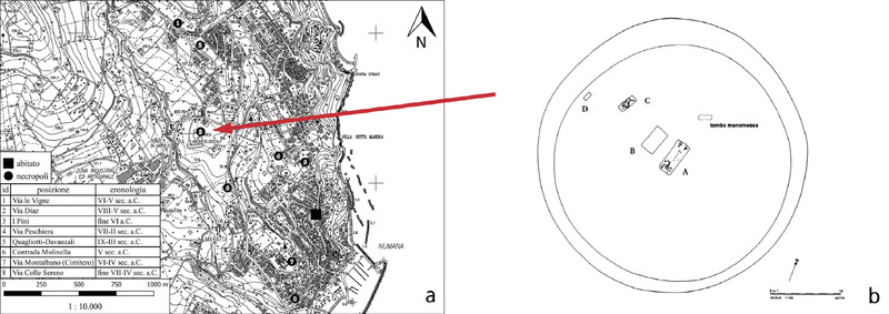 Academic ArticleUn Virtual Immersive movie per la fruizione del patrimonio archeologico: il viaggio nella “Tomba della Regina” di Sirolo-NumanaThe paper presents a workflow aimed at documenting, disseminating, and making archaeological heritage more accessible. To preserve scientific rigour and data accuracy, also providing an emotional experience to the audience, the entire process was carried out through the collaborative efforts of three professionals: the archaeologist, the digitization expert, and the entertainment industry professional. The case study is a pre-Roman necropolis located in the “I Pini” archaeological area (Marche Region, Italy). The site presents several circular burials, one of which belongs to a female figure known as the “Queen”, which became the central focus of the narrative. The first working step was the digital documentation of a selection of the findings from the “Queen’s” tomb, currently displayed at the Antiquarium Statale of Numana, followed by the virtual reconstruction of the burial. Then, the obtained 3D models were used to generate a Virtual Immersive Movie (VIM) which allows visitors to immerse themselves in the virtual reconstruction and interact with the archaeological findings using a Head-mounted Display. The evaluation of the user experience proved the effectiveness of the VIM. The scores obtained from the questionnaire will also serve as inspiration for further enhancements, aiming to deliver a more interactive and improved educational experience.
 -
Book Section
-
conference paper
-
Academic ArticleUn SIT per Entella (Comune di Contessa Entellina, PA)The aim of this project has been to create a GIS for the archaeological survey in Contessa Entellina (Palermo) that was conducted in 1998 by the Historic-Archaeological Topography Laboratory of the Scuola Normale Superiore in Pisa. The survey covered an area (about 42 km2) of the territory of Contessa Entellina. Like the survey, the GIS was also a model for research. During the survey Topographic Units (UT) were located with large concentrations of finds and other zones labelled “Sporadic Material” (MS) were also identified. The GIS includes only the Topographic Units. With the software ArcView GIS 3.1, UTs have been located as points on a raster map at a scale of 1:5000, the same as used for the survey. The survey data has been recorded in a relational database that holds information about the finds, the documents, the relationship between UTs, the chronology, the vegetation, etc. We focused our attention on the representation of temporal information. However, it is very difficult to represent archaeological dates in a database scheme because their limits are uncertain. Therefore, to represent this uncertainty every Topographic Unit is characterised by several periods. Each period has a beginning (field “Inizio”, meaning “Start”) and an ending (field “Fine”, meaning “End”). These two limits have a symmetrical tolerance (for example ±50 years). In the future, this system will be completed and used to analyse the spatial relations between UTs and their visibility.
-
BookUn sistema per la gestione dell'affidabilità e dell'interpretazione dei dati archeologici: percezione e potenzialità degli small finds il caso studio di Festòs e Haghia TriadaUn sistema per la gestione dell?affidabilità e dell?interpretazione dei dati archeologici' aims to identify the methodological problems associated with digitalized management of archaeological data and to introduce viable solutions that embrace interpretative aspects and the reliability concept. The work develops into a prototype system that manages the data regarding what are referred to as small finds dating back to the palatial periods from the Cretan sites of Phaistos and Ayia Triada which have been studied by the Italian Archaeological Mission since the early 20th century. 0The analysis of the data highlighted the value of this system and its ability to adapt to the needs of the archaeologist. It provides tools capable of assisting and implementing the interpretation of archaeological data well outside the findings and sites specific to this project for the management of other categories of archaeological finds and of any context. The book can furnish practical and theoretical contributions capable of feeding the methodological debate inherent in issues such as the treatment of sources, legacy data, reuse, the management of uncertainty, and of the rational and intuitive variables inherent in archaeological work, as well as the assessment of the reliability of an interpretative event
-
Academic ArticleUn sistema integrato per la gestione della cartografia e dei dati di scavoThis paper illustrates the computing section of a Strategic Project for the development of research methods applied to the study and safeguard of the archaeological heritage of southern Adriatic Italy. The project was launched by the Italian National Research Council and the University of Lecce. The computing section has as its objective the creation of a system for the management of data pertaining to antique settlements that guarantees the integration of three information supports: alphanumeric, cartographic and photographic. These supports contain data deriving from two interacting research systems: field survey and excavation. The cartographic data is varied: large scale maps, area and site plans, detailed plans of single monuments, stratigraphic sections and feature and layer plans. Software used consists of a relational database and a specific digitised mapping system. The system permits the acquisition of raster images. A global user-friendly interface which permits maximum navigation is in the process of completion. We foresee the principal field of application being the analysis of spatial distributions of artefacts and ecofacts as a basis for synchronic and diachronic cultural analysis.
-
Academic ArticleUn sistema informativo geografico per l’architettura vernacolare dei centri storici: dal modello dei dati alla diagnostica. Il caso di Cancellara (PZ)When attempting the recovery and reutilization of historic architecture, an in-depth knowledge of the artifact and its physical, environmental and historical context represents the first step required for its protection. Another important step is the choice of a methodology for transforming heterogeneous data into organized data. The aim of this research is to propose a method to construct a data map of the architectural heritage and the multidisciplinary aspects that qualify it (construction techniques and materials, material decay factors, signs of disastrous events in the past on buildings and the urban fabric, etc.). Thanks to the GIS environment it is possible to link together geometric, spatial and relational elements and then to develop quantitative and qualitative analyses based on spatial methods for typological and structural classification and to evaluate surfaces and structures. The design of the GIS architecture is fundamental, in order to contain data coming from different paths of knowledge acquisition (observed in loco or coming from documentary sources, derived from spatial analysis or instrumental investigations). In this way an important instrument for diagnostics, urban planning and conservation management can be created. The project is in its initial phase. The case study concerns the indigenous architecture of the historical center of Cancellara (PZ).
-
Academic ArticleUn sistema informativo archeologico: l'applicazione del Syslat a Fratte di SalernoSome years ago, the chair of Archaeology of the University of Salerno, in cooperation with the Soprintendenza Archeologica and the Amministrazione Provinciale, began a methodical research program on the ancient settlement of Fratte. This settlement is situated on the hill of Scigliato, in the north-eastern part of Salerno on the Irno River, at the confluence of the Pastorano and Grancano streams. Since 1985 the archaeological area - partly rediscovered in the 50’s and immediately expropriated, enclosed and set aside as a park - has been the subject of a new systematic research project aimed at defining the chronology and the town-plan and understanding the monuments and their functions. Thanks to new scientific knowledge, since 1995 the research project, which is still in progress, has defined two principal aims. Firstly, strictly scientific, to acquire and organise as much information as possible in order to reconstruct the geo-morphological dynamics and human activity involving the entire territorial context of the ancient settlement. Secondly, to develop the archaeological park, which is considered a key element for the improvement of the neighbouring urban areas. As the information about the scientific methods and documentary records from the beginning of this century until now was not homogeneous, it was necessary to plan a new strategy for the management and systematic organisation of all the records that would guarantee consistent documentation. For this purpose we suggest using Syslat, which was created specifically for the recording of archaeological data, as the most reliable system for guaranteeing a standard of consistent documentation, description and global analysis of all records (e.g. Stratigraphic Units, map-making, photos, reports, etc.). This can also be used for the organisation and handling of all information which emerges during research projects using statistic and quantitative methods. Moreover, the possibility of connecting individual data-bases for different sites will make it possible to project each dossier on the largest scale, i.e., on a “regional” level. This information system, which has been tested since 1983 at the proto-historic site of Lattes (Herault, France) by a team of researchers from CNRS (M. Py, M. Bats, J.L. Fiches) was adopted by the Laboratorio di Archeologia using the earliest versions in order to test its effectiveness and to optimise the results. Continuous exchange of ideas and comparison of results between the French team, the “Centre J. Bérard” and the Istituto Orientale of Naples have allowed us to elaborate a “personal” application, which is specifically suited to the theoretical organisation and to the specific and complex requirements of archaeological research in Fratte.
-
Academic ArticleUn sistema esperto a supporto della scelta di intervento conservativo su beni culturaliThe computer system SEMPRE (Sistema Esperto Montedison per il Restauro) was carried out as a support for the conservation of cultural heritage metal and stone objects. By two basic functions it may give information about the techniques and the products to be employed and may retrieve related examples in reference archives. The user can represent and save his knowledge of the case within the system by these two functions.
-
conference paperUn serious game per la ricostruzione del Tempio di G di SelinunteIl presente contributo si pone come obiettivo la descrizione di un lavoro di sviluppo di un serious game finalizzato alla diffusione della conoscenza in ambito archeologico. Negli ultimi decenni i video-giochi educativi, o serious games, sono diventati un’importante forma di coinvolgimento degli studenti in diversi ambiti didattici: in particolare alcuni di questi hanno dimostrato, nell’ambito dell’insegnamento di materie storiche, un grande potenziale nel comunicare le forme tangibili e intangibili del patrimonio culturale. Il caso in esame propone una prima fase del gioco che ha come oggetto la ricostruzione del Tempio G di Selinunte, partendo dallo stato attuale dei ruderi, oggetto di rilievo topografico e laser, fino alla riconfigurazione di una prima parte del colonnato. Dopo un test da effettuare con studenti delle scuole superiori, si passerà all’elaborazione delle fasi successive, avendo come obiettivo la ricostruzione del tempio nella sua configurazione definitiva.
-
Academic ArticleUn sepolcreto piceno a Fontenoce di Recanati: notizie preliminari premessaIl contributo che qui si presenta riassume, in chiave preliminare, alcune nuove attestazioni storico archeologiche nel territorio di Recanati in località Fontenoce. Nella primavera del 2016, infatti, nell’ambito di alcuni lavori di assistenza archeologica pertinenti alla realizzazione di una nuova rotatoria, sono state evidenziate e messe in luce numerose anomalie archeologiche. Fra di esse gli elementi attribuibili ad epoca picena rivestono, indiscutibilmente, un ruolo di primaria importanza. È stato infatti identificato ed indagato stratigraficamente un circolo funerario a protezione di una tomba in fossa terragna. L’importanza del rinvenimento, confermata ulteriormente anche da una lettura delle fotografie aeree, testimonia la presenza di altre anomalie circolari, analoghe anche per dimensioni, interpretabili come circoli funerari e pertinenti alla medesima comunità picena. Il rinvenimento è di indiscusso valore sotto molteplici aspetti: quello topografico, per la presenza di un tumulo a circolo in una zona dove non si attestavano fenomeni siffatti di monumentalizzazione; quello legato alla cultura materiale, per la tipologia del corredo funerario che richiama da vicino le sepolture di Matelica, Pitino di San Severino e Fabriano; quello demografico, per la presenza nel territorio probabilmente di una comunità gentilizia guidata da una aristocrazia guerriera. Tali elementi raccolti aprono nuovi ed importanti orizzonti per la comprensione delle pratiche funerarie delle comunità picene nello scorcio della fase orientalizzante e l’inizio dell’età arcaica.
-
Academic ArticleUn scarabée étrusque retrouvé au Petit Palais dans la Collection DutuitUn document étrusque d’un grand intérêt et qui a suscité une bibliographie considérable, qu’on estimait perdu depuis le milieu du XIXe siècle, a été retrouvé récemment dans les collections du Petit Palais à Paris, où il est entré avec la collection
-
Academic ArticleUn prototipo di Augmented Reality per la valorizzazione della villa romana di Torre di Pordenone (Friuli Venezia Giulia)In 2008 a new excavation project started in the archaeological site of the Castle of Torre di Pordenone (Friuli Venezia Giulia, Italy), thanks to the efforts of the Municipality of Pordenone. During the archaeological campaign, a new rectangular building was discovered, in connection with the Roman villa already investigated in the 1930s. This building is divided into at least nine consecutive areas and the W side has a porticus supported by 8 pillars. Given the nature of the architectural elements, which are preserved in almost all cases at the foundation level, the Soprintendenza per i Beni Archeologici del Friuli Venezia Giulia (Nucleo Operativo di Pordenone), in cooperation with the Municipality of Pordenone and the Museo Archeologico del Friuli Occidentale, decided to test modern information technologies, in order to create a virtual tour, based on an accurate 3D reconstruction of the Roman building. The final prototype, developed for the project, has an Augmented Reality level that can be visualized through video-glasses (Head Mounted Display), thanks to the interaction with a high definition webcam and a tablet equipped with open source software.
-
Academic ArticleUn programma multimediale per Monte SiraiIn addition to the objects exhibited in the show-cases, the "Villa Sulcis" Archaeological Civic Museum in Carbonia enables the visitors to integrate their knowledge of the archaeological settlement of Monte Sirai (which is about 6 km away from the town) and to adequately visit it. In fact, two multimedia work-stations were recently established in the Museum, that illustrate a programme on the Phoenician and Punic settlement. The work-stations include a computer and a big screen and are located in two rooms, one of which is expressly equipped for students. The programme is articulated in five different sections which, other than present information collected in more than thirty years of research, gives also the results obtained during the last excavations. The documentation is made up of maps, drawings and photographs. In addition to the introduction, the four remaining sections are divided on the base of topics, identified by the following key-words: "History", "House", "Death" and "Sacred".
-
Academic ArticleUn progetto di ricerca e documentazione di siti archeologici situati lungo una linea di costaThe project, carried out under the scientific direction of the Istituto di Studi Liguri and the Istituto Centrale per il Catalogo e la Documentazione, is aimed at the study of 250 archaeological sites located in the coastline facing the Calabria, Sicilia, Basilicata, Abruzzo, Molise, Marche e Puglia regions. This area offers an homogeneous archaeological context, characterised by itineraries of both commercial and military traffic, which gave rise to trade and settlement phenomena. The research activity involves, for each site, field studies as well as filing and documentation. The project requires also the creation of a database, containing not only alphanumeric but also cartographic data and images. The filing is conformed to the rules established by the Istituto Centrale per il Catalogo e la Documentazione.
-
Academic ArticleUn portale per l'archeologia medievaleThanks to the great development in the use of the Internet, even in Archaeology the Net can be exploited both as a means to spread new research results, and to create a dialogue between different institutions like Universities, Superintendences, archaeological and cultural associations. Nowadays, through thousands of web sites, users have acquired a good experience in surfing and are able to choose which site to visit and not. This article presents a detailed description of our web site for Medieval Archaeology, which counts more than 6000 web pages since it was put on line in 1996. It has become a benchmark and a starting point for every kind of research in medieval archaeology on the Internet.
-
conference paper
-
Academic ArticleUn nuovo termine graccano dall'ager di CompsaLa scoperta di un nuovo cippo con i nomi dei triumviri addetti all'assegnazione delle terre conferma che il territorio dell'antica Compsa (oggi Conza della Campania) fu interessata dalla riforma voluta da Tiberio e Gaio Gracco
-
Academic ArticleUn modello multi-hazard per la valutazione del rischio dei beni archeologici: il caso sperimentale della Villa Adriana di TivoliCompared with other objects of our cultural heritage, the various construction remains that belong to the ancient architectural heritage are generally associated with the most challenging problems with respect to their preservation. Difficulties and problems become unpaired when the ancient heritage is the assembly of several monumental constructions, as in the case of the imperial complex constructed by Adriano in Tivoli, known as Hadrian’s Villa. Under these circumstances, any risk analysis and subsequent study of preservation measures will require a two stage approach. In the first stage, a detailed knowledge of each single element or structure within the complex must be acquired. In the second stage the available knowledge pertaining to the various monuments must be combined and the entire complex combining the single architectural artifacts into a monumental unity must be re-examined with respect to its original status and its historical modifications. Hence a great wealth of information and a profound knowledge have been acquired on several monuments in this complex. Therefore, it is now possible to propose sound hypotheses on each one of these architectural artifacts as well as to propose an interactive data system for risk analyses and risk assessment with respect to the preservation of the complex. Taking the opportunity of the "Risk assessment map of the cultural heritage" compiled by the Central Institute for Restoration (ISCR), a research project was undertaken to develop an analysis model of the villa which would allow an estimation of the global risk of the various ancient structures. This project is based on the use of a GIS to develop a matrix of risk indexes as well as a database grouping all available information on the single monument. The development of this system will make it possible to cross reference the data acquired within the various fields of investigation involved in the survey phase, the preservation phase and the restoration process of each monumental unit and the complex as a whole.
-
Academic ArticleUn modello GIS multicriterio per la costruzione di mappe di plausibilità per la localizzazione di siti archeologici: il caso della costa teramanaThis paper aims to describe the settlement dynamics in the province of Teramo, in the Abruzzo region, along the coastal area between the Tronto and the Vomano rivers, in the Norman Age. Starting from the study of 26 sites, relevant to both towers and medieval fortifications, the objective is to construct a GIS probability map for the presence of five other sites that are mentioned in various historic documents but have now disappeared. Analysing some variables linked to the territory and exploiting the spatial distributions of the existing sites, in particular in relation to the sea and the rivers, it is possible to obtain useful data for prediction. More precisely we have considered: 1) the viewshed analysis, 2) the distances from the sea, 3) the distances from the rivers, 4) the distances among the existing sites, 5) the slope, 6) the aspect and 7) the distance from the toponym of the uncertain locations. Linear combination of the raster representing these variables lead to a final map, which contains different values of plausibility related to the presence of a dubious site. The weights of the linear combination are provided by an expert using the pairwise comparison technique, through a multicriteria approach.
-
Academic ArticleUn logiciel libre de Modelé Numérique de Terrain (MNT)The author describes a free software, originated in the same sphere as videogames programming, able to work under OpenGL and SDL. Its architecture is based on Delaunay triangulation algorithms and is aimed at rapidly creating 3D realistic Digital Terrain Models. The purpose of this free license software is to give archaeologists a simple tool to overcome complex traditional topographic design software. It allows direct data transfer from acquisition tools to servers for an immediate online elaboration (consultation, updating, changes, etc.). The optimal final result could be the combined use of this free software for topographic calculus.
-
Academic ArticleUn itinerario ‘ad patres’. Il cimitero delle Fontanelle a Napoli tra tecnologia e creativitàThe rapid development of digital and multimedia technologies has generated a renewed attention on a number of alternative models for facilitating and enriching the relationship between visitors and the cultural assets they are interested in, in various disciplinary areas (archaeology, sociology, economics, information technology, design). Digital technologies, and in particular mobile technology, are capable of transforming any cultural visit, improving and strengthening the ways in which visitors can enjoy it. In the most rewarding examples, the use of such technologies acts as a trigger for the development of innovative scenarios in line with the needs for improving the experience, so reigniting a sense of discovery, reality and surprise. The ‘ViaggiArte’ project offers an unusual way of acquiring knowledge about the monumental Ossuary of Naples, developed by using the latest VR and Oculus Rift technology, in order to encourage potential visitors to ‘travel’ in the real site. The programme designed for the Cemetery of the Fontanelle in Naples is able to transform a series of anonymous, and so difficult to appreciate, objects into an immersive and engaging travel experience. The emotional impact of the site is fuelled by the exposure to the programme, amplified by its virtual reality cinematic experience. The project also provides a paradigmatic example of innovative forms of contemporary storytelling.
-
Academic ArticleUn Iseion a Gravisca? Fotogrammetria, telerilevamento multispettrale da APR e dati archeologici per una possibile identificazioneIn recent years drones have become an innovative and powerful tool for the documentation of archaeological sites and for the identification of buried remains. In this study, firstly, the Greek-Etruscan sanctuary of Gravisca (Tarquinia, Italy) was documented using drone aerial photogrammetry. Secondly, it has been possible to accurately identify around the site the marks of buried structures analysing the health status of vegetation through the multispectral remote sensing and applying vegetation indexes. The identified marks may allow to hypothesize the presence of an Isis sanctuary in Gravisca, already attested by epigraphic sources.
-
Academic ArticleUn gruppo di urne etrusche di produzione volterrana: prospettive di analisi quantitativaA research project named « Automatization of Etruscan Corpora » was established, ten years ago, at the Institute of Etruscan and Italic Archaeology of the C.N.R. The main purpose of this project is the use of information technology to file, classify and analyze homogeneous classes of artifacts belonging to the Etruscan culture. In the sphere of this project, many research works were carried out; one of these is the project Volaterrae, aimed at the quantitative analysis of about 1,200 cinerary urns produced in Volterra in the Hellenistic period, with particular reference to the classification of the chests. The metric and nominal variables chosen and encoded to describe the chests regard in particular typological and morphological information; in addition, spatial and iconographical data were also filed. In this article the statistical analysis of a group of urns is stressed. The group, which consists of 351 chests, is characterized by the representation in bas-relief of scenes relating to the Etruscan funerary world. The results obtained allow us to make some preliminary considerations regarding the modalities of production and diffusion of these chests. These results have been confirmed through the comparison wìth the entire data sample.
-
Academic ArticleUn gruppo di Erode Attico fra i bronzi di Punta del Serrone (Brindisi)Un gruppo di Erode Attico fra i bronzi di Punta del Serrone (Brindisi)
-
Academic ArticleUn essai de reconstitution du climat entre 40.000 BP et 10.000 BP à partir de séquences polliniques de tourbières et decarottes océaniques et glaciaires à haute résolutionThe results of several sea- and ice-cores and pollen sequences of peat bogs, for the last 40,000 years, permits today to give evidence of palaeoclimatic oscillations of this period. A method of palaeoenvironment reconstitution, based on transfert functions computation, issued from pollen diagrams, is proposed. The method is building a palaeotemperature curve and a palaeohumidity curve, allowing to separate and correlate the two climatic components. A complete example of the method is developed with the data of the peat bog of Tenaghi-Philippon (Macedonia, Greece). All the analysed sequences (Tenaghi-Philippon, la Grande Pile, Banyoles, etc.), compared to sea-cores (KET 8004) and ice-cores (GRIPSummit, Greenland) confirm the evidence of mild and humid oscillations, and cold and humid oscillations, in a three parts structured sequence: the interpleniglacial (up to 28,000 BP), the late pleniglacial (between 28,000 BP and 13,500 BP), and the tardiglacial (between 13,500 BP and 10,000 BP). A numbering system, avoiding usage of ancient interstadials still to valid in their eponym sites, is proposed.
-
Academic ArticleUn essai de formalisation des études sur l'art paléolithique pour la connaissance des sociétés préhistoriquesPaleolithic art is a fundamental tool for the understanding of prehistoric societies. The relationships between paleolithic art and archaeological sites have been investigated and show the existence of nearly all the types of artistic expressions (sculptures, paintings, engravings, drawings, clay modelling, mammoth bone assemblages, etc.) in various sites like rock shelters, open-air sites, burials, deep caves, open caves and rock open-air sites. Unfortunately, old discoveries and tourism have destroyed in most cases the relationship between mobiliar and cave art with archaeological structures, limiting to recent discoveries the capability of a global approach. The different interpretative theories of prehistoric art since XIX century have been remembered both for symbolic explanations (Reinach, Breuil, Bégouen, Raphaêl, Laming-Emperaire, Leroi-Gourhan, Sauvet, Vialou, Clottes) and for social explanations (Efimenko, Abramova, Semenov, Iakovleva, Sieveking, Conkey, Bahn), and their revision due to the recent 14C AMS dates directly obtained on paintings made by charcoal. The critical question of the building of a reliable chronological framework is discussed. A method to study prehistoric art is then proposed, in five main steps: Step 1: Acquisition (recording); Step 2: Acquisition (signs, species and scenes determination); Step 3: Structuring (craftsmen workflow: space selection, physical-chemical studies, stylistic analysis, panel organization); Step 4: Structuring (chronological and spatial organization of the decorated space, relationships between the decorated space and the territory of hunters-gatherers); Step 5: Modelling (the craft system, the social system and the symbolic system of the hunter-gatherer society).
-
Academic ArticleUn esperimento di visualizzazione scientifica per l'archeologia del paesaggio: la navigazione nel paesaggio virtualeComputer simulation of natural phenomena is one of the most attractive and modern subjects for image synthesis. Simulation is the result of many processes, computed with mathematical models, which can be visually represented on a graphic screen. The synthetic image of the model generated can then be compared with other available information, and thus the image becomes an instrument for furthering knowledge. Two problems exist in the visual simulation of natural environments and 3D navigation. The first one is the construction of a reliable and detailed Digital Elevation Model (DEM or Digital Terrain Model, DTM); the second one, closely tied to ambient simulation, is terrain rendering, that is, the reproduction of the colour vision in the observer. DTM’s can be generated from isoliner or regular point data, using classical models (linear interpolation and Kriging) or fractal models (Brownian interpolation). In this example the aim is to create a landscape model (including archaeological sites) using a DTM and satellite or aerial images; these applications involve the following steps: acquisition of isolines from cartographic maps at any reasonable scale; DTM generation; digital image classification to determinate the pixel distribution map for the DTM; image synchronization (digital aerial photographs or satellite images synchronized with the DTM); texture mapping and generation of 3D images. In practical terms, the texture mapping involves the overlaying of the original image point by point on the DTM: the result is a realistic and significant landscape 3D image. This kind of simulation is especially useful to enhance the geomorphological characteristics of the landscape in connection with its evolution and the ancient settlement. Inside the image the researcher can move, navigate and explore, as in the real world. The example described concerns the Etruscan town of Marzabotto in the Reno Valley (Bologna). A realistic and representative 3D image was achieved which includes important topographical and geomorphological information about the archaeological site and the Reno Valley, the natural resources, and the correlation between the Reno river and the Etruscan town. A digital vertical aerial photography was overlayed on the DTM of this area, generated from cartographic isolines and contour lines. The processing consists of different steps: the first one is the digitisation of the aerial photograph (scale 1:30.000), in order to create a numeric input for part of the Valley of Reno, including the archaeological area and the DEM model with a topographical sample. The aerial photograph was digitised using a CCD camera and converted into a numeric format in raster file (RGB 24 bit plane, resolution 595 x 394 pixels). It was aligned with the DEM model using a regular grid with a resolution similar to the one of the digital image. Special hardware (SGI workstation) was used for the final rendering; the polygon rendering did not follow the usual texture mapping technique, but instead a geometric texturing was produced (one polygon per pixel). This technique allows a lower sampling noise (antialiasing) without heavy software interpolation. In this way the only problem is related to the dependence on the graphic library GL which is implemented either on a Silicon Graphics or RISC 6000 IBM platform.
-
Academic Article
-
Academic ArticleUn deposito rituale di antoniniani dal settore orientale dall’abitato di Nora (Sardegna)Gli scavi archeologici effettuati dall’Università di Padova nel settore orientale dell’antica Nora hanno portato alla scoperta di un interessante gruppo di Antoniniani, che arricchisce qualitativamente la documentazione numismatica proveniente dal sito, ma pone anche notevoli questioni interpretative. Le monete infatti sono evidentemente sigillate in uno strato di malta che ne rendeva impossibile il recupero. Non si può trattare dunque di un ripostiglio, ma con ogni probabilità il nucleo va inteso come un deposito rituale connesso con una delle fasi dell’edificio in cui è stato scoperto. Considerata la composizione, il deposito può essere datato con grande precisione, tra la fine del 282 e l’inizio del 283 d.C., nel pieno di una fase di evoluzione urbana della città antica.
-
 Academic ArticleUn database condiviso ad accesso libero per lo studio archeologico dei cimiteri medievali in Italia settentrionaleThis paper presents the database and the open access georeferenced online map of the CAMIS project of the University of Padua, which aims to catalogue and analyse late antique and medieval funerary contexts as a response to the scattered documentation and partial publications on this subject. After describing the structure and software used for the database and the online map, some numbers are presented relating to the more than thousand sites already entered in the system and the kind of results that can be advanced, underlining some of the problems encountered. The paper calls for the optimization of data management to foster open archaeological research, highlighting the need for a unified approach to study complex historical phenomena. The CAMIS database, incorporating standardized vocabularies for systematic and statistical analysis, is vital for unlocking new research avenues and addressing gaps in current knowledge. The project exemplifies the power of open science, promoting collaboration and enriching archaeological research with a rapidly growing, vast dataset.
 -
Academic ArticleUn cratere polignoteo fra Atene e Spina (NAC 31, 2002, 69-88)Un cratere polignoteo fra Atene e Spina (NAC 31, 2002, 69-88)
-
Academic ArticleUn centre de recherches sur les systèmes d'information en archéologieThe authors present the research activity carried out at the “Centre de recherche sur les Traitements Automatisés en Archéologie Classique”. This activity can be divided into two main themes. The purpose of the first is to publish works intended to standardise descriptive archaeological language. The second aims at creating data banks, with particular reference to classical archaeology, and videodisks permitting the association of images to the relative documents.
-
Academic ArticleUn calice biansato con decorazione a cilindretto da CerveteriThe material from tomb 240 of the Monte Abatone necropolis in Cerveteri includes two fragments of a two-handled chalice in bucchero, with cylinder decoration stamped on the body, on the evidence of which we can assign it to Chiusi area manufacture. In particular, recent studies have attributed this peculiar shape to Tolle production (Chianciano terme). This is a centre that shows a series of relations with southern Etruria and especially with Cerveteri, where, unlike other centres of Southern Etruria, Chiusi buccheri with cylinder decorations had not been documented until now.
-
Academic ArticleUn calcolatore disegna e rigistra ceramica antica: il sistema ARCOS-1 negli scavi di Velia, comune di Ascea (Salerno)The ARCOS System (ARchaeological COmputerized System), created in Karlsruhe, permits the automatic recording of ceramic objects and their subsequent processing and graphical representation. The System consists of two elements: ARCOS-1 is a mobile configuration for image recording; ARCOS-2 is a stationary data processor. The authors describe in particular the test carried out during the excavations at Velia (Salerno) in the summer of 1987. This test led to the graphical documentation of about 200 ceramic artefacts.
-
Academic ArticleUn archivio georeferenziato di insediamenti archeologiciThis contribution deals with the survey of medieval sites in Tuscany, carried out to record territorial, topographical, historical and archaeological data and to integrate these different kinds of sources. It studies the region corresponding to the ancient county owned by the Ardengheschi family, in the south of Tuscany. The collected data are organised into a relational database; its most important tables contain administrative, geographical, environmental, historical and archaeological (descriptive and interpretative) data. Each database record is also geographically referenced by means of the coordinates of the central point of the corresponding site. This organisation makes it possible to investigate chronological and spatial relationships among sites. Some examples show the inadequacy of Euclidean distance and how it can be correctly defined to obtain coherent results; others deal with the definition of “contemporary” settlements, and it is shown how paradoxical results may derive from a “blind” use of database queries. To avoid such consequences, the use of “fuzzy logic” is proposed to define the lifetime of a site, especially if historical and archaeological records span over different periods; an application of fuzzy logical operators is considered in a final example.
-
Academic ArticleUn archivio digitale multidisciplinare per la gestione e la conservazione di un patrimonio culturale a rischio: il progetto Ghazni (Afghanistan)The Italian Archaeological Mission at Ghazni, Afghanistan (1957-1979) brought to light significant information from the Buddhist (2nd-9th/10th cent.) to the Islamic period (10th-19th cent.). The dramatic events of the last 50 years in Afghanistan and the recent Italian economic difficulties have caused serious harm to this unique archaeological record. This gave rise to an operation of rescue and safeguarding led by the University of Naples L’Orientale and financed by the Gerda Henkel Foundation, with the aim of recovering the knowledge acquired from the excavations at Ghazni and the subsequent research. A collaborative web-based database, able to manage all the information on the most important findings, is the core of this project. The web database is based on BraDypUS, an archiving platform released under an Open Source license. The scientific database has been paired up with a web portal, built using an innovative and open sourced CMS, responsible for the dissemination of this knowledge to a non-specialist public.
-
conference paperUn approccio multilayered alla documentazione e interpretazione dell'arte rupestre. L'integrazione delle tecniche di rilievo a Pianaùra (Massone, Arco di Trento).A multilayered approach to documentation and interpretation of rock art. The integration of recording techniques at Pianaùra. This paper focuses on methodological aspects of the documentation of rock engravings at Pianaùra (Arco, Trentino region,
-
Academic ArticleUn approccio multidisciplinare per documentare e visualizzare un sito archeologico: la villa d’otium di Massaciuccoli (Massarosa, LU)The research project VisualVersilia 3D aims at offering a new method to record and visualize the territory and its heritage by matching the traditional reading of documents and the potential use of modern communication technologies. The purpose of the project is to define a methodology that can be applied to material culture, as well as to other types of contents and contexts, to enhance the characteristic features of the territory and its heritage. The innovation of the project consists in the development of a procedure for documenting current and past historical times and integrating their 3D visualizations with rendering, capable of returning an immersive virtual reality for a successful enhancement of the heritage. The research implements the methodology in the archaeological complex of Massaciuccoli (Massarosa, LU), one of the best preserved roman site of the Versilia area (Tuscany, Italy). The activities briefly consist in: 1) analysis of all types of available sources; 2) metric three-dimensional survey by laser scanning technology addressed to the structures and buildings of the complex; 3) laser scanning data processing; 4) realization of virtual 3D rendering related to Roman and current condition for documentation and conservation purposes; 5) creation of virtual tour of the site in its current form, on the basis of spherical images then enhanced by texts, and 3D models of the Roman age.
-
Academic ArticleUn approccio globale, archeologico, archeometrico, informatico, alla schedatura della ceramica a vernice nera della Valle del TevereThis paper focuses on the multidisciplinary charts regarding the sherds of Black-Gloss Pottery found in the settlement of Colle Rosetta (Sabina Tiberina, Rieti, Italy) in the 1970s, which emerged after deep ploughing. At present, the ceramic fragments are kept in the Civic Archaeological Museum of Magliano Sabina. Charts regarding archaeological data were drawn up for all finds (567 samples). Preliminary diffractometric, petrographic, chemical and SEM analyses were carried out on some sherds to confirm their probable local manufacture. In this article we describe how we created a database in which archaeological data have been associated with the results of the laboratory analyses. The interface has a main mask, in which information, conformed to the ICCD standards, concern details of style and topographical-archaeological data of the sherds, and a second one which regards data of the laboratory analyses carried out on the Sabina Tiberina sherds. Data concerning the analyses were entered into the charts to add to our knowledge of the ceramic fragments, and also to contribute to the cultural and technological debate on Black-Gloss Pottery manufacturers in the central Italic area.
-
Academic ArticleUn approccio "agro-economicista" per la comprensione dei fenomeni storici. Il caso dell'Ager Tarquiniorum tra Bronzo finale e primo FerroThanks to the analysis of archaeological data relating to the agricultural and pastoral practices of a territory, it is possible to obtain numerous information, both of an ecological nature, and about the populations who lived there. With the reconstruction of the agro-pastoral dimension of a community it is however possible to understand not only the aspects linked to the exploitation of a territory, the subsistence and demography of a given group, but also more generally the social organization itself. Through this particular approach, which we could define as “agro-economistic”, it is therefore possible to investigate in a more articulated way the ancient communities, the relationships between them and the historical phenomena that occurred to them. Through a model developed in a GIS environment and with the application of Land Evaluation techniques it is possible to reconstruct and simulate the agro-pastoral exploitation of a territory (here the Ager Tarquiniorum at the end of the first millennium BC), calculating the food production of each settlement, as well as the consequent demography maximum sustainable. At the same time, through these data, it is possible to verify - on a quantitative basis - the socio-political models proposed by scholars for the communities or to propose new ones. Thanks to the 170 identification of sites specialized in particular productions, villages capable of producing a surplus, or vice versa non-self-sufficient settlements, it will be possible to articulate in detail these socio-political models, hypothesizing exchange networks, hierarchical relationships, or competitive relationships between the different sites. Through this approach, it is also possible to describe the historical events that occurred also from a demographic point of view, with a rough reconstruction of the population involved, further enriching the reconstructions proposed. The scenario obtained will also be compared with similar studies applied to the territory of the Monti della Tolfa and Valle del Fiora. Doing so, the different choices made by the community, will further enrich the picture hypothesized up to now about the passage from the villages... to the cities, in Southern Etruria.
-
Academic ArticleUmm an-Nar settlement in the Wādī Andam (Sultanate of Oman)This paper describes a number of archaeological sites of different sizes dating to the Umm an-Nar period (2500-2000 BC), which were discovered or investigated during the course of a systematic archaeological survey of the Wādī Andam in the al-Sharqīyah region of northern Oman. The first, al-Khashbah, is a very large site with a number of round towers and other structures. The second is a smaller but very well preserved site, al-Ghoryeen (al-Gharīyān), with a single round tower, a tomb field, and traces of domestic structures. A number of much smaller sites are also described that have no structural remains. The existence of these sites was detected by the employment of systematic, large-scale pottery collection in small wadi villages, a technique that has not previously been widely employed by archaeological projects in the region. These sites therefore represent an aspect of Umm an-Nar rural settlement that has not received due scholarly consideration. Having described the various sites, the paper discusses the possibility that they represent three different tiers of an Umm an-Nar settlement hierarchy.
-
Person
-
Person
-
conference paperUmayyad Arches, Vaults & Domes: Merging and Re-creationUmayyad architecture and construction techniques are, up to a point, the result of a successful eclectic merging of Late Roman traditions and Partho-Sassanian ones, due to the need to establishnew cities in the conquered territories and to create a new “aulic” imagery and an appropriatearchitectural framework for the new power. The seizing of key areas of the Byzantine empire(Syria, Egypt) and the whole of the Sassanian one (Mesopotamia, Persia and Central Asia), provided the new rulers with two endless sources of construction traditions, artisans and materials,that blended, and gave birth to new and idiosyncratic one.
-
Academic ArticleuMap: A Free, Open-Source Alternative to Google My MapsSince their release in 2005, Google Maps-based tools have become the de facto solutions for a variety of online cartographic projects. Their success has been accompanied by a range of critiques denouncing the individualistic market-based logic imposed by these mapping services. Alternative options to this dominant model have been released since then; uMap is one of them. uMap is a free, open-source online mapping platform that builds on OpenStreetMap to enable anyone to easily publish web maps individually or collaboratively. In this paper, we reflect on the potential and limits of uMap based on our own experiences of deploying it in six different mapping projects. Through these experiences, uMap appears particularly well-suited for collaborative mapping projects, due to its ease in connecting to remote data and its high level of interoperability with a range of other applications. On the other hand, uMap seems less relevant for crowdmapping projects, due to its lack of built-in options to manage and control public contributions. Finally, the open-source philosophy of uMap, combined with its simplicity of use and its strong collaborative capacity, make it a great option for activist mapping projects as well as for pedagogical purposes to teach a range of topics including online collaborative cartography.
-
Academic ArticleUltra-rapid topographic surveying for complex environments: the hand-held mobile laser scanner (HMLS)Terrestrial laser scanning is the current technique of choice for acquiring high resolution topographic data at the site scale (i.e. over tens to hundreds of metres), for accurate volume measurements or process modelling. However, in regions of complex topography with multiple local horizons, restricted lines of sight significantly hinder use of such tripod-based instruments by requiring multiple setups to achieve full coverage of the area. We demonstrate a novel hand-held mobile laser scanning technique that offers particular promise for site-scale topographic surveys of complex environments. To carry out a survey, the hand-held mobile laser scanner (HMLS) is walked across a site, mapping around the surveyor continuously en route. We assess the accuracy of HMLS data by comparing survey results from an eroding coastal cliff site with those acquired by a state-of-the-art terrestrial laser scanner (TLS) and also with the results of a photo-survey, processed by structure from motion and multi-view stereo (SfM-MVS) algorithms. HMLS data are shown to have a root mean square (RMS) difference to the benchmark TLS data of 20 mm, not dissimilar to that of the SfM-MVS survey (18 mm). The efficiency of the HMLS system in complex terrain is demonstrated by acquiring topographic data covering 780 m2 of salt-marsh gullies, with a mean point spacing of 4.4 cm, in approximately six minutes. We estimate that HMLS surveying of gullies is approximately 40 times faster than using a TLS and six times faster than using SfM-MVS. © 2013 The Authors. Earth Surface Processes and Landforms Published by John Wiley & Sons Ltd.
-
Academic ArticleUltra close-range digital photogrammetry in skeletal anthropology: A systematic reviewBackground Ultra close-range digital photogrammetry (UCR-DP) is emerging as a robust technique for 3D model generation and represents a convenient and low-cost solution for rapid data acquisition in virtual anthropology. Objectives This systematic review aims to analyse applications, technical implementation, and performance of UCR-DP in skeletal anthropology. Methods The PRISMA guidelines were applied to the study. The bibliographic search was performed on March 1st, 2019 using Scopus and MEDLINE databases to retrieve peer-reviewed studies accessible in English full-text. The authors worked independently to select the articles meeting inclusion criteria, upon discussion. Studies underwent to quantitative and qualitative syntheses. Results Twenty-six studies were selected. The majority appeared in 2016 or after and were focused on methodological aspects; the applications mainly dealt with the documentation of skeletal findings and the identification or comparison of anatomical features and trauma. Most authors used commercial software packages, and an offline approach. Research is still quite heterogeneous concerning methods, terminology and quality of results, and proper validation is still lacking. Conclusions UCR-DP has great potential in skeletal anthropology, with many significant advantages: versatility in terms of application range and technical implementation, scalability, and photorealistic restitution. Validation of the technique, and the application of the cloud-based approach, with its reduced requirements relating to hardware, labour, time, and cost, could further facilitate the sharing of large collections for research and communication purposes.
-
Person
-
Academic Article
-
Academic ArticleUAV-based photogrammetry: Assessing the application potential and effectiveness for archaeological monitoring and surveying in the research on the ‘valley of the kings’ (Tuva, Russia)The article offers an evaluation of the adequacy and effectiveness of using UAV-based photogrammetry for updating the planigraphy of well-studied archaeological sites and discovering new ones. The study is based on the data collected in the ‘Valley of the Kings’ in the Republic of Tyva (otherwise called Tuva, Russia). Data analysis using GIS software found 1000 archaeological objects and other, possibly archaeological objects. UAV-based digital photogrammetry has proved informative and effective in our study. In addition to the previously known archaeological objects, it enabled us to detect numerous new archaeological objects, which had been missed in the earlier investigations carried out on the ground. However, this survey technology has been found to have a significant number of limitations as to its applicability in the search for archaeological objects, and it is concluded that UAVs cannot replace archaeological investigations on the ground, particularly as regards identification of objects.
-
Academic ArticleUAV-Based Multispectral Phenotyping for Disease Resistance to Accelerate Crop Improvement under Changing Climate ConditionsAccelerating crop improvement for increased yield and better adaptation to changing climatic conditions is an issue of increasing urgency in order to satisfy the ever-increasing global food demand. However, the major bottleneck is the absence of high-throughput plant phenotyping methods for rapid and cost-effective data-driven variety selection and release in plant breeding. Traditional phenotyping methods that rely on trained experts are slow, costly, labor-intensive, subjective, and often require destructive sampling. We explore ways to improve the efficiency of crop phenotyping through the use of unmanned aerial vehicle (UAV)-based multispectral remotely sensed data in maize (Zea mays L.) varietal response to maize streak virus (MSV) disease. Twenty-five maize varieties grown in a trial with three replications were evaluated under artificial MSV inoculation. Ground scoring for MSV infection was carried out at mid-vegetative, flowering, and mid-grain filling on a scale of 1 (resistant) to 9 (susceptible). UAV-derived spectral data were acquired at these three different phenological stages in multispectral bands corresponding to Green (0.53–0.57 μm), Red (0.64–0.68 μm), Rededge (0.73–0.74 μm), and Near-Infrared (0.77–0.81 μm). The imagery captured was stitched together in Pix4Dmapper, which generates two types of multispectral orthomosaics: the NoAlpha and the transparent mosaics for each band. The NoAlpha imagery was used as input into QGIS to extract reflectance data. Six vegetation indices were derived for each variety: normalized difference vegetation index (NDVI), green normalized difference vegetation index (GNDVI), Rededge NDVI (NDVIrededge), Simple Ratio (SR), green Chlorophyll Index (CIgreen), and Rededge Chlorophyll Index (CIrededge). The Random Forest (RF) classifier was used to evaluate UAV-derived spectral and VIs with and without variable optimization. Correlations between the UAV-derived data and manual MSV scores were significant (R = 0.74–0.84). Varieties were classified into resistant, moderately resistant, and susceptible with overall classification accuracies of 77.3% (Kappa = 0.64) with optimized and 68.2% (Kappa = 0.51) without optimized variables, representing an improvement of ~13.3% due to variable optimization. The RF model selected GNDVI, CIgreen, CIrededge, and the Red band as the most important variables for classification. Mid-vegetative was the most ideal phenological stage for accurate varietal phenotyping and discrimination using UAV-derived multispectral data with RF under artificial MSV inoculation. The results provide a rapid UAV-based remote sensing solution that offers a step-change towards data availability at high spatial (submeter) and temporal (daily/weekly) resolution in varietal analysis for quick and robust high-throughput plant phenotyping, important for timely and unbiased data-driven variety selection and release in plant breeding programs, especially as climate change accelerates.
-
Academic ArticleUAV vs classical aerial photogrammetry for archaeological studiesExcavations at Stavros, Chalandritsa, 20km south of Patras, Greece, have brought to light an extensive Late Bronze Age settlement, inhabited at least during the 13th and 12thcenturies B.C. The settlement covers an area of approx. 12 acres on top of a rocky hilltop, which offers an unobstructed supervision of the wider region. As highly accurate mapping and 3D reconstructions are fundamental for analyses and interpretations in archaeology, the specific area was used as a test area for a comparison between classical topographic survey, airphoto and Unmanned Aerial Vehicle (UAV) based photogrammetry. The settlement was mapped with traditional topographic surveying methods using tachymeter and Differential GNSS system. Digital photogrammetric techniques were applied on analogue airphotos to create (DSMs) and orthophotos from the archaeological site. Two independent low altitude aerial campaigns were carried out using two different UAVs. Computer vision techniques along with photogrammetric analysis techniques were used to perform bundle adjustment with ground control points (GCPs) collected with a differential GNSS receiver. 3D models were created from the imagery captured from the UAV campaigns. Ultra-high resolution orthophotos with a pixel size of 5cm and DSMs with respective spatial resolution were also created. The orthophotos were validated in terms of georeferencing accuracy and the DSMs were validated in terms of height accuracy. The accuracy of the UAV derived products reaches 99.6% compared to classical topographic measurements. Chalandritsa test site results provide strong evidence that 3D models created by UAV imagery can be accurate enough to perform precise measurements.
-
Academic ArticleUav photogrammetry for mapping and 3d modeling – current status and future perspectivesUAV platforms are nowadays a valuable source of data for inspection, surveillance, mapping and 3D modeling issues. New applications in the short- and close-range domain are introduced, being the UAVs a low-cost alternatives to the classical manned aerial photogrammetry. Rotary or fixed wing UAVs, capable of performing the photogrammetric data acquisition with amateur or SLR digital cameras, can fly in manual, semi-automated and autonomous modes. With a typical photogrammetric pipeline, 3D results like DSM/DTM, contour lines, textured 3D models, vector data, etc. can be produced, in a reasonable automated way. The paper reports the latest developments of UAV image processing methods for photogrammetric applications, mapping and 3D modeling issues. Automation is nowadays necessary and feasible at the image orientation, DSM generation and orthophoto production stages, while accurate feature extraction is still an interactive procedure. New perspectives are also addressed.
-
Academic ArticleUAV photogrammetry for archaeological site survey. 3D models at the Hierapolis in Phrygia (Turkey)Unmanned aerial vehicle (UAV) photogrammetry has shown a very rapid development in many fields, especially in archaeological excavation areas and architectural complexes, where it offers a detailed generation of three-dimensional (3D) data including the possibility of updating over time. It also proves to be a very flexible tool applicable to many types of complex areas with a variety of different features. The use of aerial acquisition provides highly effective results, adding to both rapid capture and lower costs. In fact, today in the field of archaeological research, great efforts are invested in the generation of very large-scale models and orthophotos, and the technology seems to promise further future developments, not only from the terrestrial (orthogonal) point of view, but also from the nadiral direction from a low altitude, as a preferential and often optimal point of view. Here an effective workflow for photogrammetric product generation is presented for selected case studies in some monumental areas of ancient Hierapolis in Phrygia (Turkey), in which the Italian Archaeological Mission of Hierapolis (MAIER) has been working since the 1960s. The recent experiences achieved by UAV photogrammetry are quite innovative. The variety and complexity of the buildings, as well as the height of their ruins, offer numerous challenges, which are interesting to deal with. The 3D aerial survey was performed for multiple purposes with the eBee system by Sensefly. Specific attention was paid to the digital surface model (DSM) and aerial orthoimages of three test areas: the Plutonium area; the Thermal Bath-Church; and the Necropolis. Starting from the same technical approach, a comparative assesment among the three sites was carried out, taking into account the specific goals, the type of the structure and the terrain conformation.
-
Academic ArticleUAV Photogrammetry and GIS Interpretations of Extended Archaeological Contexts: The Case of Tacuil in the Calchaquí Area (Argentina)The scope and scientific purpose of this paper focuses on multiscale (aerial and terrestrial) photogrammetry as a support to investigations and interpretations in a multi-component archaeological site located in the Argentinian Cordillera (Calchaquí, Salta), known as Tacuil. Due to its scarce accessibility, as well as long-term problems associated with the interpretation of the visibility of this type of settlement, the use of aerial surveying was combined with the reconstruction of structures and complex soil morphologies by resorting to modern photogrammetric approaches (3D models and orthophotos). This dataset was complemented by a terrestrial survey to obtain extremely high resolution and detailed representations of archaeological features that were integrated in a GIS database. The outcome of photogrammetric surveying was fundamental in supporting the debate on the functionality of the site and his integration in a complex, socially constructed, ancient landscape. Finally, the present paper introduces the first complete map of Tacuil.
-
Academic ArticleUAV LiDAR based approach for the detection and interpretation of archaeological micro topography under Canopy. The rediscovery of Perticara (Basilicata, Italy)This paper deals with a UAV LiDAR methodological approach for the identification and extraction of archaeological features under canopy in hilly Mediterranean environments, characterized by complex topography and strong erosion. The presence of trees and undergrowth makes the reconnaissance of archaeological features and remains very difficult, while the erosion, increased by slope, tends to adversely affect the microtopographical features of potential archaeological interest, thus making them hardly identifiable. For the purpose of our investigations, a UAV LiDAR survey has been carried out at Perticara (located in Basilicata southern Italy), an abandoned medieval village located in a geologically fragile area, characterized by complex topography, strong erosion, and a dense forest cover. All of these characteristics pose serious challenge issues and make this site particularly significant and attractive for the setting and testing of an optimal LiDAR-based approach to analyze hilly forested regions searching for subtle archaeological features. The LiDAR based investigations were based on three steps: (i) field data acquisition and data pre-processing, (ii) data post-processing, and (iii) semi-automatic feature extraction method based on machine learning and local statistics. The results obtained from the LiDAR based analyses (successfully confirmed by the field survey) made it possible to identify the lost medieval village that represents an emblematic case of settlement abandoned during the crisis of the late Middle Ages that affected most regions in southern Italy.
-
Academic Article
-
Academic ArticleUAS-Based Archaeological Remote Sensing: Review, Meta-Analysis and State-of-the-ArtOver the last decade, we have witnessed momentous technological developments in unmanned aircraft systems (UAS) and in lightweight sensors operating at various wavelengths, at and beyond the visible spectrum, which can be integrated with unmanned aerial platforms. These innovations have made feasible close-range and high-resolution remote sensing for numerous archaeological applications, including documentation, prospection, and monitoring bridging the gap between satellite, high-altitude airborne, and terrestrial sensing of historical sites and landscapes. In this article, we track the progress made so far, by systematically reviewing the literature relevant to the combined use of UAS platforms with visible, infrared, multi-spectral, hyper-spectral, laser, and radar sensors to reveal archaeological features otherwise invisible to archaeologists with applied non-destructive techniques. We review, specific applications and their global distribution, as well as commonly used platforms, sensors, and data-processing workflows. Furthermore, we identify the contemporary state-of-the-art and discuss the challenges that have already been overcome, and those that have not, to propose suggestions for future research.
-
BookTying the Threads of Eurasia: Trans-regional Routes and Material Flows in Transcaucasia, eastern Anatolia and western Central Asia, c.3000-1500BCThe famous ‘Silk Roads’ have long evoked a romantic picture of travel through colourful civilizations that connected the western and eastern poles of Eurasia, facilitating the exchange of exotic luxury goods, peoples, pathogens and ideas. But how far back can we trace such interaction? Increasing evidence suggests considerable time-depth for Trans-Eurasian exchange, with the expanding urban networks of the Bronze Age at times anticipating later caravan routes. Tying the Threads of Eurasia applies advanced GIS modelling and critical social archaeology to carefully selected material remains from these earlier connections in order to understand and explain macro-scale processes of interaction in the wider ancient Near East between 3000 and 1500BC. Evidence related to precious stone, metal and textile objects found in Transcaucasia, eastern Anatolia and Central Asia are examined critically and spatially to provide new insights into changing socio-economic relations within and beyond these case-study regions.This book will be of interest to archaeologists and historians researching routes of exchange and interaction, macro-scale historical change or GIS approaches to archaeology, and to specialists of the Bronze Age Near East, especially Anatolia, the Caucasus, Central Asia and Iran.
-
Academic ArticleTwo thousand years of garden urbanism in the Upper AmazonA dense system of pre-Hispanic urban centers has been found in the Upano Valley of Amazonian Ecuador, in the eastern foothills of the Andes. Fieldwork and light detection and ranging (LIDAR) analysis have revealed an anthropized landscape with clusters of monumental platforms, plazas, and streets following a specific pattern intertwined with extensive agricultural drainages and terraces as well as wide straight roads running over great distances. Archaeological excavations date the occupation from around 500 BCE to between 300 and 600 CE. The most notable landscape feature is the complex road system extending over tens of kilometers, connecting the different urban centers, thus creating a regional-scale network. Such extensive early development in the Upper Amazon is comparable to similar Maya urban systems recently highlighted in Mexico and Guatemala.
-
Book SectionTwitter imparting and reinforcing gender-based identities of the Aboriginal Australia womenDigital media platforms on one hand are tools of communication. On the other hand, it is a site where narratives are shared among members of various communities. Thus providing a space to create identities and educate audiences about behaviors toward “them” from “us.” This chapter will highlight how the narratives of Aboriginal Australian women discriminatory issues are conveyed and discussed on Twitter. In attempting so, this chapter will highlight whether the digital space has contributed to equality in the society or is it attempting to reassert the existing hegemonic discourses and status in the Australian Community. Accordingly, this research suggests policies that could help create emancipatory pedagogy.
-
Academic ArticleTWI computation: a comparison of different open source GISsThe opportunities of retrieving geospatial datasets as open data and the reliability of Free and Open Source Software (FOSS) GIS increased the possibilities of performing a large number of geospatial analyses. In particular, the worldwide availability of Digital Elevation Model (DEM) permits to compute several topographic indexes able to characterize the land morphology.
-
Academic ArticleTurkish occurrences of obsidian and use by prehistoric peoples in the Near East from 14,000 to 6000 BPObsidian was widely used as a raw material for making tools and luxury objects by prehistoric peoples of the Near and Middle East. To identify the origin of archaeological obsidians and the volcanic complexes which produced the blocks from which they were knapped, the different methods of mineralogy, chemistry or dating are used. In this paper we develop the geochemical identification of Turkish obsidian sources, from the volcano to the artefacts, introducing the use of spidergrams and argon geochronology as useful tools. This leads to a reevaluation of the possible obsidian sources, to the identification of new sources and to wider archaeological conclusions. Analyses carried out on a selection of samples of Turkish geological obsidians and obsidian artefacts from Near East sites demonstrate that this obsidian came essentially from central and south-eastern Anatolia. However, although there are numerous sources in these regions, at the present time only some of the deposits are known to have been exploited: in Cappadocia, Göllü Dağı (eastern flank) and Nenezi Dağı; in eastern Anatolia, the deposits of Bingöl and Nemrut Dağı, as well as a source on the northern shore of Lake Van (Meydan Dağı/Ziyaret Dağı ?). The obsidian from Cappadocia was widely used in central Anatolia; its use spread westward to the sea of Marmara, and eastward to the middle Euphrates, then along the Mediterranean coast to the Negev. The obsidian of Lake Van was diffused through the basins of the Tigris and Euphrates to the shores of the Persian Gulf, even reaching Arabia; to the west it penetrated the valleys of the Orontes and Jordan rivers as far as the Dead Sea.
-
Academic Article
-
WebpageTumulo Campana (tomba a camera, area ad uso funerario) Cerveteriil tumulo entro cui è intagliata la tomba fu scoperta alla metà dell'800 nel corso degli scavi di Giampietro Campana, ed è la più antica Essa consta di un corridoio scoperto in fondo al quale si aprono una camera centrale (m 10X15) e due laterali