Introduction to the Special Issue 'Sistemi e tecniche di documentazione, gestione e valorizzazione dell’architettura storica. Alcune recenti esperienze'
Introduction to the Proceedings of the Conference "I dati archeologici. Accessibilità, proprietà, disseminazione (Roma, CNR, 23 maggio 2017)", ed. by Arizza, M., Boi, V., Caravale, A., Palombini, A., Piergrossi, A. (Archeologia e Calcolatori 29, pp. 9-116)
Introduction to the section "From digitalisation and virtual reconstruction of ancient musical instruments to sound heritage simulation and preservation"
In this article the use of Search and Retrieve URL (SRU) / Search and Retrieve Web Service (SRW) protocols, both developed and maintained by the Library of Congress in the United States, is presented and discussed. The SRU/SRW is a new draft protocol based on the already widespread Z39.50 protocol, whose purpose is to facilitate the development of solutions for shared cooperative cataloging of bibliographic information. Some examples of applications are also shown and the lack of production on the subject in specialized journals is pointed out.
Metadata provides a means of indexing, accessing, preserving, and discovering digital resources. The volume of digital information available over electronic networks has created a pressing need for standards that ensure correct and proper use and interpretation of the data by its owners and users. Well-crafted metadata is needed more now than ever before and helps users to locate, retrieve, and manage information in this vast and complex universe. The third edition of *Introduction to Metadata*, first published in 1998, provides an overview of metadata, including its types, roles, and characteristics; a discussion of metadata as it relates to web resources; and a description of methods, tools, standards, and protocols for publishing and disseminating digital collections. This revised edition is an indispensable resource in the field, addressing advances in standards such as linked open data, changes in intellectual property law, and new computing technologies, and offering an expanded glossary of essential terms.
This detailed book is a “how-to” guide to building controlled vocabulary tools, cataloging and indexing cultural materials with terms and names from controlled vocabularies, and using vocabularies in search engines and databases to enhance discovery and retrieval online. Also covered are the following: What are controlled vocabularies and why are they useful? Which vocabularies exist for cataloging art and cultural objects? How should they be integrated in a cataloging system? How should they be used for indexing and for retrieval? How should an institution construct a local authority file? The links in a controlled vocabulary ensure that relationships are defined and maintained for both cataloging and retrieval, clarifying whether a rose window and a Catherine wheel are the same thing, or how pot-metal glass is related to the more general term stained glass. The book provides organizations and individuals with a practical tool for creating and implementing vocabularies as reference tools, sources of documentation, and powerful enhancements for online searching.
Introduction to "ArcheoFOSS 2023. Proceedings of the 17th International Conference on Open Software, Hardware, Processes, Data and Formats in Archaeological Research (Turin, 12-13 December 2023)"
Introduction to ArcheoFOSS 2022. Proceedings of the 16th International Conference on Open Software, Hardware, Processes, Data and Formats in Archaeological Research (Rome, 22-23 September 2022)
Introduction to: Logic and computing. The underlying basis of digital archaeology. Proceedings of the MetroArchaeo 2019 Special Session, 2019 IMEKO TC-4 International Conference on Metrology for Archaeology and Cultural Heritage (Florence, 4-6 December 2019).
Introduction to "Linking Pasts and Sharing Knowledge. Mapping Archaeological Heritage, Legacy Data Integration and Web Technologies for Modelling Historical Landscapes"
Archaeology has an issue with "just-in-time" research, where insufficient attention is paid to articulating a research design before fieldwork begins. Data collection, management, and analysis approaches are under-planned and, often, evolve during fieldwork. While reducing the amount of preparation time for busy researchers, these tendencies reduce the reliability of research by exacerbating the effects of cognitive biases and perverse professional incentives. They cost time later through the accrual of technical debt. Worse, these practices hinder research transparency and scalability by undermining the quality, consistency, and compatibility of data. Archaeologists would benefit from embracing the "preregistration revolution" sweeping other disciplines. By publicly committing to research design and methodology ahead of time, researchers can produce more robust research, generate useful and reusable datasets, and reduce the time spent correcting problems with data. Preregistration can accommodate the diversity of archaeological research, including quantitative and qualitative approaches, hypothesis-testing and hypothesis-generating research paradigms, and place-specific and generalizing aims. It is appropriate regardless of the technical approach to data collection and analysis. More broadly, it encourages a more considered, thoughtful approach to research design. Preregistration templates for the social sciences can be adopted for use by archaeologists.
This paper seeks further to define the processes of the interpretation of meaning in archaeology and to explore the public role such interpretation might play. In contrast to postmodern and poststructuralist perspectives, a hermeneutic debate is described that takes account of a critical perspective. An interpretive postprocessual archaeology needs to incorporate three components: a guarded objectivity of the data, hermeneutic procedures for inferring internal meanings, and reflexivity. The call for an interpretive position is related closely to new, more active roles that the archaeological past is filling in a multicultural world. , Résumé Este artículo intenta definir los procesos de la interpretación de significación en arqueología y explorar el papel público que esta interpretación podría tener. En contraste con la perspectiva postmodernista y postestructuralista, el debate hermenéutico incluye una perspectiva crítica. Una arqueología interpretativa postprocessual necesita incorporar tres componentes: una estricta objectividad de los datos, procedimientos hermenéuticos para inferir significados internos, y reftexividad. El interés en una posición interpretativa está relacionado a papeles nuevos y más activos que el pasado arqueológico cumple en un mundo multicultural.
This study contributes to the international debate on the hashtag's nature and characteristics and attempts to define it as a relational social form affected by morphogenetic–morphostatic processes. To develop this interpretative proposal, this study uses the dimensions of time and agency, drawing on Twitter hashtag studies. Subsequently, the article recalls elements of cultural morphogenesis, traces the points of contact between hashtag studies and cultural morphogenesis, constructs an interpretative proposal of the hashtag as a relational social form, and arrives at the formalization of a model for analyzing the changing meaning of hashtags.
This volume is a basic source on Geographic Information Systems for archaeologists, anthropologists and social scientists in related disciplines. It concentrates on computerised spatial information processing for researchers and workers in archaeology as the now encounter this technology for the first time.
Spatial analyses have been increasingly used to investigate behavioural patterns and human activities in archaeological and ethnoarchaeological studies. For the Bronze Age in the central Mediterranean spatial analyses integrating various ranges of data, from artefacts to ecofacts, still remain limited in number. Moreover, studies have mainly focussed on well-preserved contexts affected by sudden destructions; spaces inhabited over long periods and so subjected to dynamic depositional processes, are more challenging to interpret as to their function(s). Yet, these latter are commonly encountered archaeological contexts. Representing palimpsests of repeated activities, they are valuable case studies for investigating the spatial organisation of activities. This paper presents an integrated spatial analysis of a long-occupied area of the Coppa Nevigata settlement from the Late Bronze Age. It is a trial, aimed at both building a viable methodology to deal with ‘dynamic’ deposits and verifying the potential of the observed record in terms of activity areas and fossilised patterns of behaviour. https://www.archaeopress.com/ArchaeopressShop/Public/displayProductDetail.asp?id={F629B808-C1A9-4AF6-AABB-A21AB53A8D7A}
This book takes a new approach to writing about the past. Instead of studying the prehistory of Britain from Mesolithic to Iron Age times in terms of periods or artifact classifications, Tilley examines it through the lens of their geology and landscapes, asserting the fundamental significance of the bones of the land in the process of human occupation over the long durée. Granite uplands, rolling chalk downlands, sandstone moorlands, and pebbled hilltops each create their own potentialities and symbolic resources for human settlement and require forms of social engagement. Taking his findings from years of phenomenological fieldwork experiencing different landscapes with all senses and from many angles, Tilley creates a saturated and historically imaginative account of the landscapes of southern England and the people who inhabited them. This work is also a key theoretical statement about the importance of landscapes for human settlement.
Airborne Laser Scanning (ALS), or lidar, is an enormously important innovation for data collection and interpretation in archaeology. The application of archaeological 3D data deriving from sources including ALS, close-range photogrammetry and terrestrial and photogrammetric scanners has grown exponentially over the last decade. Such data present numerous possibilities and challenges, from ensuring that applications remain archaeologically relevant, to developing practices that integrate the manipulation and interrogation of complex digital datasets with the skills of archaeological observation and interpretation. This volume addresses the implications of multi-scaled topographic data for contemporary archaeological practice in a rapidly developing field, drawing on examples of ongoing projects and reflections on best practice.Twenty papers from across Europe explore the implications of these digital 3D datasets for the recording and interpretation of archaeological topography, whether at the landscape, site or artefact scale. The papers illustrate the variety of ways in which we engage with archaeological topography through 3D data, from discussions of its role in landscape archaeology, to issues of context and integration, and to the methodological challenges of processing, visualisation and manipulation. Critical reflection on developing practice and implications for cultural resource management and research contextualize the case studies and applications, illustrating the diverse and evolving roles played by multi-scalar topographic data in contemporary archaeology.
This paper discusses the authors’ approach to designing an interface for the Gabii Project’s digital volumes that attempts to fuse elements of traditional synthetic publications and site reports with rich digital datasets. Archaeology, and classical archaeology in particular, has long engaged with questions of the formation and lived experience of towns and cities. Such studies might draw on evidence of local topography, the arrangement of the built environment, and the placement of architectural details, monuments and inscriptions (e.g. Johnson and Millett 2012). Fundamental to the continued development of these studies is the growing body of evidence emerging from new excavations. Digital techniques for recording evidence “on the ground,” notably SFM (structure from motion aka close range photogrammetry) for the creation of detailed 3D models and for scene-level modeling in 3D have advanced rapidly in recent years. These parallel developments have opened the door for approaches to the study of the creation and experience of urban space driven by a combination of scene-level reconstruction models (van Roode et al. 2012, Paliou et al. 2011, Paliou 2013) explicitly combined with detailed SFM or scanning based 3D models representing stratigraphic evidence. It is essential to understand the subtle but crucial impact of the design of the user interface on the interpretation of these models. In this paper we focus on the impact of design choices for the user interface, and make connections between design choices and the broader discourse in archaeological theory surrounding the practice of the creation and consumption of archaeological knowledge. As a case in point we take the prototype interface being developed within the Gabii Project for the publication of the Tincu House. In discussing our own evolving practices in engagement with the archaeological record created at Gabii, we highlight some of the challenges of undertaking theoretically-situated user interface design, and their implications for the publication and study of archaeological materials.
Building information modeling (BIM) allows representation of detailed information regarding building elements while geographic information system (GIS) allows representation of spatial information about buildings and their surroundings. Overlapping these domains will combine their individual features and provide support to important activities such as building emergency response , construction site safety, construction supply chain management, and sustainable urban design. Interoperability through open data standards is one method of connecting software tools from BIM and GIS domains. However, no single open data standard available today can support all information from the two domains. As a result, many researchers have been working to overlap or connect different open data standards to enhance interoperability. An overview of these studies will help identify the different approaches used and determine the approach with the most potential to enhance interoperability. This paper adopted a strong definition of interoperability using information technology (IT) based standard documents. Based on this definition, previous approaches towards improving interoperability between BIM and GIS applications through open data standards were studied. The result shows previous approaches have implemented data conversion, data integration, and linked data approaches. Between these methods, linked data emerged as having the most potential to connect open data standards and expand interoperability between BIM and GIS applications because it allows information exchange without editing the original data. The paper also identifies the main challenges in implementing linked data technologies for interoperability and provides directions for future research.
The use of electronic equipment and resources in the storage of written and image data is described. In particular, it is shown how, on the occasion of a coin exhibition, the multimediality was successful in joining news about the history of coinage with the coin files data base. The immersion of this web in the Internet let a conspicuous number of clients ask queries, either for general or for scientific interest. Finally, we think that if a good number of data banks could be gathered in a single web, we could reach the aim to obtain a great "Coin Data Bank" from different sites, in the respect of their single peculiarities.
The Council for British Archaeology (CBA), The British Academy, and a number of British university archaeology departments are in the process of establishing an electronic journal for archaeology. The journal will be full refereed and set a high academic standard. It will accept contributions from archaeologists throughout the world and will therefore be aimed at an international audience. Both the production and dissemination of the journal will be network-based, ultimately available to all via the Internet. The journal will publish the results of archaeological research including excavations reports (text, photographs, data, drawings, reconstructions, diagrams, interpretations), analyses of large data sets along with the data itself, visualisation, programs used to analyse the data and applications of information technology in archaeology. As well as the delivery of a regular electronic journal, the project will provide (i) a detailed description of the process of establishing and managing an electronic journal, (ii) definition of a suite of access and navigation tools that will allow the readers to use the journal, and (iii) a contribution to cultural change through the increased use of electronic media. The first issue of the journal will be available within a year from the start of the project in August 1995. This paper presents the business plan for the journal.
This article describes two learning activities on Greek art and my reflections on the design elements which were influenced by the principles and recommendations that are particularly useful for distance education. The project arose out of a desire to emulate online the classroom experience of studying and analysing images of Greek art and had two goals: to provide students (1) with an opportunity to practise on their own visual analysis and interpretation of Greek images and apply them to new examples; and (2) with comprehensive but progressive feedback that would guide them in their way of thinking to reach the correct answer. In the Greek Art module, the activity assists students in dating vase paintings. Each example offers a choice of chronological periods in which to place the image. Errors in selection are used constructively, with the feedback providing hints on which elements of the image to pay attention to in order to arrive at the correct dating. Correct answers are accompanied by questions guiding students to consciously justify their selection. In the Greek Mythology module, the activity assists students in the identification of figures involved in mythological depictions. By clicking on the figures students can see not only the correct answer but also a series of questions that guide them to justify their answer by referring to the specific features on which they based their identification. These interactive activities can be used at the students own pace and provide immediate and constructive feedback. At the same time, they allow reflection before the correct answers, given in small successive steps, are revealed. The activities are linked to learning outcomes and prepare students for future summative assessment. They are a pedagogically sound computermediated tool to encourage active, deep and reflective learning.
The dissemination of reality-based models allows a more exhaustive knowledge of the object of study and enables a better access through real-time applications running on common devices connected to the web. In addition, difficult-to-appreciate works of art can become object of specifically designed serious educational games through the possibilities allowed by game engines. The definition of a pipeline that leads from a reliable acquisition of shape, color and BRDF features to a motivating and satisfying interactive experience is the focus of this paper. It will be analyzed, in an interdisciplinary perspective, and will undergo a series of steps aimed at preserving the features of the work of art without compromising its realistic and fluid visualization, as well as the characteristics at the base of the stylistic and artistic quality.
This paper deals with a research carried out since 2020 by Sapienza - University of Rome that test the analysis of the data acquired by a multispectral camera transported by a UAV and their reading and interpretation in the context of the archaeological diagnostics.As part of the activities, the integration of a Sentera 6X sensor on board a DJI Phantom 4 drone was tested, both from a mechanical and software data management point of view, from the programming, to the acquisition, up to the final processing and extraction of vegetation indices.The SAPR is highly performing as well as very agile use in the specific contexts of research and has returned satisfactory results in the data extraction and processing phase.
This study explores the integration of photogrammetry, laser-scanning, GIS (Geographical Information Systems), and textual analysis to create a more holistic understanding of the effect of the landscape on medieval fortress design, position, and strategy in the area of Kaiserslautern, Germany, during the Middle Ages. The case study is composed of six defensive structures that served as key components to a larger network of fortresses built throughout the region of the Pfalz from 1050-1300 AD during the period of the High Middle Ages. All six structures will be modelled and linked into the digital landscape in GIS, with contextual information derived from historical documents creating a more complete depiction of the medieval territory once controlled by these prominent structures. The interdisciplinary nature of the project spanning art history, archaeology, anthropology, and computer science makes it both innovative and experimental. Access to high resolution models of the structures without having to be physically present at the sites is a significant advantage both for researching the architecture of the structures and for digital preservation efforts. The integrative technological approach will help determine the historical environment and efficacy of the buildings, potentially shedding light on the original designs that have been lost throughout the centuries.
Three-dimensional digital acquisition techniques can be useful in archaeology because they make a further technological contribution to the visualization of finds and structures. The possibility of integrating three-dimensional models from different acquisition systems (laser scanner, UAV, reflex and Georadar) is even more exciting. One of the peculiarities of these integration techniques is the possibility of promoting the dissemination of knowledge through virtual reality, augmented reality and mixed reality, given the widespread use of mobile devices. This does not mean, of course, that with the mere creation of a 3D model (and allowing it to be viewed in 3D), the public automatically obtains more information about heritage. In fact, visiting a cultural heritage site in person allows one to receive much more information on finds and structures. However, if this is not possible, technologies that use 3D Virtual Reality help to provide a small knowledge base to those who cannot use the museum. We underline the importance of an integrated visualization from an archaeological and architectural perspective to obtain understanding of the structure with the integration of the two models with different data. The work that we present is part of a multidisciplinary project to recover and disseminate information about the Reggio Calabria's (southern Italy) artistic, archaeological and cultural heritage. This work's goal is the realization of a unique 3D model of the church "Madonna dei Poveri" (3D model of a buried part with 3D model of visible parts) by combining different geomatics techniques to show and investigate the interior and exterior parts (3D model obtained by laser scanner and photogrammetry), and the underground crypts (3D model obtained by Georadar), which are lying below the present surface and are no longer accessible due to coverage by post-depositional processes (Georadar). Finally, an app (using augmented reality and virtual reality) and a first experimentation of Mixed Reality is developed for the dissemination of the archaeological and cultural heritage information on the area of interest.
This paper outlines a new approach for digitally recording cultural heritage sites from laser scan data or photogrammetric data. This approach involves 3D modelling stage and the integration of the 3D model into a 3D GIS for further management and analysis. The modelling stage is carried out using a new concept; Historic Building Information Modelling (HBIM). HBIM uses Building Information Modelling (BIM) software with parametric and procedural modelling techniques to automate the modelling stage. The HBIM process involves a reverse engineering solution whereby parametric objects representing architectural elements are mapped onto laser scan or photogrammetric survey data. A library of parametric architectural objects has been designed from historic manuscripts and architectural pattern books. These parametric objects were built using an embedded scripting language within the BIM software called Geometric Descriptive Language (GDL). Using this embedded scripting language, elements of procedural modelling have also been replicated to automatically combine library objects based on architectural rules and proportions. If required the position of elements can be manually refined while overlaying the automatically generated model with the original survey data. After the 3D model has been generated the next stage involves integrating the 3D model into a 3D GIS for further analysis. The international framework for 3D city modelling, CityGML has been adopted for this purpose. CityGML provides an interoperable framework for modelling 3D geometries, semantics, topology and appearance properties. CityGML enables further historical information to be added to the model and allows for efficient management and analysis of all data relating to a heritage site. The aim of this research is to bridge the gap between parametric CAD modelling and 3D GIS while using benefits from both systems to help document and analyse cultural heritage sites.
The Israel Antiquities authority, established in 1990, is responsible for over 25,000 archaeological sites in Israel. Rockefeller Museum in Jerusalem is the headquarters of the Israel Antiquities authority (IAA). The IAA began its computerization program in 1991. In 1991 there were a total of five XT computers throughout the IAA al lowing it to facilitate an integrated system between the database used by archaeologists in the field and the database in the central computer of the Rockefeller Museum. Excavator 2001, the database used by archaeologists in the field, is built on a FoxPro database. The database of the central computer is known as the Antiquity System and is built on a Oracle database. In the final analysis our aim is to create a national database consisting of the vast material and objects obtained by hundreds of archaeologists working in the field. In addition to the artifacts and data which are currently being processed and integrated into the new system, we are also in the process of cataloguing hundreds of thousands of artefacts which are discovered and stored prior to the development of the national database system.
There is a growing interest in the integration of BIM and GIS. However, most of the research is focused on importing BIM data in GIS applications and vice versa. Real integration of BIM and GIS is using the strong parts of the GIS technology in BIM, and of course the strong parts from BIM technology in GIS. In this paper a mix of strong parts from both worlds is integrated in a single project. The paper describes the development of a CityGML extension called GeoBIM to get semantic IFC data into a GIS context. The conversion of IFC to CityGML (including the GeoBIM extension) is implemented in the open source Building Information Modelserver.
Satellite remote sensing is well demonstrated to be a powerful tool for investigating ancient land use in Southwest Asia. However, few regional studies have systematically integrated satellite-based observations with more intensive remote sensing technologies, such as drone-deployed multispectral sensors and ground-based geophysics, to explore off-site areas. Here, we integrate remote sensing data from a variety of sources and scales including historic aerial photographs, modern satellite imagery, drone-deployed sensors, and ground-based geophysics to explore pre-modern land use along the Upper Diyala/Sirwan River in the Kurdistan Region of Iraq. Our analysis reveals an incredible diversity of land use features, including canals, qanats, trackways, and field systems, most of which likely date to the first millennium CE, and demonstrate the potential of more intensive remote sensing methods to resolve land use features. Our results align with broader trends across ancient Southwest Asia that document the most intensive land use in the first millennium BCE through the first millennium CE. Land use features dating to the earlier Bronze Age (fourth through second millennium BCE) remain elusive and will likely require other investigative approaches.
Although the history of automated archaeological object detection in remotely sensed data is short, progress and emerging trends are evident. Among them, the shift from rule-based approaches towards machine learning methods is, at the moment, the cause for high expectations, even though basic problems, such as the lack of suitable archaeological training data are only beginning to be addressed. In a case study in the central Netherlands, we are currently developing novel methods for multi-class archaeological object detection in LiDAR data based on convolutional neural networks (CNNs). This research is embedded in a long-term investigation of the prehistoric landscape of our study region. We here present an innovative integrated workflow that combines machine learning approaches to automated object detection in remotely sensed data with a two-tier citizen science project that allows us to generate and validate detections of hitherto unknown archaeological objects, thereby contributing to the creation of reliable, labeled archaeological training datasets. We motivate our methodological choices in the light of current trends in archaeological prospection, remote sensing, machine learning, and citizen science, and present the first results of the implementation of the workflow in our research area.
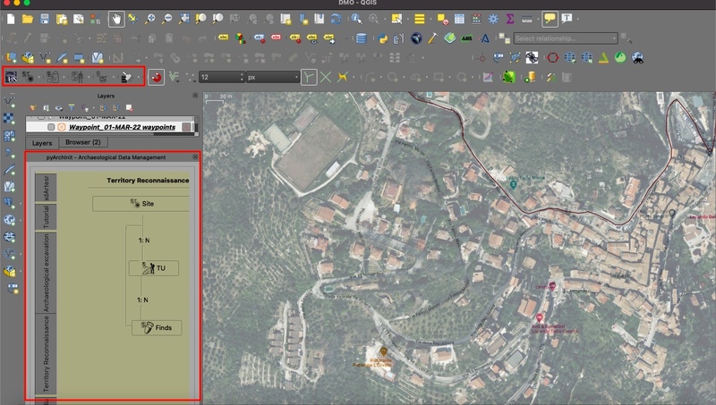
This article presents an attempt to integrate into a single workflow two important tools for the management of archaeological data: pyArchInit and BraDypUS. Although each system has its proper applications and capabilities, their combined use could have brought several advantages. However, it is worth noting that the work currently has some structural limitations that can be resolved only by the modification of the source code. This work summarises and reports on the current methodologies (as of 2021) for operating on both desktop and web platforms simultaneously using specific tools.
Mountain archaeology has a long research tradition and in recent years the number of studies on this topic has increased considerably, shedding new light on the dynamics of mountain’s communities. Versilia and Garfagnana districts (Lucca, North-Western Tuscany) largely fall between the Apuan Alps and the Apennine ridge. Although these territories have never been systematically investigated, the collection of all available archaeological legacy data indicates a settlement pattern of undoubted interest for the Roman times. This paper aims at exploring the settlement pattern of these mountain territories, integrating Point Pattern Analysis and Logistic Regression to achieve a predictive map of archaeological presences and to analyse their interrelations with the environment. Analyses prove the spatial dependence of finds with geomorphological and pedological variables, but also with the distance to major watercourses and solar irradiation. Based on the considered variables, the predictive map confirms that the foothill and gentler slopes facing E-SE areas have suitable characteristics for permanent settlement. Moving towards the more inland and higher altitude territories, the non-event areas increase proportionally, especially along the ridges, and the steeper, north-facing areas. Thus, the results make it possible to integrate the archaeological framework, clarifying human-environment dynamics, and directing new studies.
La città romana di Falerii Novi e quella pre-romana di Falerii Veteres vengono riviste in questo articolo attraverso la combinazione di dati da ricognizione lidar (light detection and ranging) e geofisica. La ricognizione lidar fornisce per la prima volta infomiazioni dettagliate sui bordi topograficamente complessi di questi siti e ha permesso di identificare un certo numero di nuove strutture. Osservando tali strutture nel contesto dei dati topografici e geofisici, sono state esplorate le aree urbane periferiche sia come zone per movimento sia come facciate. Tramite questi esempi vengono considerati i potenziali contributi forniti dal lidar alla comprensione generale dell'urbanismo pre-romano e romano.
3D digital imaging for the study of archaeology and the global dissemination of knowledge is of growing relevance and has proven to be extremely beneficial in particular on cases study characterized by a poor digital accessibility. With seven Unesco World Heritage sites, Sicily has an extraordinary heritage perfectly representing the cultural achievements of many Mediterranean civilizations, but yet the digital presence of such heritage is rather limited. The aim of this paper is to present the some methodological insights to tackle issues of 3D digitization of mosaic floor via digital photogrammetry on the basis of direct experience with the case study of the Roman Villa del Casale at Piazza Armerina (Enna, Sicily, Italy). The virtualization of over 2500 m2 of mosaic floord was carried out in the frame of an international collaborative project undertaken by University of South Florida’s Institute for Digital Exploration – IDEx (former CVAST), in partnership partnership with the Regional Department for Cultural Heritage and Sicilian Identity and specifically with the Regional Hub of Piazza Armerina, Aidone and Enna and the University of Catania’s Departments of Civil Engineering and Architecture (DICAR), Mathematics and Computer Sciences (DMI), and Humanistic Studies (DISUM).
The fortress of Ighram Aousser is located in Morocco, 10 km W of M’rirt and 120 km S of Meknés, on the so-called mines route. The lack of an organic and complete documentation and a concrete need to acquire new data about unexplored areas have required a multi-methodological research including the analysis of historical sources, archaeological surveys, topographic investigations, laser scanner modelling and geophysical prospections. All data were stored in a Geographic Information System, which allowed spatial analyses and the creation of thematic maps. The integrated geoarchaeological approach has led to a new archaeological map providing an updated view of the rich archaeological heritage in that territory. The article also offers a complete account of the valorization processes, the international promotion of the site and its long-lasting mining tradition.
In this paper we present the research strategy adopted during our archaeological survey in Lixus (Larache – Morocco). The aim of the project was to update the existing topographical documentation, based on previous researches, and to create the
The church of Santa Maria della Lizza is one of the most important examples of medieval architecture in the Salento Peninsula in south Italy. In order to understand the extension and layout of the crypts, integrated ground-penetrating radar (GPR) prospections and laser scanner surveys were undertaken in the church and in the surrounding areas. The analysis of the GPR measurements revealed many anomalies that could be ascribed to unknown structures (crypts), as well as other anomalies related to the old church. The GPR data were supported by the laser scanner data establishing the spatial relationship between the surface and the level below the church.
The generation of high quality 3D models can be still very time-consuming and expensive, and the outcome of digital reconstructions is frequently provided in formats that are not interoperable, and therefore cannot be easily accessed. This challenge is even more crucial for complex architectures and large heritage sites, which involve a large amount of data to be acquired, managed and enriched by metadata. In this framework, the ongoing EU funded project INCEPTION – Inclusive Cultural Heritage in Europe through 3D semantic modelling proposes a workflow aimed at the achievements of efficient 3D digitization methods, post-processing tools for an enriched semantic modelling, web-based solutions and applications to ensure a wide access to experts and non-experts. In order to face these challenges and to start solving the issue of the large amount of captured data and time-consuming processes in the production of 3D digital models, an Optimized Data Acquisition Protocol (DAP) has been set up. The purpose is to guide the processes of digitization of cultural heritage, respecting needs, requirements and specificities of cultural assets.
This paper focuses on the potential of an integrated approach using aerial LiDAR, aerial and terrestrial photogrammetry, terrestrial laser scanning, and archaeological survey to detect the presence and configuration of lost medieval settlements under canopy. This approach was applied to the site of Altanum (Calabria, Italy), on the hill of Sant’Eusebio, completely covered by vegetation. Altanum was a large fortified settlement characterised by a long occupation, especially during the Byzantine and Norman-Swabian periods. The activity began by carrying out a LiDAR survey of the whole hill. The acquired LiDAR data were processed and filtered in order to obtain a DFM (Digital Feature Model) useful for the identification of features of archaeological interest. Several enhancement techniques were performed on DFM to increase the visibility of archaeological features. The features thus identified were subsequently surveyed through the use of terrestrial and aerial photogrammetry integrated with laser scanning to document the visible buildings. The most significant result of the study was to create a single GIS platform with the integration of all data in order to delineate the whole settlement layout, as well as to produce 2D and 3D datasets useful for the for knowledge and protection of the identified remains.
The first part of the paper reviews the evidence for prehistoric, Samnite and Roman settlement and land-use in the Tappino valley region, and discusses in detail two sites at Cercemaggiore-Gildone: a Samnite farmstead abandoned probably in the second century BC, and a nearby cemetery of the fifth to fourth centuries BC, which may be associated with the first phase of occupation at the farmstead.The demography, dental pathology, nutritional state and work-induced lesions of the cemetery population (23 individuals) are analysed in the second part of the paper. High frequencies of oral lesions, especially in females, can be related to a poor, high-carbohydrate diet. Diseases of the joints and bone fractures indicate heavy physical activities, particularly in men.The evidence suggests that agriculture was the most important economic activity of this population. The sample is compared with others from central-southern Italy and a number of close correspondences emerge. It would appear that socio-economic changes, including differences in territorial organisation and subsistence activities, brought about a worsening of the general health of the human population.
In recent decades, photogrammetry has re-emerged as a viable solution for heritage documentation. Developments in various computer vision methods have helped photogrammetry to compete against the laser scanning technology, eventually becoming complementary solutions for the purpose of heritage recording. In the last few years, artificial intelligence (AI) has progressively entered various domains including 3D reconstruction. The Neural Radiance Fields (NeRF) method renders a 3D scene from a series of overlapping images, similar to photogrammetry. However, instead of relying on geometrical relations between the image and world spaces, it uses neural networks to recreate the so-called radiance fields. The result is a significantly faster method of recreating 3D scenes. While not designed to generate 3D models, simple computer graphics methods can be used to convert these recreated radiance fields into the familiar point cloud. In this paper, we implemented the Nerfacto architecture to recreate two instances of heritage objects and then compared them to traditional photogrammetric multi-view stereo (MVS). While the initial hypothesis posits that NeRF is not yet capable to reach the level of accuracy and density achieved by MVS as can be observed in the results, NeRF nevertheless shows a great potential due to its fractionally faster processing speed.
We look at relational processes of engagement, negotiation and articulation of digital heritage knowledge production. By looking at creative reuse and remix of digital cultural heritage we focus on how those processes manifest at the intersection of established cultural institutions and people outside of these institutions. Two experimental arrangements are described that seek to understand how Human-Computer Interaction and design interventions might contribute to new forms of heritage knowledge production and collective memory-making by mobilizing infrastructuring interventions to question knowledge production, politics and ownership. We conclude by proposing that HCI can contribute to infrastructuring for collective knowledge production by supporting arrangements that open access to digital cultural heritage, open heritage knowledge and its practices, and reimagine authorship and ownership of contributions to heritage.
How do the power dynamics of actors in digital knowledge production define the contours of global science and humanities? Where are scholars now in their efforts to improve a networked, global academic system based on the values of equal access to resources, inclusive participation, and the diversity of epistemologies? This article intervenes in these questions by discussing social dimensions of global knowledge infrastructure—connection, standardization, and access—to understand the specification and materialization of global digital humanities (DH). As digital practices expand across the world, the DH community struggles to ensure inclusive participation and equal opportunities in developing the field. This article shows that discrepancies in global DH lie at the root of existing infrastructure inequalities. Drawing on science and technology studies, it then argues that in order to overcome these imbalances, the academic community can seek the ‘infrastructuring’ of DH. Infrastructuring is an analytical concept that shifts attention from ‘structure’ to ‘process’ of co-creation in the vein of participatory design that foregrounds public engagement, shared interest, and long-term relationships with stakeholders to create networks from which equal opportunities and new forms of connections can emerge. This would involve building an inclusive network of unique nodes of local communities on top of the global knowledge infrastructure.
This report presents the findings of a study focused on infrastructure futures for digital cultural heritage, considering the processes and practices of preserving, managing, sharing and maintaining the cultural legacy of groups and societies in digital formats. We recognise digital cultural heritage as encompassing both digitised and born-digital artifacts and their tangible and intangible attributes, for preservation, management, research, and educational use. This necessitates dedicated infrastructures to support the complexities of digital preservation, access, analysis, and dissemination of heritage. The project explored the infrastructural needs and challenges associated with digital cultural heritage, aiming to understand current priorities, concerns, and hopes by imagining future possibilities through speculative design. A set of future scenarios were developed through a literature review and expert interviews, to provoke thought and discussion among stakeholders. These scenarios were explored through a survey and workshops, which allowed for the collection of diverse perspectives on digital cultural heritage infrastructures. The project identified several persistent issues in digital cultural heritage, including sustainability challenges due to short-term funding, difficulties in sharing knowledge across diverse disciplinary and operational contexts, and the impact of power dynamics on the inclusivity and accessibility of infrastructures. Additionally, the speculative scenarios highlighted that there is no one-size-fits- all solution to infrastructure design, emphasising the need for flexible, adaptable approaches that consider the varied needs of Gallery, Library, Archive, and Museum (GLAM) institutions and the communities they serve.
This article tells the history of the interaction between a scientific program and the use of digital technologies for handling and distributing archaeological information. We try to show, using an anthropological and epistemological approach, how archaeological work is modified by the introduction of digital technologies and the change in dynamics that this introduction causes to our scientific program. We also analyse the theoretical-ideological formation and the ethical problems arising from this interaction.
Most designers know that yellow text presented against a blue background reads clearly and easily, but how many can explain why, and what really are the best ways to help others and ourselves clearly see key patterns in a bunch of data? When we use software, access a website, or view business or scientific graphics, our understanding is greatly enhanced or impeded by the way the information is presented.This book explores the art and science of why we see objects the way we do. Based on the science of perception and vision, the author presents the key principles at work for a wide range of applications--resulting in visualization of improved clarity, utility, and persuasiveness. The book offers practical guidelines that can be applied by anyone: interaction designers, graphic designers of all kinds (including web designers), data miners, and financial analysts. Complete update of the recognized source in industry, research, and academic for applicable guidance on information visualizingIncludes the latest research and state of the art information on multimedia presentationMore than 160 explicit design guidelines based on vision scienceA new final chapter that explains the process of visual thinking and how visualizations help us to think about problemsPacked with over 400 informative full color illustrations, which are key to understanding of the subject
The age we live in is the age of the technological revolution: the social networks, virtual communities, 3D worlds, digital applications, immersive and collaborative games, are able to change our perception of the world as well as the way information is shared and transmitted. The shift of our society towards new technol-ogies has greatly facilitated the integration of these technologies (Virtual Reality, Augmented Reality, Photo-grammetry, etc.) in places such as archaeology, which in the past seemed like a very difficult idea. In recent years, archaeologists have begun to incorporate new technologies that can assist them in archaeological exca-vations. Such technologies include 3D Imaging Surveying methods (LiDAR, Mobile and Terrestrial 3D Scan-ners), Unmanned Aerial Systems (UAS), Photogrammetry as well as 3D Visualization Methods (Virtual and Augmented Reality) for the three-dimensional or two-dimensional display of sites where archaeological exca-vations are carried out. A big advantage of new technologies is the highly increasing capabilities and user friendliness over cost ratio, which encourages archaeologists to enter the emerging realm of Digital Archaeol-ogy. This paper summarises cutting-edge technologies that may assist archaeologists during the excavations process and reports related projects. At the same time, it overviews the literature for applications, tools and software implemented to operate directly to the excavation field (in situ) for the documentation, management, integration of the archaeological information and to facilitate the exchange, direct access and interoperability of the scientific data. We strongly believe that the present review would be very helpful to young researchers in the of field Digital Archaeology, since it assembles valuable knowledge from the scientific literature.
In the first section of this paper, some of the developments in the use of information science in archaeology are discussed, putting them in a more general framework of developments in archaeological theory. It shows the shift from “classical” statistical approaches, which concentrate on hypothesis testing, towards more heuristic, pattern searching methods of analysis. In the second section, some research is presented on the use of Bayesian statistics for solving archaeological problems. It illustrates, on the one hand, the case with which rather complicated quantitative analyses can be performed with the help of standard computing tools, and, on the other hand, the risks of carrying out such analyses without a clear, logically sound underpinning.
Classifying and categorizing the activities that comprise the digital humanities (DH) has been a longstanding area of interest for many practitioners in this field, fueled by ongoing attempts to define the field both within the academic and public sphere. Several European initiatives are currently shaping advanced research infrastructures that would benefit from an implementation of a suiting taxonomy. Therefore, new humanities and information science collaborations have been formed to provide a service that meets their needs. This working paper presents the transformation of the Taxonomy of Digital Research Activities in the Humanities (TaDiRAH) in order to make it machine-readable and become a formalized taxonomy. This includes the methodology and realization containing a complete revision of the original version, decisions in modelling, the implementation as well as organization of ongoing and future tasks. TaDiRAH addresses a wide range of humanities disciplines and integrates application areas from philologies as well as epigraphy, and musicology to name just a few. For this reason, the decision in favor of SKOS was made purely pragmatically in terms of technology, concept and domains. New language versions can now be easily integrated and low-threshold term extensions can be carried out via Wikidata. The new TaDiRAH not only represents a knowledge organization system ( KOS ) which has recently been released as version 2.0. According to the FAIR principles this new version improves the Findability, Accessibility, Interoperability, and Reuse of research data and digital assets in the digital humanities.
This unique text/reference reviews the key principles and techniques in conceptual modelling which are of relevance to specialists in the field of cultural heritage.Information modelling tasks are a vital aspect of work and study in such disciplines as archaeology, anthropology, history, and architecture. Yet the concepts and methods behind information modelling are rarely covered by the training in cultural heritage-related fields. With the increasing popularity of the digital humanities, and the rapidly growing need to manage large and complex datasets, the importance of information modelling in cultural heritage is greater than ever before. To address this need, this book serves in the place of a course on software engineering, assuming no previous knowledge of the field.Topics and features:Presents a general philosophical introduction to conceptual modellingIntroduces the basics of conceptual modelling, using the ConML language as an infrastructureReviews advanced modelling techniques relating to issues of vagueness, temporality and subjectivity, in addition to such topics as metainformation and feature redefinitionProposes an ontology for cultural heritage supported by the Cultural Heritage Abstract Reference Model (CHARM), to enable the easy construction of conceptual modelsDescribes various usage scenarios and applications of cultural heritage modelling, offering practical tips on how to use different techniques to solve real-world problemsThis interdisciplinary work is an essential primer for tutors and students (at both undergraduate and graduate level) in any area related to cultural heritage, including archaeology, anthropology, art, history, architecture, or literature. Cultural heritage managers, researchers, and professionals will also find this to be a valuable reference, as will anyone involved in database design, data management, or the conceptualization of cultural heritage in general.Dr. Cesar Gonzalez-Perez is a Staff Scientist at the Institute of Heritage Sciences (Incipit), within the Spanish National Research Council (CSIC), Santiago de Compostela, Spain.
The paper illustrates the computing section of a Strategic Project for the development of research methods applied to the study and safeguarding of the archaeological heritage of southern Italy. The project has been launched by the Italian National Research Council at the University of Lecce. The scientific aim of the system is the management of excavation data relating to problems emerging from the study of settlements. The system is characterised by: a) the integration of alphanumeric data, graphical data (site plans, archaeological maps) and images; b) the application of quantitative analysis. The system has been tested with the input of information from the excavation of sample sites at Otranto, Vaste and Oria (Italy) and Hierapolis (Turkey). The end result is a series of thematic and chronological maps of the settlements, which are of particular importance for centres such as Otranto which are under continuous pressure from building development. “Risk maps” have also been produced, which indicate areas where archaeological action is most urgent. The results form the base upon which we can construct a functional relationship between town councils, Superintendencies and the University so as to take the necessary steps that will avoid the sort of destruction of archaeological areas that has taken place over the last few years.
The application of computer science and advanced technologies to the topographical management of archaeological data have made it possible, in the last five years, to adjust an instrument of a strong tradition, such as the “Forma Italiae”, to the new requirements for the planning and protection of a territory. From the application of digital mapping to historical cities, the management of territorial archaeological data, satellite survey and multimedia distribution of information, the development outlook becomes gradually broader, respecting however, the methodological progress achieved during a century of tradition in historical topographical studies.