As part of the projects SIGRem and AtlasMed involving teams from the University of Reims, two steps were developed for the use of spatial data of various origins (archaeological, geographical, historical, etc.) with a Geographical Information System. Firstly, a global database called GISSAR was constructed and linked to a GIS begun in 2003 to allow the grouping and the working of information coming from different studies in the field of archaeology. Then, this collection of data files (photographs, plans, cards, texts, pictures, etc.) of all kinds should be considered when managing information, to put results online.
"'Metalli, creta, una piuma d'uccello...', questo verso dalla poesia Museo di Wisława Szymborska ci è parso particolarmente evocativo del multiforme interesse di Angela Ruta Serafini, Mariangela per molti, per tutto quanto ci arriva da quella 'curiosa creatura' che è 'il passato', dalle produzioni artigianali alle forme evanescenti del deperibile. Interesse per il passato, per la sua rigorosa indagine archeologica, per quanto dell'antica cultura materiale si è conservato ed è necessario custodire e valorizzare nella maniera più consona ed efficace, sono tra i principali aspetti a cui Mariangela si è dedicata e si dedica con sempre rinnovata passione. Della sua lunga e edinamica carriera archeologica, intessuta di legami profondi e sinceri con colleghe e colleghi, spesso divenuti cari amici, è testimonianza questo volume che raccoglie un ricco numero di scritti di archeologia e non solo, che molti studiosi hanno voluto dedicarle, esprimendole così la stima profonda, la forte amicizia e una grande riconoscenza. La miscellanea spazia dagli scavi archeologici alla cultura materiale, al linguaggio e all'interpretazione delle principali manifestazioni artistiche del Veneto antico, con attenzione anche ad aspetti significativi della museologia contemporanea, riflettendo i molteplici interessi di Mariangela che è stata per lunghi anni, da funzionaria della Soprintendenza Archeologica del Veneto, custode del patrimonio archeologico di numerose province, ma soprattutto delle città di Padova e di Este, che grazie ai suoi studi hanno assunto la consistenza che oggi si conosce. Attiva e sempre sul campo, è stata guida per molti giovani archeologi che con lei si sono formati grazie agli stimoli offerti dal sup radicato senso critico, dalla sua instancabile disponibilità a proficue discussioni, preludio di richerche e pubblicazioni condivise che hanno arricchito il panorama degli studi del Veneto antico. Di questa attitudine al lavoro di équipe sono qui prova i numerosi contributi di tanti giovani e non più giovani colleghi e collaboratori. Vivace comunicatrice, Mariangela ha saputo, da Direttrice del Museo Nazionale Atestino di Este, essere innovativa nella museologia, in particolare per la didattica museale di cui è stata senz'altro pioniera con spunti, idee e iniziative che ancora oggi sono un riferimento importante per tutti coloro che di musei, di comunicazione museale e di coinvolgimento dei diversi pubblici si occupano. Questa raccolta vuole quindi esprimere un grazie sincero ed essere un tangibile riconoscimento per Mariangela, instancabile acheologa, che ancora sa e saprà offrire molto con generosità agli studi e alla divulgazione archeologica"--
Quantitative studies of Attic figured pottery have interested many scholars as the existing vases represent only a modest percentage of the whole Athenian production, and their number is liable to change after any new excavation. Traditional systems of analysis confuse the pattern of ancient trade: near to the peaks of single cities, we have a total absence of data from areas that we would believe to be centres of a lively trade. The research conducted by the Institute of Archaeology of Catania University attempts to highlight the “commercial context” of the distribution of Attic pottery; data processing is based on a file divided in 13 areas and 47 sub-areas. The file follows the possible routes from East to West. The appendix describes the file of the Painter of Paris Gigantomachy, based on the vases assigned to him by J.D. Beazley. The painter’s production is analysed through three points of view: number and provenience of vases; provenience of shapes; provenience of subjects.
The article describes some bibliographic works carried out as part of the research line devoted to archaeological computing at the Istituto di Studi sul Mediterraneo Antico (ISMA), CNR. The work analyses, in particular, the rich bibliography on archaeological computing in the 1990s published on the website Virtual Museum of Archaeological Computing (http://archaeologicalcomputing.lincei.it/) and the digital bibliographies of Massimo Pallottino, Sabatino Moscati and Mauro Cristofani, some leading figures in our Institute’s history. Next, the text explores some examples of bibliographic resources available online (those relating to open texts and those relating to simple bibliographic references) and also describes some recently launched projects dedicated to virtual libraries and digital infrastructures in the field of human sciences.
Il volume di F.Castagnoli "Le ricerche sui resti della centuriazione" del 1958 resta un punto fermo nella storia degli studi sulle divisioni romane regolari per quanto riguarda l'aspetto topografico. L'avanzamento delle ricerche archeologiche, le nuove conoscenze scientifiche in relazione all'ambiente, le nuove tecniche di indagine, nonché la necessità di sottoporre a critica molte delle nuove proposte, rendono tuttavia indispensabile una revisione dell'argomento. I temi più significativi trattati sono: le novità nel campo della cartografia antica (il ritrovamento di nuovi documenti permette nuove valutazioni generali a proposito delle metodologie cartografiche, comprese le scelte di scala), il significato delle persistenze nei territori moderni di elementi delle divisioni antiche (ricerche geomorfologiche specifiche mostrano la grande varietà di soluzioni che storicamente si sono verificate), l'evoluzione della cartografia archeologica, i problemi di metrologia (che molto spesso è stata utilizzata senza controllo), l'analisi delle prime fasi di divisioni regolari in Italia e il loro rapporto con le divisioni in ambito greco coloniario. Si fornisce un quadro dei capillari interventi di Roma sul terreno nella sua espansione in Italia, da cui emergono da una parte rigide regole e schemi di organizzazione, dall'altra eccezionale capacità di adattamento alle situazioni ambientali diversificate, ciò che in molti casi ha permesso il mantenimento degli stessi allineamenti fino ai nostri giorni.
Le fonti sulla agrimensura romana sono varie. Gli scritti di agrimensori d’età domizianea e traianea (Frontino, Balbo, Siculo Flacco, Igino), i rari documenti archeologici ed epigrafici, ma soprattutto le tracce ancora visibili delle divisioni dei campi ci forniscono una conoscenza viva e concreta della agrimensura romana anche nei suoi aspetti storici e giuridici. L’autore, prendendo in esame la bibliografia topografica antica, spiega la tecnica agrimensoria nelle sue forme più specialistiche (dall’orientamento alla divisione per centuria e quella in strigae e scamna; dai soli e decumani ai limites), offrendo al lettore una delle testimonianze più affascinanti e concrete della sopravvivenza del passato.
The aim of this article is the description of: 1) the characteristics of the UNESCO's ISIS information system; 2) the general structure of the PART programme realized in Paris at the CNRS, and then developed in Tübingen (Archaeological lnstitute of the University) and Rome (Ecole Française), within an European research programme on la Castellina near Civitavecchia; 3) the use on-line of this database and the characteristics of its application by a group of scholars that are carrying out similar archaeological research.
First handbook on soundscape ecology for a graduate course in advanced landscape ecology Integration between soundscape and landscape principles Application of the soundscape ecology to nature conservation and human well-being
Prende l’avvio con questo volume il primo capitolo della lunga storia di Bologna, una storia che affonda le sue più lontane radici nel momento delle prime presenze dell’uomo nel territorio e giunge alle soglie del medioevo, dipanandosi attraverso il susseguirsi e il sovrapporsi di culture e di popolazioni diverse, ciascuna delle quali ha lasciato la sua significativa impronta. Etruschi, Celti, Romani organizzarono il territorio di Bologna sia dal punto di vista urbanistico che da quello economico e culturale; qui si affermarono artigianati locali, capacità produttive e manifestazioni artistiche di elevato valore, unitamente a un ventaglio molto ampio di contatti commerciali e culturali con altre popolazioni, vicine e lontane. Questo volume vuole essere un invito alla riscoperta di una città descritta nelle linee essenziali dagli scrittori antichi, ma che ancora ospita nel suo sottosuolo e nei suoi musei importanti testimonianze archeologiche del suo illustre passato.
This paper stems from the ongoing project ‘Atlante del Lazio: mappatura digitale deibeni archeologici’, which entails the digital mapping of the archaeological evidence from the Lazio region, dating between the 9th century BC and the 6th century AD, accessible via a digital platform that organizes the findings both in time and space. This objective aligns with the goals of Spoke 8, which focuses on developing methodological tools for cataloguing and reviewing archaeological data, specifically concerning the necropolises of Norchia and Poggio Montano, both located in the municipality of Vetralla (VT), within the Thiessen polygon referred to as ‘Blera’. From a methodological perspective, this paper presents two case studies, each relating to distinct chronological periods (the 8th-7th and 4th -1st centuries BC) and characterized by different funerary practices, which in turn necessitated tailored analytical approaches. The Poggio Montano case study, primarily based on planimetric data, allowed for relatively straightforward solutions. In contrast, the Norchia necropolis required a more complex methodology due to the architectural variety of the tombs, necessitating three-dimensional graphic reconstructions of elevations and structural elements. Given the specificity of the evidence, the study adopted a localized, in-depth analysis that integrates a qualitative dimension onto a shallow quantitative entry.
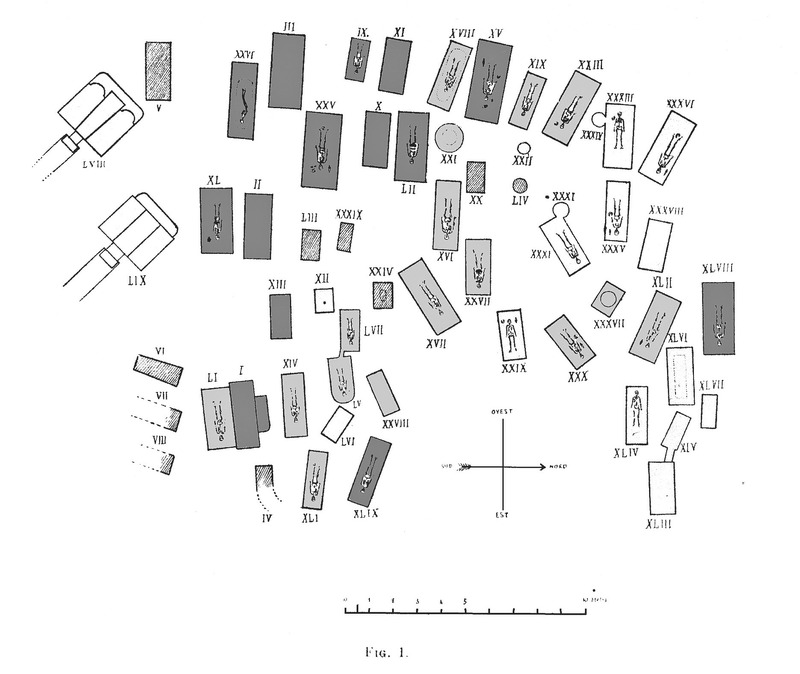
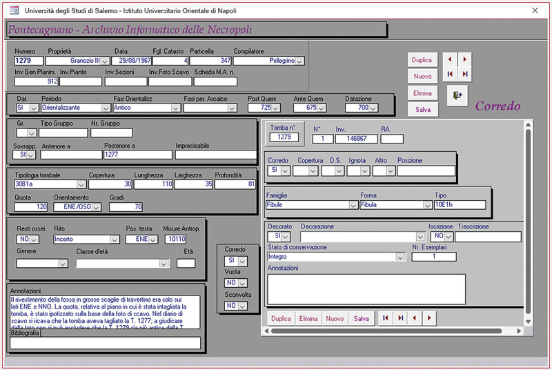
L’articolo raccoglie una serie di interventi sulla documentazione funeraria di Pontecagnano elaborati in occasione del PRIN: Etruschi in aree di confine e rapporti con i Greci. Il rituale funerario e l’ideologia della morte tra VI e V se. a.C. L’attenzione è incentrata sulla necropoli del Picentino, ad ovest dell’abitato, di cui sono editi da tempo sistematicamente i sepolcreti della Prima Età del Ferro e di alcuni settori impiantati ex-novo alla metà del IV sec. a.C.; la necropoli inoltre è stata oggetto di un progetto di informatizzazione mediante la redazione di un GIS. Lo studio delle sepolture databili tra il VI e la metà del IV sec. a.C. consente di colmare un vuoto della documentazione. Nella sezione curata da A.Serritella si approfondisce lo sviluppo topografico e le dinamiche di trasformazione tra il terzo quarto del V e i primi decenni del IV sec. a.C.
The paper is dedicated to the Geographic Information System developed for the filing and the analysis of Pontecagnano necropolises, where over 10400 tombs dated from the Etruscan to the Samnite phase (9 th-3rd century BC) have been excavated so far. The first version of the GIS was developed between 1999 and 2000 and initially tested on an area of the Western necropolis. It consists of an alphanumeric descriptive database, developed using Microsoft Access 2000, linked to a cartographic section implemented with the MapInfo software. The paper concludes with a preliminary presentation of the update of the information system, which is going to migrate to an open-source software.
Il sito di Çuka e Ajtoit, oggi in Albania Meridionale a pochi chilometri dal confine con la Grecia e in antichità centro di riferimento della regione di Cestrine, è noto in bibliografia per le imponenti fortificazioni di età ellenistica, un palinsesto di varie tecniche edilizie che vanno dal poligonale all’opera rettangolare isodoma. Quasi nulla è noto della localizzazione delle sue necropoli, che pure sono state “frequentate” anche in età recente da attività di scavo clandestino. Dalle indagini della missione archeologica italiana diretta da L.M. Ugolini che nel 1929 ha scavato qualche tomba alle più recenti ricerche sul campo della missione congiunta italo-albanese che vede coinvolta la Sapienza Università di Roma e l’Istituto Archeologico di Tirana, questo contributo cerca di offrire una panoramica esaustiva e aggiornata dello stato delle nostre conoscenze sulla cultura funeraria del centro antico.
The ever increasing presence of websites dedicated to antique numismatics and in particular to auctions of coins has raised the question of how this kind of material should be handled and the need to create highly specialised websites on a scientific level capable of monitoring, examining and organising the bulk of material circulating on the Internet. As far as Phoenician and Punic coinage is concerned, ISCIMA is in the process of setting up on-line a complete and thorough computerised database which is also part of its advanced studies program related to the early Italic civilisation of the Mediterranean basin. This streamlined database will group together all the websites dealing with Phoenician and Punic coins and provide a scientific bibliography of all the material concerning this subject.
En 1830, un fermier normand va, au cours d'un labour, mettre au jour fortuitement un des plus spectaculaire trésor d'argent jamais trouvé pour l'époque romaine. Ce ne sont pas moins de 128 objets de la plus grande valeur qui sortent de terre, statuettes de dieux, bols ou cruches décorés de scènes mythologiques, plats, à l'origine dédiés au dieu Mercure. Le sanctuaire portait le nom de Canetonum et dépendait de la cité des Lexoviens. L'enfouissement du trésor fut au départ attribué à des troubles ou à la menace d'invasion, mais on retient plutôt désormais l'hypothèse d'une cache simple. La plus grande partie du trésor est datable du IIe siècle mais neuf des pièces, parmi les plus belles, ont été dédiées par un certain Quintus Domitius Tutus et se rattachent au Ier siècle. Une partie des objets est de style gallo-romain, les autres sont l'œuvre d'un atelier italo-grec. Cet ensemble, connu sous le nom de « Trésor de Berthouville », va être acheté peu après sa découverte par la Bibliothèque Nationale de France pour le montant assez modeste de 15 000 francs et est désormais conservé au Cabinet des monnaies, médailles et antiques. A la suite d'une restauration méticuleuse de quatre années, conduite par les chercheurs de la Villa Getty, à Los Angeles, une exposition, « Roman luxury », permet pour la première fois de voir cette découverte dans son ensemble, accompagnée de gemmes, camées, bijoux et autres objets antiques de grand luxe ayant appartenu aux collections royales du cabinet des Médailles. Après son itinérance américaine (Los Angeles, Seatle, Atlanta, New York) l'exposition sera présentée en 2017 à Arles dans le cadre d'un partenariat signé entre la Bibliothèque Nationale de France (Cabinet des Médailles) et le Conseil départemental des Bouches du Rhône (musée départemental Arles antique). A la suite de cette unique présentation en Europe, le trésor et les autres objets seront mis en valeur de manière définitive dans les salles rénovées du Cabinet des Médailles à Paris.
La lussuosa residenza eretta tra il 118 e il 130 d.C. dall’imperatore Adriano ai piedi di Tivoli, che per le sue peculiarità aveva provocato stupore già tra i contemporanei, si connota ancora oggi come un’area monumentale caratterizzata da imponenti vestigia e da molteplici elementi di unicità. Questi, distinguendola dalle altre dimore imperiali, hanno contribuito alla sua iscrizione nella lista dei monumenti Patrimonio dell’Umanità dell’UNESCO come simbolo dell’Impero Romano. Questo volume, frutto del lavoro collettaneo di studiosi di diverse discipline, raccoglie saggi, schede tematiche, repertori iconografici, rilievi architettonici e una pianta aggiornata della Villa tiburtina. Tale documentazione sintetizza, aggiornandole, le conoscenze ad oggi attendibili sul complesso adrianeo, utili a nuove indagini, ma anche a chiunque intenda conoscere e apprezzare al meglio uno dei siti archeologici più noti al mondo
Deux dessinateurs, Jean-Baptiste Muret et Jean-Charles Geslin, ont pendant des années dessiné des antiques au sein des deux principales collections archéologiques françaises : le premier au Cabinet des médailles de la Bibliothèque nationale de France, de 1830 à 1866, et le second au musée du Louvre, de 1863 à 1870.Qu’il s’agisse de bijoux, de bronzes ou de terres cuites polychromes, venus d’Orient, de Grèce ou d’Italie, les deux dessinateurs ont su créer une documentation scientifique et sensible, alliant la précision du regard archéologique et le talent de l’artiste. Leurs recueils, qui rassemblent plusieurs centaines de dessins largement inédits, témoignent d’une sorte d’âge d’or de la documentation graphique au sein des musées, au moment même du développement de la photographie.Ils constituent aussi une source de première importance sur le goût de l’antique au XIXe siècle et sur l’histoire de l’archéologie et des collections françaises et européennes.
his research showcases the use of immersive digital technologies to enhance cultural heritage engagement, focusing on the archaeological site of Urbs Salvia, Italy. The project uses Virtual Reality (VR) to reconstruct and narrate the ancient ceramic production kilns of Pollentia-Urbs Salvia. The implemented activity aligns with the goals of the European Adrion TRANSFER project, ensuring a coherent and sustainable strategy for the archaeological park site. Through interdisciplinary methods, the team developed a Virtual Immersive Movie (VIM) combining detailed 3D modeling, texturing, and simulations with cinematic greenscreen footage. The virtual environment, designed for Meta Quest 3 headsets, includes both passive storytelling and active user interaction, enabling participants to explore reconstructed spaces and understand the ceramic production process. Advanced techniques in Blender and Unity ensured a realistic and engaging experience. User testing with 33 participants revealed high satisfaction rates regarding usability, visual appeal, and narrative clarity, with minimal instances of discomfort. The project sets a benchmark for integrating digital tools in cultural heritage, transforming traditional archaeological presentation into an accessible, immersive format. Future developments include expanding interactivity, incorporating gaming elements, and integrating AI-driven language models for multilingual real-time interaction, fostering inclusivity and sustainable heritage promotion.
With this work, the existence of a huge collection of brooches from the central Mediterranean landscape is for the first time presented and edited like a corpus. It reflects the relationship to the east Adriatic and Aegean, as well as the western Mediterranean regions, but also on past the Apennine peninsula to the north-reaching regions. The more than 8,000 bronze brooches, presented almost invariably at a scale of 1:3 on 739 panels, come mainly from southern Italy. About 1,000 were found in Sicily. They range from the 13th to 6th Century BC, but most belong to the latter centuries of this period. Italian text.
A collection of unpublished drawings by Jean-Baptiste Muret (1795-1866), kept at the Bibliothèque nationale de France (Paris), brings together in colour plates the drawings of almost 8,000 ancient objects, drawn according to the knowledge of his time. It is a precious and original testimony to the birth of archaeology as a science, and still has great heuristic potential today. The recent digital publication of this work allows us both to contribute to the history of the discipline and to give today’s researchers access to a wealth of documentation that is still useful for current studies. The presentation of the results of this research project will provide an opportunity to outline a proposed model for the digital publication of enriched historical sources, in accordance with the principles of open science and adapted to the specific needs of research in terms of scientific integrity.
The paper presents a series of methodological reflections on the following themes: survey, restitution, analysis and communication. The objective of the research was the critical reading of two of the most famous monuments in Ravenna and UNESCO heritage sites: the Mausoleum of Theodoric (ca. 520 AD) and the Mausoleum of Galla Placidia (before 450 AD). From advanced and integrated survey data, 2D graphs and 3D models were elaborated for hypothesis testing and for the multimedia communication of the scientific contents identified during the work. This second topic of the paper is part of the experiments conducted by the research group on new modes of multimedia communication, interactive and not, based on virtual models as an edutainment tool for enjoying monuments and masterpieces of cultural importance.
On Dionysus, dolphins and hybridity (N.B. I have lost 3 pages of my published paper, so I picked them out from my draft) Sur les rapports entre Dionysos et les dauphins, à partir de la catégorie de l'hybride, selon un parcours étymologique et lexical. Les dauphins sont des êtres hybrides ; ce sont aussi des fauves (θῆρες), équivalents marins des fauves continentaux et comme eux dotés d'ὕβρις. Les êtres hybrides foisonnent d'ailleurs autour de Dionysos, ainsi les Satyres ou les Centaures. Si familiers aux hommes, les dauphins appartiennent à un élément hostile ; de même, si proche et si joyeux, Dionysos est-il l'hôte assidu du marais infernal. Le dauphin incarne l'image d'une telle circulation : un bonheur qui franchit les limites de la δίκη pour viser à la saturation de l'ὕβρις, ainsi que Dionysos lui-même en montre la voie.
A set of related historical, geographical and cultural arguments shows that a connection exists between urban planning and territorial morphology for seven Greek colonies in Sicily, namely: Himera, Megara Hyblaea, Siracusa, Gela, Agrigento, Heraclea Minoa, Selinunte. It is discussed here how, in those cases, the neighbouring landscape justifies the geographical location, the site choice, and the displacements of functional and architectural elements in the site. The enlighted connection is concerned with both functional and aesthetical aspects of the landscape. The quantity and complexity of documents led to a different methodology of data analysis and presentation, i.e. the hypertext methodology, which, although not new, has been highly developed in the last few years thanks to the capillary diffusion of computers and especially the flourishing of programmes for the development of hypertext applications.
The aim of the present piece of work is to devise a tool for the computerized handling of information regarding the re-use of classical material in Medieval and Renaissance buildings. In view of the variety, loose structure and complex interrelations of the data in question, and in view of the kind of people likely to be interested in the product (historians, art-historians and archaeologists), hypermedia and hypertextual techniques were adopted. Thus, the software chosen was HyperCard, together with HyperKRS for improved searching. Particular attention was paid to the problems connected with the simultaneous handling of text and images, as well as to the definition of the user-interface and the search and retrieval operations. The pilot study made use of material from the archaeological Collection of the Opera Primaziale of Pisa.
Il volume nasce dalla necessità di indagare aspetti sono tutt’altro che chiariti, tra cui: il passaggio tra l’antichità e il medioevo nelle componenti che riguardano la struttura e la conduzione fondiaria; il rapporto tra insediamenti e paesaggio; il ruolo, la natura e i tempi dell’affermarsi (o riaffermarsi) di un’economia di scambio nei confronti della riorganizzazione degli spazi insediati.
The ISPC-CNR is conducting research activities aimed at identifying ancient quarries that supplied the public building sites in the Athenaion of Castro, where excavations revealed dry-stone city walls made of calcarenite blocks and built in three phases between the 4th and 2nd cent. BC. The paper is focused on the large coastal quarries of Porto Miggiano, located approximately 4.5 km NE of Castro, where the extraction was carried out in function of sea transportation of the blocks. The extraction sites were documented through laser scanning and photogrammetry by a drone. In the main quarry, which covers an area of approximately 0.4 hectares, thanks to the metrological analysis of the stepped faces, four extraction areas were identified corresponding to at least five cultivation phases. The oldest and most extensive one affects the central sector of the quarry, where large blocks compatible (for dimension and macroscopic aspect) with those of the third phase of the Castro city walls, dated to the beginning of the 2nd cent. BC, were extracted.
Depuis une dizaine d’années, l’augmentation massive des collections numériques de la Bibliothèque nationale de France (BNF) – Gallica, archives de l’Internet, métadonnées, etc. – ouvre de nouvelles pistes de recherche, faisant émerger des problématiques d’exploitation des données patrimoniales par les chercheurs. Pour répondre à leurs usages et besoins, la BNF met en place un nouveau service, le BnF DataLab, dont l’objectif est d’accompagner les équipes de recherche pour constituer et traiter des corpus numériques. Ce lieu, conçu pour le travail individuel et collaboratif, a ouvert ses portes en octobre 2021.
The dominant method of working has changed and is changing at an ever-increasing speed, also for the epigraphists: many computer applications are today available to process epigraphical data. This article provides a rapid survey of the major types of computer based projects in epigraphy. The procedure currently used at Bologna is explained here: its purpose is to produce an index of forms in Roman inscriptions. Data entry is still in progress, through the application of a set of utilities that has been written, to allow a two way transfer of data between WS and dBase III.
Il secondo volume della serie “30 anni di informatica archeologica”, pubblicato nella collana Futuro Anteriore, è dedicato alle banche dati per l’archeologia: sistemi di archiviazione ampiamente utilizzati in ambito archeologico fin dalla fine degli anni Sessanta del Novecento come efficace mezzo per gestire le consistenti quantità di dati con cui lo studioso si doveva confrontare nei diversi settori della ricerca sull’antico. La loro applicazione ha dunque percorso, caratterizzandola, tutta la storia dell’informatica archeologica. Il tema ben si adatta alle pagine di questa collana, che è nata con il proposito di proiettare nel futuro, attraverso una trasposizione temporale, le esperienze passate in funzione epistemica e con valore retrospettivo.
During the last years, the production of digital datasets in the Cultural Heritage domain, has seen an exponential increase and the structured repositories have become the most used infrastructure for knowledge management and consultation with different kinds of systems and platforms ensuring a complete interoperability and reach ability of data. Furthermore, the dataset products represent a great resource from which it is possible to extract and deduce new knowledge. In cultural heritage, thanks to the technology related to semantic web, we are able to manage and enrich our data using formalisms and data standards: digital libraries and digital archives, SPARQL-endpoint are some examples. This work, starting from the analysis of Europeana’s data model, discusses the integration and use of semantic data in third parts using the API system as a framework.
Le antichita romane opera di Giambatista Piranesi architetto veneziano, divisa in quattro tomi. Nel primo de' quali si contengono gli avanzi degli antichi edifizj di Roma disposti in tavola topografica secondo l'odierna loro esistenza ed illustrati co' frammenti dell'antica icnografia marmorea ... L'elevazione degli stessi avanzi: l'andamento degli antichi aquedotti nelle vicinanze e nel dentro di Roma ... Nel secondo, e nel terzo gli avanzi de' monumenti sepolcrali esistenti in Roma e nell'Agro romano colle loro rispettive piante, elevazioni, sezioni, vedute esterne ed interne ... Nel quarto i ponti antichi di Roma che inoggi sono in essere, colle vestigia dell'antica isola Tiberina, gli avanzi de' teatri, de' portici, e di altri monumenti, eziandio colle loro indicazioni e spiegazioni.
This article is based on the morphologic, archaeometric and quantitative study of amphoras found in room 16 and 17 of the horrea of S. Gaetano of Vada (Li), which form part of the port structures of Vada Volaterrana. The material belonging to the second of the two phases of the building (half of IV-VI/VII cent. AD) have been studied; this has allowed us to delineate commercial flows that, coming from the whole Mediterranean basin, have been related to the Vada Volaterrana harbour on the Northern Etrurian coast. The locally fabricated amphoras represent a large proportion of the finds (14,7%): these were used for wine, and were stored here before being exported. The majority of the imported amphoras came from North-Africa (65,8%), but they were also imported from the Eastern end of the Mediterranean (18,1%). Few, on the contrary, were imported from the Italian peninsula (11,4%), and these above all from the Iberic peninsula (4,7%). Also of note is the lack of imported amphoras from Gallia during the second phase of existence of the building.
The mapping project of the so-called area of the "Terme di Elagabalo" on the north-eastern side of the Palatine hill is the result of a long term cooperative effort between the University of Rome "La Sapienza" and the Institute of Technologies Applied to Cultural Heritage of the CNR (ITABC). This site has been under excavation since 2007, under the scientific supervision of the Department of Methodology and Techniques for Archaeological Research of the University of Rome "La Sapienza". As part of this project, one of the doctoral theses is addressing the subject of the compound of the Severian Age present on the site, with the purpose of identifying the history and function of the monument, by understanding and analysing the structure of the walls. Masonry mapping is an essential element for the study and analysis of archaeological monuments. In this case, a new technique was introduced which is the 3D scattergram photogrammetry, developed by the research department of ITABC. This new monitoring technique provided graphic documentation such as plans, views and sections especially where the traditional method had limitations and therefore it is extremely useful for the archaeological analysis of monuments and their contexts. Furthermore an objective 3D rendering was produced, thus providing a new form of scientific documentation for a better understanding of the current state of the monument and also for further research and monitoring. The purpose of proposing a doctoral thesis on this subject was to educate and train a new breed of professionals in the area of technology applied to cultural heritage.
The results of the stratigraphic and sedimentological analysis carried out at an exceptional archaeological site situated in the coastal plain of the Arno and Serchio Rivers (western Tuscany, Italy) are reported. The site, discovered near central Pisa, records a 1000-yr history of a riverine harbour built by the Etruscans and used by the Romans. This harbour was adjacent to the Arno River, located within an abandoned channel then still connected to the sea, thus allowing efficient stock transfer to and from Roman Pisa. The archaeological importance of this site is primarily due to the discovery of at least 16 well-preserved Roman ships and many other remains mostly deriving from their cargoes. The sedimentological relevance of this record is related to the recurrent, catastrophic, destruction of the harbour documented by the features of the sediment encasing the ships and by the ships’ distribution and age. Such repeated destruction was related to catastrophic flood flows generated by levee crevassing of the Arno River during high-magnitude floods that occurred between the second century BC and the fifth century AD. The Pisa harbour tells a story of river channel instability. The repeated flooding of the harbour indicates that the Roman Arno River attempted to abruptly change its course, exploiting a pre-existing river channel. The concomitance of climatic and eustatic causes is expounded upon to explain the sedimentary dynamic of a coastal floodplain during historical times.