The Vasa Rubra project started a couple of years ago with the aim of cataloguing and studying all the terra sigillata wares found in the ancient Roman town of Iulia Concordia, now called Concordia Sagittaria (VE). The first step in this project was the creation of a database able to respond to requirements, which were both scientific and aimed at protecting the archaeological objects. The process of creating the database, entirely dedicated to archaeologists, represented an opportunity to reflect on the use of databases in archaeology and for analysing the interaction between computers and users. Even if it continues to maintain its original meaning of tool, without becoming the final aim of the research, this database has demonstrated its usefulness for collecting data about the terra sigillata of Concordia, and has improved and facilitated the scientific study which followed.
Nel corso degli ultimi decenni, le coste del Mediterraneo sono state oggetto di numerosi studi multidisciplinari che hanno permesso di identificare con precisione le variazioni del livello del mare nel corso dei millenni. L’archeologia, grazie alle possibilità offerte dallo studio di manu- fatti sommersi in prossimità delle coste (indicatori archeologici), può appor- tare un notevole contributo a questo tipo di problematica. In questo poster viene presentata una sintesi dei più recenti lavori geo-archeologici svolti lungo le coste della Sardegna; viene inoltre proposto un confronto tra il dato archeologico e il più recente modello teorico di previsione.
This study shows how the analyses conducted using different kinds of disciplines (geo¬morphology, archaeology, history) can be an excellent way to focus on the origin of settlements and their attributes. The relational database is based on a ranking of archaeological, geological and historical data, followed by a single form of recording, such as excavation documentation (mapping and topography of settlements), or historical and hydrographical details. The use of a standard lexicon simplifies the implementation of data, according to a SQL language, while the data entry appears as a single window with direct access to all of the system. The GIS platform can be used for the analysis of geological (morphological and geological studies, coring), histori¬cal (cartographical sources) and archaeological data (survey, study of known materials). As a result, this approach led us to create different kinds of thematical maps, like morphological and hydrographical reconstructions of the past, by studying the underground and georeferencing historical charts. Subsequently, through a subdivision of layers, archaeological evidence was classified also by chronological and typological levels. This study allowed us to obtain a cross analysis between the concentration of archaeological material and environmental conditions at different levels of visibility. These results made it possible to evaluate the archaeological potential and the units, which were calculated by the relation between the density of evidence, the presence of alluvial deposits, the urbanization level and the water-bearing stratum, gave us an overview of the landscape evaluation.
Starting from the rock art located in Valle Camonica, the chapter illustrates the semiotic methodology for the identification and analysis of prehistoric cartographic representations. In this context, will be introduced both the proposed participatory research – which has the aim to investigate the value that the inhabitants attribute to the Camunian territory – and the cartographic systems realized at the CST-DiathesisLab, these are tools capable of understanding the sense of the territory and proposing a networked cultural and touristic enhancement.
Laura Lo Prete nella prima parte dell'intervento analizza l'intera struttura della Cappella Arcivescovile (494 - 519), determinandone l'esatta posizione all'interno dell'episcopio ravennate, su indicazioni fornite anche dai precedenti studi di Giuseppe Gerola del 1911. Dopo aver sostenuto le innegabili somiglianze che dovevano sussistere fra la cappella di S. Andrea e il monasterium di S. Apollinare, voluto dal clero ariano, del quale però non rimangono più tracce, cerca di rintracciare i modelli preesistenti nell'antichità romana. Ritiene che il sacello a forma di croce greca derivi da prototipi paleocristiani e cita come esempio l'oratorio di S. Prosdocimo a Padova. Questi modelli, a loro volta, sarebbero debitori dei romani martyria, di cui rimangono esempi notevoli nella città di Roma. Tutti questi edifici avrebbero precedenti nei cosiddetti Heroa ellenistici. La studiosa ritiene il sacello reliquiario ravennate stesso come un prototipo per le future cappelle di palazzo di signori ed imperatori, in particolare per la Cappella Palatina di Carlo Magno. Una tradizione simile, ma con varianti, nel passato, era stata in uso, si presume, già durante il regno di Costantino. Per quanto riguarda la decorazione musiva, Lo Prete è convinta che non solo ricorrano temi che si ricollegano alla figura del Cristo visto come imperatore, e guerriero vittorioso sui propri nemici, ma soprattutto nelle iscrizioni vi sia un riferimento al battesimo praticato nella cappella dai vescovi dell'epoca.
[ES] El presente trabajo, que constituye parte de la tesis doctoral de la primera autora, plantea una propuesta de medición de la calidad de los datos arqueológicos a través de la gestión de la vaguedad, concretamente de tres variables: incertidumbre, imprecisión e inexactitud. Si tenemos presente que el dato arqueológico es parcial desde su origen, valorar ese grado de parcialidad debería ser uno de los objetivos desde la obtención de los datos en las intervenciones arqueológicas y durante todo el proceso de investigación, con el objetivo de que nuestros resultados muestren las debilidades y fortalezas de nuestros datos y que los resultados de los análisis posteriores sean lo más honestos posibles con el lector. Aplicaremos la metodología propuesta a un caso de estudio centrado en el análisis de las dinámicas de poblamiento durante la Antigüedad Tardía, valorando la calidad de los datos como fase previa al análisis pero también como parte de los propios cálculos estadísticos.
Si presenta un quartiere di Vada Volaterrana, Porto di Volaterrae in età etrusca e romana, portato in luce in località S. Gaetano di Vada, Rosignano Marittimo (LI). Del quartiere, chiaramente connesso con le attività portuali, sono stati individuati numerosi edifici. Gli horrea, oggetto di questo volume, con le relative stratigrafie, strutture e soprattutto gli abbondanti materiali, permettono di ricostruire la lunga vita del quartiere che dal I secolo d.C. Alla seconda metà del VII secolo risulta attivamente connesso al network delle rotte mediterranee, costituendo un caso di studio statisticamente rilevante per l'analisi delle dinamiche commerciali antiche.
The utilisation of airborne laser scanning (Light Detection And Ranging, LiDAR) technology in archaeological research has developed signifcantly in recent years. The application of specifc algorithms to appropriate software can provide an accurate digital model of the Earth’s surface from LiDAR datasets, which helps to identify archaeological objects by the use and comparison of different visualisation techniques of the digital terrain model (DTM). Besides using LiDAR data, the application of various methods (e.g. documentation by terrestrial laser scanner and Total Station, aerial photographs, modern and historical maps, archaeological information, historical documents, on-site examination of earthwork features) helps to assure a more precise identifcation and interpretation process of the archaeological features. In addition, the Geographical Information System (GIS) offers a good solution for managing together all these various types of information in the same coordinate system. In this paper, the application of LiDAR analysis in GIS environment will be discussed and compared in two different research programmes. The HiMAT programme (History of Mining Activities in the Tyrol and adjacent areas) investigates the history of mining in the Eastern Alps and the APSAT project (Environment and Landscapes of Upland Sites of Trentino) focuses on the study of the upland anthropic system in Trentino area. In both research projects, LiDAR surveys were applied to investigate the archaeological areas such as mining regions and hilltop sites of upland areas. Some of the results from the sites surveyed by LiDAR and additional methods are presented in this paper including the discovery of new sites and the detection of new structures at known sites as well as the mapping of archaeological settings.
The nature of flints used in prehistory is essential information for increasing our knowledge of old settlements. The study of this raw material as well as the identification of its source, contribute to the evaluation of the mobility of prehistoric men and their behavior in relation to mineral resources, thus contributing to a better understanding of certain problems related to prehistoric economies. An innovative multi-field approach, based on a series of geological surveys of the siliceous formations of the French Massif Central, of Morocco and of northern Bulgaria, makes it possible today to better determine the limits of the areas exploited. The study is based on a complete examination of the evolution of flint on three scales (macroscopy, microscopy, ultramicroscopy) thus representing an improvement over petro-archaeology which traditionally uses the methods of petrography, mineralogy and micropaleontology. Moreover, the reconstitution of the initial shapes of material clarifies the technical procedures implemented for their exploitation. This methodological innovation, based on a rigorous sampling, makes it possible to present the results of an integrated analysis of the geological samples in their areas of natural diffusion. It proposes a refined paleogeographic vision of the removal made by men in these areas and of their anthropic and natural transformation at the archaeological site. The original diffusion of this scientific study, which is still in progress, is based on a platform of content management and groupware, called Map’N, which integrates access to cartographic webservices and online functions of geocoding of the iconographic and cartographic documents used or produced by these research projects.
In recent years, we have been witnessing the widespread use of low-cost, increasingly high-performance Unmanned Aerial Vehicles, or UAVs, equipped with a large number of sensors capable of extracting detailed information on several scales and in an immediate manner. This study was motivated by the need to perform a geological survey in an area with difficult physical access, and to compare the results with those from conventional surveys. Here we used a Multirotor UAV equipped with a high definition RGB camera and the digital photogrammetry technique to reconstruct a three-dimensional model of the Selmun promontory, located in the northern part of the island of Malta (central Mediterranean Sea). In this area, the evident cliff retreat is linked to landslide processes involving the outcropping geological succession, characterized by the over position of stiff limestones on ductile clays. Such an instability process consists of a lateral spreading associated with toppling and fall of different-size rock blocks. Starting from the 3D model obtained from the UAV-photogrammetry, a digital geological-structural survey was performed in which we identified the spatial geometry of the fractures that characterize the area of the Selmun promontory by measuring strike, dip and dip direction of the fractures with semi-automatic digital tools. Furthermore, we were able to measure the size and volume of singularized rock masses as well as cracks, and their sizes were mapped in a GIS environment that contains a large number of digital structural measures. It is the first application of this type for the Maltese islands and the results obtained with this innovative digital methodology were then compared with those of the traditional field survey of the same area acquired during a previous campaign. This study demonstrated how the innovation of digital geological surveying lies in the possibility of mapping areas and geological features not detectable with traditional methods, mainly due to the high risk associated with the stability of the cliff or, more generally, the inaccessibility of some sites, therefore allowing the user to operate in safety and to detect in detail the most remote rocky outcrops.
Herein we examine the use of a program-wide Twitter hashtag as a part of pre-service teacher education activities at one institution. After detailing the context around the hashtag's use, we use data mining, descriptive statistics, and social network analysis to examine more than 49,000 tweets sent over six years. We describe the traffic associated with the program-wide Twitter hashtag, the users who contributed, and the interactions that occurred among pre-service teachers (PSTs) and other users. The hashtag appeared to feature some opportunities and challenges for PSTs to observe and interact with peers, alumni, faculty and staff, and in-service educators.
Digital social science research has had an important impact on the types of methodological approaches to the internet and digital social phenomena, practices and communities. Whilst this paper does not seek to include empirical data, it aims to elaborate further on these debates in digital social research, that is, research on ‘life in digital society’ (Lindgren 2017: 230), using insights from my own research methods. This paper will firstly consider some methodological pitfalls that could sabotage our digital social archaeology research. It will then discuss the importance of understanding the framework and sources of our data. It will outline the two main methodological approaches I have used in my own empirical research to date – ‘thick’ social media data collection and analysis, and digital ethnography. It will discuss some of the many ethical considerations that must be assessed and implemented when undertaking this type of work. I will argue for a methodological pragmatism when undertaking social research in the fields of archaeology and heritage, although this pragmatism can be applied to any field of social study in the digital world.
This paper presents the preliminary results of a laser scanning survey carried out at the archaeological mound site of Arslantepe, located in eastern Turkey. The Italian Archaeological Expedition in Eastern Anatolia has largely brought to light its long history spanning from the 6th millennium BCE to the Byzantine period. The most outstanding evidence unearthed so far is a group of remarkably well preserved monumental buildings erected during the final centuries of the 4th millennium BCE, when the economic and political centralization reached its climax. Recently, the whole area became an open-air museum protecting the archaeological structures from climatic stress and enabling visitors to have a glimpse of the monumental complex as it was. The laser scanning survey was aimed at aiding the interpretation of the archaeological features through extremely accurate measurements as well as to provide the researchers with structural and condition monitoring of the surfaces overtime. Given the ever-changing plastic shape that mud-brick buildings take on over the time, this survey turned out to be an interesting challenge for testing laser scanner technology, since it is not easy to connect to any regular design.
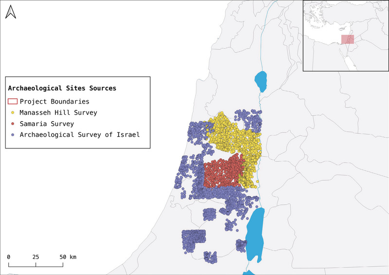
Distributed Version Control Systems are one of the common ways through which scientists collaborate and keep track of different versions of their work. Moreover, scientists, programmers, etc., have been using platforms such as GitHub to host and share their resources versioned through Git. While not as widely adopted as in other disciplines, Git has also been used in archaeological research. In fact, DVCS allow scholars to collaborate remotely and offer the transparency necessary to align with Open Science and reproducible research practices. However, Git is highly inefficient when versioning GIS data. Kart, described as «an open source DVCS for geospatial and tabular data built on git», is a software addressing the need for collaboration and finer incorporation of geospatial data, providing also an integration with QGIS. Kart and code-hosting websites offers unique resources for archaeologists, from collaboration to more efficient workflows. In this paper, an example of how the authors are using Kart, QGIS, and GitHub in the project ‘Governance Policies and Political Landscapes in the Southern Levant under the Neo-Assyrian Empire’ will be presented. With this case study, the authors hope to provide a solution to the current gap in the workflow of documentation and collaboration among archaeologists using GIS.
An old Chinese proverb says “Tell me and I’ll forget; show me and I may remember; involve me and I’ll understand.” More than any other medium, computer games have the intrinsic ability to involve their players in the world they depict; for they not only make us remember particular scenes we play, but also make us understand more of the world they involve us in. They are immersive, i.e. they make us forget the world around us, taking us away to a different place, a different life, or a different time.
In William Haughton’s 1598 play, Englishmen for My Money, the moneylender’s three daughters are courted by three unsuitable foreigners. The suitors are diverted
Today, archaeologists are spending more and more time examining the past with the aid of computers. How does this increased dependence on technology affect the theory and practice of archaeology?Using Computers in Archaeology is a comprehensive review of computer applications in archaeology from the archaeologist's perspective. The book deals with all aspects of the discipline, from survey and excavation, to museums and education. Discussion covers the theoretical aspects of computer applications, with particular reference to GIS and the analysis of data, but technical jargon is kept to a minimum.With numerous illustrations, case-studies and examples, Using Computers in Archaeology is a timely introduction to this increasingly important area of archaeology, catering both for the student and the experienced archaeologist.
Gran Dolina is a cavity that belongs to the second level of the Sierra de Atapuerca multi-level karst system and shows an Early and Middle Pleistocene sedimentary infilling 25 m thick, divided in eleven lithostratigraphic units. High densities of remains have been found in Gran Dolina, including hominid bones, fauna and lithic tools. The use of 3D models in stratigraphy and sedimentology is a new topic that allows new analysis and studies, increasing the knowledge of archaeological sites. In Gran Dolina site, the application of 3D laser scanning and photogrammetry techniques have allowed performing 3D models, including RGB textures. The models were georeferenced to the excavation local coordinate system. From these 3D models, we identified and mapped the continuity and geometry of the sedimentary levels, reconstructing the site's original stratigraphy. The 3D geometry of the levels was used to measure the clasts' textures and the post-depositional dips of the layers. The latter helped us to infer input strikes as well as their variations in each level, and to recognize ancient sedimentary entrances.
This work was developed to train graduate students as part of the Delphi4Delphi project dealing with the digital reconstruction of the archaeological site of Delphi. In this part of the project, various technologies were used for 3-d digital mapping cultural heritage structures for maintenance and restoration purposes. The use of various surveying technologies such as UAS, Total station, digital camera, Lidar scanner and GPS to map in 3d the remaining of the monument Tholos and the surrounding area in Delphi Greece and based on such mapping to restore the entire structure is covered in detail. The remains of such monuments are a few columns standing up joined with original elements on top. In this part of the project GPS was used to establish the reference system, total station was used to measure a number of control points for UAS, close range photogrammetry and Lidar scanner, UAS was used to map precisely the surrounding area together with the structure, close range photogrammetry and Lidar scanner were used to map the vertical surfaces of the structure. Processing of above data from all surveying technologies created enough point cloud to map precisely the remains of the structure and expand their architectural design to precisely restore the entire Tholos monument. Also all digital data are used by software for the construction of 3D terrain and 3D models which when inserted into Game Engines software aim at the creation of educational scenarios.
Over the last 50 years, countries across North Africa and the Middle East have seen a significant increase in dam construction which, notwithstanding their benefits, have endangered archaeological heritage. Archaeological surveys and salvage excavations have been carried out in threatened areas in the past, but the formation of reservoirs often resulted in the permanent loss of archaeological data. However, in 2018, a sharp fall in the water level of the Mosul Dam reservoir led to the emersion of the archaeological site of Kemune and allowed for its brief and targeted investigation. Reservoir water level change is not unique to the Mosul Dam, but it is a phenomenon affecting most of the artificial lakes of present-day Iraq. However, to know in advance which sites will be exposed due to a decrease in water level can be a challenging task, especially without any previous knowledge, field investigation, or high-resolution satellite image. Nonetheless, by using time-series medium-resolution satellite images, combined to obtain spectral indexes for different years, it is possible to monitor “patterns” of emerging archaeological sites from three major Iraqi reservoirs: Mosul, Haditha and Hamrin lake. The Normalised Difference Water Index (NDWI), generated from annual composites of Landsat and Sentinel-2 images, allow us to distinguish between water bodies and other land surfaces. When coupled with a pixel analysis of each image, the index can provide a mean for highlighting whether an archaeological site is submerged or not. Moreover, using a zonal histogram algorithm in QGIS over polygon shapefiles that represent a site surface, it is possible to assess the area of a site that has been exposed over time. The same analyses were carried out on monthly composites for the year 2018, to assess the impact of monthly variation of the water level on the archaeological sites. The results from both analyses have been visually evaluated using medium-resolution true colour images for specific years and locations and with 3 m resolution Planetscope images for 2018. Understanding emersion “patterns” of known archaeological sites provides a useful tool for targeted rescue excavation, while also expanding the knowledge of the post-flooding impact on cultural heritage in the regions under study.
Starting from statistical samplings or anthropological dynamics hypothesis, GIS predictive models are particularly helpful for archaeological site detection. About 11,000 B.P., during the transition from the last glacial period and Holocene, there was a gradual decrease of glacier in Europe and groups of hunter-gatherers began to populate extensive lands in central-northern Europe and in the Alpine region. Currently, the most documented and known prehistoric human settlement are those located in the eastern Italian Alps, where data collected for more than thirty years allowed to formulate realistic hypothesis about the dynamics of human population in the region. In the western Alps, data about this subject are limited: the project “Survey Alta Valsessera (Piedmont, Italy)” is aimed to fill this gap by combining field research with methodologies elaborated in the eastern Alps to find traces of prehistoric and late roman human settlements. A GIS predictive model was realized in accordance with the parameters exposed in the model elaborated for the eastern Alps and the field records collected. This GIS predictive modelling allowed to identify different areas with high archaeological potential. Two of the areas so identified have been investigated in 2016 and two new sites have been localized.
The generation of 3D models through Terrestrial Laser Scanning has proved to be valuable tools for the study, documentation and recreation of archaeological remains. In this context, it is described how to generate a physical model to provide not only to researchers, but also as teaching material for teachers for university students, facilitating their access and study. As a practical case, this article describes the acquisition, processing and management of archaeological data in the archaeological site of Cástulo, Jaén, in South Spain. We expound how to get the 3D-printed model of the Muslim tower, showing how it is possible to generate a scale and very reliable reproduction of the structure, being also an useful and tangible material in the teaching of cultural heritage.
The article presents the results of a wider research carried out by a multidisciplinary group (archaeologists and engineers) of the University and the CNR-ISPC of Catania in the South-Western Quarter of the Minoan Palace of Phaistos (Crete). The article focuses on two digital survey campaigns carried out respectively in 2014, laser scanning, and 2019, Structure from Motion. Starting from the point cloud by laser scanner, the most recent, low cost and user-friendly photogrammetric tools (GoPro camera and software Agisoft Metashape) have been used during the 2019 campaign in order to update and to improve the previous dataset, which was used as a grid for georeferencing and scaling the new virtual model. Special attention was addressed to the comparison of the two datasets and to the reuse of the first one for georeferencing and scaling the second one. Furthermore, the research has been focused on the opportunity to exploit the obtained virtual model both for scientific purposes and for the outreach. The lack of accessibility of the South-Western Quarter of Phaistos Palace to the visitors attributes a special interest to this output. The virtual environment thus realized constituted an ideal starting point for the development of an educational fruition project based on a Serious Game approach. The cooperation of archaeologists and engineers in the development of the Phaistos game ensures a gaming experience not only pleasant but also provided with a strong educational profile.
The contribution presents the results of a research that involves the use of data acquired by a multispectral camera transported by a UAV and their analysis and interpretation in the context of archaeological diagnostics. The experimentation expected the acquisition of multispectral images and the extraction of all the possible vegetation indexes on the basis of the spectral bands of the specific camera used (Sentera 6X). The tests, carried out in different contexts (Antium, Nersae), analyze the readability of the index data extracted from multispectral images in comparison with the marks visible in the panchromatic images, especially considering cases in which the marks are visible only in processed indices that interpolate the NIR band.
A dynamical model of a central place system is described which, derived from the concepts underlying dissipative structures, takes into account the self-organizing aspects of urban evolution, and shows the importance both of chance and of determinism in such systems. A theoretical evolution is discussed together with the modified dynamics of different possible decisions showing the long-term consequences of these. A recent application of this new theory to the evolution of the Bastogne region of Belgium is briefly described, and conclusions are drawn as to the real difficulties involved in decisionmaking on the part of national, regional, and municipal authorities.
The archaeological site of Tell Tayinat in the province of Hatay in southern Turkey was the principal regional center in the Amuq Plain and North Orontes Valley during the Early Bronze and Iron Ages. This paper focuses on the latest known period of occupation at Tayinat, which during the Iron Age was the Syro-Anatolian city of Kunulua. In 2004, following a 67-year hiatus, the University of Toronto’s Tayinat Archaeological Project (TAP) resumed excavations at the site. Here we present the preliminary results of TAP’s investigations of the Iron Age II and III settlement, including the topography of the 1st millennium settlement, super- and sub-structural remains associated with Building II (a temple first discovered in the 1930s), a second, newly discovered temple (Building XVI), part of a large Assyrian-style courtyard building, and the remains of additional monumental architecture on the Iron Age citadel. The terminal phases of these structures date to the Iron Age III period, or the late 8th and 7th century occupation of Kunulua following the Assyrian conquest in 738 b.c.e., and collectively point to the transformation of Kunulua’s royal citadel into a Neo-Assyrian provincial administrative center, a pattern witnessed at contemporary sites elsewhere in southeastern Anatolia and northern Syria.
This paper aims to understand the cultural diversity among the first modern human populations in the Iranian Zagros and the implications of this diversity for evolutionary and ecological models of human dispersal through Eurasia. We use quantitative data and technotypological attributes combined with physiogeographic information to assess if the Zagros Upper Paleolithic (UP) developed locally from the Middle Paleolithic (MP), as well as to contextualize the variation in lithics from four UP sites of Warwasi, Yafteh, Pasangar, and Ghār-e Boof. Our results demonstrate (1) that the Zagros UP industries are intrusive to the region, and (2) that there is significant cultural diversity in the early UP across different Zagros habitat areas, and that this diversity clusters in at least three groups. We interpret this variation as parallel developments after the initial occupation of the region shaped by the relative geotopographical isolation of different areas of the Zagros, which would have favored different ecological adaptations. The greater similarity of lithic traditions and modes of production observed in the later phases of the UP across all sites indicates a marked increase in inter-group contact throughout the West-Central Zagros mountain chain. Based on the chronological and geographical patterns of Zagros UP variability, we propose a model of an initial colonization phase leading to the emergence of distinct local traditions, followed by a long phase of limited contact among these first UP groups. This has important implications for the origins of biological and cultural diversity in the early phases of modern human colonization of Eurasia. We suggest that the mountainous arc that extends from Anatolia to the Southern Zagros preserves the archaeological record of different population trajectories. Among them, by 40 ka, some would have been transient, whereas others would have left no living descendants. However, some would have led to longer term local traditions, including groups who share ancestry with modern Europeans and modern East/Southeast Asians.
On social media platforms like Twitter, users regularly share their opinions and comments with software vendors and service providers. Popular software products might get thousands of user comments per day. Research has shown that such comments contain valuable information for stakeholders, such as feature ideas, problem reports, or support inquiries. However, it is hard to manually manage and grasp a large amount of user comments, which can be redundant and of a different quality. Consequently, researchers suggested automated approaches to extract valuable comments, e.g., through problem report classifiers. However, these approaches do not aggregate semantically similar comments into specific aspects to provide insights like how often users reported a certain problem. We introduce an approach for automatically discovering topics composed of semantically similar user comments based on deep bidirectional natural language processing algorithms. Stakeholders can use our approach without the need to configure critical parameters like the number of clusters. We present our approach and report on a rigorous multiple-step empirical evaluation to assess how cohesive and meaningful the resulting clusters are. Each evaluation step was peer-coded and resulted in inter-coder agreements of up to 98%, giving us high confidence in the approach. We also report a thematic analysis on the topics discovered from tweets in the telecommunication domain.
Digital technologies mediate engagement with the world by making activities visible. The automaticity and physicality of the ways in which they do this suggest that it could be productive to view them as responsive digital materials. This paper explores the structure and function of responsive materials in order to develop a conceptualization of responsive digital materials. It then begins to unpack the complexities of digital material mediation through both drawing on and extending existing postphenomenological theory.
The article explains the theoretical aspects of a cataloguing plan financed in the context of the so-called “Giacimenti Culturali” (Lana 41/86, Art. 15). This work concerns some areas of the city of Rome, in particular, monumental and topographical survey, territorial and architectonical cataloguing techniques, that are discussed here with the aid of computer science. The subsequent development of this plan will have as a fundamental issue the drawing of a prototypal magnetic Forma Urbis, suitable for, the safeguarding of the cultural heritage or for scientific purposes.
In this paper I will illustrate the function of an ArcGIS’s tool developed to carry out a series of landscape archeology’s raster analyzes in the contexts considered. Thanks to this tool, it is possible to quickly and immediately analyze both the primary economy of the settlements and the resulting socio-organizational forms, also verifying their functioning from the point of view of demographic sustainability. The work of the tool is simple and completely automated. In fact, once the center of the settlement to be analyzed is indicated, the system autonomously defines: 1) the size of the area exploited according to the bubble method; 2) the dimension of pastures and cultivated areas; 3) the relative food yields produced by these. Finally, through the yields of animal and vegetable origin, 4) hypoth- esizes the maximum number of people who could be supported by this exploita- tion of the territory
Excavations in Pisa carried out between 1985 and 1988 in Piazza del Duomo, close to the Leaning Tower (saggio D) provided much new data regarding the origins of the city. This book studies the ceramic finds and redefines the role of Pisa in the Hellenistic period as one of the major trade centres of northern coastal Etruria.The Etruscan character of the city of Pisa has been questioned for a long time. However, thanks to a thriving period of archaeological investigations undertaken in the mid-1980s, it was possible to definitively confirm the ancient Etruscan origin of the settlement. One of the main excavations was carried out between 1985 and 1988 a few steps away from the Leaning Tower (saggio D), where a complex and uninterrupted stratigraphy dating from the middle of the 6th century BC and the end of the 5th century AD was brought to light. The anthropic installations and wall structures unearthed share the same alignments and the same orientation, within an apparently orthogonal urban network designed at least from the end of the 5th century BC and knowingly respected until the end of the Roman imperial age.
The multivariate treatment of long pollen sequences coming from peat bogs constitutes an easy and effective method of factorial regression for the semi-quantitative reconstruction of the Paleoclimates. The comparison of the results obtained for the upper Pleistocene with the isotopic profiles of sea- and ice-cores, then with the previous methods, confirms a structuralization of the last climatic cycle in four periods: the interglacial Riss/Wurm including the optimum Eemian, the lower pleniglacial, the Wurmian interpleniglacial and the upper pleniglacial, before the Holocene. A numbering system of these oscillations, correlated with the Dansgaard-Oeschger events recognized in the ice-cores of Greenland, is proposed. A final statistical treatment shows a cyclic evolution of the forest vegetation during the Eemian, an evolution which better translates the variations of the Paleoclimates (temperature and humidity) than the arboreal pollen rate (AP).
A spatial analysis of pottery dumps is proposed on a layer of the Neolithic site of Chalain “station 3” (Jura, France). The proposed method analyzes, through diagonalization, a table of presence/absence of square meters per vase, then, through data analysis techniques, a co-occurrence matrix of the number of re-assemblages of pottery sherds within the square meters. The results show that dump areas are well correlated to the ancient buildings.
La chapelle Blanche de Sésostris Ier est l'un des chefs-d'oeuvres de l'architecture et de la sculpture de l'Égypte antique mais elle reste méconnue. Pourtant, ses bas-reliefs comptent parmi les plus remarquables de la région thébaine. Son architecture dite classique et surtout la finesse de ses gravures font de ce monument une œuvre exceptionnelle dans l'histoire de l'art. Datée du Moyen Empire (2033 à 1786 av. J.-C.), la chapelle Blanche est l'édifice en calcaire le mieux conservé du site de Karnak. Son histoire est assez incroyable puisqu'elle a été démontée dès la période pharaonique pour être remployée comme matériau de construction au Nouvel Empire par Amenhotep III dans les fondations du IIIe pylône. Pendant trente siècles à l'abri dans son écrin de pierre, préservée miraculeusement des pillages, des martelages et de la ruine, la chapelle Blanche a traversé les âges et a pu être reconstruite en 1938 dans le musée de plein air par Henri Chevrier. Cette publication électronique (ePub) doit beaucoup au talent d'Antoine Chéné. Le soin apporté à la prise de vue et aux traitements numériques a permis d'obtenir des images d'une qualité inégalée. Les architraves et les piliers peuvent ainsi être vus dans leur intégralité sans aucune déformation, ni ombre portée. Dans sa paléographie, Nathalie Beaux rassemble et étudie toutes les variantes des hiéroglyphes gravés avec tant de finesse sur la chapelle. Différents index réalisés par Alain Arnaudiès complètent ce travail. Cette version pour tablette donne un accès inédit à un monument de Karnak en ajoutant aux dessins et études de Lacau et Chevrier une couverture photographique complète, une paléographie et des index fouillés, en permettant pour la première fois de toucher du doigt, au sens propre comme au sens figuré, la beauté du monde égyptien.
The proposed principle for understanding the urban fabric is based on considering the town as a set of complex objects, taking a systemic approach. The town system used to study the urban fabric over large time spans is composed of three sub-systems relating to historical objects from the level of the excavation to that of the former urban space: function (social use), space (location, surface area and morphology) and time (dating, duration and chronology). The historical object is the analytical unit of the space studied. It is the Cartesian product of the three sets, Social use, Space and Time, from which it stems. On the basis of this process, the Historical Object (OH) is broken down into three types of simple object, functional (EF), spatial (ES) and temporal (ET). The thematic approach to the OH in an urban environment is based on social use, organized according to a hierarchical thesaurus. Space, the most formalized of the three sets, is structured on the model of a planar topological graph without isthmi. Time, always considered as continuous and linear, will be modelled through analogy with space using temporal topology defined in the field of artificial intelligence. The relationships between these three sets each characterize an interaction (social use-space, social use-time, time-space, or function-space-time). In addition to reconstructing the OH, they allow urban changes to be observed by analyzing the distributions and mapping of each of the entities singly or two-by-two. The originality of this procedure lies in its approach whereby it is possible to start not from the mapping of a phenomenon at a time t1 and comparing it to that at a time t2, but to look at it in the same way whether its input is social use, space or time. The heuristic value of this modelling lies in the shift from description (what, where, when) to understanding the phenomena of change (how, why).
Long-lived-in dwelling spaces provide a huge number of valuable data by which to figure out human activities and patterns of space use by prehistoric communities. However, cultural dynamics can intervene during deposit formation processes and transform depositional sets of rubbish involving artefacts and ecofacts. Notably, trampling resulting from human activities represents the most intrusive agent that affects spaces continuously used over a certain timespan. Therefore, comprehending the effect of trampling represents a key-step to assess the distribution of items in the archaeological record and to establish a solid base on which to build valid models of the use of space. This paper proposes a methodological approach to figure out the diverse effects of trampling. The methodology has been tailored on a specific case study, a long-lived-in dwelling area of the Bronze Age settlement of Coppa Nevigata (South-Eastern Italy), dated to the 12th cent. BC. Here, cycles of use and of the discarding of pottery produced a massive number of shards, whose primary deposition has been probably subjected to alteration by trampling. On this premise, the impasto pottery record has been considered as viable proxy to investigate the effects of this cultural agent on the archaeological record. The analysis proceeds by three main steps: a data entry process structured to optimize the recording of shards dimension, fragmentation rate analysis of shards and spatial analysis of well-preserved vessels. This integrated approach allowed an assessment of the reliability of distribution and conservation of the archaeological record in the studied spaces, providing crucial information to better understand use of space patterns through a second analytical step: spatial analysis of artefacts and ecofacts. An aim of this paper is to provide an analytical process replicable for further Late Prehistoric contexts.
Starting as early as the 6th century BCE in southern Gaul, viticulture extended after the Roman conquest as far as the south of England. This paper presents different types of multi-proxy spatial modeling incorporating climatic, environmental and geohistorical factors to analyze the causes of the expansion of vineyards outside the Mediterranean region in the 1st century CE. The effects of the Roman Climate Optimum on potential wine production were simulated through agrosystem modeling (Lund-Potsdam-Jena-managed-Land). We also produce a predictive model of areas potentially favorable to viticulture in the 1st c. CE, based on a series of geographical, archaeological and paleoclimatic criteria. The results highlight a strong impact of climate change on potential wine production as early as 1st c. BCE and favorable conditions for the development of viticulture as far as northern Gaul throughout the Roman period, especially on soils with southern exposures, along communication routes (main roads and rivers) and close to Roman urban centers. Necessary data to build the model are available at https://data.mendeley.com/datasets/j4gtjy9w87/3.
This volume is designed as a wide-ranging analysis of ceramic standardization and variation, and as a contribution to pottery studies in the Mediterranean and beyond. It originates in a conference session in the 16th annual Meeting of the European
"The 1992 publication of Pottery Function applied ethnoarchaeological data collected among the Kalinga and experiments to set forth the principles for the creation of pottery use-alteration traces (residue, carbonization, and abrasion). Analogous to lithic use-wear analysis, this study developed the method and theory making the connections between pottery use traces and function. At the 20th anniversary of the book, it is time to assess what has been done and learned. One of the concerns of those working in pottery analysis is that they are unsure how to "do" use-alteration analysis on their collection. Another common concern is understanding intended pottery function--the connections between technical choices and function. This book is designed to answer these questions using case studies from the author and many others who are applying use-alteration analysis to infer actual pottery function. The focus of Understanding Pottery Function is on how practicing archaeologists can infer function from their ceramic collection."--Publisher's website
Dimension reduction (DR) techniques such as t-SNE, UMAP, and TriMAP have demonstrated impressive visualization performance on many real world datasets. One tension that has always faced these methods is the trade-off between preservation of global structure and preservation of local structure: these methods can either handle one or the other, but not both. In this work, our main goal is to understand what aspects of DR methods are important for preserving both local and global structure: it is difficult to design a better method without a true understanding of the choices we make in our algorithms and their empirical impact on the lower-dimensional embeddings they produce. Towards the goal of local structure preservation, we provide several useful design principles for DR loss functions based on our new understanding of the mechanisms behind successful DR methods. Towards the goal of global structure preservation, our analysis illuminates that the choice of which components to preserve is important. We leverage these insights to design a new algorithm for DR, called Pairwise Controlled Manifold Approximation Projection (PaCMAP), which preserves both local and global structure. Our work provides several unexpected insights into what design choices both to make and avoid when constructing DR algorithms.
Nowadays, archaeology and modern 3D modelling and representation technologies form an unbreakable bond, considered essential and indispensable by many experts and scholars. Although with different goals and purposes, new hardware and software available and specially designed web platforms allow the archaeologist adequately trained to create, visualize, analyze, and share 3D data derived from computer graphics or from image- and range-based acquisition procedures. Currently, a very important topic is the relationship between user and 3D model: from the simple passive fruition, we are moving increasingly towards a real interaction within immersive virtual environments. In this sense, the contribution of the archaeologist is critical to determine what to display and what to interact with, according to the end user and his skills and knowledge. In fact, the following case studies related to sites, monuments and artefacts of the Etruscan town of Volterra represent the evolution of this interaction/relationship, helping to make the fruition of archaeological evidence, that at present is still difficult to access and understanding, easier and more interesting.
Despite centuries of research, much about the barbarian migrations that took place between the fourth and sixth centuries in Europe remains hotly debated. To better understand this key era that marks the dawn of modern European societies, we obtained ancient genomic DNA from 63 samples from two cemeteries (from Hungary and Northern Italy) that have been previously associated with the Longobards, a barbarian people that ruled large parts of Italy for over 200 years after invading from Pannonia in 568 CE. Our dense cemetery-based sampling revealed that each cemetery was primarily organized around one large pedigree, suggesting that biological relationships played an important role in these early medieval societies. Moreover, we identified genetic structure in each cemetery involving at least two groups with different ancestry that were very distinct in terms of their funerary customs. Finally, our data are consistent with the proposed long-distance migration from Pannonia to Northern Italy.
Classification has been an important archaeological activity for at least a century. It should not be seen as an end in its own right, but as a tool that enables archaeologist to compare and communicate. It can also be seen as mathematical activity, the study of relationships between entities in a multi-dimensional space. Comparison of these approaches leads to a set of criteria for a “good” classification. A wide and growing range of techniques is available, but more fundamental issues such as the choice of variables and the level of analysis must also be considered. The history of classification in archaeology shows a period of optimism followed by one of disappointment; the recent development of techniques more suited to archaeological needs may enable a middle view to be taken. Finally, the role of classification is assessed in the light of current trends in archaeological theory.
Previous archaeological mapping work on the successive medieval capitals of the Khmer Empire located at Angkor, in northwest Cambodia (∼9th to 15th centuries in the Common Era, C.E.), has identified it as the largest settlement complex of the preindustrial world, and yet crucial areas have remained unmapped, in particular the ceremonial centers and their surroundings, where dense forest obscures the traces of the civilization that typically remain in evidence in surface topography. Here we describe the use of airborne laser scanning (lidar) technology to create high-precision digital elevation models of the ground surface beneath the vegetation cover. We identify an entire, previously undocumented, formally planned urban landscape into which the major temples such as Angkor Wat were integrated. Beyond these newly identified urban landscapes, the lidar data reveal anthropogenic changes to the landscape on a vast scale and lend further weight to an emerging consensus that infrastructural complexity, unsustainable modes of subsistence, and climate variation were crucial factors in the decline of the classical Khmer civilization.
The Wroxeter Hinterland Project is a three-year regional research project employing GIS technology in the planning, management, research and publication of a study of the Iron Age and Roman landscape around the Roman city of Viroconium (Wroxeter) in Shropshire. The use of GIS technology in projects such as this has again highlighted the problems associated with scientific interpretation of the known archaeological record, built up mainly over the past century. In particular, the capability of GIS to recognise, extract, and extrapolate patterns in multivariate map data has meant that archaeologists must now resist the temptation to interpret such patterns as anything more than relatively recently introduce biases of site preservation and visibility. This paper explores ways in which GIS can be used to discover, and correct, such biases.