Nota introduttiva alle normative per la catalogazione dei beni archeologici, Roma, Istituto Centrale per il Catalogo e la Documentazione – Servizio Beni Archeologici
Music was one of the earliest kinds of art to explore the creative use of electronic and information technologies: new musical forms have assumed an increasingly artistic importance since the second half of the last century. Technology, at the same time, also is the cause of their rapid deterioration and risk of disappearance. The conservation of this heritage presents very different problems from those posed by traditional artworks. To this purpose this paper first presents some results for the conservation of audio documents: a well-tuned re-mediation methodology, an artificial intelligence based approach to detect audio tape discontinuities and access tools for renovating the listening experience of old analog media. To safeguard this heritage, it is not enough to digitize the content of recordings and documents, but all the related information, collected on the author’s personal archive, must also be accessible. The second part of this paper presents in detail, as a case study, the design and development of an information management system allowing the long-time preservation and the access to different documents, among them: audio, letters, musical scores, and manuscripts of the personal archive of an important electronic music composer.
Jacopo Bonetto, Presentazione. Marco Edoardo Minoja, Presentazione. Anna Gutiérrez Garcia M., Premessa. Introduzione. 1. Le cave di pietra della Sardegna: storia degli studi. 2. Archeologia dell'edilizia a Nora. Storia degli studi sulle cave e sull'uso della pietra. 3. Nora e il suo territorio: inquadramento geologico. 4. Le cave di Nora e del suo territorio. 5. Le cave del territorio di Nora: considerazioni di sintesi 6. lo sfruttamento delle cave e l'uso della pietra a Nora dall'VIII secolo a.C. all'età tardoantica. 7. Atlante dei materiali lapidei del territorio di Nora. Bibliografia generale.
This paper stems from research carried out in Nora over the past decade and presents new evidence that sheds light on the life of the settlement during the 5th century BC. Archaeological evidence shows that the Phoenician emporium that thrived
Il contributo sintetizza in chiave storica i dati editi relativi alla lunga fase di transizione vissuta dalla città e dal territorio di Nora fra la tarda antichità e l’alto Medioevo. La documentazione esaminata consiste in gran parte nei risultati delle ricerche condotte nell’ultimo ventennio dalle Università di Genova, Milano, Padova, Pisa, Venezia e Viterbo e dalla Soprintendenza Archeologica di Cagliari e Oristano. Grande rilevanza nella formazione dell’abitato altomedievale rivestono la progressiva destrutturazione dell’assetto urbano di età romana e lo sviluppo di nuove forme di edilizia abitativa. Nell’area necropolare suburbana si afferma il polo cultuale di Sant’Efisio, mentre nel territorio vari indizi confermano una sostanziale continuità di vita sino alla fine del VII secolo.
The contribution addresses the issue of the structural and spatial articulation of the Phoenician settlement of Nora, which has clearly emerged in recent years thanks to targeted surveys conducted by the University of Padua at the site of the Capo di Pula. The investigations carried out in the central area of the Roman city, between the Forum and the Roman Temple, have brought to light important clues of a nuragic settlement close to which the Phoenician emporium was established. Other research in recent years has also identified archaic presences in the extreme southern spaces of the promontory, within the Punic and Roman sanctuary of Aesculapius, and in the northern area of the isthmus. Here, between 2014 and 2019, a new Phoenician necropolis was progressively discovered, used at least from the first half of the 7th century. B.C. These recent researches confirm that the inhabited area must have been composed of light and renewed architectures over time (huts and tents in perishable material), but have highlighted a highly evolved spatial conception of the archaic settlement, which already consisted of distinct sectors of inhabited, religious and funerary spaces such as the later Punic and Roman urban realities.
In this article, we propose a general framework for the unsupervised fuzzy rule-based dimensionality reduction primarily for data visualization. This framework has the following important characteristics relevant to the dimensionality reduction for visualization: preserves neighborhood relationships; effectively handles data on nonlinear manifolds; capable of projecting out-of-sample test points; can reject test points, when it is appropriate; and interpretable to a reasonable extent. We use the first-order Takagi–Sugeno model. Typically, fuzzy rules are either provided by experts or extracted using an input–output training set. Here, neither the output data nor experts are available. This makes the problem challenging. We estimate the rule parameters minimizing a suitable objective function that preserves the interpoint geodesic distances (distances over the manifold) as Euclidean distances on the projected space. In this context, we propose a new variant of the geodesic c-means clustering algorithm. The proposed method is tested on several synthetic and real-world datasets and compared with the results of six state-of-the-art data visualization methods. The proposed method is the only method that performs equally well on all the datasets tried. Our method is found to be robust to the initial conditions. The predictability of the method is validated by suitable experiments. We also assess the ability of our method to reject test points when it should. The scalability issue of the scheme is also discussed. Due to the general nature of the framework, we can use different objective functions to obtain projections satisfying different goals. To the best of our knowledge, this is the first attempt to manifold learning using unsupervised fuzzy rule-based modeling.
Many areas of science depend on exploratory data analysis and visualization. The need to analyze large amounts of multivariate data raises the fundamental problem of dimensionality reduction: how to discover compact representations of high-dimensional data. Here, we introduce locally linear embedding (LLE), an unsupervised learning algorithm that computes low-dimensional, neighborhood-preserving embeddings of high-dimensional inputs. Unlike clustering methods for local dimensionality reduction, LLE maps its inputs into a single global coordinate system of lower dimensionality, and its optimizations do not involve local minima. By exploiting the local symmetries of linear reconstructions, LLE is able to learn the global structure of nonlinear manifolds, such as those generated by images of faces or documents of text.
Most standard spatial analyses assume stationarity, i.e. that the generative process producing the observed pattern is spatially homogenous, and hence its
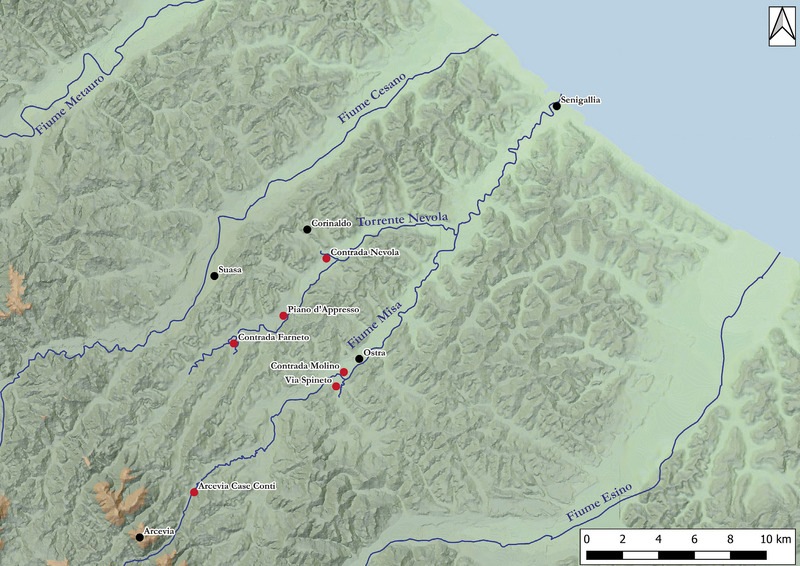
The paper focuses on several sites in the northern Marche region identified by the presence of circular traces detected by remote sensing and tentatively interpreted as funerary monuments of the pre-Roman period. After a brief overview of this characteristic type of archaeological evidence, the results of recent field activities aimed at studying these sites with an integrated approach, including remote and proximal sensing, geophysics and field survey, are presented. The final aim is the theorisation of operational intervention protocols, functional for both territorial research and the safeguarding of the buried archaeological heritage, as part of a prevention strategy based on the non-invasive characterisation of contexts.
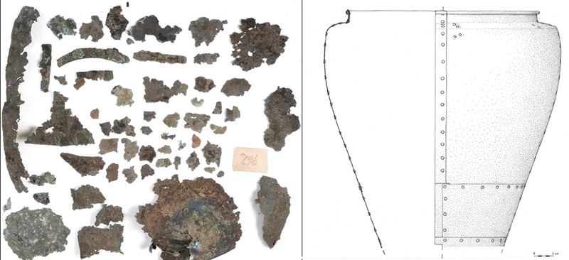
This study presents the preliminary results of a non-invasive analysis of bronze fragments from the site of Buttrio (Udine). The analysed sample belongs to a bronze situla dating to the second half of the 7 th century BC, currently preserved in the Archaeological Museum of Udine. These fragments are characterised by the presence of mineralised traces of textiles, which are relatively rare finds in this period but provide important information about the perishable materials, which represented one the most important and time-consuming economic activities of the past. The aim is to identify the fibres used in the production of the textiles, understand the manufacturing processes employed, and explore the nature of the archaeological context. The textile traces were analysed using standard analytical procedures to determine the main structural parameters, including weave type, thread
This paper aims to share the preliminary results from the non-invasive investigations initiated in 2023 at the archaeological site of Atella in Sant’Arpino-Caserta led by the Archaeological Digital Mapping Lab at the University of Naples Federico II. Located about halfway along the road from Capua to Neapolis, Atella and its surrounding territory lie in the central sector of the Campanian plain—a wide alluvial plain formed by the rivers Volturno and Clanio, north of Mount Vesuvius and the volcanic caldera of the Campi Flegrei. Historically renowned for the ‘fabulae Atellanae,’ the site’s overall archaeological topography remains largely uncharted. The new archaeological project began with a renewed evaluation of remotely sensed data and included an intensive field survey and geophysical prospection using Ground Penetrating Radar. The 2023 campaign was conducted from June to September in Fondo Guarino-Sant’Arpino, which is believed to encompass Atella’s central monumental area.
In the statistical analysis of spatial point patterns, stationarity is often assumed to mean that the spatial point process has constant intensity and uniform correlation depending only on the lag vector between pairs of points. In other words, it is assumed that the correlation between the elements of a spatial distribution is a function of the Euclidean distance between them. This framework has been vastly used in Spatial Analysis to describe settlement processes, taking into account a homogenous and undifferentiated surface that is easy to generalise. These assumptions fail when we consider the historical and economical dynamics that took place in space.
Non-destructive pXRF has the potential to expand sample populations of archaeological provenancing studies by facilitating access to museum collections of artefacts. In this study, we use museum-curated obsidian for the sites of Tell Brak, Mersin-Yümüktepe and Tell Arpachiyah and geological obsidian samples from central Turkey to demonstrate that non-destructive pXRF is comparable to other techniques in differentiating between Near Eastern obsidian sources. Secondly, we use multivariate analysis to evaluate whether non-destructive pXRF is sufficiently accurate and precise to enable comparison with legacy datasets from previous analysis using PIXE and ICP-MS. Multivariate analyses show that instrumental offsets between the results from pXRF and other analytic techniques are less than source-to-source variation typical for most Anatolian obsidian outcrops and pXRF-identified geochemical groups are directly comparable to legacy datasets. Non-destructive pXRF analysis indicates that during the Chalcolithic, East Göllü dağ and Nenezi dağ continued to be the major sources of obsidian to communities in central Anatolia and the Bingöl range and mountains surrounding Lake Van supplied sites east of the Levant. Variations in the analysed assemblages suggest a number of obsidian exchange networks existed during this period.
Nike is a computer system to support the archaeologist’s work. It can be used from the early phases of an archaeological excavation: from information gathering, to the actual excavation, up to the elaboration of its results. Nike organises in a single data base both graphical and textual data, in order to facilitate the collection, preservation, maintenance, and retrieval of information. Nike is a highly interactive system, and the navigation in the database depends on the result of the previous choice, according to the logical links present in the data itself, and guided by the specific needs of the researcher.
This book brings together the philosophies of technology and nihilism to investigate how we use technologies, from Netflix and Fitbit to Twitter and Google. It diagnoses how technologies are nihilistic and how our nihilism has become technological.
The author describes new additional qualities of the program ARBOR which allow a less redundant object description and facilitate the setting up and the use of pictorial databases.
Begun in the Summer of 2016, the Villa Romana di Poggio Gramignano Archaeological Project – a partnership between the Soprintendenza Archeologia dell’Umbria, the University of Arizona, and the town council of Lugnano in Teverina – continues a work initially begun in the 1980s. The present report illustrates the preliminary results obtained after the years of excavation 2016-2019. The aim is to contribute to the debate concerning the causes of the end of Roman villas in the western part of Empire.
Lo studio ricostruttivo di un monumento antico risente fortemente di lacune informative, errata trascrizione delle fonti, errata traduzione o peggio ancora, di interpretazioni soggettive che possono compromettere drasticamente il risultato finale, portando a ricostruzioni anche notevolmente diverse tra di loro. Questo lavoro vuole presentare i risultati di uno studio ricostruttivo condotto filologicamente su alcuni monumenti di Siracusa in età greca, cercando di evidenziare il contributo specifico dell'archeologia virtuale nei processi interpretativi, al fine di proporre una presentazione efficace rivolta ad un target specifico di turisti. Seguendo questo approccio sono stati ricostruiti il Tempio di Apollo, il complesso monumentale di piazza Duomo ed il Teatro greco, cercando di fornire output di visualizzazione che fossero adeguati ad una consultazione da smartphone e coerenti alle finalità generali del progetto "PON Energia Smart City". Questo progetto prevede un approccio "smant" alla visita di Siracusa, privilegiando principalmente logiche di fruizione efficiente on-site grazie all'adozione di tecnologie basate sulla Realtà Aumentata, la visione dei monumenti da punti inusuali e la visita virtuale multimodale dei punti di interesse. Emerge da questo studio la nuova fisionomia di quei monumenti che, per motivi diversi, sono stati rappresentati negli anni in forme e modi del tutto differnti, tali da rendere a volte irriconoscibili le diverse ricostruzioni dello stesso oggetto. Grazie alle tecnologie di restituzione 3D basate sull'immagine è stato possibile integrare le parti mancanti di alcuni elementi architettonici e scultorei che, ricollocati virtualmente nella posizione originaria, permettono una lettura dinamica che combina l'aspetto reale con quello virtuale.
The study of the Attic-figured pottery is closely connected with the ‘Beazley method’, which consists in the possibility of recognizing a painting ‘hand’ exclusively based on the style of the work; the Beazley method, despite having suffered some criticism, is still considered substantially valid. The need to have images which can be analyzed from a stylistic point of view, has suggested to combine the use of some open-source programs of 3D photogrammetry (such as VisualSFM and Meshlab) and 3D modeling (such as Blender), in order to shift the figured frieze from the pot to paper, avoiding the limitations associated with traditional direct drawing.
The Agrigento: insula III Project began in 2016 thanks to an agreement between the Parco Archeologico e Paesaggistico Valle dei Templi di Agrigento and DiSCi - Bologna University; it aims to document an entire sector of the Hellenistic-Roman quarter, in a three-year period. The main goal is to start a systematic study of private housing from the Archaic period to Late Antiquity and, at the same time, provide a critical understanding of the town planning scheme in this part of the town, which still lacks a modern archaeological and topographical documentation. The interpretation of the previous documentation is the starting point, along with new mapping with laser scanning and a systematic campaign of geophysical investigations to obtain a BIM. As the Bologna University tradition teaches, modern technologies can answer precise historical and archaeological questions: what are the primary phases of the town map? Which one is the starting module of each lot and what are the changes in different ages? Is it possible to reconstruct the original architecture of Hellenistic houses? What is the relationship between this quarter and the rest of the town? The integration of traditional investigational techniques with more recent ones is the methodological assumption of the project, in order to solve the analysis of the complex stratigraphy of the setting, which was inhabited for at least a millennium, from the Archaic to the Middle Ages.
Lidar (Light Detection and Ranging), which has recently come into use for airborne environmental monitoring, is now beginning to find success in archaeological survey. Liaison between the Environment Agency and English Heritage has led to a lidar survey of the Stonehenge landscape, where new sites have been discovered, known ones extended and its potential as an important new tool for the management of archaeological landscapes is discussed for the first time. Lidar has the potential to radically transform our future understanding and management of the historic environment. The article by Devereux et al. (pages 648-660 of this volume) shows the technique applied to woodland.
The potential of the relational database management system (RDBMS) as a means of integrating disparate archaeological data sets is explored, using data recovered from the stratigraphically complex environment of excavations within the city of London. Means of checking and modelling the single context stratigraphies from such sites within the RDBMS are considered, followed by descriptions of techniques developed to allow integration of that model with dating information in order to aid identification of residual and intrusive material. Relational databases are seen to be a realistically accessible technology for archaeological bodies, and are of especial relevance to those working in the increasingly competitive commercial environment of developer funded rescue excavation, as is now common in London and England in general. They offer a means of aiding interpretation through both automating some of the repetitive tasks of site analysis and more importantly by allowing the wider patterns extending across previously discrete data sets to be sought.
The Sessera valley is an under-populated Italian alpine valley located in the north-eastern Piedmont (northwest Italy) between the provinces of Biella and Vercelli. We discuss the data obtained during the first and the second year of the project “Survey Alta Val Sessera” held in 2013 and in 2014 under the scientific direction of Soprintendenza Archeologia del Piemonte in collaboration with Associazione Culturale 3P – Progetto Preistoria Piemonte and DocBi – Centro Studi Biellesi that had as its main purpose the identification of new prehistoric human frequentations in the valley. The theoretical scheme employed starts from the one developed for Trentino and the South Tyrolean region (north-eastern Italy) by Broglio and Improta. During the campaigns, surveys in the Sessera and in the neighbouring Dolca valley have been carried out using the patterns of settlement and mobility in the alpine environment developed by Kompatscher and Kompatscher, in order to identify the most interesting areas to investigate. The most important results obtained during the first two survey campaigns indicate that the Sessera valley was occupied by human groups using knapped lithic industries made of local vein quartz. Another important result is the identification of a Late Ancient site located at high altitude (1642 m a.s.l.) along one of the ridge paths investigated. Even if the lithic findings have no diagnostic elements for a precise chronological positioning, the importance of the data obtained consists mainly in having successfully tested a method of research aimed at identifying human frequentations at high altitude in this part of Piedmont, where no comparable research has been carried out until now.
The Colline novaresi area is located in the north-eastern part of Piedmont. The hills are formed by moraine deposits and fluvio-glacial lithologies originating from Quaternary glacial events, which in turn were affected by a process of fluvial terraces. This area has been known for decades for the presence of archaeological sites, among which the most studied belong to a time span ranging from the Copper Age to the Iron Age. In the 1980′s, a Mesolithic lithic assemblage (Castelnovian) was found during investigation activities and was object of a techno-typological analysis. The present work, within the limits imposed by the non-systematic recovery of surface collections, deals with the techno-typological study of lithic artefacts collected in the Colline Novaresi area. The main aim is to highlight aspects of the technological behaviour of the hunter-gatherer’s groups that inhabited the area, investigating the different exploitation strategies and the choices of the lithic resources. The absence of a stratigraphic context forces to base the identification of the different chronological horizons only on techno-typological criteria. Therefore, most of the lithic tools analysed remain indeterminate as far as this aspect is concerned, and sometimes only a generic distinction between Palaeolithic/Mesolithic and Neolithic is proposed. A most reliable chronological attribution is instead possible for retouched tools, Levallois cores and products and for laminar implements with clear technological attributes. The results obtained show that this area of Piedmont was inhabited during the Middle and Upper Palaeolithic, and an Epigravettian phase has also been recognized. A minority of the studied lithic tools refers to the Mesolithic. Considering that in the south-western margin of the alpine region the data on the Palaeolithic are very fragmentary, the technological study proposed here acquires importance in outlining a more precise scenario also for this part of the Italian peninsula.
In the past decade, the application of 3D computer technology to cultural heritage has been widely accepted by archaeologists, architectural historians, and cultural authorities. This paper argues that the field of virtual heritage now faces two challenges: campanilismo, or the privileging of local heritage over global heritage; and the lack of preservation. A solution is proposed for both problems: creation of a world virtual heritage center and network with the missions of collecting, maintaining, and distributing computer models of cultural heritage sites; and of organizing exhibitions of virtual heritage on global themes.
The Messapian necropolis of Monte D’Elia is related to one of the most important ancient settlements in the Salento Peninsula (in south Italy). In order to understand the extension and layout of this necropolis in the various periods of its use, a ground-penetrating radar (GPR) prospection was undertaken in some important sample areas by a team of the Institute for Archaeological and Monumental Heritage of the National Research Council of Italy. The analysis of the GPR measurements revealed many anomalies that could be ascribed to archaeological structures (tombs), as well as other anomalies of presumable natural origin or referable to modern features. The data collected were georeferenced in the digital archaeological map of the site and integrated with a virtual reconstruction of the surveyed area.
The town of Catania, located in the southern part of the Sicily region, Italy, holds the remains of an ancient settlement in the city centre. One of the most important buildings is the Cathedral and the buried Achillean Baths. The Cathedral was repeatedly destroyed and rebuilt after the earthquakes and volcanic eruptions that occurred over time. The first building dates back to the period 1078-1093 and was built on the ruins of the Roman Achillean Baths, on the initiative of Count Roger, acquiring all the characteristics of an equipped (i.e. fortified) ecclesia. Already in 1169, a catastrophic earthquake demolished it almost completely, leaving intact only the apse. In 1194 a fire created considerable damage and finally in 1693 the earthquake that hit the Val di Noto destroyed it almost completely. The area around the Cathedral is today highly urbanized, but it was the locus of social and political life over the centuries for people of different cultures who have inhabited the area since the 8th century BC. Therefore, this area contains stratigraphically complex layers of buildings and other remains, which can help understand the use of this area of the town over many centuries. A ground-penetrating radar and electrical resistivity tomography surveys were performed inside and outside the Cathedral of Catania. Data were visualized in three-dimensions using a standard amplitude slice technique as well as the construction of isosurface images of amplitudes. These images reveal the position of architectural features whose shape, size and burial depth suggest they are Roman and earlier in age. The features mapped overlap the development of the Achillean Baths and the presence of some tombs and unknown rooms.
The ∼ 150 km3 (DRE) trachytic Campanian Ignimbrite, which is situated north-west of Naples, Italy, is one of the largest eruptions in the Mediterranean region in the last 200 ky. Despite centuries of investigation, the age and eruptive history of the Campanian Ignimbrite is still debated, as is the chronology of other significant volcanic events of the Campanian Plain within the last 200–300 ky. New 40Ar/39Ar geochronology defines the age of the Campanian Ignimbrite at 39.28 ± 0.11 ka, about 2 ky older than the previous best estimate. Based on the distribution of the Campanian Ignimbrite and associated uppermost proximal lithic and polyclastic breccias, we suggest that the Campanian Ignimbrite magma was emitted from fissures activated along neotectonic Apennine faults rather than from ring fractures defining a Campi Flegrei caldera. Significantly, new volcanological, geochronological, and geochemical data distinguish previously unrecognized ignimbrite deposits in the Campanian Plain, accurately dated between 157 and 205 ka. These ages, coupled with a xenocrystic sanidine component > 315 ka, extend the volcanic history of this region by over 200 ky. Recent work also identifies a pyroclastic deposit, dated at 18.0 ka, outside of the topographic Campi Flegrei basin, expanding the spatial distribution of post-Campanian Ignimbrite deposits. These new discoveries emphasize the importance of continued investigation of the ages, distribution, volumes, and eruption dynamics of volcanic events associated with the Campanian Plain. Such information is critical for accurate assessment of the volcanic hazards associated with potentially large-volume explosive eruptions in close proximity to the densely populated Neapolitan region.
The management of archaeological excavation data has been the subject of scientific debate in the last decades: critical elements have been identified, such as maintaining analytical data and the derived knowledge entangled, and other relevant aspects, like data curation, accessibility, and long-term preservation, have emerged. This study describes, illustrates, and evaluates the use of the Archaeological Interactive Report (AIR), a cutting-edge information system designed to manage excavation data that is oriented toward the 3D web semantics. AIR is a web platform for recording archaeological investigations live, an online archive that incorporates the complete dataset of the investigations, and a multimedia visualization system providing a 3D environment for data analysis and assemblages, testing interpretation hypotheses, and publishing dynamic editorialization outputs. AIR is applied and evaluated within the case study of Västra Vång (southeastern Sweden), demonstrating that it is possible to use a flexible ontological data model tailored to the archaeologists’ needs.
Abstract. Neural Radiance Fields (NeRF or NeRFs) are to date emerging as a novel method for synthesizing novel views of complex 3D scenes, leveraging an artificial neural network to optimize a volumetric scene function using a set of input views. We conduct a preliminary critical review of the scientific and technical literature on NeRFs, and we highlight possible applications of the latter in the Cultural Heritage domain, for the image-based reconstruction of 3D models of real, multi-scale objects, even in combination with the more well-established photogrammetric techniques. A comparison is made between NeRFs and photogrammetry in terms of operating procedures and outputs (volumetric renderings vs. point clouds or meshes). It is demonstrated that NeRFs could be conveniently used for rendering objects (sculptures, archaeological remains, sites, paintings etc.) that are challenging for photogrammetry, typically: i) metallic, translucent, and/or transparent surfaces; ii) objects that present homogeneous textures; iii) occlusions, vegetation, and elements of very fine detail.
Die Frage der Anbringung der Inschriften des Tempels von Lagina ist erst seit Neuestem wieder Gegenstand der epigraphischen Forschung. Aufgrund der neuen Bauuntersuchungen ist es jetzt möglich, den Ort einiger historisch bedeutender Inschriften zu bestimmen. Dies gilt besonders für das Senatus consultum des Jahres 81 v. Chr., das sog. Antendekret und einige der ältesten Priesterinschriften. Es kann nachgewiesen werden, dass der Senatsbeschluss auf der linken Außenwand des Pronaos und das Antendekret auf der Stirnseite der rechten Ante angebracht waren, während die Priesterinschriften – ausgehend von der Ante – die gesamte rechte Außenwand des Pronaos und der Cella bedeckten.
The K-function is a method used in spatial Point Pattern Analysis (PPA) to inspect the spatial distribution of a set of points. It allows the user to assess if the set of points is more or less clustered that what we could expect from a given distribution. Most of the time, the set of point is compared with a random distribution.
Neural Radiance Fields (NeRF) are a rapidly growing area of research with wide-ranging applications in computer vision, graphics, robotics, and more. In order to streamline the development and deployment of NeRF research, we propose a modular PyTorch framework, Nerfstudio. Our framework includes plug-and-play components for implementing NeRF-based methods, which make it easy for researchers and practitioners to incorporate NeRF into their projects. Additionally, the modular design enables support for extensive real-time visualization tools, streamlined pipelines for importing captured in-the-wild data, and tools for exporting to video, point cloud and mesh representations. The modularity of Nerfstudio enables the development of Nerfacto, our method that combines components from recent papers to achieve a balance between speed and quality, while also remaining flexible to future modifications. To promote community-driven development, all associated code and data are made publicly available with open-source licensing at https://nerf.studio.
We present a method that achieves state-of-the-art results for synthesizing novel views of complex scenes by optimizing an underlying continuous volumetric scene function using a sparse set of input views. Our algorithm represents a scene using a fully-connected (non-convolutional) deep network, whose input is a single continuous 5D coordinate (spatial location $(x,y,z)$ and viewing direction $(\theta, \phi)$) and whose output is the volume density and view-dependent emitted radiance at that spatial location. We synthesize views by querying 5D coordinates along camera rays and use classic volume rendering techniques to project the output colors and densities into an image. Because volume rendering is naturally differentiable, the only input required to optimize our representation is a set of images with known camera poses. We describe how to effectively optimize neural radiance fields to render photorealistic novel views of scenes with complicated geometry and appearance, and demonstrate results that outperform prior work on neural rendering and view synthesis. View synthesis results are best viewed as videos, so we urge readers to view our supplementary video for convincing comparisons.
The NeoNet dataset aims to provide a new research tool for the study of the pioneer farming front (i.e. Neolithisation) in the North Central and North Western Mediterranean basin by focusing on the period of transition from a foraging to a farming economy (ca. 7000 to 3500 cal BC). The complete dataset is formed by the elencoc14.tsv file, a dataframe with tab-separated values, and a connex dataframe: thesaurus.tsv. The dataset contains 2,506 radiocarbon dates from 526 archaeological sites and 1,769 different archaeological records (stratigraphic units, structures, negative features, hearths, etc.). To ensure and facilitate the reuse of the radiocarbon dates, NeoNet’s data structure is based on the Euroevol database layout. Among other fields, particular attention has been paid to homogenisation of the laboratory code, the archaeological context, and the references, in order to facilitate further data extractions. Indeed, the dataset is linked to an opensource R Shiny interactive web app (NeoNet app), and a getter function (R package c14bazAAr, R function get_neonet).
Neolithic Spaces, volumes 1 and 2, detail a large-scale synthetic survey of the Neolithic sites (villaggi trincerati – ditched villages) of the Tavoliere Plain, southeast Italy. Volume 1 details research at regional, inter-site and intra-site scales, and explores the social use of landscape and ‘taskscapes’ at both 'domestic' and 'ritual' sites. The work combines innovative and traditional survey methods, surface survey and mapping, and approaches for understanding the human experiential aspects of ‘dwelling’ (phenomenology/sensory archaeology). The techniques developed and associated data are relevant to all archaeological and landscape studies. Chapter 4 describes the Project's methodologies, and includes appendices detailing the results of various on-site visibility, sound and olfactory experiments. The present upload comprises an uncorrected proof of the published version. There are no differences in page, figure, table and appendix numbering between it and the final published version. It may however include mispellings and other uncorrected typos.
An examination of Neolithic monuments across the British Isles reveals how they may function as sensory technologies and how the auditory effects generated by these structures can profoundly impact upon our perceptions and responses. To consider the auditory properties of a site we must actively produce sound to energise its acoustic qualities. This ‘active’ interaction prompts a broader consideration of our past and present relationship with Neolithic monuments. We suggest that these sites be re-imagined as reactive spaces, fuelled by the actions and thoughts of people within. As such, monuments are potentially vibrant and still-active technologies that can transform perception and generate dynamic multisensory experiences.
Bucher uses the concept of the black box as a heuristic device to discuss the nature of algorithms in contemporary media platforms, and how we, as scholars and students interested in this nature, might attend to and study algorithms, despite, or even because of, their seemingly secret nature. The argument is made that despite the usefulness in pointing out some of the epistemological challenges relating to algorithms, the figure of the black box constitutes somewhat of a distraction from other, perhaps more pressing, questions and issues. Moving beyond the notion that algorithms are black boxes, the chapter synthesizes and extends existing approaches and makes a case for using well-known methods to new domains, not only generating knowledge about emerging issues and practices, but contributing to (re)inventing methods.
Il pensiero iconologico attraversa tutto il XX secolo, trovando in Germania e poi in Inghilterra e negli Stati Uniti i luoghi di affermazione e di diffusione. Il percorso di questa tradizione di studi segue le vicende accademiche, scientifiche e personali dei protagonisti: Aby Warburg, Fritz Saxl, Erwin Panofsky, Edgar Wind, Rudolf Wittkower e il viennese Ernst Gombrich. In questo libro, nuova edizione di un testo ormai "classico" del settore, l'autrice esamina con sguardo critico lo sviluppo dell'iconologia che trova, dopo la metà del Novecento, esiti e connessioni con altre discipline, dalla semiotica alla psicanalisi, alla psicologia della percezione, alla storia sociale, all'antropologia. Alla luce degli attuali interessi per l'immagine e per la cultura visiva l'iconologia è al centro del dibattito sul rapporto fra immagine e opera d'arte, fra capolavoro e immagine documentaria, fra visività e espressione significante e patetica, fra tradizione e anacronismo, fra immagine e testi, fra linguaggi visivi e linguaggi verbali, poetici e musicali, introducendo, nel superamento dei confini disciplinari e geografici, un'accezione antropologica dell'immagine, all'interno del dibattito attuale sull'"iconic turn", e aprendo al multiculturalismo, alla multimedialità e alle neuroscienze.
The aim of the study is to observe space and time variations in the occupation of Sicilian funerary settlements from the 9th to the 1st century BC The data have been extracted from a complete examination of archaeological reports. They define geographical and archaeological characteristics of 240 settlements. From archaeological to statistical data there is an alteration of variable status which represents a new field for archaeologists. The matrix summarises the settlements’ occupation in 50 year periods by presence-absence; this gave rise to a Correspondence Analysis. The time of occupation has been preferred to a relative chronology based on cultural facies. One additional variable distinguishes the cemeteries where the graves with several burials dominate over those having individual burials. The results of the analysis prove that the space and time variations in the two types of funerary settlements described oddly follow the outline of historical events in relation to autochthonous and colonial spheres. In particular it shows the alterations of autochthonous funerary customs owing to more archaic cemeteries which were to be reused later on. In the historical sphere, the analysis leads us to question the acculturation phenomena. What was happening in Sicily towards the beginnings of 5th BC? Did autochthonous funerary customs disappear because of the adoption of Greek culture, or is it getting more difficult to establish a difference from the ancient colonial culture?
Etruscanning is a European project (Culture 2007) whose aim is to re-create and restore the original context of Etruscan graves. The main objectives are: digital acquisition, digital restoration, 3D representation and implementation of innovative VR environments related to Etruscan tombs and collections in European and Italian Museums. We focused on the Regolini-Galassi tomb in the Sorbo necropolis in Cerveteri, one of the most remarkable Etruscan graves. It was discovered still intact in 1836 and is famous not only for its rich contents but also for the objects showing the Orientalising influence. The finds from this tomb are kept in the Gregorian Etruscan Museum in the Vatican Museums and the empty grave at the site is not always open to public. By making 3D reconstructions of the tomb and the objects we can re-create the archaeological context of this Etruscan tomb. As the process of virtual reconstruction of the Regolini-Galassi tomb tries to visualize it at the moment it was closed, we needed to recompose the original placement of the objects and their ancient appearance. This was not easy as we had to reconsider some contradictory historical plans and iconographies (Grifi, Canina, etc.) and to answer some dif??cult questions. The Regolini-Galassi tomb was implemented in a VR environment and a permanent instal¬lation was presented in the Vatican Museums in April 2013. A key aspect is the development of natural interaction interfaces: visitors use body movements to explore the 3D space and to access contents without the need for any traditional interface. This solution not only makes the experience more engaging but also allows people of every level of skill to enjoy and learn. This embodiment constitutes a new frontier in the communication and learning processes and we believe that it represents a crucial element in museums.
In der Nationalen Forschungsdateninfrastruktur (NFDI) werden wertvolle Forschungsdaten für das gesamte deutsche Wissenschaftssystem systematisch erschlossen, vernetzt und nachhaltig nutzbar gemacht. Bislang sind diese meist dezentral, projektbezogen oder nur zeitlich begrenzt verfügbar. Mit der NFDI soll ein digitaler Wissensspeicher unter Berücksichtigung der FAIR-Prinzipien (Findable, Accessible, Interoperable, Reusable) geschaffen werden. Bereits vorhandene Daten können zur Bearbeitung weiterer Forschungsfragen genutzt werden und neue Erkenntnisse und Innovationen ermöglichen.Bis zu 30 NFDI-Konsortien, Zusammenschlüsse verschiedener Einrichtungen innerhalb eines Forschungsfeldes, arbeiten zusammen interdisziplinär an der Zielumsetzung. Um die Aktivitäten zum Aufbau einer Nationalen Forschungsdateninfrastruktur zu koordinieren, wurde der gemeinnützige Verein Nationale Forschungsdateninfrastruktur (NFDI) e.V. mit Sitz in Karlsruhe im Oktober 2020 gegründet. Gemeinsam gestalten Verein und NFDI-Konsortien die Zukunft des Forschungsdatenmanagements in Deutschland. Darüber hinaus soll NFDI auch am Aufbau internationaler Initiativen, beispielsweise der European Open Science Cloud (EOSC), mitwirken.