This paper presents certain reflections concerning an interdisciplinary project between medieval archaeologists from the University of Florence (Italy) and computer science researchers from CNRS, National Center for Scientific Research, (France), aiming towards a connection between 3D spatial representation and archaeological knowledge. We try to develop an integrated system for archaeological 3D survey and all other types of archaeological data and knowledge by incorporating observable (material) and non-graphic (interpretive) data. Survey plays a central role, since it is both a metric representation of the archaeological site and, to a wider extent, an interpretation of it (being also a common basis for communication between the two teams). More specifically, 3D survey is crucial, allowing archaeologists to connect actual spatial assets to the stratigraphic formation processes (i.e., to the archaeological time) and to translate spatial observations into historical interpretation of the site. It is well known that laser scanner, photogrammetry and computer vision are very useful tools for archaeologists, although the integration of the representation of space, as well as archaeological time has not yet found a methodological standard of reference. We propose a common formalism for describing photogrammetric survey and archaeological knowledge stemming from ontologies: indeed, ontologies are fully used to model and store 3D data and archaeological knowledge. We equip this formalism with a qualitative representation of time, starting from archaeological stratigraphy. Stratigraphic analyses (both of excavated deposits and of upstanding structures) are closely related to Edward Cecil Harris’s theory of the “Unit of Stratigraphication” (referred to as “US”, while a stratigraphic unit of an upstanding structure Unita Stratigrafica Murale, in Italian, will be referred to as “USM”). Every US is connected to the others by geometric, topological and, eventually, temporal links, and these are recorded by the 3D photogrammetric survey. However, the limitations of the Harris matrix approach led us to use another formalism for representing stratigraphic relationships, namely Qualitative Constraints Networks (QCN), which was successfully used in the domain of knowledge representation and reasoning in artificial intelligence for representing temporal relations.
There is an explosion in the number of ontologies and semantic artefacts being produced in science. This paper discusses the need for common platforms to receive, host, serve, align, and enable their reuse. Ontology repositories and semantic artefact catalogues are necessary to address this need and to make ontologies FAIR (Findable, Accessible, Interoperable, and Reusable). The OntoPortal Alliance (https://ontoportal.org) is a consortium of research and infrastructure teams dedicated to promoting the development of such repositories based on the open, collaboratively developed OntoPortal software. We present the OntoPortal technology as a generic resource to build ontology repositories and semantic artefact catalogues that can support resources ranging from SKOS thesauri to OBO, RDF-S, and OWL ontologies. The paper reviews the features of OntoPortal and presents the current and forthcoming public and open repositories built with the technology maintained by the Alliance.
In the cultural heritage domain information systems are increasingly deployed, digital representations of physical objects are produced in immense numbers and there is a strong political pressure on memory institutions to make their holdings accessible to the public in digital form. The sector splits into a set of disciplines with highly specialized fields. Due to the resulting diversity, one can hardly speak about a “domain” in the sense of “domain ontologies” [33]. On the other side, study and research of the past is highly interdisciplinary. Characteristically, archaeology employs a series of “auxiliary” disciplines, such as archaeometry, archaeomedicine, archaeobotany, archaeometallurgy, archaeoastronomy, etc., but also historical sources and social theories.
The CIDOC-CRM ontology is a standard for cultural heritage data modeling. Despite its large exploitation, the ontology is primarily maintained in a semi-formal notation, which makes it difficult to homogeneously exploit it in digital environments. In addition, the ontology consists of several classes and relations, whereas one sometimes wishes to reuse it but only partially. The purpose of the paper is to contribute to the use of CIDOC by strengthening its foundations. On the basis of formal ontology theories, we propose a first analysis of the ontology to enhance its conceptual structure. We also present a preliminary modularization of CIDOC aimed at enhancing both its formalization and usage.
In this note, we describe Ontoceramic, an OWL 2 ontology for cataloguing and classifying ancient ceramics. Ontoceramic has been defined through a synergic effort of computer scientists and archaeologists, by taking into account the most important papers in the field. It has been designed with the purpose of efficiently addressing significant problems concerning knowledge management about ceramics such as, for instance, classification by shape and type, and analysis of findings by their components. Ontoceramic implements CIDOC CRM, the standard ontology for describing concepts and relationships used in cultural heritage documentation, and LinkedGeoData for describing locations.
In augmented reality, one of key tasks to achieve a convincing visual appearance consistency between virtual objects and video scenes is to have a coherent illumination along the whole sequence. As outdoor illumination is largely dependent on the weather, the lighting condition may change from frame to frame. In this paper, we propose a full image-based approach for online tracking of outdoor illumination variations from videos captured with moving cameras. Our key idea is to estimate the relative intensities of sunlight and skylight via a sparse set of planar feature-points extracted from each frame. To address the inevitable feature misalignments, a set of constraints are introduced to select the most reliable ones. Exploiting the spatial and temporal coherence of illumination, the relative intensities of sunlight and skylight are finally estimated by using an optimization process. We validate our technique on a set of real-life videos and show that the results with our estimations are visually coherent along the video sequences.
The presence of environmental activist Greta Thunberg at the UN Climate Change Conference COP25 in 2019 prompted reactions on social media, which grew exponentially after she was named Time Magazine's Person of the Year 2019 and even more so after then-president of the United States Donald Trump tweeted his reaction to her accolade. An analysis of 1,395,054 tweets gathered between November and December 2019 through R, network theory techniques, machine learning and natural language processing showed how messages sparking hatred and intense emotions generate posts, mainly negative ones that subsequently serve as catalysts. The results also demonstrate the relevance of the bubble filter and echo chamber theories and the fact that hate springs from a range of sentiments depending on each participant group.
Archaeological data simultaneously serve as formal documentary evidence that supports and legitimizes chains of analytical inference and as communicative media that bind together scholarly activities distributed across time, place, and social circumstance. This contributes to a sense of “epistemic anxiety,” whereby archaeologists require that data be objective and decisive to support computational analysis but also intuitively understand data to be subjective and situated based on their own experiences as participants in an archaeological community of practice. In this article, I present observations of and elicitations about archaeological practices relating to the constitution and transformation of data in three cases in order to articulate this tension and document how archaeologists cope with it. I found that archaeologists rely on a wide variety of situated representations of archaeological experiences – which are either not recorded at all or occupy entirely separate and unpublished data streams – to make sense of more formal records. This undervalued information is crucial for ensuring that relatively local, bounded, and private collaborative ties may be extended beyond the scope of a project and, therefore, should be given more attention as we continue to develop open data infrastructures.
The currently available tools and services as open and free cloud resources to process big satellite data opened up a new frontier of possibilities and applications including archeological research. These new research opportunities also pose several challenges to be faced, as, for example, the data processing and interpretation. This letter is about the assessment of different methods and data sources to support a visual interpretation of EO imagery. Multitemporal Sentinel 1 and Sentinel 2 data sets have been processed to assess their capability in the detection of buried archeological remains related to some lost sections of the ancient Via Appia road (herein selected as case study). The very subtle and nonpermanent features linked to buried archeological remains can be captured using multitemporal (intra- and inter-year) satellite acquisitions, but this requires strong hardware infrastructures or cloud facilities, today also available as open and free tools as Google Earth Engine (GEE). In this study, a total of 2948 Sentinel 1 and 743 Sentinel 2 images were selected (from February 2017 to August 2020) and processed using GEE to enhance and unveil archeological features. Outputs obtained from both Sentinel 1 and Sentinel 2 have been successfully compared with in situ analysis and high-resolution Google Earth images.
When approaching the modern Turkish-Syrian border from the wide plains of North-Western Syria, following the Qoueiq River, the traveller will encounter an East-West barrier at the southernmost foothills of the Taurus Mountains, the Resul Osman Dağları. Called Halap'a Bakan Dağları (literally: 'The mountains looking to Aleppo") by the local population, the Resul Osman Dağları and the Kurt Dağları that run perpendicular to the former in a North-South direction form steep ridges offering a wide view over the Syrian Plain. This well-watered plain is drained to the south by the Qoueiq River and its tributaries. The Qoueiq, the ancient Xhalos River (Xenophon, Anabasis I4,9), passes Aleppo only to reach a dead end in the al-Matah swamps to the south. It marks the continental watershed between the Orontes tributaries to the west, that flow into the Mediterranean, and the Euphrates to the east, that form the major waterway of Mesopotamia and flowing to the Persian-Arabic Gulf.
This paper proposes an overview of practices ensuring the gradual transition of printed archaeological journals, already internationalised, to new models of online scientific publishing. It also examines the economic and organisational means that guarantee the sustainability of these models. Our two research units, the Pôle éditorial of the Maison des Sciences de l’Homme Mondes and the team Archéologie du monde grec et systèmes d’information of the ArScAn équipe, are both based in the campus of Nanterre, and collaborative discussions between the numerous professionals based there give us a precious glimpse at the evolutions of practices in terms of data management and publication, in a context of Open Science where scholarly publications and data tend to be open more widely and faster.
Rock-art recording has been significantly improved in recent years by new technologies. Nonetheless, accurate documentation of certain engravings is a challenge for these cutting-edge technologies, especially the extremely thin incised lines used in many Palaeolithic engraved motifs. In this paper, we propose a new methodology for recording these engravings with the objective of producing results comparable to the information available for Palaeolithic portable art. We are currently testing a multi-scale modelling methodology for these engravings. The objective is to produce affordable ultra-high resolution 3D models. Our methodology is completely built around close-range photogrammetry techniques, capturing scenes in increasingly higher resolutions and with different light settings. These entities are referenced to a local coordinate system allowing the overlapping of the different captures. Finally, the detailed tracings achieved from the independent higher resolution 3D models can be accurately gathered in an overall 3D model of lower resolution without geometric distortions.
The problem of coding archaeological finds is discussed. The different items susceptible to coding are described according to the kind of information that must be collected. Some new coding techniques are described in particular: the landmarks technique, to be used for the shape analysis of corpora of finds all having a similar shape; the textual coding, useful for the study of images, once both the elements and attitudes and the sub-images composing the image are taken into account; a symbolic coding, to be used in the study of the syntactical structure of the images, describing the relations among items, regardless of the iconographical content. An overview of the exploratory analysis issues is given as conclusion.
The topographic wetness index (TWI, ln(a/tanβ)), which combines local upslope contributing area and slope, is commonly used to quantify topographic control on hydrological processes. Methods of computing this index differ primarily in the way the upslope contributing area is calculated. In this study we compared a number of calculation methods for TWI and evaluated them in terms of their correlation with the following measured variables: vascular plant species richness, soil pH, groundwater level, soil moisture, and a constructed wetness degree. The TWI was calculated by varying six parameters affecting the distribution of accumulated area among downslope cells and by varying the way the slope was calculated. All possible combinations of these parameters were calculated for two separate boreal forest sites in northern Sweden. We did not find a calculation method that performed best for all measured variables; rather the best methods seemed to be variable and site specific. However, we were able to identify some general characteristics of the best methods for different groups of measured variables. The results provide guiding principles for choosing the best method for estimating species richness, soil pH, groundwater level, and soil moisture by the TWI derived from digital elevation models.
Image-based 3D modeling has already proven its value for the recording of excavations, however until now its application has remained rather small-scale. We have examined the possibilities and limitations of image-based 3D modeling in the recording of an entire excavation, and its impact on the workflow of the excavation process and the post-excavation processing. Our results suggest that image-based 3D modeling can be an excellent and suitable method for the recording, documentation and visualization of the excavated archaeological heritage. It offers great possibilities for increasing the quality of the archived archaeological excavation record. The high-resolution geometric information allows a straightforward quantification of the data. However it also brings along new challenges, including a change in the workflow of the excavation and the post-excavation process. Although there are limitations, these are greatly surpassed by the possibilities of the method. We believe that image-based 3D modeling can cause a(n) (r)evolution in archaeological excavation practice.
Every part of archaeological practice is intimately tied to digital technologies, but how deeply do we really understand the ways these technologies impact the theoretical trends in archaeology, how these trends affect the adoption of these technologies, or how the use of technology alters our interactions with the human past? This volume suggests a critical approach to archaeology in a digital world, a purposeful and systematic application of digital tools in archaeology. This is a call to pay attention to your digital tools, to be explicit about how you are using them, and to understand how they work and impact your own practice. The chapters in this volume demonstrate how this critical, reflexive approach to archaeology in the digital age can be accomplished, touching on topics that include 3D data, predictive and procedural modelling, digital publishing, digital archiving, public and community engagement, ethics, and global sustainability. The scale and scope of this research demonstrates how necessary it is for all archaeological practitioners to approach this digital age with a critical perspective and to be purposeful in our use of digital technologies.
Building information modelling (BIM) plays a prominent role in a good deal of architecture, engineering and construction (AEC) works, envisaging a full transition to digitalization for the construction industry. This is also due to a number of national and international regulations regarding the design, erection, and management of civil engineering constructions. For this reason, full interoperability of software environments such as computer-aided design (CAD) and computer-aided engineering (CAE) is a necessary requirement, particularly when the exchange of information comes from different disciplines. Users, throughout the years, have faced CAD–CAE interoperability issues despite following the IFC neutral open file format. This inability to share data (CAD to CAD, CAD to CAE) often generates model-interpretation problems as well as a lack of parametric information and a disconnection of elements. This paper addresses issues and mapping mechanisms in the exchange of data for the purpose of defining a baseline for the current status of bidirectional data exchange between AEC CAD/CAE software via the IFC format. A benchmark study, covering three years of software releases is illustrated; the assessment of the software performance was made with reference to criteria associated with the software’s level of suitability for use of the structural models. Four classes of performance, depending on the accuracy of the data transfer and on the associated corrective actions to be taken, were adopted. This confirmed that at the moment, the implementation of the IFC standard by software manufacturers is geared towards an expert class of users. Further efforts are needed in order to ensure its application is adopted by a wider class, thus extending and regulating its use by national, regional, and local authorities.
In Architectural Heritage, the masonry’s interpretation is an essential instrument for analysing the construction phases, the assessment of structural properties, and the monitoring of its state of conservation. This work is generally carried out by specialists that, based on visual observation and their knowledge, manually annotate ortho-images of the masonry generated by photogrammetric surveys. This results in vector thematic maps segmented according to their construction technique (isolating areas of homogeneous materials/structure/texture or each individual constituting block of the masonry) or state of conservation, including degradation areas and damaged parts. This time-consuming manual work, often done with tools that have not been designed for this purpose, represents a bottleneck in the documentation and management workflow and is a severely limiting factor in monitoring large-scale monuments (e.g., city walls). This article explores the potential of AI-based solutions to improve the efficiency of masonry annotation in Architectural Heritage. This experimentation aims at providing interactive tools that support and empower the current workflow, benefiting from specialists’ expertise.
This volume of Collected Essays brings together for the first time the range of Winter's pioneering studies related to Neo-Assyrian relief sculpture and seals, Phoeician and Syrian ivory and bronze production, and inter-polity connections across the various cultures of first millennium B.C.E. from the Aegean to Iran. Consistent threads are an emphasis on the potential for art historical analysis to yield 'history' in the broadest sense; the importance of making the theoretical frame of interpretation explicit; and the necessity of textual evidence being brought to bear on upon elements of formal analysis and archaeological context.
On 9 May 2016 a group of core partners of the EAGLE project founded IDEA - The International Digital Epigraphy Association in order to maintain, perpetuate and improve this ground breaking project. IDEA represents the most fluid, lean, and efficient way to preserve EAGLE’s legacy and it will carry forward the work established by the EAGLE former partners. The goal of the association is to promote the use of advanced methodologies in research, study, enhancement, and publication of “written monuments”, beginning with those of antiquity, in order to enhance their knowledge at multiple levels of expertise, from that of specialists to that of the occasional tourist. Furthermore, scope of the association is to expand and enlarge the results of EAGLE providing a sustainability model to ensure the long-term maintenance of the project results and to pursue its original aims. IDEA first General Assembly was held in Pisa on 28 September 2016.
Lin Foxhall explores the cultivation of the olive as an extended case study for understanding ancient Greek agriculture in its landscape, economic, social, and political settings. Evidence from written sources, archaeology, and visual images is assembled to focus on what was special about the cultivation and processing of the olive in classical and archaic Greece, and how and why these practices differed from Roman ones. This investigation opens up new ways of thinking about the economies of the archaic and classical Greek world.
English summary: The book describes theoretical and technical approaches to the digital integration of resources from old and long-term archaeological fieldwork projects in the Eastern Mediterranean region and Near Eastern states. All papers share a concern with the heterogeneity of resources from archaeological fieldwork, and they present a variety of strategies to overcome this challenge in the process of digitisation in order to preserve archaeological data and make it more accessible to researchers regardless of location. This volume results from presentations given at the workshop titled 'Old Excavation Data - What Can We Do?', held on 28 April 2016 at the 10th International Congress on the Archaeology of the Ancient Near East (ICAANE) in Vienna. German description: Dieses Buch behandelt die digitale Integration von Ressourcen aus alten archaologischen Langzeitforschungsprojekten im ostlichen Mittelmeerraum und in Landern des Nahen Ostens. Alle Arbeiten befassen sich mit der Heterogenitat der vorliegenden Quellen und prasentieren unterschiedliche Strategien, um diese Herausforderung zu meistern. Der Band stammt aus einem Workshop mit dem Titel Old Excavation Data What Can We Do?, der am 28. April 2016 auf dem 10. International Congress on the Archaeology of the Ancient Near East (ICAANE) in Wien stattfand.
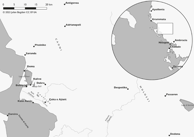
In the context of the joint archaeological project in Çuka e Ajtoit (Albania) by Sapienza University of Rome and the Albanian Institute for Archaeology, new archaeological field research is being conducted in the Southern fringes of the Albanian territory. The area of interest extends from the site of Butrint (UNESCO Heritage site) to the Albano-Greek border, and corresponds to ancient Cestrine, renowned in the literary sources for its pastoral resources and Trojan connections. The study integrates the freshly acquired information collected during the field campaigns, characterized by a high degree of technological innovation, with old research data poorly published up to present. This paper concerns the photogrammetric processing of historical aerial imagery acquired for mapping purposes by the Italian Military Geographical Institute (IGMI) in the 1930s, during the war context of the invasion of Albania by Fascist Italy. The process resulted in the creation of a DTM and an orthomosaic by using SfM algorithms and GNSS topographical surveys, representing the shape of the landscape of the late 1930s, i.e., before the realization of extensive land reclamation programs by the socialist regime that have determined the radical changes of the current landscape.
This volume contains the papers presented during the Meeting ‘Off the Beaten Track – Epigraphy at the Borders’, the sixth in a series of international events planned by the EAGLE, Europeana network of Ancient Greek and Latin Epigraphy international consortium.The Meeting was held on 24–25 September 2015, with the support of the Department of Classics and Late Antiquity Studies at the University of Bari Aldo Moro (Italy). During the event, the EAGLE Portal (http://www.eagle-network.eu) was officially launched and presented to the public for the first time. The event was intended to address the issues which arise in digitizing inscriptions characterised by ‘unusual’ features in comparison with the epigraphic norm. Here are collected contributions from several ongoing digital projects raising questions and proposing solutions regarding encoding inscriptions – from the Archaic period to the Middle Ages and beyond, even in languages other than Greek and Latin – which do not fall within those labelled as standard. The projects involved are the following: ILA – Iscrizioni Latine Arcaiche; The Ancient Graffiti Project; DASI – Digital Archive for the Study of pre-Islamic Arabian Inscriptions; EDB – Epigraphic Database Bari; EDV – Epigraphic Database Vernacular Inscriptions; AshLi – Ashmolean Latin Inscriptions Project.
Thephotometric stereo method is extended to four-source photometry for obtaining 3-dimensional shapes of visually textured and specular surfaces from intensity values. The table look-up approach (based on reflectance maps) for determining surface normals is shown to be of limited value in this context and a more direct method of computing these normals is used. Our method also eliminates the requirement of a preliminary system calibration procedure. The method is applied to real images as a test of its applicability.
This Master’s thesis documents and interrogates networks of regional interaction in southwest Asia and Anatolia during the Neolithic and Chalcolithic periods (12,000 - 5700 B.P.) by comparing the variable use of obsidian raw material variants at 151 sites. This represents an effort to bring together all of the obsidian sourcing data produced for this broad archaeological setting, and evaluate it from a heterarchical approach that highlights the distributed nature of regional interaction. Heterarchical perspectives are applied here through the use of network analysis in order to highlight clusters of sites that are more connected to each other than they are to others in the system, and to determine the roles of each site in the system’s overall structure. As such, order is highlighted as a result of the organization of data-driven ties among sites, which are unrestricted by presumptions relating to geographical position or of pre-defined rank. The results are compared with more established models of regional interaction in the settings of interest, and heterarchical perspectives through network analysis are shown to complement common understandings of broad-scale connectivity at various points in time.
The study of the phenomenon “obsidian” has long made possible to address the interactions between geographically and culturally distant groups. The accumulations of data concerning the prehistoric obsidian in the Middle East and Transcaucasia, as well as the development of new techniques for physicochemical characterization have created a considerable and very diverse amount of information. Obsidatabase is a project for collecting and consulting geological, geochemical and archaeological data related to prehistoric obsidian in this region, facilitating access and sharing of information, and their export to Geographic Information Systems.,L’étude du « phénomène obsidienne » a depuis longtemps permis d’aborder les interactions entre groupes géographiquement et culturellement distants. L’accumulation des données concernant l’obsidienne préhistorique au Proche-Orient et en Transcaucasie et le développement de nouvelles techniques de caractérisation physico-chimiques ont permis la création d’une quantité considérable d’informations de natures diverses. Obsidatabase est un projet permettant la collecte et consultation de données géologiques, géochimiques et archéologiques liées à l’obsidienne préhistorique dans cette région, facilitant l’accès et le partage des informations, ainsi que leur exportation vers des Systèmes d’Information Géographique.
The aim of the study is to observe the random distribution of graves, characteristic of Greek cemeteries in the archaic period. Of the three computing tools that were used, only the data analysis is explained here. The results were displayed in the topographical space, using the x,y coordinate of each grave. The definition of archaeological variables designated to data analysis has increased through the analysis of the vocabulary used by the archaeologist. Correspondence Analysis was used for the study of grave goods, and Multiple Correspondence Analyses for the study of burials characterised by the grave goods structure of the previous analysis. This report concerns one aspect of the results: the 178 child burials described by the archaeologist. The study shows four groups characterized by different archaeological patterns. Each group was inserted in the topography of cemetery. The internal outlines delimited by the groups are the components of the distribution model. The last result is extended to include other structures concerning the archaeology of death.
, World history is often framed in terms of flows of people: humans coming ‘out of Africa’, the spread of farmers in the Holocene, the disruptions of the ‘Sea Peoples’, or ‘colonisation’ by Phoenicians, Greeks and Romans. In this article, the authors argue that world history is also about the flows of objects. To illuminate the impacts of objects on past societies, they introduce the concept of ‘objectscapes’ as a means of writing new kinds of histories of human-thing entanglements, in which objects in motion have roles to play—beyond representation—over both the short and long term. To illustrate, they present examples from two regions at the end of the first millennium BC: southern Germany and northern Syria.
NFDI4Objects (N4O) represents a broad community dealing with material remains of human history from around 3 million years and involves numerous disciplines from the humanities, cultural studies and natural sciences with an archaeological and historical focus [1]. The objects examined include potsherds of common ware, artworks such as sculptures or jewellery, serially produced objects such as coins, organic remains such as wood, bones or pollen, inscribed clay tablets, papyri and stones, architectural remains, as well as human-modified landscapes. Modern research materials such as plaster casts, analogue photographs and drawings, archival documents, books and raw digital data are equally relevant.
Context From June 2020 to February 2021, a consortium of 10 organisations undertook a large-scale study on open access journals across the world that are free for readers and authors, usually referred to as “OA diamond journals”. This study was commissioned by cOAlition S in order to gain a better understanding of the OA diamond landscape. Presentation The study undertook a statistical analysis of several bibliographic databases, surveyed 1,619 journals, collected 7,019 free text submissions and other data from 94 questions, and organised three focus groups with 11 journals and 10 interviews with hosting platforms. It collected 163 references in the academic literature, and inventoried 1048 journals not listed in DOAJ. The results of the study are available in the following outputs: Findings Report - DOI: 10.5281/zenodo.4558704 Recommendations Report- DOI:10.5281/zenodo.4562790 References Library - DOI: 10.5281/zenodo.4562816 Journals Inventory - DOI: 10.5281/zenodo.4562828 Dataset - DOI: 10.5281/zenodo.4553103 Key Recommendations: Streamline technical support Ensure compliance with Plan S Build capacity Increase effectiveness Sustain and invest in the future Kick-start actions: Prepare an International Workshop and Symposium on OA diamond within 6 months to initiate a global conversation among different stakeholders Set up an OA diamond Funding Strategy within 1 year to implement funding recommendations Build the OA diamond Capacity Center within 2 years to support the implementation of recommendations
Context From June 2020 to February 2021, a consortium of 10 organisations undertook a large-scale study on open access journals across the world that are free for readers and authors, usually referred to as “OA diamond journals”. This study was commissioned by cOAlition S in order to gain a better understanding of the OA diamond landscape.
Here is proposed a Photogrammetric technique known since a long time as Photometric Stereo, as cheap and easy technique for taking 3Ds of rock art engraving and relieves. Unlike stereoscopic or monoscopic photogrammetry, this technique uses a standard reflex camera fixed in the same point of view for each shot, under different lighting direction. The image processing gives back three images: the x and y gradients and the “albedo”, which is the surface real color without any shading interference. The 3D surface is recreated from the gradient maps, with good results comparables with the ones taken from the laser scanner, and a very natural appaearance thanks to the Albedo recovery color. The exceptional acquisition aptitude and preservation of the 3D information even under non-ideal conditions and arduous locations is the crux of this technique This presentation is focused on the considerables improvements recently achieved in application modes, execution times and quality results. As example, here are presented the results in XV grave of the Sos Furrighesos’ necropolis in Sardinia.
Il volume raccoglie cinquantaquattro contributi di colleghi, amici ed allievi di Orlanda Pancrazzi, per lunghi anni docente all'Università di Pisa, come segno di omaggio per la conclusione del suo insegnamento. Il titolo, "Archaeologica pisana", non deve trarre in inganno, dato che nasce essenzialmente dal fatto che la festeggiata ha svolto il suo curriculum accademico nell'Ateneo di Pisa e molti degli autori le sono stati colleghi o discepoli. I contenuti dell'opera non sono però circoscritti a Pisa ed al suo territorio, dilatandosi anzi in un arco tematico assai esteso, con un vasto spettro di ambiti disciplinari che, nella loro assortita articolazione, riflettono la varietà delle relazioni di Orlanda Pancrazzi.
This article describes the results of a project related to IT applied to the city of Lucca in the Roman era (Tecnologie informatiche per la conoscenza e la comunicazione di Lucca romana), which was conducted as part of a Ph.D. program in Technologies and Management of Cultural Heritage at the Institute for Advanced Studies IMT Lucca. The work done can be divided into three separate stages, each of which is distinguished by the utilization of specific surveying tools. The first to be set up was GIS LUCA (Looking at an Urban Context Archive), where all the existing documentation on Roman Lucca was archived (maps, iconography, surveys, images, descriptive data). The information processed in LUCA provided data for the creation of the three-dimensional model of Roman Lucca, whereby the walls, main monuments and arteries, which still identify the town as Roman today, are represented in a schematic yet scientifically correct way. Additional experimentation was conducted as part of the research. Using an innovative three-dimensional relief technique, the ZScan, which enables cloud points to be taken from a photographic scan, three-dimensional models of the pillars of the eastern gate were elaborated, as well as three arches of the Roman amphitheatre that have been particularly well preserved. Lastly, the website www.luccaromana.com was created to publish the results that were obtained. The site proposes numerous knowledge paths around the ancient town by means of a range of highly innovative access methods, that provide a global yet synthetic description of Roman Lucca, which is a result of the research and experimentation conducted as part of the project.
After describing the distribution of funerary contests in ancient Numana, this contribution considers funerary architecture, particularly circular formations and the most monumental tombs, passing then to examine aspects of the funerary ritual in its main articulations. The second part of the contribution concerns methodology and the first results of the ongoing project in the Davanzali necropolis, outlining the future research perspectives. Dopo un inquadramento sulla distribuzione dei contesti funerari di Numana antica, si passa a considerare l’architettura funeraria, e specificamente i circoli e le manifestazioni più monumentali delle necropoli. Si approfondiscono inoltre aspetti del rituale funerario nelle sue principali articolazioni. La seconda parte del contributo è incentrata sulla metodologia e sui primi risultati del progetto in corso sulla necropoli Davanzali, con indicazione delle principali linee di ricerca future.
Starting from the criticisms recently levelled at the so-called paganic-vican model of settlement and its alleged pre-Roman origin in the areas of the Central Apennines, the author points out that according to Verrius Flaccus – Festus (502 and 504
This paper provides a short summary of some recent results in intrasite spatial analysis in Prehistoric archaeology and, in particular, in Paleolithic archaeology where, as it is well known, intrasite spatial analyses have been applied for at least twenty years. Starting with some “classic” examples of 80’s (the Magdalenian site of Pincevent, the ethnoarchaeological analysis of the Mask site in Alaska), and a short illustration of the techniques applied (correspondence analysis, k-means cluster analysis, unconstrained clustering, factor analysis, etc.), some of the most recent applications are described: the Mesolithic Barmose I site in Denmark, studied by H. Blankholm, and the Middle Pleistocene site of Grotte Vaufrey in South West France (Dordogne), where the intrasite spatial analysis has been performed by J. Simek. We then discuss the relationship between the “quality” of the quantitative procedures used in the data analysis, which is in general of an outstanding level, and the “reliability” of the archaeological interpretation. A major conclusion is that the problems arising in the archaeological interpretation (a good example of which is Grotte Vaufrey) are much more connected with the choice of variables in the quantitative analysis, than with the different algorithms employed: we thus recommend to the archaeologists (and not to the computer scientists involved in the research) the basic selection and choice of the essential variables derived from the data.
With this contribution we want to show how acquisition, management and analysis of the three-dimensional component of archaeological data can improve the understanding of the formation of different contexts and, in particular, the construction history of a historic building. The introduction of a new generation of lighter and cheaper 3D laser scanners and the dissemination of web service, open source and low-cost software for digital photogrammetry have triggered a debate about their proper use in archaeology. Previous research has left a number of problems open and the proposed solutions cannot be considered yet fully satisfactory. In the first part of the article we will outline the limits of the current standards of archaeological documentation and describe the possibility of integration of these new tools into the operational practices, with particular emphasis on photogrammetry. In the second part we will propose an example of archaeological analysis of the Nuraghe of Tanca Manna (Nuoro) using unconventional methods and tools: a system of shooting on telescopic pole (featuring remote control of the camera to the ground and preview frame); the combined use of free cloud computing and commercial software for automatic modeling of architectural surfaces; a dedicated electronic procedure to document the wall stratigraphy and the shape of the structural elements on the 3D model; data management in a GIS environment; the use of PDF3D as standard format for the exchange and use of three-dimensional content. In conclusion, we will attempt to demonstrate the added value of this workflow compared to the normal operating procedure, emphasizing the versatility, speed of execution and the improved information content of final papers.
This paper focuses on a survey of the Predictive Archaeology domain, including a review of its key developments since the 1960s. A working and minimalist definition of Predictive Archaeology (P) - which becomes Preventive Archaeology in its application, that is, when it is expressed through the quantification of the risk of archaeological impact - may be that of a prediction technique for locating archaeological sites in terra incognita, based on a sample of known sites (terra cognita) or on assumptions about human location/allocation behavior in the past. A prospective view of possible short-term evolutionary scenarios is also illustrated.
L'associazione culturale ArcheoCasarano "Origini e Futuro" ha finanziato in larga parte il progetto editoriale con un contributo della città di Casarano, in provincia Lecce. Se nei due precedenti lavori sulla chiesa di Casaranello abbiamo descritto l'attività di gestione e valorizzazione del monumento, approfondendo il significato dei mosaici tardo antichi e unendone la narrazione delle pitture a fresco presenti nell'edificio, in questa nostra terza pubblicazione, indubbiamente di taglio più tecnico, ci concentriamo su due temi ancora oggi molto dibattuti: la tipologia architettonica originaria dell'edificio sacro e l'interpretazione di un affresco identificato da Francesco Danieli nell'immagine di Costantino il Grande. Il lavoro che vi presentiamo, dunque, è di estrema importanza poiché lo studio dell'impianto architettonico del monumento è un punto chiave per la comprensione dell'intero sito di Casaranello, presupposto necessario per una lettura consapevole delle opere e dei lavori in esso contenuti; proprio nella natura architettonica di una fabbrica, infatti, è celato il suo significato più profondo. Per questo motivo, i numerosi autori che si sono occupati della chiesa si sono cimentati nella sua esegesi architettonica proponendo, nel corso del tempo, varie interpretazioni.
Numana is one of the most important centers for the Picenian civilization and prospered in the Marche and Abruzzo regions during the Iron Age. Almost all of the archaeological evidence found until now refers to the necropoleis spread over a broad territory, while data concerning inhabited areas are quite scarce. Although findings are plenty, the study of Ancient Numana is quite incomplete. As a matter of fact, all the published materials are related to single burials or finds and there are no overall studies on its territory. A recent research project involving a wider sector of the largest Numana necropolis (Quagliotti-Davanzali), has not been published yet but offers a detailed description since the excavation documentation is available. The project sets out to consider burials as organized systems, offering information on cultural transformations and on the social organization of the ancient community. The systematic analysis of the data from the burial and the single funerary sets - to be organized in a specific GIS - will be accompanied by an investigation of the ancient landscape in its many components - necropolis and inhabited area - in its diachronic development, thanks to the results of other recent analyses carried out in the Numana territory (geomorphology, GIS of the archaeological map, new surveys of the territory). The scope of the project is therefore to analyze times, ways of arrangements, shapes of the Ancient Numana, in its definition of a territorial, inhabited, rural space, by using methods and techniques to record and read new data, to build knowledge in a scenario which can be integrated with results coming from future research.
L'articolo presenta i primi risultati del progetto sulla necropoli picena Quagliotti-Davanzali di Numana. Lo studio si concentra sul processo di occupazione dell'area funeraria e sulle modalità di sepoltura, che variano nel tempo. La ritualità funeraria è analizzata considerando la composizione e l'associazione dei corredi. Questo approccio ha permesso di acquisire nuovi interessanti dati per la comprensione del ruolo che dovette occupare Numana nel Mar Adriatico.
This contribution originates as part of a preliminary work initiated in the site of Saepinum – Altilia (CB, Molise), which is still waiting for a scientific edition of the excavations, despite the latter having started in the ninety-fifties. It specifically focuses on the macellum building, whose problem-prone aspects are still high in number, such as the fairly relevant issue of establishing chronological phases. With regards to the various secondary issues, though not less interesting, we'd like to draw the attention to a big circle-shaped stone block placed at the heart of the building which is open to several interpretations (water reservoir of a fountain? grinding wheel of a crusher?), in order to examine the various possible solutions to the issue and appreciate how real its belonging to the building is.
Research on settlement dynamics is mainly based on data from archaeological field survey. This exploration method gives access to a large amount of information that enables to identify distribution tendencies and to establish a model of evolution of the settlement structure at different scales. Nonetheless, field survey data, even if chronologically dated, provide a partial record and a snapshot of the settlements. This static information lacks a certain number of parameters, which are essential to perceive the inherent evolution of the settlements and therefore to visualize it within the dynamics of the settlement trajectory networks. On the other hand, data from archaeological excavations enables to detect those phenomena. This paper proposes a methodological approach to use information collected during excavations in order to qualify and reinforce the analysis of the dynamics that rely on elements from field survey. While studying the dynamics of the settlement system during Antiquity in the Plateau lorrain (France), the use of evolving data from excavations offers solutions which balance and improve the static approach stemming from field survey data.
Visibility analysis has become extremely popular in landscape-oriented archaeology in recent decades and has become even more widespread with the popularization of GIS tools, which have multiplied the ways in which visual perception can be analysed and digitally modelled. Visibility has been used as a proxy for different archaeological approaches, from the analysis of subjective perception to the assessment of strategic control. While interest has most often been focused on how objects, features and sites are perceived, there has also been an interest in how visual control is exerted from archaeological sites or other places in the landscape. Within the latter approaches, the distances at which visual control can be exercised have usually been determined in a more or less arbitrary manner, without a clear and empirically informed reference on how things and, especially, people can be observed and recognized differently at a distance. In this paper, we present the results of a field experiment carried out to measure the distances at which individuals can be spotted, recognized and identified with the naked eye in favourable conditions. Based on these results, we introduce the concept of Individual Distance Viewshed (IDV) as a GIS-based representation of visual control. This will serve as a reference to better qualify potential visibility in landscape analysis. Finally, we illustrate the applicability of this approach with a case study which explores the relationship between visual control and mobility during the Iron Age in the NW of the Iberian Peninsula.
LiDAR technology has significantly advanced archaeological prospection, but its potential has been limited by the availability of data, as these are often collected through regional or state campaigns aimed at landscape and environmental mapping rather than archaeological research. Although LiDAR has been widely applied in Italy, partial coverage has left significant areas unexplored, including Emilia-Romagna (RER). Notably, RER launched a new LiDAR mapping campaign in 2022, starting with six test areas. Two of them, the Vena del Gesso Romagnola and Valmarecchia, were selected to assess the potential of the novel RER LiDAR-derived DTMs, which have 0.5m resolution and comprehensive coverage, compared to earlier national MASE/MATTM DTMs with lower 1m resolution and incomplete coverage. The analysis of RER DTMs revealed site layouts, standing remains, and partially buried features across seven medieval castles, including many structures previously unknown in national data and not recorded by earlier field surveys. Higher resolution and full coverage of RER DTMs proved to be especially valuable for hilltop sites, so it is hoped that RER will fund additional mapping campaigns to achieve complete regional coverage. Meanwhile, newly acquired datasets from 2023 and 2024 offer valuable opportunities to further advance archaeological research in the region.
The author analyses new methodological trends in the nineties, concerning the evolution of quantitative techniques, and the development of computerised tools. The main role in archaeology of institutional changes and the influence of theorical approaches in Human Sciences are analysed, in order to discover a third way in archaeology.
Sites with towers in eastern Arabia have been interpreted as regional centres of the Early Bronze Age. One of those sites is Al-Khashbah in central Oman. Until now, however, nothing was known about its hinterland that would support the idea of a regional centre. The Al-Mudhaybi Regional Survey was therefore initiated in order, for the first time, to provide comprehensive and detailed knowledge of this third-millennium BC landscape. This paper presents the results of the remote sensing and ground truthing of potential features in the 2019 field season. Nearly 4000 archaeological structures ranging from the Neolithic to the modern era have been positively identified. Interestingly, some periods such as the Hafit and Wadi Suq were abundantly present, while the Umm an-Nar and Late Bronze Age were almost totally missing. It is also important to note that, except for the possible Hafit-period tower at Al-Fath, no Bronze Age settlement sites were found. The reasons behind this pattern remain to be discovered.
Recent work, in the field, on the dimensions and weights of loomweights from excavations in Insula VI.I, Pompeii suggested that there was structure in the form of evidence of bi-modality in the weights. The paper has two purposes. One is to illustrate a variety of statistical methods that were used to confirm the validity of our observations. The other is to discuss what the archaeological implications of this might be. A more general point is that if more attention is given to what are often regarded as “uninteresting” artefacts some interesting results may emerge - specifically, it can be asked whether loomweights have chronological significance for interpreting archaeological sites (at Pompeii at least).
The notes that follow are the first results of a programme of field-survey undertaken by the writer and by various members of the British School during the autumn of 1954 in the area that lies immediately to the north of Rome, between the Tiber and the sea. This area is one that has been strangely neglected by modern students of Italian topography. Ashby's published work is concerned mainly with those parts of the Campagna that lie to the south and east of Rome; and Tomassetti's work, invaluable as a repertory of manuscript and published sources, lays no claim to be a comprehensive survey of the material remains surviving on the ground. Such a survey is badly needed today. The romantic desolation of Southern Etruria is being transformed from one day to the next under the impact of a scheme of landreform comparable in scale to the great reforms of classical antiquity, and vast estates which for centuries have been used for stock-breeding and seasonal pasture are being broken up and brought into cultivation with all the devastating thoroughness that modern mechanical equipment entails. Whole regions are accessible today as they have never been before, and within them the bulldozer and the mechanical plough are busy destroying whatever lies in their path.
Methodological and statistical aspects of the distribution of Greek imported ware in the archaic period (600-480 a.C.) in Salento are presented here. They form part of a wider research on trade. In order to value the fieldwork intensity and assess the survival conditions of archaeological data, the contexts to which the finds can be provenienced have been analysed. Frequencies of type concerning recovery of artefacts (occasional recovery, systematic excavation, survey, underwater and unclassified), frequencies of contextual types (settlements, cultual places, isolated graves, necropolis, unclassified and anchorage) and frequencies of the exploration degree in the archaeological sites have been studied. Crosstabulations between these classification factors and the quantities of material found in each context have been conducted. These analyses permit us to identify similar contexts from the point of view of archaeological research and to value more fully the phenomenon of interaction and exchange in the Salentine peninsula in the archaic period. Regression analyses were also conducted to study the distribution of Greek colonial ware.
This paper examines several issues relating to the history of Roman Hirpinia in the light of epigraphic documentation now available. First, the author outlines and compares the different aspects of the social, economic, and institutional history of
Tra le numerosissime ceramiche attiche restituite dalle necropoli spinetiche, non sono pochi i vasi degni di particolare interesse e di questi alcuni sono veri pezzi unici per qualità artistica, per dimensioni, per forma, per decorazione figurata. Tra questi vasi è lecito annoverare un raffinato cratere a campana del Pittore di Altamura datato attorno al 460 a.C., un pezzo di eccezionale qualità la cui decorazione figurata rappresenta un unicum nella produzione ceramografica attica conservata.