In this fully revised and updated edition of Roman Pompeii, Dr. Laurence looks at the latest archaeological and literary evidence relating to the city of Pompeii from the viewpoint of architect, geographer and social scientist. Enhancing our general understanding of the Roman world, this new edition includes new chapters that reveal how the young learnt the culture of the city and to investigate the role of property development and real estate in Pompeii’s growth. Showing how Pompeii has undergone considerable urban development, Dr. Laurence emphasizes the relationship between the fabric of the city and the society that produced it. Local activities are located in both time and space and Pompeii’s cultural identity is defined. This book is invaluable for students and scholars in the fields of archaeology and ancient history, as well as being rewarding reading for the many people who visit Pompeii.
The Roman colony of Savaria was the first founded town in Pannonia (Colonia Claudia Savaria). Some inscriptions attest the so-called ‘deductio’, the settlement of veterans. After the first reconstruction of the centuriatio of Savaria no substantial archaeological attempt has been made in the last 40 years to verify the theory. In the last decade, research into the existence of the Savarian centuriatio has been pursued by using GIS methods, thanks to which we have managed to build a predictive model-network for the centuriatio, which is completely different from the previous reconstructions. The model has been continuously refined and validated by archaeological fieldwork and geophysical survey. The new reconstruction has led to new possibilities for interpreting the sites excavated in recent decades and the previously known Roman roads and aqueducts. Another interesting relationship between the watercourses running through the former colonia and the Roman centuriatio was also detected: the impact of Roman agriculture on the landscape transformation that has survived to the present day. Our pilot project, launched this year, plans to verify these effects using multispectral UAV surveys and geophysical measurements to show whether there were former streams along the presumed Roman channels that could provide evidence to support this hypothesis.
Methods to document rock art in all three dimensions have become a standardized workflow. In this article, we discuss their advantages and disadvantages when compared to older reductive approaches to rock art documentation. Furthermore, some misunderstandings regarding 3D documentation are addressed. As the majority of the problems presented by the 3D documentation of rock art can be solved through advanced visualization workflows, recent developments in this area are described. The rock art documentation described in this contribution also serves wider research purposes, which will be discussed. Newly discovered images and newly developed machine learning algorithms will also be introduced.
This thesis examines the physical evidence for ancient bridges and roads in the three most eastern provinces of the Roman Empire. Its focus is the two and a half centuries before the Arab invasions when population reached a peak. It uses satellite photographs from Google Earth to place the roads in a geographical context and contains many maps. The thesis describes twenty-four stone bridges in the provinces concerned which are thought to date from the Roman period and contains photographs of these where possible. Field research has included a large number of visits to SE Turkey and two visits to Syria. On the basis of the material evidence and the ancient sources, in particular the Peutinger Table (which are discussed in a specific chapter), the thesis examines the course of the roads and their users; it also addresses the reasons for construction of the roads, together with associated issues such as the disappearance of wheeled vehicles. The thesis describes the ancient cities, the settlement pattern and the fortifications of this region, which lay on a much troubled frontier with frequent warfare between Rome and Persia. It discusses how warfare and the construction of fortifications modified the nature of the region in the sixth century AD and then examines issues arising from the existence of the road network such as defence of the frontier, trade and the impact that commercial and social links, as well as the road network itself, had on relations between the two great empires of Late Antiquity. Annexes short reviews of archaeological work in the area and of medieval and modern travellers who have passed through it. A gazetteer of cities and fortresses mentioned in the text is attached at the end.
Twelve papers by leading international scholars on the theme of the cultural, regional and personal identity of the Etruscans. The volume celebrates the originality of the Etruscan character manifest in its richly varied workshop production, and examines some unusual objects and buildings, considering what they tell us of Etruscan life, belief and influences. On a personal note, it considers how the Etruscans themselves wished to be identified and remembered. Two contrasting papers discuss attitudes to the Etruscans in the 18th century and the latest evidence for their origins using DNA studies. The papers were originally presented at a conference in 2006, celebrating the work of the renowned Etruscologist, Sybille Haynes.Table of ContentsSybille Haynes mbe in her own words Bibliography Foreword (Neil MacGregor) James Byres and the Definition of the Etruscans (David Ridgway) The Hamilton Gray Vase (Dyfri Williams) The Ridgway Ram Vase (Dyfri Williams) An Attic Red-figure Kylix from Veii and the Distribution of the Zalamea Group in Etruria (Laura Ambrosini) The Importance of Being Umaele (Giovanna Bagnasco Gianni) The Late Orientalising Bronze Workshops at Chiusi (Antonella RomualdiShake) Rattle and Role? Sistrums in Etruria (Judith Swaddling) Houses, Tombs and Temples (Friedhelm Prayon) Etruscan Rock-cut Chamber tombs (Stephan Steingräber) Solving the Riddle of the Sphinx on the Roof (Nancy A. Winter) Funerary Practice, Rituals and Ideology of the Orientalising Aristocracies (Stephano Bruni) The Lotus and Poppies in Etruscan Funerary Contexts (Jean-René Jannot) The Etruscan Language in its Italic Context (J.H.W. Penney) Etruscan by Definition (Phil Perkins)
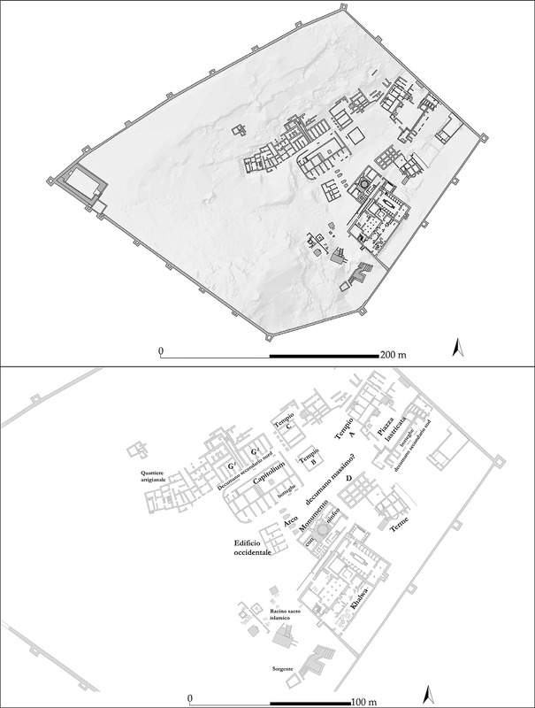
Since 2016, the Italian Mission to Oman in collaboration with the Office of the Adviser to His Majesty the Sultan for Cultural Affairs started a new project on the Inqitat promontory in the Khor Rori area (Dhofar, Oman). These archaeological investigations have brought to light a huge settlement that provides important data on the first millennium BC in Dhofar. The materials studies and the radiocarbon dating suggest that the settlement was used until the Classical Period (1st-2nd cent. AD), contemporary at least in part with Sumhuram. This was an important South-Arabian city strongly connected with the frankincense trade. The site of Inqitat seems to suggest the presence of a long life architectural tradition, and open some interesting questions about the relation between South Arabian people, who were living in Sumhuram, and the local population of the area. Furthermore, this site could allow some understanding of the culture of the inhabitants of Dhofar.
Si comunicano i risultati delle ricerche degli ultimi anni ( 2013-2015) nella grotta del Sambuco. I nuovi scavi hanno interessato i livelli preistorici sottostanti una serie complessa di sottili livelli storici, riferibili ad un arco di tempo che va
The paper approaches the rights of reproducing Cultural Heritage items, in every possible aspects and for both commercial and non-commercial purposes. The legal situation is currently vague and not defined, as it is in other parts of Europe and the world. Two valid arguments are confronting each other: on the one hand, the public demand for data openness, on the other, the public institutions’ desire to earn money, at least enough to justify conservation expenses. After a discussion on the current situation, where digital revolution and 3D technology changed even the common understanding of ‘reproduction’ processes, a possible solution is presented, in order to satisfy both needs.
While the application of computer technology to archaeology has been characterized by numerous experiments, there has been no specific attempt to standardize processes. Archaeologists operating in the field seem to privilege “ad hoc” solutions in which the computer has been more or less actively featured. Without any pretence of presenting a model, this paper describes a series of field experiments conducted by the archaeology team of the University of Foggia, and reflections based on the growing use of computers in the various phases of our research. Beyond this, we hope to show the necessity and importance of reaching some kind of consensus regarding methodology and technological innovation. Computer technology has allowed us to rethink the process of documentation by introducing important innovations in all phases of research, from recovery of data to analysis, interpretation and reconstruction right through to the dissemination of results.
The study of the Attic-figured pottery is closely connected to the “Beazley method”, which consists in the possibility of recognizing a painter’s hand exclusively on a stylistic basis. Although it has suffered some criticism, the Beazley method is still considered substantially valid. The need to collect images which can be analyzed from a stylistic point of view convinced us to combine 3D photogrammetry (Agisoft Photoscan) with 3D modelling (Luxology Modo) software in order to transfer the figured frieze from a vase to paper, thus avoiding the limitations of traditional direct drawing. These tools allowed us to contribute to the debate on the Beazley method; in fact, new research showed that Beazley over-divided Attic pottery, identifying many more painters than actually existed. This paper deals with the potential of 3D modeling applied to the Attic-figured pottery and focuses on the case of the Painter of Syracuse 19861, to whom Beazley attributed only two lekythoi (both belonging to the Lauricella collection from Gela and today displayed in the Archaeological Museum of Syracuse). The use of the 3D modelling process allowed us to obtain images proving that the two objects belong to the Ethiop Painter’s final production instead of to a different painter.
The paper analyses the practise of surveying and reconstruction of the buildings in a Roman North Africa monumental centre by means of photogrammetry and three-dimensional modeling. Photogrammetry, in particular, proves to be an efficient and economic method for field analysis, although it has limitations in terms of processing time and the need for very powerful computers. Photogrammetric models, characterized by a high volumetric and colorimetric quality, constitute an ideal basis for reconstruction by means of 3D modeling, particularly in the case of research, such as this one, related to the Archaeology of Construction.
The architectural survey for the restoration of a monument is closely linked to the conservation objectives, the research methodology, and the application of multiple direct an indirect investigation techniques for the construction of adequate geometric and informative models. In particular, the paper aims to understand and evaluate a building from its structural characteristics, developing a methodology that, from the geomatic survey, deconstructs the building itself into elements and articulates them in a HBIM platform, which integrates a set of five semantic models representing the architectural components and construction abaci. The approach applies this survey method and modelling workflow to the study of some post-Byzantine monasteries in Albania with a focus on the structural conditions of the church of S. Maria in Goranxi that presents problems of instability due to phases of expansion and over construction.
Different conflicting ideas and values cross the debate about freedom of access to cultural heritage. This is nothing new: a similar debate arose in the past decades with confrontation among free software and proprietary software. The future will depend on the evolution of this cultural conflict and the political choices that will follow.
The last few years have witnessed an upsurge in archaeological and historical studies of the Adriatic, with the creation of a few major projects and an increase in analytical publications. Sometimes considered to be relatively marginal in the light of Roman political and economic development, the sea became ever more fundamental to late antique and medieval commercial geography with the establishment of the new capital at Constantinople and the gradual breakdown of the old Roman communication system and markets. With the eventual loss to the Empire of much of the Italian peninsula following the Lombard invasion in the late 6th century, the Adriatic developed as a preferential route linking the Aegean and the entire Byzantine world with northern Italy, the Rhine corridor, the north-western Balkans, and beyond. From the perspective of someone living and working at the entrance to the Adriatic, not far from the ports of Brindisi and Otranto, I intend to examine how the study of ceramics is helping us to understand the complex dynamics of changing relations between late antiquity and the early Middle Ages. I hope to illustrate some of the things that have been achieved in recent years, as well as to indicate directions for future research.
The villa-complex of Theodoric in Galeata is one of the latest examples, at least within the Italian peninsula, of the great private residences of late antiquity. The site is multi-layered and has evidence of seventeen centuries of occupation, from the 6th century BC to the 12th century AD Important new knowledge of the pre-Roman (a settlement of the Late Iron age) and Roman (a large villa) phases of the site has been acquired. The most significant results, however, concern the late antiquity phase. The excavations, in fact, have led to a new interpretation of the complex known as the ‘Palace’ or villa of the Goth king Theodoric. In this long-running excavation it has been possible to test the transformations of excavation methods and techniques, which have evolved over the years.
The article presents some aspects of the research project which has been carried out in the middle Tiber Valley (Sabina Tiberina), to analyse the distribution of archaeological sites in the territory, based on new field surveys and the study of archive documents ('Progetto Galantina'). The research takes advantage of the positive experiment conducted by the Istituto di Studi sulle Civiltà Italiche e del Mediterraneo Antico (ISCIMA) of the Italian CNR to set up and integrate within a Geographical Information System a new model of archiving, managing and querying archaeological information, focused on the analysis of excavation diaries and their SGML and XML encoding. The implemented system gives rise to a many-sided repeatable digital model, easily exportable in various situations. The integration between the DTD established to formally describe archaeological data and the elements of the TEI Lite and Dublin Core standards makes it possible to record and query data coming from both published excavation reports and archive documents dating from the nineteenth century, which deal with the description of archaeological itineraries around Rome. The example presented in this paper refers to the manuscript by Ercole Nardi 'Ruderi delle Ville Romano-Sabine nei dintorni di Poggio Mirteto' (1885) and is aimed at preserving archaeological information through digital supports, electronic exchange formats and especially reliability of the information integrity. Moreover, it makes an attempt to experiment and develop new forms of knowledge diffusion which are more suitable for interactive web consultation than passive reading.
The island of Sant&; Andrea, situated on the road that since ancient times has linked the Adige Valley with the Lake Garda, once rose impressively from the green expanse of water, but now is a small hump on the edge of a vast marshy basin. Fifteen centuries ago it was the fortified seat of a contingent of soldiers and their families. In 1998, after a long series of sporadic discoveries that started way back in the 19th century, the Archeaology Section of the Rovereto Civic Museum began a research and study project that involved a series of summer excavations, that brought to light a multi-layered archeological site with finds ranging from the prehistoric age to late antiquity, medieval times and right through to even the First World War. Along the northeastern side and the southern edge of the island the remains have been found of some buildings that can be traced to a fortified settlement and on the top part of the hump the remains of a Romanesque church have been investigated. The buildings that made up the settlement illustrate a complex series of construction periods; so far these have been dated between the 5th and 7th centuries. Numerous examples of armoury and military clothing have been found in the settlement area and this clearly suggests the military function of the site. The volume is devoted to the results of the research in the castrum: A general overview of the site is followed by a part devoted to periodization and stratigraphic analysis of the dig; then there is a large section that includes contributions on the small finds; the fourth part contains some concluding remarks.
Un'eccezionale raccolta di oggetti realizzati in questa preziosa resina fossile. Si chiude così il ciclo di grandi mostre Un anno al Museo Archeologico Nazionale di Napoli dopo Argenti a Pompei e Egittomania. “Uomo spedir d’accorgimenti mastro, che con un bello, aureo monile e d’ambra vagamente intrecciato, a noi sen venne. Madre ed ancelle il rivolgean tra mano, prezzo non lieve promettendo, e a gara gli occhi vi tenean su Omero” Odissea, XV, vv.459-464. L’evento espositivo si propone l’obiettivo di far conoscere al grande pubblico una delle classi più preziose e meno note tra i materiali restituitici dall’antichità, che rivestiva accanto a quello economico, un forte valore simbolico. Affiancando ai materiali di competenza della Soprintendenza per i Beni Archeologici di Napoli e Caserta i prestiti provenienti dalla maggior parte dei musei italiani e da prestigiose istituzioni straniere, l’esposizione presenterà un cospicuo numero di oggetti in ambra, inseriti nei contesti di provenienza, oggetti che consentiranno non solo la costruzione di un quadro il più possibile unitario della produzione artistica e dei percorsi di approvvigionamento dell’ambra, ma anche la comprensione dei meccanismi economici, sociali e rituali alla base della sua distribuzione.
The use of the Extended Matrix in the planning of the Mount Nebo virtual archaeological park allows for the creation of virtual models. The models facilitate the rediscovery and understanding of sites in the surroundings of the Moses Memorial on Mount Nebo that are difficult for tourists to access, ensuring the virtual preservation and memory of these sites. The use of the Extended Matrix as the basis for virtual reconstructions guarantees a philologically correct reconstruction based on reliable sources. The possibility of verifying the sources used and the reconstructive process of the author, at any time, ensures a transparent reconstruction. Sharing this data also makes it possible to have access to large databases that can be implemented and modified over time to keep them up to date.
, Excavations at Çatalhöyük have been ongoing for over 20 years and have involved multi-national teams, a diverse range of archaeological specialists and a vast archive of records. The task of marshalling this data so that it can be useful not only at the post-excavation stage, but also while making decisions in the field, is challenging. Here, members of the team reflect on the use of digital technology on-site to promote a reflexive engagement with the archaeology. They explore how digital data in a fieldwork context can break down communication barriers between specialists, foster an inclusive approach to the excavation process and facilitate reflexive engagement with recording and interpretation.
The settlement—a place on a landscape where a human group lives and interacts—has become such a fundamental social and material concept in archaeology that it is rarely explicitly defined. The breadth of meaning built into the term allows it to transcend regional, temporal, and contextual differences in site form, size, and composition. However, just as this combination of versatility and implied meaning makes settlement applicable to archaeological studies worldwide, it also creates conditions in which the term’s social significance may be overlooked or where it may be misapplied in ways that lead to false equivalencies and mischaracterizations. Through a literary review of research on Umm an-Nar period (UaN; ca. 2700–2000 BCE) sites of the Oman Peninsula, this paper examines the ways in which broad (mis)applications of the term ‘settlement’ can deeply impact scholarly understanding of an ancient society. Inconsistencies in UaN settlement identification—born of regional variations in the archaeological record, coarse temporal clarity, and the history of scholarship in southeast Arabia—are shown to have significant ramifications for how UaN society is analyzed, interpreted, and characterized in archaeological literature. It is argued that settlement-focused archaeological studies would universally benefit from explicit definition(s) of the term and greater precision in its application.
The Monti Aurunci Regional Park, located in southern Lazio, Italy, is renowned for its geological and naturalistic features as well as its archaeological significance. This area hosts a wealth of archaeological sites covering from pre-Roman and Roman periods to the modern era, many of which remain largely unexplored. These sites are currently being investigated as part of the Monti Aurunci Project (MAP, https://www.archeologiadiffusa.org/2022/09/17/ map/), an initiative led by the University for Foreigners of Siena. Among the notable sites in this region is the multi-layered and abandoned hillfort known as ‘Le Mura di Campello’. How- ever, dense forest cover significantly hinders the identification, interpretation, and mapping of archaeological remains in the area. Furthermore, the lack or low quality of existing datasets limits their usability for archaeological purposes. To address these challenges, a drone-based LiDAR survey was conducted in the winter of 2023, yielding high-resolution data that have proven invaluable for archaeological analysis. With an average point density of 142 points per square meter, the LiDAR data facilitated the identification of numerous archaeological features, enriching the understanding of the Monti Aurunci’s cultural heritage. Over 100 previously undocumented features were mapped, including terracing systems, hillforts, dwellings, walls, and road system. The results obtained have refined our understanding of the historical settlement dynamics in the Monti Aurunci area and opened the door to new methodological approaches, offering promising future research directions.
Preservation of digital data is predicated on the expectation of its reuse, yet that expectation has never been examined within archaeology. While we have extensive digital archives equipped to share data, evidence of reuse seems paradoxically limited. Most archaeological discussions have focused on data management and preservation and on disciplinary practices surrounding archiving and sharing data. This article addresses the reuse side of the data equation through a series of linked questions: What is the evidence for reuse, what constitutes reuse, what are the motivations for reuse, and what makes some data more suitable for reuse than others? It concludes by posing a series of questions aimed at better understanding our digital engagement with archaeological data., La conservación de datos en formato digital se basa en la expectativa de su posterior reutilización y aprovechamiento. Sin embargo, esta expectativa nunca ha sido examinada como posibilidad razonable dentro del campo de la arqueología. Aunque contamos con grandes repositorios digitales equipados para compartir datos, los casos claros de reutilización de los mismos parecen ser paradójicamente limitados. La mayor parte de las discusiones sobre estas cuestiones en la arqueología se ha centrado en la gestión y conservación de datos, así como en prácticas de almacenamiento y acceso compartido. Este artículo aborda el tema de la reutilización de los datos en este contexto a través de una serie de preguntas vinculadas entre sí: ¿Qué evidencias o casos de reutilización existen?, ¿Qué constituye realmente una reutilización de datos?, ¿Cuáles son las motivaciones para su reutilización? y ¿Qué comporta que algunos datos sean más adecuados que otros para este propósito? El artículo concluye planteando una serie de preguntas enfocadas a una mejor comprensión de nuestra relación entre el medio digital y los datos arqueológicos.
The Upper Paleolithic (UP) assemblages from the Zagros Mountain range were traditionally assigned to the Baradostian cultural group based on the original definition from Layer C at Shanidar Cave. New chronological information from three UP core areas of the Zagros—the Northern, West-Central and Southern Zagros—points to the roughly simultaneous appearance of UP technological traits in at least the Northern and Southern Zagros, while techno-typological analysis suggests a significant degree of variability among the UP assemblages from different parts of the region. On the other hand, there is considerable evidence that colonization of the Iranian Plateau occurred by different groups of hunter-gatherers that simultaneously occupied different parts of the Zagros and developed their own cultural identity as reflected in their lithic assemblages. This paper describes five UP sites, including Shanidar in the Northern Zagros Mountains, Yafteh, Pasangar, and Warwasi in the West-Central Zagros, and Ghār-e Boof in the Southern Zagros Mountains. Lithic techno-typological analysis from these UP assemblages reveals a more dynamic and complex nature of the UP populations in the Zagros than once thought. This paper hypothesizes that the variability among the UP assemblages indicates a limited interaction between UP populations throughout the Zagros. While Shanidar Baradostian techno-typological characteristics and raw material economy indicate more interaction towards the North, the Rostamian of the Southern Zagros stands in contrast to the UP assemblages from the Lorestan and Kermanshah (LaK) regions of West-Central Zagros. As Shanidar was culturally less connected to the southern parts of the Zagros, the question of the Baradostian as a widespread technocomplex diffusing towards the West-Central and Southern Zagros is debatable. The same appears to be true for the Rostamian cultural tradition in terms of connectivity to the West-Central Zagros, as the Rostamian is widespread throughout the Southern Zagros. Therefore, the homogeneity model of the UP that presented the Baradostian as typical for the entire Zagros is no longer valid and should be reconsidered.
Rethinking Ostia presents an archaeological and spatial approach to Roman urbanism, combining archaeological research with today’s insights into urban planning. Taking the reader along the route of a “spatial investigation” the book offers a new overview and a fresh evaluation of the past society and the built environment of Rome’s leading port city. Following a scalar approach at different spatial ranges, the author examines various aspects of Ostia's urban landscape, applying methods of spatial analysis to individual houses, an entire ‘Insula’-neighborhood, and the street system. A careful reconstruction of the Insula’s development over the first three centuries CE forms the core of the book. The work reveals how everyday life was structured in the city, and how this evolved over time in response to internal and external influences on the lives of the citizens.