Social computing prototypes probe the social behaviors that may arise in an envisioned system design. This prototyping practice is currently limited to recruiting small groups of people. Unfortunately, many challenges do not arise until a system is populated at a larger scale. Can a designer understand how a social system might behave when populated, and make adjustments to the design before the system falls prey to such challenges? We introduce social simulacra, a prototyping technique that generates a breadth of realistic social interactions that may emerge when a social computing system is populated. Social simulacra take as input the designer’s description of a community’s design—goal, rules, and member personas—and produce as output an instance of that design with simulated behavior, including posts, replies, and anti-social behaviors. We demonstrate that social simulacra shift the behaviors that they generate appropriately in response to design changes, and that they enable exploration of “what if?” scenarios where community members or moderators intervene. To power social simulacra, we contribute techniques for prompting a large language model to generate thousands of distinct community members and their social interactions with each other; these techniques are enabled by the observation that large language models’ training data already includes a wide variety of positive and negative behavior on social media platforms. In evaluations, we show that participants are often unable to distinguish social simulacra from actual community behavior and that social computing designers successfully refine their social computing designs when using social simulacra.
Assuming an individual's treatment at death is a reflection of the position occupied in a status system in life, and that differences between individual interments reflect the type of status system participated in (e.g., egalitarian versus ranked), the outlines of extinct status systems should be ascertainable. This paper will present the results of such an attempt using data collected from the mesolithic occupation and burial site of Wadi Halfa, northern Sudan. These data include age, sex, pathology, treatment of the body, and mode of interment. The evidence argues for an egalitarian status system with differences in disposal associated with differences in age, sex, and personal achievement. Differences in mortality rates are examined in light of constraints placed on hunting and gathering societies. There is also evidence of post-marital residence favoring the husband's agnates.
Social Complexity and Complex Systems in Archaeology turns to complex systems thinking in search of a suitable framework to explore social complexity in Archaeology.Social complexity in archaeology is commonly related to properties of complex societies such as states, as opposed to so-called simple societies such as tribes or chiefdoms. These conceptualisations of complexity are ultimately rooted in Eurocentric perspectives with problematic implications for the field of archaeology. This book provides an in-depth conceptualisation of social complexity as the core concept in archaeological and interdisciplinary studies of the past, integrating approaches from complex systems thinking, archaeological theory, social practice theory, and sustainability and resilience science. The book covers a long-term perspective of social change and stability, tracing the full cycle of complexity trajectories, from emergence and development to collapse, regeneration and transformation of communities and societies. It offers a broad vision on social complexity as a core concept for the present and future development of archaeology.This book is intended to be a valuable resource for students and scholars in the field of archaeology and related disciplines such as history, anthropology, sociology, as well as the natural sciences studying human-environment interactions in the past.
Slags from three iron smelting and processing sites were investigated. The composition of the slags is connected to the metallurgical processes and the investigation should provide an indication of the process conditions.A slag from a small bloomery furnace at the archaeological site Waschenberg (Hallstatt period) was investigated. Slags from the medieval period were found near Eisenerz and at this time iron was produced in developed bloomery furnaces (Stuckofen). These slags are termed fayalitic slags and they consist of wustite (FeO), fayalite (Fe2SiO4) and glass-phase (amorphous silicates) in various concentrations. Three solidification-types were described and correlated with the microstructures and the FeO-SiO2-CaO2 phase diagram.During the 19th century steel was produced in puddling furnaces by remelting iron products from Eisenerz. Such slags, from this process, found in the surroundings of Palfau, were investigated and contain FeO and Ca rich glass-phase, but no fayalite.Due to the different compositions of the slags the solidification and the microstructures are different.
Remote sensing has become the most important data source for the digital elevation model (DEM) generation. DEM analyses can be applied in various fields and many of them require appropriate DEM visualization support. Analytical hill-shading is the most frequently used relief visualization technique. Although widely accepted, this method has two major drawbacks: identifying details in deep shades and inability to properly represent linear features lying parallel to the light beam. Several authors have tried to overcome these limitations by changing the position of the light source or by filtering. This paper proposes a new relief visualization technique based on diffuse, rather than direct, illumination. It utilizes the sky-view factor—a parameter corresponding to the portion of visible sky limited by relief. Sky-view factor can be used as a general relief visualization technique to show relief characteristics. In particular, we show that this visualization is a very useful tool in archaeology as it improves the recognition of small scale features from high resolution DEMs.
This article focuses on the role of “skeuomorphic technologies” and “skeuomorphs of practice” in the development of digital workflows in archeology, seeking to examine whether there are common trends toward skeuomorphism in our development of digital infrastructures. By considering the way in which GIS, tablet, and 3D technologies were integrated into the digital field recording at the sites of Çatalhöyük in Turkey and Kämpinge in Sweden, we argue that skeuomorphic emulation may form an essential part of the process of “controlling” “socializing” new digital technologies and ultimately transforming digital practice. Ultimately we contend that a field approach that explicitly takes into account skeuomorphism as a crucial element of transformation is more likely to encourage the development of practices, which go behind the traditional investigation paradigms. Understanding the role of skeuomorphism as a mode of socializing technology (see below) within the broader framework of the development of digital field practices can help us to critically address the process of transformation of practice and identify new methodological directions.
The paper illustrates the results of the surveys carried out along the Jato Alto and Belìce Destro rivers, and the research methodology based on computer applications. The study was conducted through the integration of analytical techniques based on a GIS platform to manage and process spatial data. The principles followed in the settlement distribution (possibility of water supply, exposition, slope and intra-site visibility) and the influence of foreign elements in the territory were examined with innovative methodologies. Specific attention was therefore directed to describing the relationships between settlements and the neighbouring area, by applying landscape archaeology to study this part of Western Sicily from Prehistory to the Middle Ages, and to develop a methodology for studying the ancient landscape. The area that was chosen extends about 180 km2, to the S-E of Palermo, between the mountains near the town of Monreale and the Oreto Valley. The use of Geographic Information Systems in archaeology shows how it is an ideal tool to quickly and effectively manage, store and analyze the large amount of data produced by surveys. This system allows us to query both graphics and alphanumeric data, for statistical calculations or complex spatial analysis, aimed at identifying distribution models or relationships between different elements otherwise not visible. A fundamental part of this system is the organization and construction of a database, which requires a careful analysis in planning the phases of the project.
The Geographic Information System ODYSSEUS presented here is a database, set up according to the procedures established by the Ministero dei Beni Culturali e Ambientali, and extended through an additional information system relevant to archaeological and geophysical prospection, core drilling and surface collection. The database is organised for information retrieval (Highway) whereby any data may be found by name rather than graphical identificatio. The drawing of maps is undertaken in vector (DWG) format, the most commonly used in archaeology. In essence, the system is designed to receive images and link them to the appropriate database tables. It allows the visualisation and management of a DWG file, and the overlay at the same scale on other raster images (e.g. aerial photos), thereby producing a vector drawing of all the data highlighted on the raster maps. For all database “objects”, a series of mathematical algorithms automatically construct thematic maps. Geo-archaeological exploration of the data inserted in the database - geophysical prospections, core drillings, surface distribution of ceramic fragments, etc. - increases the number of parameter classes important in determining the characteristics for settlement-location models. This article provides a brief overview of the ODYSSEUS system, and two examples of its application: Oppido Mamertina, in the Calabria region of Italy, and the “Microregion”, a large area under protection in eastern Hungary.
This paper explores some issues related to recording and analyzing archaeological datasets. After making our (neo-)processualist approach clear, some key digital technologies (relational databases) and methodologies (conceptual modelling) are discussed as examples to assess the actual state of archaeological information systems and reflect upon possible future directions. This brings us also to define the limits of quantitative (and especially predictive) analyses. Variability of parameters and, above all, the extensive lack of reality tests are heavy hindering factors. Precisely defining the variables and attractors based on specific questions can help us to relativize complex systems, bending the analyses to our needs.
The paper describes the features of the Archaeological Territorial Information System of the city of Parma. This is a cultural resource management GIS, that collects and organizes all the archaeological sites discovered in the municipal territory, and it should be useful both to archaeologists and to the municipality for city planning. The sites are positioned on the 1:5000 Regional Technical Map, that provides a spatial framework and information about roads and administrative boundaries. The Map is integrated with aerial photographs, historical maps, geological and geomorphological maps and a Digital Terrain Model. The attribute information for each of the archaeological sites is divided into separate tables and defined by thesauri, i.e. lists of preferred terms. Some thematic maps have been created: an Archaeological Map, i.e. a distribution map of the sites, chronological maps and an Archaeological Potential Map, i.e. a map that summarizes the archaeological features of the whole territory, also considering geological, geomorphological and historical information.
The Central Institute for Cataloguing and Documentation (ICCD), a body of the Ministry of Cultural Resources and Activities that handles the cataloguing and documentation of Italy's cultural heritage, recently concluded the project undertaken for the creation of the General Cataloguing Information System (SIGEC), an effort focused on making possible the integrated management of the different types of information - alpha-numeric, multimedia, geographic - available on the resources. An especially interesting aspect of the SIGEC, and one of its strengths, is the possibility of cross-referencing the informative data on the resources to their home territory, revealing the logical, historical and spatial relations between the environmental and anthropogenic elements, as well as the other entities of cultural interest, found in a given geographic setting. The result is an improved and better informed knowledge of the resources in question, which are placed in their proper context of time and space. While these considerations are valid for all types of cultural resources, they are especially pertinent to the archaeological heritage, which, as tangible evidence of past civilisations, takes on particular value and meaning at the precise moment in which it is placed in the historical and territorial context in which it originated and existed. The complexity and variety of the cultural resources have made it necessary to formulate specific technological and cataloguing tools with which, under the SIGEC, the geographic data generated by the customary GIS instruments is correlated with the descriptive information obtained on the resources, as well as with the sum total of the relevant documentation (graphic materials, images, multimedia pieces). In the specific case of archaeological resources, both the measures currently in force and those being updated or drawn up for the first time have been supplemented with the core information necessary for the application of the functions of the system. In addition, the cataloguing standards have been reformulated, creating a multifaceted structure in which the chart for the Archaeological Site (SI) serves as the historical-territorial reference framework for the other types of charts (SAS, Stratigraphic Survey; MA-CA, Archaeological Monument - Archaeological Complex; RA, Archaeological Artefact; NU, Numismatics; TMA, Table of Materials), making it possible to determine the space-time context of the resources described therein.
A project for a Demotic Inscriptions on Ostraka Database is being carried out in collaboration between ILC/CNR (Pisa), the Department of Electronic Engineering (Calabria University) and the Department of the Ancient World History (Egyptological section, Pisa University). The aim of the project is to analyse the digital colour images of demotic texts on ostraka (Medinet Madi, in Fayyum region) with the aid of computational tools. The module described in the paper is a neural component able to learn the graphical features of each demotic symbol, which has been previously segmented in the images thanks to a semiautomatic procedure. A specific neural network tries to recognize the text written in the images linking the symbols segmented within the ostraka images database to the correspondent symbols available on a virtual keyboard. The graphical interface is particularly useful for teaching and research activities on this type of archaeological documentation.
Due to the recommencing of methodical archaeological excavation on the site of Nora, first Phoenician then Punic and Roman town, situated on the southern coast of Sardinia approximately 30 Km west of Cagliari, it was necessary to establish a cartographic system extended to all the hill on which the settlement standed (the settlement had never been completely mapped). This system had to cover previously surveyed areas and to allow the continuous updating with data resulting from new excavations. With these requirements, a computerised cartographic system was created, which consisted of basic information regarding not only the archaeological remains, but also the modern topography and the morphology of the hill. The aim was to design an operating system practical both for research and for safeguarding the archaeological site and allowing planning of its infrastructure. The project has been carried out in several phases: a) planning of the cartographical base; b) aerial survey of the zone; c) aerophotogrammetric zone; d) implementation of the numerical cartographic system; e) layout of the archives. The aerophotogrammetric information produced numerical files containing 3D data for every mapped point; using this data it was possible to create 3D models whose use is not only for archaeological research but also for aiding in planning for future infrastructural intervention in the archaeological park.
SIRIS (Information system for the reconstruction of historical settlements) is a territorial recording project based on the standards established by the Italian Central Institute for Catalogue and Documentation. Its aim has been to create an integrated alphanumeric, cartographic, iconographic data bank to operate as an informative territorial system pertaining to the cultural heritage of the Emilia-Romagna Region. Information resulting from territorial analyses conducted during the project have been listed, memorised in alphanumeric files or on videodisks (in the case of photos) and then mapped. The research relating to the card-indexing of archivistic and cartographic documentary sources has covered the entire regional territory, while landscape and morphological analyses, cataloguing of architectural works and the study of planning instruments have been carried out in the boroughs of Boretto, Brescello, Gualtieri, Guastarla, Luzzara, Novellara, Poviglio and Reggiolo. All this information is now contained in an integrated multimedia data bank. A microcomputer (VAX) with a standard operating system (UNIX) and a DBMS (INFORMIX) manages the alphanumerical and digital mapping databases and contains the instructions to guide the user through the data banks. A highly developed work station presenting information by means of windows (software X-WINDOX'S) is available to the SIRIS user. Methodologies of human-computer interaction have been developed with particular care in order to achieve a complete and easy-to-use system. The project has been promoted by the Istituto per i Beni Culturali of the Emilia-Romagna Region and In-Systems and Management S.p.A..
The use of Computer Simulation for the study of Physics or Biology has its roots in the 1940s. The Social Sciences and Humanities have recently become aware of the heuristic potential computational models have for the study of social dynamics, generating the new field of Social Simulation. Specifically, from the first applications of Computer Simulation to Archaeology, their complementary nature has been proved. Computer Simulation provides an ideal context as a virtual laboratory in which to experiment with dynamic processes and Archaeology provides the possibility of generating information about past social processes, both short and long-term. However, we need to make a profound epistemological and methodological reflection about the nature of this tool and the implications of using it in Archaeology. On this basis, SimulPast aims to develop a theoretical and methodological research platform, which is both innovative and trans-disciplinary. The Project aspires to improve the study of historical, social and ecological dynamics of human societies as well as to stimulate the debate on the scientific research process at large.
By using a mathematical model it is possible to express a formal representation of any object: such a representation is expressed in numerical language and is not automatically influenced by the physical object under study; rather it expresses "knowledge and ideas" relative to the phenomenon that, by means of models, is "interpreted" in this way. In general a model is an object that is constructed artificially in order to simplify the observation of another object. The intention is not to modify the actual physical properties of the things, but rather to represent ideal objects so as to be able to analyse their ideal properties. This allows the collection of information concerning real objects. Our research intends to verify the possibility of the use of mathematical analysis conducted using the method of reconstruction of finished elements on models that are reproduced with increased accuracy; the objects of this modelling have been archaeological shipwrecks. We have attempted to reconstruct, by means of data elaboration systems, realistic models of real objects without relapsing into specific logistics of pure modelling and/or pure mathematical research. The procedures that we followed derived from precise projectual needs, from the particular technical solutions available notwithstanding the restrictions imposed by the usable resources. It is necessary to use these calculation methods since they allow us to describe correctly, three dimensionally, the elementary geometry of the object while respecting rigorously the presence of the real one in the same space. In this way the use of information techniques is not reduced to a mere touch of modernity on the traditional techniques but becomes a meaningful support to the design procedure. This presentation shows some concrete examples and some lines of research that are presently being followed.
Computer generated shaded images have reached an impressive degree of realism with the current state of the art. They are not so realistic, however, that they would fool many people into believing they are real. One problem is that the surfaces tend to look artificial due to their extreme smoothness. What is needed is a means of simulating the surface irregularities that are on real surfaces. In 1973 Ed Catmull introduced the idea of using the parameter values of parametrically defined surfaces to index into a texture definition function which scales the intensity of the reflected light. By tying the texture pattern to the parameter values, the texture is guaranteed to rotate and move with the object. This is good for showing patterns painted on the surface, but attempts to simulate rough surfaces in this way are unconvincing. This paper presents a method of using a texturing function to perform a small perturbation on the direction of the surface normal before using it in the intensity calculations. This process yields images with realistic looking surface wrinkles without the need to model each wrinkle as a separate surface element. Several samples of images made with this technique are included.
Aujourd'hui l'abstraction n'est plus celle de la carte, du double, du miroir ou du concept. La simulation n'est plus celle d'un territoire, d'un être référentiel, d'une substance. Elle est la génération par les modèles d'un réel sans origine ni réalité : hyperréel. Le territoire ne précède plus la carte, ni ne lui survit. C'est désormais la carte qui précède le territoire - précession des simulacres - c'est elle qui engendre le territoire et s'il fallait reprendre la fable, c'est aujourd'hui le territoire dont les lambeaux pourrissent lentement sur l'étendue de la carte. C'est le réel, et non la carte, dont les vestiges subsistent çà et là, dans les déserts qui ne sont plus ceux de l'Empire, mais le nôtre. Le désert du réel lui-même.
This paper presents a transformative approach that allows for the utilization of existing 3D models from diverse sources within a geographic context. It introduces the concept of external metadata, which describes these models, making them searchable, accessible, and seamlessly intergrated in webGIS environments using Three.js and MapLibre GL. This paper addresses the demand for the reuse of three-dimensional data representation in the geospatial domain and acknowledges the wealth of 3D models available from various sources. By introducing a standardized metadata schema, it establishes a structured framework for the incorporation of these models into webGIS systems. A central theme of this work is the development of a metadata standard that acts as a bridge between 3D models and webGIS environments granting it all information that can be used to correctly locate, scale and orient the models. It enables efficient searching, rendering, and utilization of these models within geographic contexts. Leveraging MapLibre GL JS and Three.js, the paper showcases how external metadata can significantly enhance the integration of 3D models into webGIS, thereby fostering a more versatile and comprehensive geospatial data exploration experience.
For cities such as Rennes, that combine a past as an ancient capital city with the status of a modern metropolis, the value of its archaeological patrimony is complicated and complex. In many cases, the poor state of preservation of vestiges is due to the successive occupations and to intense pressure for modern urban development. These factors did not allow for any consideration to preserve its patrimony. Computer technology can contribute to solve some of these problems. First, it is necessary to have a comprehensive knowledge of these vestiges. Then, a spatial analysis would make it possible to create thematic, chronological and spatial connections of the elements that make up the topography. The ability to manage all the scientific information, in its various forms, generated by the archaeological activities on the territory of the city, is essential. The pertinence of the organization of scientific data and the relative specific connection of these to the urban setting not only depends on the quality of the topographic study and urban morphology but also on the potential development. This article presents a dynamic model structure for archaeological information, as well as the application through the development of a Geographical Information System, the SIGUR application. This is a vital step before any online distribution of information to enhance patrimonial value, or before any division of this information, through the creation of collaborative sites to encourage scientific partnerships.
Sidon est célèbre par l'ancienneté de ses origines et les liens commerciaux qu'elle a su tisser avec le monde grec, en particulier avec Athènes. Du fait de son organisation poliade, de l'ouverture de ses élites au monde culturel et artistique grec, de son inscription dans un territoire donné, elle est souvent passée pour une ville déjà grecque dès l'époque perse, se transformant rapidement et sans heurts en cité au moment de la conquête d'Alexandre. Or, si Sidon se donne effectivement, au tournant du IIe siècle avant J. C. Pour la fille d'Argos et la métropole de Thèbes, toute la question est de savoir quand et comment s'est accomplie cette transformation. La thèse remet ainsi en cause l'"héllénisation" rapide et profonde de la cité en étudiant son territoire, son organisation civique, sa religion et ses liens économiques et culturels avec le monde grec et le monde sémétique du Leavant, en particulier de la Phénécie, de la conquête macédonienne à la fin du Haut Empire romain.
Introduzione. Il territorio e le materie prime: E. Gliozzo, Inquadramento geografico e geologico del territorio del Marocco; A. Santagostino Barbone, E. Gli
The Roman necropolis and amphitheater of Carmona (Seville, Spain) were excavated and opened to the public at the end of the Nineteenth century. Because of this long continuity, the Carmona Archaeological Ensemble boasts a special trait: a broad archaeological documentary archive. Efficient management of this store of information that is updated and added to on a daily basis required a computer application that could gather, integrate, conserve and facilitate the use of this volume of data from different sources. At the same time, it was considered necessary for researchers to have online access to the core substance of the information. Our information system for CAC was developed over the course of five years and is called SICAC. All of the graphic and alphanumerical data is organized in the same environment, thereby guaranteeing their integration, availability, quality and accessibility. SICAC has three platforms: desktop, online and mobile.
Shopping in Ancient Rome provides the first comprehensive account of the retail network of this ancient city, an area of commerce that has been largely neglected in previous studies. Given the remarkable concentration of consumers in ancient Rome, the vast majority of which were entirely reliant on the market for survival, a functioning retail trade was vital to the survival of Rome in the late Republic and the Principate. In this volume Holleran provides the first systematic account of Rome's retail sector through a comprehensive analysis of the literary, legal, epigraphic, and archaeological evidence together with wide-ranging and innovative comparative studies of the distributive trades. Investigating the diverse means by which goods were sold to consumers in the city, and the critical relationship between retail and broader environmental factors, Holleran places Roman retail trade firmly within the wider context of its urban economy. In considering the roles played by shops, workshops, markets, fairs, auctions, street sellers, and ambulant vendors in the distribution of goods to the inhabitants of the city, the volume sheds new light on the experience of living in the ancient city and explores the retail trade of Rome in its totality.
This paper focuses on collaborative methods and open source tools aimed to analyze and query 3D photogrammetric models of ancient architectures. The processing of virtual models led to the constitution of a training dataset of around 1300 wall facing stones from four archaeological sites in Crete. Through a purposely-conceived add-on of the open source software Blender, some algorithms expressed in Python are able to extract archaeologically significant features and to perform processes of Machine Learning and data mining. The resulting data are imported into a dedicated DB managed through a web application based on the open source framework Django. This workflow addresses some peculiar challenges of the application of Artificial Intelligence to archaeological heritage: the lack of training dataset, particularly related to architecture; the lack of best practices for geometry processing and analysis of 3D data; the use of poorly predictive data in semi-automatic processes; the sharing of data into the scientific community; the importance of the open source technology and open data.
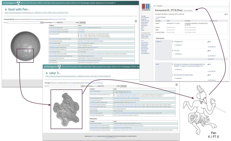
FAIRification and sharing of open data is an important aspect of the German National Research Data Infrastructure (NFDI) and its archaeology related consortium NFDI4Objects. NFDI4Objects offers domain-specific data-driven hubs to publish and share research data, Linked Open Data (LOD), ontologies, community-driven vocabularies and authority files, such as thesauri. This paper demonstrates the content, challenges and possibilities of the Data Hub ‘archaeology.link’. It consists of five thematic parts: 1) Semantic Modelling using the Linked Archaeological Data Ontology (LADO), 2) publication of domain-specific Linked Open Data, 3) community-driven vocabularies such as thesauri, 4) ontologies and 5) research tools.
The ICT revolution in archaeological studies is producing thousands of digital data: interaction can be the key word to make more easy and efficient their access, communication, use, and analysis. It is well known that a lack of standardization is one of the most important limitations that prevent efficient interaction between different data sets. Interoperability and comparability of different archaeological data sets may increase interpretation and analysis. The paper outlines current developments in archaeological data standardization, and looks forward for an easier and more efficient process of integration of different kinds of data. The paper focuses in particular on the possibility of exploiting peer-to-peer and shared technologies to build archaeological data networks in an easy way, disseminating the standardization in a down-to-top way, avoiding technical and practical problems related to the hierarchical imposition of new formats. The paper addresses the possibility to realize and make available on the Internet a free tool to build an archaeological data community, with free access, validation, etc., to share data making the most of free text-based standards: XML, X3D, etc. The overall benefits of the proposed file-sharing solution can be summarized as follows: integration of different data typologies; standardization; interaction and networking; modularity; human readability; cooperative creation of vocabularies, graphical libraries, utilities, tools.
How can we study the making of a medieval juridical space? Which were the agents that affected more? We try to answer to these questions thanks to a postdictive approach. We applied the QGIS algorithms to model the potential political space. We used several agents to get different outcomes. We tried both environmental and human agents to avoid the more deterministic side of this approach. We focused on the plain of Lucca in Northern Tuscany to study the making and development of its bishopric. Then we turned to the southern side of this region to study the district of a castle already excavated and whose territory is known quite well: Selvena. In this last example, we applied a regressive procedure, starting from the 19th century communities boundaries and making hypotheses about the relationship with medieval districts. This procedure can be applied to any context where a certain amount of data is available.
The recording of archaeological data during excavation and their description is a fundamental question for visualization and processing. Typically, this acquisition of data includes conventional 2D drawings, photos, graphic reproductions and videos. Further, we must also consider that for reconstructing the archaeological context (monuments, buildings, stratigraphic layers) it is very important to describe the 3rd dimension. The processing and visualization of 3D information may be considered as a virtual research lab, in which it is possible to recreate all the phases of excavation. In order to obtain these results, we have implemented the Shape from Motion Project, for modelling and 3D reconstruction of digitized and calibrated analogies video data. The project has been undertaken as a scientific partnership between CINECA, CALTECH (California lnstitute of Technology, USA) and AIACE (International Association of Computing in Archaeology
Digital documenting of archaeological evidence represents a crucial tool in the study, preservation, management, and promotion of archaeological sites in remote regions and in fragile landscapes. In fact, in marginal environment, the knowledge related to archaeological heritage can quickly disappear, especially when policies to protect cultural heritage are unreliable or lacking. In the last few decades, archaeological fieldwork has seen the increasing use of Structure-from-Motion (SfM) photogrammetric technique as a tool for mapping and recording archaeological evidence. This technique allows the creation of highly detailed 3D models of archaeological sites, monuments, and artefacts from sets of simple but accurately taken pictures, thus preserving the data for further research or (digital) cultural valorisation. Nowadays, low-cost/commercial off-the-shelf sensors (professional and semi-professional digital cameras and smartphones as well) are widely available and accessible by most of the users operating in cultural heritage documentation. This has made the acquisition of field pictures in archaeological research much more flexible and cost-effective. 3D models obtained from these pictures through photogrammetric commercial software can be scaled with a known-measure providing highly detailed models for archaeological purposes. This enhances the ability of archaeologists to record archaeological features during field surveys and rapidly obtain 3D models. This is especially useful in the case of archaeological surveys carried out in remote and barely accessible areas. In this paper, we present the results of the application of the above-mentioned methods during archaeological surveys in the Sultanate of Oman, where several archaeological features have been recorded through SfM photogrammetry using commercial devices and portable scale-bars. We demonstrate that this is a highly-flexible and fast process to record archaeological heritage in low-accessible or fragile contexts, where a 3D model (with centimetric precision) represents a valuable dataset for further in-lab analysis and cultural dissemination.
Digital documentation and high-quality 3D representation are always more requested in many disciplines and areas due to the large amount of technologies and data available for fast, detailed and quick documentation. This work aims to investigate the area of medium and small sized artefacts and presents a fast and low cost acquisition system that guarantees the creation of 3D models with an high level of detail, making the digitalization of cultural heritage a simply and fast procedure. The 3D models of the artefacts are created with the photogrammetric technique Structure From Motion that makes it possible to obtain, in addition to three-dimensional models, high-definition images for a deepened study and understanding of the artefacts. For the survey of small objects (only few centimetres) it is used a macro lens and the focus stacking, a photographic technique that consists in capturing a stack of images at different focus planes for each camera pose so that is possible to obtain a final image with a higher depth of field. The acquisition with focus stacking technique has been finally validated with an acquisition with laser triangulation scanner Minolta that demonstrates the validity compatible with the allowable error in relation to the expected precision.
Digital documentation and high-quality 3D representation are always more requested in many disciplines and areas due to the large amount of technologies and data available for fast, detailed and quick documentation. This work aims to investigate the area of medium and small sized artefacts and presents a fast and low cost acquisition system that guarantees the creation of 3D models with an high level of detail, making the digitalization of cultural heritage a simply and fast procedure. The 3D models of the artefacts are created with the photogrammetric technique Structure From Motion that makes it possible to obtain, in addition to three-dimensional models, high-definition images for a deepened study and understanding of the artefacts. For the survey of small objects (only few centimetres) it is used a macro lens and the focus stacking, a photographic technique that consists in capturing a stack of images at different focus planes for each camera pose so that is possible to obtain a final image with a higher depth of field. The acquisition with focus stacking technique has been finally validated with an acquisition with laser triangulation scanner Minolta that demonstrates the validity compatible with the allowable error in relation to the expected precision.