

Ground-based photogrammetry at an aerial scale: preliminary results from the 2022 survey at Khirbat al-Mudyana al-‘Aliya, Jordan
- Title
- Ground-based photogrammetry at an aerial scale: preliminary results from the 2022 survey at Khirbat al-Mudyana al-‘Aliya, Jordan
- Creator(s)
- Diederik J.H. HalbertsmaSee all items with this value
- JR PetersonSee all items with this value
- Christopher ScottSee all items with this value
- Rachel StokesSee all items with this value
- Jo-Hannah PlugSee all items with this value
- Bruce E. RoutledgeSee all items with this value
- Laith AlshboulSee all items with this value
- Date
- 2025
- Is Part Of
-
 Archeologia e Calcolatori
- Volume
- 36
- Issue
- 1
- Pages
- 153-170
- Language
- eng
- Abstract
- This paper presents a cost- and time-effective, accessible, and practicable method of 3D site recording at an aerial scale using ground-based photogrammetry. The methodology was deployed in a recent survey of the site of Khirbet al-Mudayna al-‘Aliya, Jordan. The authors used ground-based photogrammetry to capture this 2.3 ha site, generating a com- plete and accurate 3D model and georeferenced orthophoto of the site within several days. The paper demonstrates that ground-based photogrammetry can provide a valid alternative where aerial photogrammetry is impractical. Therefore, this method is useful for baseline recording of site conditions under varying circumstances, with potential uses in site moni- toring and conservation.
- Zotero References Collection
- https://www.zotero.org/groups/5293298/bidiar/collections/VPDGI5ZJ
- Cites
- From Deposit to Point Cloud – a Study of Low-Cost Computer Vision Approaches for the Straightforward Documentation of Archaeological Excavations
- Digital rescue of an archaeological site at risk: the prehistoric village of Portella (Sicily)
- From surfaces to volume: towards a volumetric reconstruction of the archaeological deposit
- Establishing Best Practices for Photogrammetric Recording During Archaeological Fieldwork
- The Digital Revolution to Come: Photogrammetry in Archaeological Practice
-
 Methods and tools for generating the DTM of an archaeological site: the case-study of the photogrammetric survey of Nora (Sardinia, Italy)
- Towards a three-dimensional cost-effective registration of the archaeological heritage
- Massive assumptions and moundbuilders: The history, method, and relevance of architectural energetics
- Theoretical and methodological comments on social complexity and state formation in biblical archaeology
- Labouring with large stones: A study into the investment and impact of construction projects on Mycenaean communities in Late Bronze Age Greece
- Remote sensing and ground survey of archaeological damage and destruction at Nineveh during the ISIS occupation
- Life on the margins: The early Iron Age site of ‘Ayun adh-Dhib, Jordan
- Historical reconstruction and the Mesha’ inscription
- Image-based modelling from Unmanned Aerial Vehicle (UAV) photogrammetry: An effective, low-cost tool for archaeological applications
- The genesis of Moab: A proposal
- Die Moabite. Geschichte und Kultur eines ostjordanisches Volkes im 1. Jahrtausend v. Chr.
- The 2022 survey season at Khirbet al-Mudayna al-‘Aliya, Jordan
- States or Mates? Exploring Collective Action in Iron Age I Jordan
- Exploring Collective Action: An Alternative Approach to Societal Configuration in the Iron Age Southern Levant
- The 2022 survey at Khirbet al-Mudayna al-’Aliya
- Structure from motion: Twenty-first century field recording with 3D technology
- Before the bombs fall: The race to digitise Ukrainian cultural heritage sites
- Why were Moab’s gigantic Iron I fortifications necessary? A new research approach
- Landscape applications of photogrammetry using Unmanned Aerial Vehicles
- The Tel Akko Total Archaeology Project (Akko, Israel): Assessing the suitability of multi-scale 3D field recording in archaeology
- Three-dimensional modelling of large archaeological sites using images obtained from masts: Application to Qubbet el-Hawa Site (Aswan, Egypt)
- Complex communities: The archaeology of early Iron Age West-Central Jordan
- The invention of Ancient Moab
- Extensification in a Mediterranean semi-arid marginal zone: An archaeological case study from early Iron Age Jordan’s eastern Karak plateau
- Seeing through walls: Interpreting Iron Age I architecture at Khirbat al-Mudayna al-‘Aliya
- Thinking globally and analysing locally - South-central Jordan in transition
- Bōz el-Mushelle revisited: Casemates, copper and ‘Early Moab’
- Dating events, not periods: Towards building a new chronology of the Iron Age I
- A Late Iron Age I ceramic assemblage from central Jordan: Integrating form, technology and distribution
- Accurate measurement with photogrammetry at large sites
- The tools of war: Conflict and the destruction of Ukranian cultural heritage
- Providing an archaeological bird’s-eye-view. An overall picture of ground-based means to execute low-altitude aerial photography (LAAP) in archaeology
Linked resources
Export
- Media
-
 Satellite view of KMA (courtesy of Google Earth)
 -
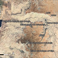 Map of ‘Mudayna’ sites around the Wadi al-Mujib and tributaries (courtesy of D.J.H. Halbertsma)
 -
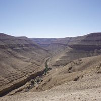 The Wadi an-Nukhayla, a perennial streambed situated below the site (courtesy of D.J.H. Halbertsma)
 -
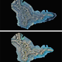
 Plan of KMA with locations of the 37 individual zones (courtesy of D.J.H. Halbertsma)
 -
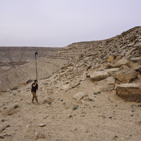 Field-walker walking transect through KMA’s dry-moat (courtesy of D.J.H. Halbertsma)
 -
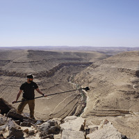 Field-walker applying angled camera method (courtesy of D.J.H. Halbertsma)
 -
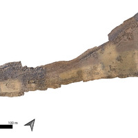 Orthorectified image of the entirety of the site of KMA (courtesy of D.J.H. Halbertsma)
 -
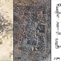 Comparative image demonstrating the level of detail of the 3D model. Left: close up of Building 100 from Google Earth; centre: close up of Building 100 from the 3D model; right: drawing of Building 100 (after Routledge 2000, fig. 10)
 -
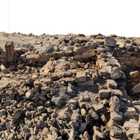 Oblique view of Building 500 looking S, demonstrating added information of recording in 3D: note the preserved stacked stones forming walls, upright pillars, and accurately captured stone rubble (courtesy of D.J.H. Halbertsma)
Position: 687 (52 views)