

Comparative analysis of uav photogrammetry and total station traversing on route survey
- Title
- Comparative analysis of uav photogrammetry and total station traversing on route survey
- Date
- 2019
- Is Part Of
- European Journal of Engineering and Technology
- Volume
- 7
- Issue
- 4
- Pages
- 60 - 72
- Language
- eng
- ISSN
- 2056-5860
- Abstract
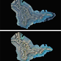
- Currently the Unmanned Aerial Vehicle (UAV) have become an alternative for different engineering applications, especially in surveying. One of these applications is in route surveys, but there are questions about its accuracy and efficiency. The purpose of this research was to evaluate how the UAV photogrammetry technology can compete or replace the traditional ground surveying methods of data acquisition for route survey through data obtained with total station. In order to answer the questions of accuracy, data from the same test location were obtained. A comparison was conducted between the two datasets to evaluate the accuracy of the UAV technique and the classical method, compared to a referenced dataset. This referenced data consisted of twenty-three (23) Ground Control Points (GCPs) established with a dual frequency GNSS receiver, and evenly distributed along the 1.1km route. In other to maintain consistency in both methods of data acquisition, the same GCPs used as markers during image processing, were the ones used for orientation during the total station traversing. Results obtained indicated that with Ground Sample Distance (GSD) of 2.74cm, the UAV technology gave a better elevation result, while the classical method was better in the planimetric aspect. Moreover, other parameters were also considered such as execution time and the area covered along the route. The main problems associated with using a UAV was the level of precision and the visualization of the whole area. The results indicated that the precision was quite satisfactory with a maximum elevation error of 1.9 cm on ground control points.
Linked resources
Export
Position: 670 (56 views)