

The ROV 3D Project: Deep-Sea Underwater Survey Using Photogrammetry: Applications for Underwater Archaeology
- Title
- The ROV 3D Project: Deep-Sea Underwater Survey Using Photogrammetry: Applications for Underwater Archaeology
- Creator(s)
- Drap, Pierre
- Seinturier, Julien
- Hijazi, Bilal
- Merad, Djamal
- Boi, Jean-Marc
- Chemisky, Bertrand
- Seguin, Emmanuelle
- Long, Luc
- Date
- 2015
- Is Part Of
- Journal on Computing and Cultural Heritage
- Volume
- 8
- Issue
- 4
- Pages
- 21:1–21:24
- Language
- eng
- ISSN
- 1556-4673
- Short Title
- The ROV 3D Project
- Abstract
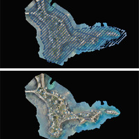
- In this article, we present an approach for a deep-sea survey based on photogrammetry using a remotely operated underwater vehicle (ROV). A hybrid technique gives us real-time results, sufficient for piloting the ROV from the surface vessel and ensuring a uniform coverage of the site, as well as recording high-definition images using an onboard computer that will later provide a survey with millimetric precision. The measurements are made without any contact and are noninvasive. The time required on-site is minimal and corresponds to the time needed by the ROV to cover the zone. With the photos taken at a frame rate synchronized at 10Hz, the ROV required 2 hours to perform the experiment presented in this article: the survey of the Roman shipwreck Cap Bénat 4, at a depth of 328m. The approach presented in this work was developed in the scope of the ROV 3D project. This project, financed by the Fond Unique Interministériel (FUI) for 3 years, brings together two industrial partners and a research laboratory. Companie Maritime d’Expertise (COMEX) coordinated this project.
Linked resources
Export
Position: 5527 (14 views)