

GIS and DTM for the analysis of the archaeological data in Vaste (Southern Apulia)
- Title
- GIS and DTM for the analysis of the archaeological data in Vaste (Southern Apulia)
- Date
- 2020
- Is Part Of
- SCIRES-IT - SCIentific RESearch and Information Technology
- Volume
- 10
- Issue
- 2
- Pages
- 53-64
- Language
- eng
- Rights
- Copyright (c) 2020 Giacomo Vizzino, Giovanni Mastronuzzi
- ISSN
- 2239-4303
- Abstract
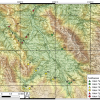
- The use of digital technologies has brought about a remarkable development in the field of archaelogical research. The combined use of tools such as GIS and DTM has guaranteed the possibility of simulating a few aspects of ancient landscapes, contributing to recognise the strategies on which the choice of the sites destined to become settlements in ancient times was based. In the Vaste-Poggiardo area (province of Lecce), systematic research made by the University of Salento has produced an incredibile amount of knowledge on archaelogical evidence dating back to between the Bronze Age and the Middle Ages; on the very basis of this data the experimentation of a spatial analysis in order to reconstruct the ancient landscape has been conducted. The management of the DTM, processed through QGis, has made it possible to use the outcome of spatial analysis to propose a clearer reconstruction of settlements in the Vaste area.
Linked resources
Export
Position: 2886 (18 views)