

Analytical approaches and digital methods in alluvial archaeology: the ‘Ancient Shipyard’ of Pisa-San Rossore as a case study
- Title
- Analytical approaches and digital methods in alluvial archaeology: the ‘Ancient Shipyard’ of Pisa-San Rossore as a case study
- Creator(s)
- Teresa TescioneSee all items with this value
- Date
- 2024
- Is Part Of
-
 Archeologia e Calcolatori
- Volume
- 35
- Issue
- 1
- Pages
- 305–328
- Language
- eng
- Rights
- CC BY-NC-ND 4.0
- Abstract
- This paper aims to present analytical approaches and digital methods for the analysis of ceramic assemblages resulting from catastrophic alluvial flood flows. The study has been developed based on the principles of ‘alluvial archaeology’, a recently-developed field of archaeology. In this research program, ceramic records have been treated on a par with clasts in the geomorphological analyses of alluvial sediments. To test the different analytical procedures the ‘Ancient Shipyard’ of Pisa-San Rossore has been selected as a case study. This archaeological site represents a river channel, affected by several alluvial flood events. The analysis achieved several objectives, including the definition of the formation processes of the deposition (in synergy with the results of geomorphological data), the chronological framework of alluvial floods, the dynamics of flows, and locating the original deposition of the ceramic assemblage. In this regard, the combination of different approaches has proven particularly useful, ranging from computational analyses for chrono-typological determination of ceramic assemblages to intra-site spatial analyses, which have been useful in defining alluvial flood flows and the subsequent movement of ceramic assemblages.
- Zotero References Collection
- https://www.zotero.org/groups/5293298/bidiar/collections/NVAJUC77
- Cites
- Le navi antiche di Pisa. Guida archeologica
- Gaussian Curves for Visualizing Chronological Patterns of Ceramic Finds and Residuality
- Exploratory Network Reconstruction with Sparse Archaeological Data and XTENT
- Banche dati, GIS e Web GIS: breve storia delle tecnologie applicate ai beni archeologici nel Laboratorio di Informatica per l’Archeologia dell’Università del Salento.
- Late-Holocene catastrophic floods in the terminal Arno River (Pisa, Central Italy) from the story of a Roman riverine harbour
- A simple algorithm for the mapping of TIN data onto a static grid: Applied to the stratigraphic simulation of river meander deposits
- Registro para la cuantificación de cerámica arqueológica: estado de la cuestión y una nueva propuesta. Protocolo de Sevilla (PRCS/14)
- Reconstructing prehistoric settlement models and land use patterns on Mt. Damota/SW Ethiopia
- Fast topological construction of delaunay triangulations and voronoi diagrams
- L’archeologia delle alluvioni: problemi di analisi dei contesti ceramici. Un caso di studio dal Cantiere delle Navi Antiche di Pisa-San Rossore
- I residui nella stratificazione urbana. Metodi di quantificazione e implicazioni per l'interpretazione delle sequenze : un caso di studio dalle pendici settentrionali del Palatino
- ‘Accedere’ allo scavo archeologico. Sistemi (e problemi) di elaborazione dei dati
- ll cantiere delle navi antiche di Pisa San Rossore: importazioni ed esportazioni nel commercio del Mediterraneo. Il contesto di eta repubblicana
- Méthodes de quantification du mobilier céramique: Etat de la question et pistes de réflexion
- Pottery in Archaeology
- The evolution of an agrarian landscape. Methodological proposals for the archaeological study of the alluvial plain of Medellin (Guadiana basin, Spain)
- How Many Pots Make Five?—An Historical Review of Pottery Quantification
- Datazione assoluta di alcuni relitti dal contesto delle navi di Pisa. Risultati preliminari delle indagini dendrocronologiche e radiometriche col 14C
- La ceramica nello scavo archeologico: analisi, quantificazione e interpretazione
- De la formalisation du traitement des données stratigraphiques en archéologie de terrain
- Triangulated Irregular Network (TIN) models
- GIS and Archaeological Site Location Modeling
- Pottery as proxy of diet change in Late Antique Campania
- Velia. Fenomeni alluvionali e trasformazioni dell’abitato
- Remote sensing in archaeology. 11º Ciclo di lezioni sulla ricerca applicata in archeologia (Certosa di Pontignano, 6-11 dicembre 1999)
- Stratigrafia fluviale, portuale e terresre: la sequenza dello scavo delle navi di Pisa, S : Rossore.
- Alkedo. Navi e commerci della Pisa romana
- Ambiente rinvenimenti e sequenza. Un breve riassunto aggiornato sullo scavo delle navi
- People, climate and alluviation: theory, research design and new sedimentological and stratigraphic data from Etruria
- Alluvial Geoarchaeology: Floodplain Archaeology and Environmental Change
- La quantification des céramiques: conditions et protocole : actes de la table ronde du Centre archéologique européen du Mont-Beuvray, Glux-en-Glenne, 7-9 avril 1998 ; sous la direction de Patrice Arcelin et Marie Tuffreau-Libre
- Il bagaglio di un marinaio (le navi Romane di Pisa)
- Pollen analysis of the ship site of Pisa San Rossore, Tuscany, Italy: The implications for catastrophic hydrological events and climatic change during the late Holocene
- Using 3D models to analyse stratigraphic and sedimentological contexts in archaeo-palaeo-anthropological pleistocene sites (Gran Dolina Site, Sierra De Atapuerca)
- Dismounting, conserving, displaying ships. The MNAP-Museo delle Navi Antiche di Pisa and the activity of Centro di Restauro del Legno Bagnato di Pisa
Linked resources
Export
- Media
-
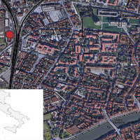 Placement of the case study
 -
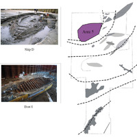 Area 5 positioning (re-elab. after Camilli et al. 2005, fig. 2): Ship D and Boat I at the time of the discovery (©Museo delle Navi Antiche di Pisa)
 -
 Workflow of the analytical approaches (elab. by T. Tescione)
 -
 Chronological quantifications: sum of the weighted averages, cumulative diagram, analysis of residuality (elab. by P. Rosati, T. Tescione).
 -
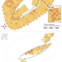
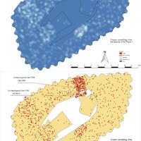 Dispersal area of ceramic assemblage (based on the MNI) from the deposits of Phase 2: heatmap and point spatial analysis map (elab. by P. Rosati, T. Tescione)
 -
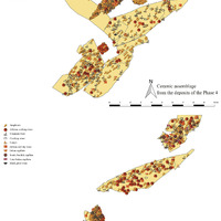 Map with ceramic distributions based on membership classes (Phase 4 and 5) (elab. by P. Rosati, T. Tescione)
 -
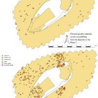 Map with ceramic distributions based on chronologically coherent and residual material (Phase 2) (elab. by P. Rosati, T. Tescione)
 -
 Map with ceramic distributions based on the completeness index (Phase 2 and 5) (elab. by P. Rosati, T. Tescione)
 -
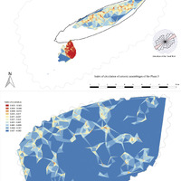 Map with ceramic distributions represented according to Triangulated Irregular Networks (TIN) (Phase 5 and 3rd century AD ceramic assemblage) (elab. by P. Rosati, T. Tescione)
 -
 Map with ceramic distributions represented according to Triangulated Irregular Networks (TIN) (Phase 2 and 5th century AD ceramic assemblage) (elab. by P. Rosati, T. Tescione)
Position: 686 (37 views)