

Methods and tools for generating the DTM of an archaeological site: the case-study of the photogrammetric survey of Nora (Sardinia, Italy)
- Title
- Methods and tools for generating the DTM of an archaeological site: the case-study of the photogrammetric survey of Nora (Sardinia, Italy)
- Creator(s)
- Giulio Alberto Da VillaSee all items with this value
- Arturo ZaraSee all items with this value
- Emanuela FaresinSee all items with this value
- Jacopo BonettoSee all items with this value
- Cristiano MieleSee all items with this value
- Antonio PersichettiSee all items with this value
- Date
- 2024
- Is Part Of
-
 Archeologia e Calcolatori
- Volume
- 35
- Issue
- 1
- Pages
- 369–388
- Language
- eng
- Rights
- CC BY-NC-ND 4.0
- Abstract
- This paper describes the high-resolution survey of the archaeological site of Nora (Sardinia, Italy) using the aerophotogrammetric technique. The survey was conducted in October 2021 on a 14-hectare peninsula located in the Gulf of Cagliari. Previous attempts to survey the area, aside from the 1 metre/pixel LiDAR survey carried out by the Region of Sardinia, have been hampered by the challenges posed by the size of the area and the costs involved. The Digital Terrain Model was obtained from the 3D model created with the Agisoft Metashape© software by removing the buildings and the vegetation. The segmentation process was carried out using Cloud Compare and the resulting DTM was then analysed using the geomorphological analysis tools provided by QGIS. The seabed DTM was obtained through several survey campaigns between 2013 and 2015, using the same software. The terrestrial DTM was merged with the seabed DTM, resulting in a comprehensive 3D and 2D model of the peninsula and its surroundings. The final DTM was printed with rapid prototyping technologies to explore its potential use as a tactile model for promotion and dissemination in the field.
- Zotero References Collection
- https://www.zotero.org/groups/5293298/bidiar/collections/G4HBIUIE
- Cites
- Airborne and spaceborne remote sensing for archaeological and cultural heritage applications: A review of the century (1907–2017)
- UAV-based photogrammetry: Assessing the application potential and effectiveness for archaeological monitoring and surveying in the research on the ‘valley of the kings’ (Tuva, Russia)
- More Than a Flight: The Extensive Contributions of UAV Flights to Archaeological Research – The Case Study of Curium Site in Cyprus
- Seasonal dune and beach monitoring using photogrammetry from UAV surveys to apply in the ICZM on the Ravenna coast (Emilia-Romagna, Italy)
- Uav photogrammetry for mapping and 3d modeling – current status and future perspectives
- UAV Photogrammetry and GIS Interpretations of Extended Archaeological Contexts: The Case of Tacuil in the Calchaquí Area (Argentina)
- Geodetic Methods for Documenting and Modelling Cultural Heritage Objects
- Photogrammetry as a New Scientific Tool in Archaeology: Worldwide Research Trends
- UAV vs classical aerial photogrammetry for archaeological studies
- 3-D reconstruction of an abandoned montane reservoir using UAV photogrammetry, aerial LiDAR and field survey
- Comparative analysis of digital photogrammetry software for cultural heritage
- Investigations into the accuracy of the uav system dji matrice 300 Rtk with the sensors zenmuse p1 and l1 in the hamburg test field
- Digital 3D modeling using photogrammetry and 3D printing applied to the restoration of a Hispano-Roman architectural ornament
- Digitization of Ancient Artefacts and Fabrication of Sustainable 3D-Printed Replicas for Intended Use by Visitors with Disabilities: The Case of Piraeus Archaeological Museum
- Examples and Results of Aerial Photogrammetry in Archeology with UAV: Geometric Documentation, High Resolution Multispectral Analysis, Models and 3D Printing
- The ROV 3D Project: Deep-Sea Underwater Survey Using Photogrammetry: Applications for Underwater Archaeology
- The Potential of Unmanned Aerial Vehicle for Large Scale Mapping of Coastal Area
- Sistema cartografico per il centro antico di Nora
- 3D modelling in the agora of Segesta: Techniques and data interpretation
- Using unmanned aerial vehicle photogrammetry for digital geological surveys: case study of Selmun promontory, northern of Malta
- Nora nei secoli dell’alto Medioevo
- Monitoring the erosion and accretion of a human-built living shoreline with drone technology
- The methodology of documenting cultural heritage sites using photogrammetry, UAV, and 3D printing techniques: the case study of Asinou Church in Cyprus
- Salt pans as a new archaeological sea-level proxy: A test case from Dalmatia, Croatia
- Un deposito rituale di antoniniani dal settore orientale dall’abitato di Nora (Sardegna)
- Use of 3D models as a didactic resource in archaeology. A case study analysis
- Three-Dimensional Digitization of Archaeological Sites—The Use Case of the Palace of Knossos
- Drone Application in Topography Services - Case Study
- Nora. Scavi eseguiti nel perimetro di quell’antica citta e in una delle sue necropoli durante i mesi di maggio e giugno 1901
- Landscape applications of photogrammetry using unmanned aerial vehicles
- 3d printing for dissemination of maya architectural heritage: the acropolis of la blanca (guatemala)
- Nora. Viaggiatori, antichisti e archeologi. Storia delle ricerche e degli studi tra XVI e XX secolo
- GIS-based mapping of archaeological sites with low-altitude aerial photography and structure from Motion: A case study from Southern Jordan
- Use of various surveying technologies to 3d digital mapping and modelling of cultural heritage structures for maintenance and restoration purposes: the tholos in delphi, greece
- Photogrammetric mapping using unmanned aerial vehicle
- Comparative analysis of uav photogrammetry and total station traversing on route survey
- Drone-Based Imaging in Archaeology: Current Applications and Future Prospects
- Drones as tools for monitoring beach topography changes in the Ligurian Sea (NW Mediterranean)
- Progetto “Nora e il mare” 2.0: un nuovo approccio multidisciplinare per la ricostruzione dell’ambiente antico
- Nora e il mare. Il Progetto Noramar. Attività 2011
- Nora fenicia. Nuovi dati e nuove letture
- Implementation of ultra-light UAV systems for cultural heritage documentation
- Variazioni del livello marino in Sardegna durante gli ultimi millenni sulla base di indicatori geo-archeologici costieri
- Large scale topographic mapping based on unmanned aerial vehicle and aerial photogrammetric technique
- Appendice tecnica. La creazione di un modello tridimensionale del terreno per il sito di Nora
- Nora. Guida agli scavi
- Applying digital tools as an effective support for conservation research and design process: the Rocca Janula castle in Cassino, Lazio
- Documentation of cultural heritage by photogrammetric methods: a case study of Aba's Monumental Tomb
- Nora 1990-2020. Bibliografia generale
- Sound Methods: The Necessity of High-resolution Geophysical Data for Planning Deepwater Archaeological Projects
- UAV photogrammetry for archaeological site survey. 3D models at the Hierapolis in Phrygia (Turkey)
- Le variazioni del livello del mare e l'articolazione dell'abitato di Nora (Sardegna, Italia) tra età nuragica e tarda età romana
- Importance of unmanned aerial vehicles (uavs) in the documentation of cultural heritage
- Nora nel V secolo: dall'emporio fenicio alla colonia cartaginese
- Drones in Archaeology. State-of-the-art and Future Perspectives
Linked resources
Export
- Media
-
 The orthophoto showing the positions of all GCPs (a) and all acquired photos (b)
 -
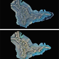
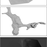
 Processing workflow; from top to bottom: azimuthal view of the area; side view of the cloud before segmentation; azimuthal view of the point cloud after segmentation and side view of the cloud after segmentation
 -
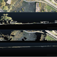
 The cloud resulting from the non-ground point deleting activity; a considerable part of the cloud has been removed
 -
 Example of the workflow: 1) the mesh with roughness due to the vegetation covering the Marina Militare area; 2) the area after a first attempt with value 10; 3) the area after a second attempt with value 50
 -
 The three steps to obtain the complete DTM: at the top, the DTM of the seabed from which the landmass has been removed; in the middle, the model of the peninsula to be integrated into the seabed reel; at the bottom, the complete model
 -
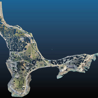
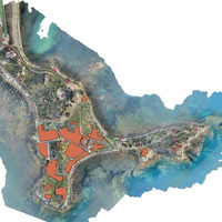 Orthophoto of the site with overlaid vector elements (excavation areas and Regional Trigonometric Vertices) of the Regional Technical Map (CTR) of Sardinia (reference system EPSG 3003)
 -
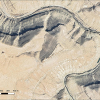
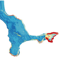 The slope map of the peninsula shows the main changes in slope at the erosion fronts. The overburden of the so-called Kasbah is in the centre of the peninsula and is highlighted in red
 -
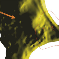 Detail of the peninsula. Yellow areas are protected from the Mistral wind as they face in the opposite direction (S-E); red areas indicate evidence from the Phoenician period and the hypothesis of the settlement’s extension
 -
 False-colour DTM of the Phoenician peninsula with yellow areas indicating submerged land.
 -
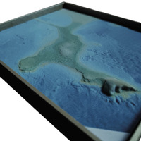 The 3D printed tile displays clear levels and colours
Position: 879 (36 views)