

Application of integrated 3D survey technologies in an Etruscan necropolis: the case of Sasso Pinzuto (Tuscania, VT)
- Title
- Application of integrated 3D survey technologies in an Etruscan necropolis: the case of Sasso Pinzuto (Tuscania, VT)
- Creator(s)
- Alessandro NasoSee all items with this value
- Rodolfo BrancatoSee all items with this value
- Martina ZinniSee all items with this value
- Simone AmiciSee all items with this value
- Date
- 2024
- Is Part Of
-
 Archeologia e Calcolatori
- Volume
- 35
- Issue
- 1
- Pages
- 389–406
- Language
- eng
- Rights
- CC BY-NC-ND 4.0
- Abstract
- The aim of this paper is to present the results of the research undertaken through a series of on-site surveys (2021-2023) at the Sasso Pinzuto site, located approximately 1 km SE of Tuscania (Viterbo, Italy). Situated along the eastern side of the Marta river valley, the necropolis layout is little known but it is extensive, including ca. 100 rock-cut chamber tombs. The 2021-22 archaeological campaigns started with a new topographical survey of the site and investigated two areas conventionally defined the Northern and the Southern Area. In the Northern Area, specifically within the vicinity of Tumulus 1, fragments of mould-decorated architectural plaques from a building discovered. In the Southern Area, a small plateau about 90 m from the Northern Area, four burial graves (n. 126, 127, 128, 130) and two chamber tombs (125 and 129) were excavated. This study sheds light to the great potential of applying digital technologies for a new understanding of the Etruscan tombs. Indeed, by using various non-destructive prospecting methods (aerial photogrammetry, fieldwalking survey, architectural drawings), coupled with precise location using RTK GNSS, and integration of legacy data in GIS, the site underwent a comprehensive reexamination.
- Zotero References Collection
- https://www.zotero.org/groups/5293298/bidiar/collections/4SNP4DPN
- Cites
- Laser Scanner 3D per lo studio e la catalogazione dell'archeologia medievale: la chiesa di Santa Croce in Bergamo
- Digital technologies and the archaeological topography of Castellito (Sicily): the reconstruction of a Roman villa
- Using Computers in Archaeology Towards Virtual Pasts
- Symbols of Wealth and Power: Architectural Terracotta Decoration in Etruria and Central Italy, 640-510 B. C.
- Frühetruskische Grab- und Hausarchitektur
- Testimonianze di Tuscania,
- Gli ipogei della necropoli etrusca di Casale Galeotti (Tuscania): tipologie architettoniche e trasformazioni
- La necropoli etrusca di Casale Galeotti a Tuscania: studio storico-topografico
- Tuscana. Forma Italiae VII.2
- Per una tipologia delle tombe di Tuscania
- The “Shape of Monuments” project: traditional methods and new technologies in the Basilica of San Lorenzo Fuori le Mura, Rome
- Tombe a camera con atrio e tre celle: novità da Tuscania,
- Archeologia e musealizzazione virtuale
- Una tomba infantile della necropoli di Sasso Pizzuto di Tuscania in Mediterranea XV
- Le terrecotte architettoniche di Tuscania
- Le Fibule dell'Italia Meridionale e della Sicilia dall'eta del Bronzo Recente al VI secola a C.
- Beziehungen der ägyptischen Kultur zu Altitalien. 2 volumes
- Egypt and Egyptianizing Scarabs: A Typology of Steatite, Faience and Paste Scarabs from Punic and other Mediterranean Sites: No. 44
- Archaeological LiDAR in Italy: enhancing research with publicly accessible data
- Italy’s Hidden Hillforts: A Large-Scale Lidar-Based Mapping of Samnium
- Fieldnotes for the development and publication of open standards for the vectorisation of archaeologic and architectonic topographic legacy data
- Computer Vision e Structure From Motion, nuove metodologie per la documentazione archeologica tridimensionale: un approccio aperto.
- La necropoli di Sasso Pinzuto a Tuscania: campagna di scavo 2022
- 3D Modelling and Visualization in Field Archaeology. From Survey To Interpretation Of The Past Using Digital Technologies
- Il nuovo piano straordinario di telerilevamento ambientale: esempio di sinergia tra amministrazione centrale e amministrazione locale
- Osservazioni archeo-topografiche sull’insediamento d’altura nel territorio ibleo (Sicilia sud-orientale): il caso di Monte Casasia
Linked resources
Export
- Media
-
 The Sasso Pinzuto area (in white) in the context of Tuscania (Viterbo, Latium) on a satellite image (2023, Google Maps)
 -
 Aerial views A) on the archaeological site of Sasso Pinzuto with Tuscania in the background; B) on the Area B investigated in 2022 campaign
 -
 Sasso Pinzuto-Tuscania (in white): in the context of the river Marta Valley on a historical aerial photograph georeferenced in GIS; in white dash dot line, A) the Northern Area; B) the Southern Area
 -
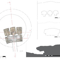 Tumulus 1, Sasso Pinzuto-Tuscania: tomb plan and sections with the chambers’ orthophotoplan. The crepis of the tumulus is not entirely excavated
 -
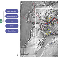 A) Diagram of the topographic data integration process; B) Sasso Pinzuto-Tuscania (in white): archaeological legacy data available for the site pletted on a topographic basis obtained from a 1 m LiDAR Composite DTM (2013, Ministero dell’Ambiente e della Tutela del territorio e del mare) in the GIS created for the project
 -
 Sasso Pinzuto-Tuscania: workflow followed for SfM modelling: A) on-site photo capturing inside Tumulus 1, a snapshot of Agisoft Metashape software, showing the position of the images, photo alignment, and camera settings, the location of GCPs; B) UAS-Based Photogrammetry, photo alignment the Agisoft Metashape project, the dense point cloud and the DTM finally obtained (right)
 -
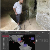 Tumulus 1, Sasso Pinzuto-Tuscania: A) setup 2 scanned with the BLK360G1; B) georeferencing by Gruppo Nuvola with GNSS and TPS measurements.
 -
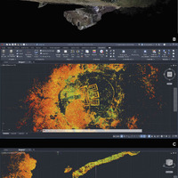 Tumulus 1, Sasso Pinzuto-Tuscania: A) Group Point Cloud deduced from static and mobile LS union; B) cloud data that can be vectorized within CAD software; C) section with height dimensioning between the walking surface of the central chamber and the external surface.
 -
 Tumulus 1, Sasso Pinzuto-Tuscania: A) registration process between two cloud setups; B) 3D modeling separately from the cloud data; C) point cloud dimensioning at 1:1 scale
 -
 Tumulus 1, Sasso Pinzuto-Tuscania: A) spherical RGB image measurable with Point Cloud; B) equirectangular image extracted from the scanner for documentation purposes; C) point cloud group sectioned at the height of the funeral beds
Position: 692 (51 views)