

From the river to the sea of the setting sun: route networks between the Euphrates and the Mediterranean during the Iron Age (1200-600 BCE)
- Title
- From the river to the sea of the setting sun: route networks between the Euphrates and the Mediterranean during the Iron Age (1200-600 BCE)
- Date
- 2024
- Is Part Of
-
 Archeologia e Calcolatori
- Volume
- 35
- Issue
- 1
- Pages
- 251–268
- Language
- eng
- Rights
- CC BY-NC-ND 4.0
- Abstract
- The study of ancient roads has been important in understanding political, social, and cultural transformations of ancient trade networks and economies. In the Near East, landscape-oriented research has immensely contributed to the analysis of pre-modern road systems. However, while for Roman and medieval periods this method produced a dataset that implemented the rich corpus of historical information, research on pre-Roman connectivity networks strongly relies on the archaeological record, mostly represented by data from surveys. The use of these data allows a long term and chronologically unprecise reconstruction of ancient itineraries. Therefore, gaps in the data are often filled by the transposition of later itineraries, risking reiterating the idea that road networks are static, stable over a very long period. This article aims to contextualise connecting networks and route landscapes from the Euphrates river to the Mediterranean sea during the Iron Age (1200-600 BCE). The study will make use of an integrated approach by using multiple datasets. The research will argue that by considering different data, it is possible to offer a critical interpretation of the main route network employed during the Iron Age to connect the Euphrates area with the sea.
- Zotero References Collection
- https://www.zotero.org/groups/5293298/bidiar/collections/23JLIF3Z
- Cites
- Ibn Hani. Rapport préliminaire sur la quatrième campagne de fouilles (1978) à Ibn Hani (Syrie)
- Political Geography and Palatial Crete
- Der Tempel von Ain Dara
- The Iron Age of the Middle Euphrates in Syria and Turkey
- Tying the Threads of Eurasia: Trans-regional Routes and Material Flows in Transcaucasia, eastern Anatolia and western Central Asia, c.3000-1500BC
- Greek and related pottery from Al Mina. A case study of production, consumption and distribution of Greek pottery in the Eastern Mediterranean from the 9th to the end of the 7th century BC.
- Viaggio nella Siria centrale e in mesopotamia
- Per Cappadociae partem... iter feci. Graeco-Roman Routes between Taurus and Halys
- Villages antiques de la Syrie du nord. Le massif du Bélus à l'époque romaine,
- The CIERA program and activities: Focus on the roads and wayside caravanserais in Medieval Syria
- Tell Gindaris and the western Afrin valley,
- The Iron Age Settlement at 'Ain Dara, Syria: Survey and Soundings: 786
- Reconstructing historical journeys with least-cost analysis: Colonel William Leake in the Mani Peninsula, Greece
- The site of Al-Mina, the port of Aḫtâ and Mediterranean trade in the age of the Assyrian Empire.
- Excavation and Survey in the Jabbul Plain, Western Syria: The Umm el-Marra Project 1996–1997
- Excavations in the Plain of Antioch III: Stratigraphy, Pottery, and Small Finds from Chatal Hoyuk in the Amuq Plain: Stratigraphy, Pottery, and Small finds
- A Description of the East, and Some Other Countries.
- Palestine And Syria; Handbook For Travellers
- Sabuniye: A Late Bronze-Iron age port settlement on the northeastern Mediterranean coast
- The Geography of Trade: Landscapes of Competition and Long-distance Contacts in Mesopotamia and Anatolia in the Old Assyrian Colony Period
- Urban Built Environments in Early 1st Millennium Syro-Anatolia: Results of the Tayinat Archaeological Project, 2004–2016
- Interregional Interaction in the Eastern Mediterranean during the Iron Age
- The Syro-Anatolian City-States: An Iron Age Culture
- The Syrian Jezireh in the Late Assyrian period: a view from the countryside
- The Campaigns of Sargon II, King of Assyria, 721-705 B.C.: 55
- The River Qoueiq, Northern Syria, and its Catchment, Part ii: Studies arising from the Tell Rifa'at Survey 1977-79
- Karkemish. An ancient capital on the Euphrates
- Foreign influences and local tradition in the Iron Age pottery production from Arslantepe. Evidence from the new excavations of the Neo-Hittite levels
- Fluttuazioni territoriali e caratteristiche tipologiche degli insediamenti nella regione del Matah (Siria). Nota preliminare
- Ancient Records of Assyria and Babylonia Volume 2: Historical Records of Assyria From Sargon to the End
- Aram and Israel: or, The Aramaeans in Syria and Mesopotamia
- The temple of the storm god in aleppo during the late bronze and early iron ages
- Archaeology in Syria
- Some New Assyrian Rock-Reliefs in Turkey
- Preliminary Report on the Excavations at Tell Rifa‘at
- The settlement of Yauna, ‘Ionian’ identity and the Greek presence on the Syrian coast in the second half of the eighth century BC: a reassessment of two letters from the Nimrud correspondence
- On the Shifting Border Between Mesopotamia and the West: Seven Seasons of Joint Turkish-German Excavations at Oylum Höyük
- An Archaeological Survey of the Plain of Jabbul, 1939
- The ways of an empire: Continuity and change of route landscapes across the Taurus during the Hittite Period (ca. 1650–1200 BCE)
- Bridging Digital Approaches and Legacy in Archaeology
- The Neo-Assyrian Provincial Administration at Tayinat (Ancient Kunalia)
- Eastern Mediterranean Economic Exchange during the Iron Age: Portable X-Ray Fluorescence and Neutron Activation Analysis of Cypriot-Style Pottery in the Amuq Valley, Turkey
- Stone Worlds: Technologies of Rock Carving and Place-Making in Anatolian Landscapes
- Viaggio nella Siria Centrale e nella Mesopotamia. Lettere famigliari
- The 2007 season of excavations at Tell Qarqur
- The roads from and to Aleppo: Some historical-geographical considerations in light of new archaeological data
- Assyrian warfare
- The Roman Frontier With Persia in North-Eastern Mesopotamia: Fortresses and Roads Around Singara
- Roads on the frontier between Rome and Persia
- Tell Ahmar on the Syrian Euphrates: From Chalcolithic Village to Assyrian Provincial Capital
- Kārus on the Frontiers of the Neo-Assyrian Empire
- The Iron age graves of Carchemish
- The Construction of the Assyrian Empire: A Historical Study of the Inscriptions of Shalmaneser III (859-824 B.C.) Relating to His Campaigns to the West
- On Art in the Ancient Near East: Of the First Millennium B.C.E.
- The Making of the Middle Sea: A History of the Mediterranean from the Beginning to the Emergence of the Classical World
- Studies on the annals of Ashurnasirpal II: Topographical analysis
- Mesopotamia. Asia citerior. Auctore Henrico Kiepert Berolinensi. Geographische Verlagshandlung Dietrich Reimer (Ernst Vohsen) Berlin, Wilhemlstr. 29. (1903)
- Ancient Antioch: From the Seleucid Era to the Islamic Conquest
- The Ancient Piedmont Route of Northern Mesopotamia
- Palestine And Syria; Handbook For Travellers
- Mounds in the Plains of Antioch: An Archaeological Survey
- Tell Shiukh Fawqani. 1994-1998
Linked resources
Export
- Media
-
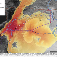
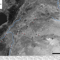 General map of the target area
 -
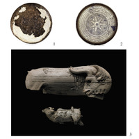 Metal and ivory objects found at Nimrud (© The Trustees of the British Museum)
 -
 Cypriot pottery found at 1) Tell Tayinat (after Karacic, Osborne 2017); 2) Chatal Hoyuk (after Pucci 2019); 3) Tell Ahmar (after Bunnens 2022); 4) Arslantepe (after Manuelli 2010).
 -
 1) Euboean pottery found at Tell Tayinat (after Osborne et al. 2019); 2) Chatal Hoyuk (after Pucci 2019); 3) Al Mina (after Vacek 2012)
 -
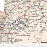 Map drawn by Kiepert (1903) with Roman, medieval and modern roads and LCPs results
 -
 LCP and LCC analysis of the Syrian coast and the Orontes Delta
 -
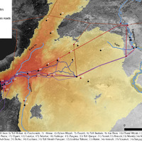
 LCP and LCC analysis of the Mediterranean and the Euphrates
 -
 LCP and LCC analysis the routes between Aleppo and the Mediterranean
Position: 1064 (26 views)