

Le cave antiche di Porto Miggiano (Santa Cesarea, Lecce): analisi metrologica e rilievo topografico dei settori estrattivi
- Title
- Le cave antiche di Porto Miggiano (Santa Cesarea, Lecce): analisi metrologica e rilievo topografico dei settori estrattivi
- Date
- 2023
- Is Part Of
-
 Archeologia e Calcolatori
- Volume
- 34
- Issue
- 2
- Pages
- 163–184
- Language
- ita
- Rights
- CC BY-NC-ND 4.0
- Abstract
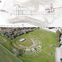
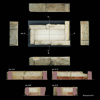
- The ISPC-CNR is conducting research activities aimed at identifying ancient quarries that supplied the public building sites in the Athenaion of Castro, where excavations revealed dry-stone city walls made of calcarenite blocks and built in three phases between the 4th and 2nd cent. BC. The paper is focused on the large coastal quarries of Porto Miggiano, located approximately 4.5 km NE of Castro, where the extraction was carried out in function of sea transportation of the blocks. The extraction sites were documented through laser scanning and photogrammetry by a drone. In the main quarry, which covers an area of approximately 0.4 hectares, thanks to the metrological analysis of the stepped faces, four extraction areas were identified corresponding to at least five cultivation phases. The oldest and most extensive one affects the central sector of the quarry, where large blocks compatible (for dimension and macroscopic aspect) with those of the third phase of the Castro city walls, dated to the beginning of the 2nd cent. BC, were extracted.
- Cites
- 3D technologies for a critical reading and philological presentation of ancient contexts
- Reconstruction of Villino Florio’s wooden ceiling using 3D technologies
- Knowledge, Analysis and Innovative Methods for the Study and the Dissemination of Ancient Urban Areas
- Stratigrafia del neogene e quaternario del salento sud-orientale (con rilevamento geologico alla scala 1:25.000)
- Un exemple de prospection systématique au sol: histoire de la ville de Vaste et de son territoire (prov. de Lecce)
- The harbour of the mansio ad speluncas (Brindisi, Italy): A key to sea level changes in the past 3500 years?
- Middle to Late Holocene relative sea-level changes recorded on the coast of Apulia (Italy) / Variations relatives du niveau marin pendant l'Holocène moyen et supérieur le long des côtes méridionales des Pouilles (Italie)
- I siti archeologici costieri pugliesi come markers delle variazioni del livello del mare
- Salentum a salo. 1: Porti, approdi, merci e scambi lungo la costa adriatica del Salento
- Geomonumental routes: the granitic bridges over the Guadarrama river (Madrid, Spain) and the calcarenitic coastal towers from the Salento (Italy)
- Evidence of relative sea level rise along the coasts of central Apulia (Italy) during the late Holocene via maritime archaeological indicators
- Abandoned Quarries and Geotourism: an Opportunity for the Salento Quarry District (Apulia, Southern Italy)
- Millstone coastal quarries of the Mediterranean: A new class of sea level indicator
- New Data on the Messapian Necropolis of Monte D’Elia in Alezio (Apulia, Italy) from Topographical and Geophysical Surveys
- I fregi a girali abitati dell'Athenaion di Castro: Iconografia e linguaggio formale di una creazione tarentina
- Σμειριδες: Depositi portuali, marmi di cava e navi
- Hand Made 3d Modelling for the Reconstructive Study of Temple C in Selinunte: Preliminary Results.
- Integrated Geoscientific Surveys at the Church of Santa Maria della Lizza (Alezio, Italy)
- L'Athenaion di Castro in Messapia
- Castro. Lo scavo di località “Muraglie”: nuovi dati sul circuito murario di età messapica,
- Produzioni antiche sulla costa sud-orientale della Sicilia: saggi di topografia antica litoranea
- Caratteristiche geo-meccaniche e problemi di instabilità della falesia di Porto Miggiano (Puglia)
- Le antiche cave nei depositi calcarenitici lungo la costa pugliese: un esempio di geoarcheositi da tutelare e valorizzare
- Rilievo e restituzione grafica delle aree delle Pozzelle di Pirro e di Apigliano
- New reconstructive proposal for a critical reading of the archaeological documentation of Syracuse in Greek times
- Dalla latomia al cantiere. Il trasporto nautico della pietra,
- Castro. 2, Castello, torre Est
- Castro. 3, Piazza Perotti
- Attività dell’Unità operativa Topografia antica
- Le transports dans l’antiquité
- Castro. Rinvenimento di mura preromane
- Note illustrative della Carta Geologica d’Italia alla scala 1:100.000, Foglio 223, Capo S. Maria di Leuca
- Castro. 1, Capanne
- Nora. Le cave di pietra della città antica
- Caratteristiche minero-petrografiche e geo-chimiche di calcareniti da cave costiere della penisola salentina: contributo allo studio dello sfruttamento nell’antichità,
- Identification of an ancient limestone quarry on the ionian coast ofsouthern apulia (southern italy): rock characterization and new data about its exploitation over time
- Note illustrative della Carta Geologica d’Italia alla scala 1:50.000, Foglio 537, Capo Santa Maria di Leuca
- L’archeologia del paesaggio costiero e la ricostruzione delle trasformazioni ambientali: gli insediamenti di Torre Santa Sabina e Torre Guaceto (Carovigno, Br)
- Costruire il Santuario: lo sfruttamento delle cave di calcarenite
- L’Athenaion di Castro
- Note illustrative della Carta Geologica d’Italia alla scala 1:100.000, Foglio 214
Linked resources
Export
Position: 4616 (15 views)