

Dealing with doubts: site georeferencing in archaeology and in the geosciences
- Title
- Dealing with doubts: site georeferencing in archaeology and in the geosciences
- Creator(s)
- Florian ThierySee all items with this value
- Fiona SchenkSee all items with this value
- Stefanie BaarsSee all items with this value
- Date
- 2024
- Is Part Of
-
 Archeologia e Calcolatori
- Volume
- 35
- Issue
- 2
- Pages
- 97-106
- Language
- eng
- Rights
- CC BY-NC-ND 4.0
- Abstract
- Archaeological research must handle issues such as vagueness and uncertainty in data modelling. Especially vagueness and uncertainty must be modelled to work with geodata. However, for linking data and FAIRification graph-based modelling as Linked Open Data (LOD) proposed by Berners-Lee is the method and technique of choice. This paper discusses three data-driven interdisciplinary use cases of dealing with and modelling vague and uncertain geo-references (here especially findspots) based on literature as LOD from the archaeological and geosciences domain (Irish Ogham Stones, Campanian Ignimbrite, and Silver Coinage of Croton), implementing three modelling strategies using Wikidata, Linked Open Data and Wikibase.
- Zotero References Collection
- https://www.zotero.org/groups/5293298/bidiar/collections/MG2VWTHA
- Cites
- The FAIR Guiding Principles for scientific data management and stewardship
- SPARQLing Ogham Stones: New Options for Analyzing Analog Editions by Digitization in Wikidata
- Nationale Forschungsdateninfrastruktur (NFDI)
- NFDI4Objects - Proposal
- Linked Data
- hasMint
- An Inventory of Greek Coin Hoards
- TRAIL2.2: Evaluation of fuzziness and wobbliness in numismatics and ceramology
- Problemi della monetazione di Crotone
- La circolazione monetale. In: Taranto e il Mediterraneo
- Der Herrscher im Massenmedium: Fränkische Bildpolitik auf Münzen und Siegeln im Kulturvergleich
- A Cryptotephra Layer in Sediments of an Infilled Maar Lake from the Eifel (Germany): First Evidence of Campanian Ignimbrite Ash Airfall in Central Europe
- Historia numorum: Italy
- Greek Coinages of Southern Italy and Sicily
- Disentangling Sedimentary Pathways for the Pleniglacial Lower Danube Loess Based on Geochemical Signatures
- The Excavation of a Large Earthen Ring-Fort at Garranes, Co. Cork
- The place names and antiquities of Kinalmeaky barony, Co. Cork (contd)
- Perceptions of Probability and Numbers
- Corpus Inscription Insularum Celticarum
- A guide to Ogam
- Testimonianze archeologiche della espansione tarantina in età arcaica.
- Modelling of Uncertainty in Geo Sciences Sites
- Academic Meta Tool. Ein Web-Tool zur Modellierung von Vagheit | ZfdG - Zeitschrift für digitale Geisteswissenschaften
- How to locate the Campanian Ignimbrite site Urluia based on literature? How to provide and publish this data in a FAIR way?
- SPARQLing Unicorn QGIS Plugin
- Irische ᚑᚌᚆᚐᚋ Steine in OSM und Wikidata
- Dealing with Doubts: Modelling Approaches in site georeferencing
- TITUS-Ogamica 081
- Loess accumulation during the last glacial maximum: Evidence from Urluia, southeastern Romania
- New constraints on the pyroclastic eruptive history of the Campanian volcanic Plain (Italy)
- On Two Ogham Inscribed Stones from the County of Cork
- The campanian ignimbrite: a major prehistoric eruption in the Neapolitan area (Italy)
- Sparql unicorn/sparqlunicornGoesGIS-ontdoc: Version 0.17
- The SPARQL Unicorn: An introduction
- Taming Ambiguity - Dealing with doubts in archaeological datasets using LOD
- Practices of Linked Open Data in Archaeology and Their Realisation in Wikidata
- Studi per Laura Breglia
- Crotoniensia: dall’incuso al doppio rilievo
- SPARQL Unicorn ontology documentation, v0.17
Export
- Media
-
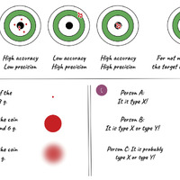 A) Accuracy vs. precision; B) visualisation of numerical differences; C) visualisation of uncertain or-relationships (F. Thiery, K. Tolle).
 -
 Left: Linked Open Data modelling using the Fuzzy Spatial Locations Ontology, based on the idea of PROV-O; right: modelling of hasMint in the Nomisma cookbook (left: F. Thiery; right: Zeena/nomisma.org, https://nomisma.hypotheses.org/1919)
 -
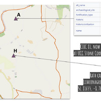 Left: current OSM map with the OSM Relation 6168494 (see A) and the possible position of CIIC 81 (see H), geo-referenced based on the path network using the plan of the location of (A) Lisnacaheragh Ringfort and (H) Lisheennagreine (from Ó Ríordáin, Ryan 1941, 80); right-top: description of OSM Way 562702954; right-bottom: Ogham Stone CIIC 81 in the UCC Stone Corridor, as well as the possible location coordinate (left/right-top: Open Street Map Contributors, ODbL, via OSM; right-bottom: F. Thiery)
 -
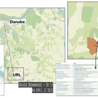 Left: schematic view of the distribution of the CI tephra in Europe (dashed orange line open to the E); Campi Flegrei as eruption site (orange dot; 40.8275° N, 14.1402° E); Urluia as find spot (blue dot/ rectangle; 44.0947° N, 27.9021° E); Eifel Lake sediment cores (red star); scale 1:20,000,000, EPSG: 3857, bounding box: −27,431.587, 3,598,880.852, 4,408,568.450, 7,668,605.656, created with QGIS, base map WorldTerrain by USGS, Esri, TANA, DeLorme, and NPS; middle: aerial line measurement between the possible location of Urluia (URL; purple rectangle) and the Danube. According to the literature, this is approx. 15 km, here 17.19 km; right: map showing the opencast mine (OSM way 84975654) and the possible Urluia coordinate point 44.0947 °N / 27.9021 °E as cisite_52 (purple rectangle) (left: F. Schenk, F. Thiery, https://codeberg.org/ResearchSquirrels/ci-map; middle/right: Open Street Map Contributors, ODbL, via OSM)
 -
 Visualisation of find spots for coins from Croton from coinhoards.org, external resources and literature entries (F. Thiery, S. Baars)
Position: 3901 (16 views)