

Using Kart and GitHub for versioning and collaborating with spatial data in archaeological research
- Title
- Using Kart and GitHub for versioning and collaborating with spatial data in archaeological research
- Creator(s)
- Andrea TitoloSee all items with this value
- Alessio PalmisanoSee all items with this value
- Date
- 2024
- Is Part Of
-
 Archeologia e Calcolatori
- Volume
- 35
- Issue
- 2
- Pages
- 107-118
- Language
- eng
- Rights
- CC BY-NC-ND 4.0
- Abstract
- Distributed Version Control Systems are one of the common ways through which scientists collaborate and keep track of different versions of their work. Moreover, scientists, programmers, etc., have been using platforms such as GitHub to host and share their resources versioned through Git. While not as widely adopted as in other disciplines, Git has also been used in archaeological research. In fact, DVCS allow scholars to collaborate remotely and offer the transparency necessary to align with Open Science and reproducible research practices. However, Git is highly inefficient when versioning GIS data. Kart, described as «an open source DVCS for geospatial and tabular data built on git», is a software addressing the need for collaboration and finer incorporation of geospatial data, providing also an integration with QGIS. Kart and code-hosting websites offers unique resources for archaeologists, from collaboration to more efficient workflows. In this paper, an example of how the authors are using Kart, QGIS, and GitHub in the project ‘Governance Policies and Political Landscapes in the Southern Levant under the Neo-Assyrian Empire’ will be presented. With this case study, the authors hope to provide a solution to the current gap in the workflow of documentation and collaboration among archaeologists using GIS.
- Zotero References Collection
- https://www.zotero.org/groups/5293298/bidiar/collections/FHLNT9VQ
- Cites
- Archaeological Landscapes of the Near East
- Openness and archaeology's information ecosystem
- Tool-Driven Revolutions in Archaeological Science
- The Manasseh Hill Country Survey, 4. From Nahal Bezeq to the Sartaba
- The Manasseh Hill Country Survey, 5. The Middle Jordan Valley, from Wadi Fasael to Wadi ‘Aujah
- The Manasseh Hill Country Survey, 3. From Nahal Iron to Nahal Shechem
- The Manasseh Hill Country Survey Volume 7: The South-Eastern Samaria Shoulder, from Wadi Rashash to Wadi 'Aujah
- The Manasseh Hill Country Survey Volume 6: The Eastern Samaria Shoulder, from Nahal Tirzah (Wadi Far'ah) to Ma’ale Ephraim Junction
- Judah, Philistia, and the Mediterranean World: Reconstructing the Economic System of the Seventh Century B.C.E.
- Ethical considerations for remote sensing and open data in relation to the endangered archaeology in the Middle East and North Africa project
- Computational Reproducibility in Archaeological Research: Basic Principles and a Case Study of Their Implementation
- Removing Barriers to Reproducible Research in Archaeology
- A Standard for the Scholarly Citation of Archaeological Data as an Incentive to Data Sharing
- Engineering Empire: A ah Perspective on the Middle Assyrian Empire
- Canals in the Neo-Assyrian Rural Landscape: A View from the Habur and Middle Euphrates
- The Neo-Assyrian Empire in the Southwest: Imperial Domination and its Consequences
- Highlands of Many Cultures: The Southern Samaria Survey: The Sites
- Tel Miqne-Ekron in the 7th Century B.C.E: The Impact of Economic Innovation and Foreign Cultural Influences on a Neo-Assyrian Vassal City-state
- Middle Bronze Age II Palestine: Its Settlements and Population
- Open archaeology: a survey of collaborative software engineering in archaeological research
- Open-archaeo: A Resource for Documenting Archaeological Software Development Practices
- Ashdod Revisited
- Ethics in Archaeological Lidar
- Assyria and the South
- The Imperialisation of Assyria: An Archaeological Approach
- Settlement and Demographic Processes in Israel's Coastal Plain from the Chalcolithic to the Middle Bronze Age
- Publishing and Pushing: Mixing Models for Communicating Research Data in Archaeology
- The archaeological exploration of the provinces of Assyria,
- The Creation of the Assyrian Heartland: New Data from the ‘Land behind Nineveh’
- Ekron under the Assyrian and Egyptian Empires
- Holocene landscape dynamics and long-term population trends in the Levant
- The Settlements and Population of Palestine during the Early Bronze Age II-III
- What’s the Big Picture?: Comparative Perspectives on the Archaeology of Empire
- Git can facilitate greater reproducibility and increased transparency in science
- Ashkelon and the Archaeology of Destruction: Kislev 604 Bce
- Archaeology of the Land of the Bible: The Assyrian, Babylonian, and Persian Periods, 732-332 BCE
- Reproducibility in the Field: Transparency, Version Control and Collaboration on the Project Panormos Survey
- The Manasseh Hill Country Survey, 1. The Shechem Syncline
- The Manasseh Hill Country Survey, 2. The Eastern Valleys and the Fringes of the Desert
Export
- Media
-
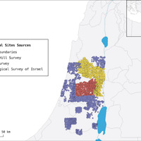 Project extent and archaeological sites digitized from different sources
 -
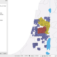 Kart QGIS plugin main interface with the list of available layers present in the database
 -
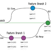 Simplified representation of Kart workflow
 -
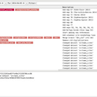 Example of Kart QGIS plugin visual commit log
 -
 Example of Kart QGIS plugin tabular (A) and visual (B) diff
Position: 3346 (17 views)