

‘Open’ architecture of UAVIMALS prototype and its archaeological use
- Title
- ‘Open’ architecture of UAVIMALS prototype and its archaeological use
- Creator(s)
- Federica VacatelloSee all items with this value
- Andrea VanniniSee all items with this value
- Date
- 2024
- Is Part Of
-
 Archeologia e Calcolatori
- Volume
- 35
- Issue
- 2
- Pages
- 119-128
- Language
- eng
- Rights
- CC BY-NC-ND 4.0
- Abstract
- The UAVIMALS system is a small airborne laser scanner prototype resulting from interdisciplinary research conducted by the Sapienza University of Rome and the Institute of BioRobotics of the Scuola Superiore S. Anna in Pisa. The project was financed by the National Geographic Society (Early Career Grant No. EC-50761T-18). Its aim was to develop an inexpensive and open source remote sensing system, test an engineered LiDAR sensor for autonomous vehicles, and create a specific aerial system for ‘micro-relief’ archaeological trace detection. The experiment conducted in the archaeological context of Leopolis-Cencelle (VT) demonstrated the effectiveness of a self-built open source hardware and software system that can be adapted to different types of archaeological visibility.
- Zotero References Collection
- https://www.zotero.org/groups/5293298/bidiar/collections/4V6Q25Y7
- Cites
- Leopoli-Cencelle il quartiere sud-orientale
- Sensing the Past: From artifact to historical site
- Interpreting Archaeological Topography: 3D Data, Visualisation and Observation
- Mapping Archeological Signs From Airborne Lidar Data Using Deep Neural Networks: Primary Results
- Le Liber Pontificalis: Texte, Introduction Et Commentaire, Volume 1, Part 1...
- Le pendici della città di Leopoli-Cencelle
- Paesaggi e sistemazioni agrarie nel basso corso dell’Adige da Montagnana al mare
Export
- Media
-
 Types of archaeological anomalies visible with aerial instrumentation (Satellite image from Landsat/Copernicus 2015)
 -
 Drone orthophoto of the archaeological site of Leopoli-Cencelle (VT)
 -
 Anomalies detected by SIAT flights in the aerial surveys conducted at the Cencelle site between ’94 and ’95 (graphic reelaboration by F. Vacatello from Del Lungo 2003)
 -
 a) Front perspective of the sensor view cone; b) sensor point of view; c) example of data acquired within a single bin; d, e) satellite view of the Leopoli-Cencelle (VT) archaeological site and flight mission planning
 -
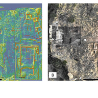 a) Slope map highlighting identified anomalies corresponding to the profiles of specific rooms (the values represent the slope degree); b) drone orthophoto of the SW area of the Cencelle site taken in September 2020
Position: 2536 (19 views)