

The GISTArc webGIS for the accessibility and sharing of archaeological data in Campania
- Title
- The GISTArc webGIS for the accessibility and sharing of archaeological data in Campania
- Creator(s)
- Giuseppina RendaSee all items with this value
- Carmine CivaleSee all items with this value
- Sabrina MatalunaSee all items with this value
- Pacifico CofrancescoSee all items with this value
- Date
- 2024
- Is Part Of
-
 Archeologia e Calcolatori
- Volume
- 35
- Issue
- 2
- Pages
- 299-310
- Language
- eng
- Rights
- CC BY-NC-ND 4.0
- Abstract
- The GISTArc project envisions the implementation of a webGIS environment for the management and visualization of geoarchaeological data from research included in the Archaeological Map of Northern Campania project, conceived and directed by Stefania Quilici Gigli. The creation of the new system began with the normalization of some completed research data. They were managed in a GIS environment and were subsequently imported into a Web geodatabase, with the preparation of layers containing all the textual, graphical/ photographical and spatial information of the catalogued archaeological evidence, together with the required bibliographical references. The GISTArc project has a threefold aim: make the results of archaeological research conducted in some sectors of northern Campania more usable; allow the researcher to consult, integrate and enter the data from future research, thanks to the connection to the system via the Internet and the possibility of recording data directly during the survey; and finally access via standard desktop applications, such as Quantum GIS and ArcGIS, rather than the internet-based GISTArc geodatabase, in order to use advanced data analysis and representation functions that may not be available online. This paper describes the technical and scientific approach to the creation of our webGIS. It focuses on the system architecture, operative environment, and development tools.
- Zotero References Collection
- https://www.zotero.org/groups/5293298/bidiar/collections/HD2YT77V
- Cites
- Un’infrastruttura di ricerca per l’archeologia: il progetto ARIADNE
- Geospatial semantics, ontology and knowledge graphs for big Earth data
- Tracce di storia nel paesaggio: dalla ricerca alla pianificazione,
- Carta archeologica e ricerche in Campania, Atlante Tematico di Topografia Antica
- Il Sistema Informativo territoriale e la gestione delle informazioni archeologiche in ambiente GIS: qualche osservazione
- Landscape archaeology in the Ager Telesinus: Scientific results and land-use planning
- L’approccio multimediale per la comunicazione di aspetti funzionali complessi dell’Anfiteatro Campano
- ---Comunicazione e fruizione dei beni archeologici
- Dalla Carta archeologica della Campania alla Carta delle Potenzialità Archeologiche, Esperienze a Sturno e Bellona per una strategia condivisa di pianificazione del territorio
- Carta Archeologica della Campania. Ricerche condotte e in corso per la promozione del territorio
- Lettura topografica dei dati archeologici dall’età sannitica all’epoca imperiale
- Semantic Enablement for Spatial Data Infrastructures
Export
- Media
-
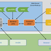 Architecture of the GISTArc web application
 -
 GISTArc basic screen (above) and toolbar panels
 -
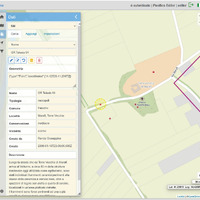
 Information windows, synthetic (left) and extended (right)
 -
 Data modification panel, by an authenticated ‘editor’ type user
 -
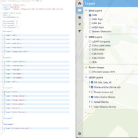 The configuration file and the layers panel
 -
 GeoJSON layer with database fields description
 -
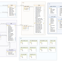 Database architecture
Position: 4409 (13 views)