

Old data, old methodology and new research. A case study of legacy data integration from the Cestrine Region, Epirus
- Title
- Old data, old methodology and new research. A case study of legacy data integration from the Cestrine Region, Epirus
- Creator(s)
- Julian BogdaniSee all items with this value
- Domizia D'ErasmoSee all items with this value
- Date
- 2024
- Is Part Of
-
 Archeologia e Calcolatori
- Volume
- 35
- Issue
- 2
- Pages
- 323-332
- Language
- eng
- Rights
- CC BY-NC-ND 4.0
- Abstract
- In the context of the joint archaeological project in Çuka e Ajtoit (Albania) by Sapienza University of Rome and the Albanian Institute for Archaeology, new archaeological field research is being conducted in the Southern fringes of the Albanian territory. The area of interest extends from the site of Butrint (UNESCO Heritage site) to the Albano-Greek border, and corresponds to ancient Cestrine, renowned in the literary sources for its pastoral resources and Trojan connections. The study integrates the freshly acquired information collected during the field campaigns, characterized by a high degree of technological innovation, with old research data poorly published up to present. This paper concerns the photogrammetric processing of historical aerial imagery acquired for mapping purposes by the Italian Military Geographical Institute (IGMI) in the 1930s, during the war context of the invasion of Albania by Fascist Italy. The process resulted in the creation of a DTM and an orthomosaic by using SfM algorithms and GNSS topographical surveys, representing the shape of the landscape of the late 1930s, i.e., before the realization of extensive land reclamation programs by the socialist regime that have determined the radical changes of the current landscape.
- Zotero References Collection
- https://www.zotero.org/groups/5293298/bidiar/collections/8YUCKZ7E
- Cites
- Storia della cartografia Italiana delle Isole Egee e dell'Albania
- Butrint 7: Beyond Butrint: Kalivo, Mursi, Cuka E Aitoit, Diaporit and the Vrina Plain. Surveys and Excavations in the Pavllas River Valley, Albania, ... the Pavllas River Valley, Albania, 1928-2015
- Rielaborare legacy data per lo studio del paesaggio dell’Albania meridionale: il caso delle foto aeree della Royal Air Force (RAF)
- History of military aerial photographs in Italy and addressed archives
- Le necropoli di Çuka e Ajtoit : vecchie e nuove ricerche a confronto
- Kërkime të reja Shqiptaro-Italiane në Çukën e Ajtoit / New Archaeological Research at Çuka e Ajtoit
- Documentare l'invisibile. Il progetto Çuka e Ajtoit: rilievo e documentazione di un sito d'altura
- ΚΕΣΤΡΙΑ ΤHΣ ΧΑΟΝIΑΣ: appunti sulla geografia e storia di una regione di frontiera
Export
- Media
-
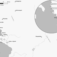 Geographical position of the region of Cestrine and of the site of Çuka e Ajtoit
 -
 An example of the metadata reported in each frame and of the chemical deterioration of the support, which makes half of the image illegible
 -
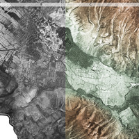 Compared view of: the orthophoto mosaic (a), overlaid with the DEM, as a hillshade view (b), and as false color view (c), and curves (d).
 -
 Position and coordinates (WGS 84) of the GCP used to georeference the 3D model
 -
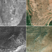 Compared view of two sites of archaeological interest detected on the historical orthomosaic, compared to present-day satellite images
 -
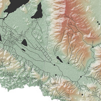 Detailed view of the vectorisation process of the historical images (vectorisation by Elena Urzì).
Position: 11291 (9 views)