

Mapping the archaeological landscapes of San Basilio (Ariano nel Polesine, Rovigo)
- Title
- Mapping the archaeological landscapes of San Basilio (Ariano nel Polesine, Rovigo)
- Creator(s)
- Jacopo TurchettoSee all items with this value
- Elisa ConsoloSee all items with this value
- Giacomo MoroSee all items with this value
- Date
- 2024
- Is Part Of
-
 Archeologia e Calcolatori
- Volume
- 35
- Issue
- 2
- Pages
- 333-342
- Language
- eng
- Rights
- CC BY-NC-ND 4.0
- Abstract
- Between the end of the Seventies and the beginning of the Eighties of the Twentieth century, following the discovery of numerous occasional findings, the village of San Basilio (Ariano nel Polesine, Rovigo, Italy) had been the object of a series of archaeological campaigns, which made it possible to identify a pre-Roman settlement and a Roman <em>villa/mansio</em> linked to the passage of the via Annia/via Popillia. In the past few years, the research has been resumed in that area, carrying out both archaeological and topographical activities, aimed at reconstructing the organisation of the ancient landscape. The aim of this contribution is twofold: on the one hand, the planned research activities are presented and, on the other, the opportunity can arise to discuss about the potentialities of digital approaches in mapping the archaeological landscapes of San Basilio.
- Zotero References Collection
- https://www.zotero.org/groups/5293298/bidiar/collections/LK92GNG2
- Cites
- Cluster analysis, classificazione numerica e remote sensing. Metodi di analisi integrati applicati alla survey presso San Basilio di Ariano nel Polesine (RO)
- Trasparenze di paesaggi Atlante aerofotografico del Polesine
- La questione Popillia-Annia tra Padova e Adria
- San Basilio tra storia e leggenda, Taglio di Po (Rovigo)
- La nuova via Annia da Roma ad Aquileia (153a.C.)
- Ambiente e strutture antropiche nell’antico Polesine
- Ritrovamenti monetali nell’agro di S. Basilio (Ariano Polesine)
- Carta Archeologica del Veneto
- Archeologia e paesaggio nell'area costiera veneta. Conoscenza, partecipazione e valorizzazione.
Export
- Media
-
 The lower Polesine and the localisation (red dot) of San Basilio (basemap: Google Earth)
 -
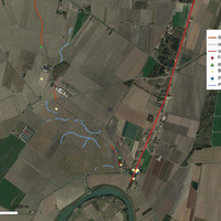
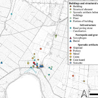 Archaeological map of the area of San Basilio (QGIS elaboration E. Consolo)
 -
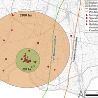 Map with areas of lower and higher concentration of archaeological finds discovered in San Basilio (QGIS elaboration E. Consolo).
 -
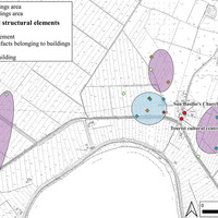 Areas of concentration of public (turquoise) and private (purple) buildings in San Basilio (QGIS elaboration E. Consolo).
 -
 The layout of the road leading towards Chioggia (QGIS elaboration G. Moro).
 -
 Traces of a plausible route in the locality of Tombe, near San Basilio (basemap: Google Earth)
 -
 Overall map of the evidence analysed in the territory of San Basilio (QGIS elaboration G. Moro)
 -
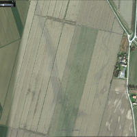
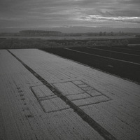 DJI Mavic M3M Red Edge (RE) image of alfalfa fields, with evident traces of a Roman building (photo J. Turchetto).
Position: 3349 (17 views)