

IN-ROME – The INscribed city: urban structures and interaction in imperial Rome
- Title
- IN-ROME – The INscribed city: urban structures and interaction in imperial Rome
- Date
- 2024
- Is Part Of
-
 Archeologia e Calcolatori
- Volume
- 35
- Issue
- 2
- Pages
- 343-354
- Language
- eng
- Rights
- CC BY-NC-ND 4.0
- Abstract
- This paper describes the objectives and methodological approaches of the project ‘IN-ROME – The INscribed city: urban structures and interaction in imperial ROME’. The project aims at mapping as comprehensively as possible a wide range of activities that shaped both the physical environment and the relationships between its inhabitants. Focussing on the time period between the 1 st century BCE and the 3<sup>rd</sup> century CE, and on the area outside the 4<sup>th</sup> century BCE ‘Servian’ Walls up to about the 9<sup>th</sup> mile of Rome’s consular roads, it draws on archaeological, literary and archival sources. In addition, and crucially, it aims to virtually re-contextualise c. 50,000 inscriptions in the Epigraphic Database Roma with a known provenance from the area, thus restoring agency to the archaeological landscape. To this end, a new webGIS is being developed that allows for the topographical visualisation of all relevant data.
- Zotero References Collection
- https://www.zotero.org/groups/5293298/bidiar/collections/ICY8JFSC
- Cites
-
 Zotero2Map: sviluppo di un nuovo strumento ITC per la condivisione e la pubblicazione dei dati bibliografici per la ricerca storica e archeologica
- PAThs: sulla creazione di un geo-database aperto dedicato all’Egitto tardoantico e medievale
- MOvEIT: A proof of concept of a road graph for late antique Egypt
- 7 City Sizes and Urbanization in the Roman Empire
- Rome's Cultural Revolution
- The Place of Complexity
- Vici et Pagi dans l'Occident romain
- Rethinking Ostia: A Spatial Enquiry into the Urban Society of Rome's Imperial Port-Town
- Self-organisation and spatial planning: an editorial introduction
- Regiones quattuordecim
- Lexicon topographicum urbis Romae. Volume Primo, A-C
- Political Space: The Architecture of Squatter Settlements in São Paulo, Brazil
- The Republican Aventine and Rome's Social Order
- Il primo miglio della Via Appia a Roma. Atti della giornata di studio
- Regions and neighbourhoods
- The Neighborhoods of Augustan Rome
- L’agro Vaticano
- Peasants, Citizens and Soldiers: Studies in the Demographic History of Roman Italy 225 BC-AD 100
- Rome, Ostia, Pompeii: Movement and Space
- Roman Pompeii: Space and Society
- The City Shaped: Urban Patterns and Meanings Through History
- The Urban Dialogue: An Analysis of the Use of Space in the Roman City of Empuries, Spain
- Campus Martius: The Field of Mars in the Life of Ancient Rome
- The archaeological map of Ancona: New IT tools
- Shopping in Ancient Rome: The Retail Trade in the Late Republic and the Principate
- Stadterfahrung Als Sinneserfahrung in Der Romischen Kaiserzeit
- Urbem Adornare: Die Stadt Rom und ihre Gestaltumwandlung unter Augustus / Rome’s urban metamorphosis under Augustus
- Mapping Augustan Rome
- An Urban Geography of the Roman World, 100 BC to AD 300
- In Omnibus Regionibus? The Fourteen Regions and the City of Rome
- Working Together: Clusters of Artisans in the Roman City
- The Dancing Lares and the Serpent in the Garden: Religion at the Roman Street Corner
- Horti Romani.
- The True Burial Site of Peter and Paul? Christians and Jews on the Appian Way
- The Atlas of Ancient Rome: Biography and Portraits of the City
- Forms of self-organization: Urban complexity and planning implications
- Herodes Atticus in Rome: The Triopion reconsidered
- City Phenomenon between Urban Structure and Composition
- Urban Evolution, Self-Organization, and Decisionmaking
- Cities and Regions as Self-Organizing Systems: Models of Complexity
- Campus Martius: Die urbane Entwicklung des Marsfeldes von der Republik bis zur mittleren Kaiserzeit
- Lexicon topographicum urbis Romae. Volume Secondo, D-G
- Lexicon topographicum urbis Romae. Volume Terzo, H-O
- Lexicon topographicum urbis Romae. Volume Quinto, T-Z
- Lexicon topographicum urbis Romae. Volume Quarto, P-S
- Lexicon Topographicum Urbis Romae. Volume Sesto, Indici, Addenda et corrigenda
Export
- Media
-
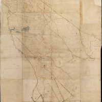 Mapsheet AGRO-161 of the Catasto Gregoriano dell’Agro Romano showing «Vigne poste fuori le Porte di San Sebastiano, Latina e San Giovanni con le tenute di Caffarella ed Arcotravertino»
 -
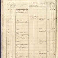 Page 14 from the land register (brogliardo) of Mapsheet AGRO-161 of the Catasto Gregoriano dell’Agro Romano, here Fig. 1.
 -
 Directus Flow diagram, from EDR API to new database table
 -
 Map of inscriptions showing for each point the list of inscriptions found in the same location
Position: 2893 (18 views)