

Labels and symbols: using text on maps to investigate the antiquities on the ordnance survey maps of Great Britain
- Title
- Labels and symbols: using text on maps to investigate the antiquities on the ordnance survey maps of Great Britain
- Creator(s)
- Valeria VitaleSee all items with this value
- Katherine McDonoughSee all items with this value
- Date
- 2024
- Is Part Of
-
 Archeologia e Calcolatori
- Volume
- 35
- Issue
- 2
- Pages
- 355-362
- Language
- eng
- Rights
- CC BY-NC-ND 4.0
- Abstract
- This paper discusses the application of a machine learning pipeline to automatically digitise text on historical maps and make it searchable, as explored by the ‘Machines Reading Maps’ project. Looking at the Ordnance Survey Maps of Great Britain as a case study, we will suggest ways in which this new kind of open datasets, of both a textual and spatial nature, offers the unprecedented opportunity to study maps at scale, analysing map collections as digital corpora. These new approaches facilitate the use of map as historical sources in humanities research, and their investigation as complex cultural objects that combine heterogeneous knowledge. In particular, we will focus on the uncommonly detailed representation of ancient sites on the Ordnance Survey maps, and how a further layer of information around them is delivered not by the words’ literal meaning but by their appearance. We will propose ways in which this peculiarity could be digitally leveraged to retrace, investigate, and perhaps re-interpret the archaeological information on the Ordnance Survey maps. We will conclude by reflecting on the need for new, more sophisticated workflows that take into account the richness of information delivered by visual clues in words printed on maps.
- Zotero References Collection
- https://www.zotero.org/groups/5293298/bidiar/collections/B9LIWLRP
- Cites
- Searching maps by words: how machine learning changes the way we explore map collections
- Background to the semiotic study of maps
- Archaeology in the Ordnance Survey
- A Description of the Large Scale Maps of Great Britain. produced and published by the Ordnance Survey, with Specimens, Symbol Sheet, and Diagrams: Sixth Edition
- An Overview of Recent Trends in OCR Systems for Manuscripts
- Using early modern maps in literary studies: Views and caveats from London
- Maps of a Nation? The Digitized Ordnance Survey for New Historical Research
- Map Of A Nation: A Biography of the Ordnance Survey
- Victorian Culture and Classical Antiquity: Art, Opera, Fiction, and the Proclamation of Modernity
- The Irish Ordnance Survey: History, Culture and Memory
- Archæology and the Ordnance Survey
- 'The Spade Might Soon Determine It': The Representation of Deserted Medieval Villages on Ordnance Survey Plans, 1849–1910
- Locating Past Places in Britain: Creating and Evaluating the GB1900 Gazetteer
- The mapKurator System: A Complete Pipeline for Extracting and Linking Text from Historical Maps
- The collection of antiquarian information for the early Ordnance Survey maps of Scotland
- The Ordnance Survey
Export
- Media
-
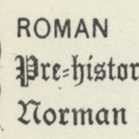 Characters of the writing on the engraved Six Inch Ordnance Maps of Great Britain, 1897, National Library of Scotland
 -
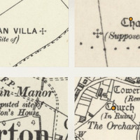 Examples of the representation of non extant heritage on early OS maps, 1:6000 (composite screenshots from GB1900 portal)
 -
 Example of the representation of archaeological events on early OS maps, 1:6000 (from GB1900 portal)
Position: 7755 (12 views)