

Investigating resilient Roman agricultural landscapes in southern Italy. An integrated and open IT approach to modeling centuriation
- Title
- Investigating resilient Roman agricultural landscapes in southern Italy. An integrated and open IT approach to modeling centuriation
- Creator(s)
- Rodolfo BrancatoSee all items with this value
- Veronica FerrariSee all items with this value
- Immacolata DitarantoSee all items with this value
- Pasquale MerolaSee all items with this value
- Irene RossiSee all items with this value
- Date
- 2024
- Is Part Of
-
 Archeologia e Calcolatori
- Volume
- 35
- Issue
- 2
- Pages
- 387-400
- Language
- eng
- Rights
- CC BY-NC-ND 4.0
- Abstract
- The In.Res.Agri project aims to optimize the understanding of Roman agricultural landscapes in Southern Italy by integrating topographical, archaeological, environmental, and textual data within an innovative data-science platform. It focuses on examining the resilience of Roman agrarian landscapes, specifically through elements such as centuriation, route networks, and settlement patterns. The project employs both traditional survey methods and advanced technologies to recover, interpret, and manage archaeo-topographical data related to centuriation. Key methods include using Machine Learning for the automatic detection of centuriated fields, spatial analysis of both legacy and new data, and the use of annotated epigraphic and literary sources. All collected data will be implemented into the Digital_Groma platform, which will feature a digital archive and a webGIS for data display and querying; data will be exposed adhering to FAIR principles. In.Res.Agri will focus on regions in Campania (Vesuvian Area, Irpinia) and Puglia (Tavoliere), exploring the link between contemporary landscapes and Roman centuriated agro-ecosystems. This research is crucial for understanding the impact of environmental changes on Cultural Heritage, aligning with the priorities of the European Commission and UNESCO. The Digital_Groma platform will be accessible to researchers, tourists, and public institutions involved in archaeology, urban planning, and cultural heritage protection.
- Zotero References Collection
- https://www.zotero.org/groups/5293298/bidiar/collections/VQZRL6KF
- Cites
- Archaeological computing and ancient cities: insights from the repository of «Archeologia e Calcolatori»
- Digital Archiving in Archaeology: The State of the Art. Introduction
- Landscape Pattern Detection in Archaeological Remote Sensing
- Lo sguardo di Icaro. Collezioni dell'aerofototeca nazionale per la conoscenza del territorio
- Landscaping and integrating Digital Archaeology and Digital Epigraphy resources: new challenges and future opportunities. Introduction to the Special section
- Sources et Techniques de l'Archeogeographie
- L’Agro vesuviano dopo l’eruzione del 79 d.C.
- Sulle vie che ricalcano gli antichi assi centuriali
- Methodological insights into the study of centuriated field systems
- Le ricerche sui resti della centuriazione cinquant'anni dopo
- La reconstitution d'un paysage antique : l'ager Campanus
- Sur la centuriation de l'ager Campanus : la limite sud-est
- Termini muti di centurazione o contropesi di torchi ?
- Le paysage aux époques historiques:un document archéologique
- A comparison of three image-object methods for the multiscale analysis of landscape structure
- Misurare la terra: centuriazione e coloni nel mondo romano
- Un territorio per due città: Suessula e Acerra
- Le centuriazioni di Luceria e Aecae.
- Il Tavoliere romano. L'agricoltura romana attraverso l'aerofotografia e lo scavo
- Taphonomies of landscape: investigating the immediate environs of Çatalhöyük from prehistory to the present
- L'Hirpinia fra III e I sec. a.C.: agro pubblico, assegnatari viritani, giurisdizione delegata, assetto istituzionale
- Ager Campanus: atti del convegno internazionale : la storia dell'Ager Campanus, i problemi della limitatio e sua lettura attuale: Real sito di S. Leucio, 8-9 giugno 2001
- Il contributo della fotografia aerea allo studio delle antiche divisioni agrarie in Irpinia Orientale
- Centuriazione e geografia fisica
- Apolline Project vol. 1: studies on Vesuvius' North Slope and the Bay of Naples |
- Regimazione idraulica di età romana nelle pianure di foce delle Marche settentrionali
- Uomo, acqua e paesaggio: atti dell'incontro di studio sul tema irreggimentazione delle acque e trasformazione del paesaggio antico : S. Maria Capua Vetere, 22-23 novembre, 1996
- Cadastres et espace rural: approches et réalités antiques : table ronde de Besançon, mai 1980
- Structures agraires en Italie centro-méridionale : Cadastres et paysages ruraux
- Traité d'archéogéographie: La crise des récits géohistoriques
- Fonti tradizionali e nuove metodologie d’indagine per la ricostruzione della centuriazione attribuita all’ager Aecanus nel Tavoliere di Puglia
- Le ricerche sui resti della centuriazione
- IT applications to archaeology and the OA diamond journals’ challenge. Enhancing access and reuse of textual and visual resources
- How to access ancient landscapes? Field survey and legacy data integration for research on Greek and Roman settlement patterns in Eastern Sicily
- Implementing State-of-the-Art Deep Learning Approaches for Archaeological Object Detection in Remotely-Sensed Data: The Results of Cross-Domain Collaboration
- Integrating Remote Sensing, Machine Learning, and Citizen Science in Dutch Archaeological Prospection
- Human communities living in the central Campania Plain during eruptions of Vesuvius and Campi Flegrei
- Note sull'Irpinia in età romana, in Studi sull'Irpinia antica, Napoli 2021, 89-130
- Un nuovo termine graccano dall'ager di Compsa
- Archaeogeography and planimetric landscapes
- Non-invasive archaeological research in Atella (Sant’Arpino-Campania, Italy). Preliminary results from the 2023 campaign
- ‘Buried Landscapes’ in Southern Italy
- Risultati delle più recenti indagini archeologiche nell'area dell'antica Atella.
- Mapping the Archaeological Continuum. Filling “Empty” Mediterranean Landscapes
- Sistemi centuriali e opere di assetto agrario tra età ro- mana e primo medioevo. Atti del Convegno (Borgoricco-Lugo 2009)
Export
- Media
-
 Distribution map of the case studies in the context of Southern Italy
 -
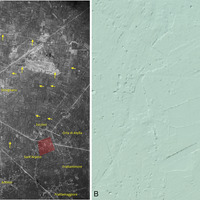
 The site of Atella and its hypothesized cadastral layout (case study 1) plotted on a 1:25,000 scale topographic map (A) and within the broader context of Campania region (B)
 -
 Atella and its territory (case study 1) as seen in a historical aerial photograph (RAF 1945) annotated by G. Scardozzi (A) and in the DTM with a 1-meter ground resolution derived from LiDAR scanning acquired by the Ministry of the Environment of Italy
 -
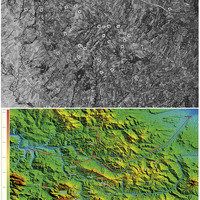 The territory of Irpinia (case study 2) in DEM (A) and historical aerial photograph (B) analised by the Archaeological Mapping Lab of ISPC-CNR (Lecce)
 -
 Northern Apulia (case study 3), centuriation systems as seen in and aerial photograph (A) and DEM (B) analised by the Laboratorio di Topografia Antica e Fotogrammetria LABTAF (Lecce)
 -
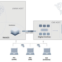 Components of the In.Res.Agri project’s IT platform, the Digital_Groma
 -
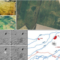
 Examples of vectors obtained through machine learning application in a GIS platform
Position: 3900 (16 views)