

Use and processing of multispectral images in proximity remote sensing
- Title
- Use and processing of multispectral images in proximity remote sensing
- Creator(s)
- Laura EbanistaSee all items with this value
- Date
- 2024
- Is Part Of
-
 Archeologia e Calcolatori
- Volume
- 35
- Issue
- 2
- Pages
- 401-410
- Language
- eng
- Rights
- CC BY-NC-ND 4.0
- Abstract
- The contribution presents the results of a research that involves the use of data acquired by a multispectral camera transported by a UAV and their analysis and interpretation in the context of archaeological diagnostics. The experimentation expected the acquisition of multispectral images and the extraction of all the possible vegetation indexes on the basis of the spectral bands of the specific camera used (Sentera 6X). The tests, carried out in different contexts (Antium, Nersae), analyze the readability of the index data extracted from multispectral images in comparison with the marks visible in the panchromatic images, especially considering cases in which the marks are visible only in processed indices that interpolate the NIR band.
- Zotero References Collection
- https://www.zotero.org/groups/5293298/bidiar/collections/4HFVEGBJ
- Cites
- Towards an Archaeological Index: Identification of the Spectral Regions of Stress Vegetation due to Buried Archaeological Remains
- Manuale di aerofotografia archeologica. Metodologia, tecniche e applicazioni
- Mosaici antichi in Italia. Regione prima. Ercolano - Libro - Fabrizio Serra Editore - | IBS
- Trattato di botanica. Parte generale
- Aerial mapping and multi-sensors approaches from remote sensing applied to the roman archaeological heritage
- Un Iseion a Gravisca? Fotogrammetria, telerilevamento multispettrale da APR e dati archeologici per una possibile identificazione
- Anzio, villa comunale: un nuovo complesso residenziale sostruito di età imperiale. Sondaggi di scavo 2023
- Telerilevamento di prossimità: acquisizione ed elaborazione di immagini multispettrali
- Integrazione di un sensore Sentera 6X a bordo di un drone Phantom 4. Una sperimentazione in campo archeologico
- Monitoring vegetation systems in the great plains with erts
- UAV-Based Multispectral Phenotyping for Disease Resistance to Accelerate Crop Improvement under Changing Climate Conditions
- Evaluation of Broadband and Narrowband Vegetation Indices for the Identification of Archaeological Crop Marks
- Anzio. La villa imperiale
Export
- Media
-
 Anzio (RM), Villa Adele. Comparison of the panchromatic image and the NDVI index
 -
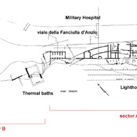 Anzio (RM), Villa Imperiale. Plan of the known structure with the addition of the structures identified based on the NDVI marks in 2023 (processed by Jaia 2008, 76)
 -
 Anzio (RM), Villa Imperiale. Comparison between the panchromatic image and the NDVI index
 -
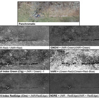 Nersae, Pescorocchiano (RI). Comparison between the panchromatic image and six vegetation indices
 -
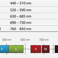 Spectral Bands (from https://www.geosoluciones.cl/documentos/rapideye/RE_Red_Edge_Band_White_Paper.pdf).
 -
 Anzio (RM), Villa Imperiale. Comparison between the panchromatic image and six vegetation indices
 -
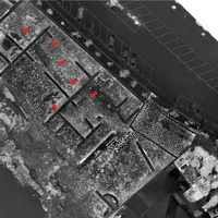 Anzio (RM), Villa Imperiale. NDVI index
Position: 12912 (5 views)